- Joined
- Feb 21, 2024
- Messages
- 95
My friend and longtime hiking buddy reached out to me just before the new year saying he'd landed a seven day permit to trek through the Gem Canyons on the western section of Grand Canyon's Tonto Trail in mid March, and before I'd put too much thought to the idea I said 'I'm in.' This trip would take us from South Bass Canyon west to the Boucher Trail, in and out of Serpentine, Ruby, Turqoise, Sapphire, Agate, Slate, & Topaz Canyons with a side hike down to Crystal Rapids on the Colorado River itself on the docket.
Plans, as they so often do on these big trips, evolved en route, but we managed to start from and finish at the suggested points without too much self damage along the way.
We'd driven south from Colorado and made it to the hotel in Tusayan late the evening prior, and we'd coordinated a 7 AM pickup by a local driver who'd promised to drive us west to the dropoff point to access South Bass Trailhead. The road to the trailhead has been closed since 2020 due to it crossing Havasupai land, the tribe having shut down transit access due to the pandemic itself. That means you have a hefty walk just to reencounter the road in, with six to seven miles often needed on foot just to get to the rim and descent.
It had snowed twice in the previous four days, and while the road itself had seen the snow covering it melt off, what remained as the road was effectively frozen mud - hence why Jason, our awesome driver, wanted to pick us up so early. He needed to get us as far in and get himself back out before that frozen mud melted back into soup and made the road basically impassable. That he did after an hour on the service road, and he even got us a little bit further on the usage track that had been established since the existing road's closure, and left us with a little less than a five mile road walk to reach the trailhead.
Had we left later in the day (and therefore needed less water to get through the day), we were kicking around camping high along the red wall; however, since we were starting so early, we decided we'd push all the way down to where the South Bass Trail met the Tonto and find the Bass tanks roughly a mile below, since that was the first 'dependable' water source we'd come across all day. Water carries would be a recurring theme the entire trip, as finding anything more than a series of puddles on this section is considered an oasis.
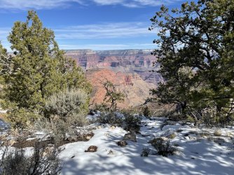
When we reached South Bass Trailhead, it was evident that the trail's initial descent into the canyon was still blanketed with snow. While it would have been nice to avoid wet shoes, we'd each made the commitment to bring gear in case of snow - yaktrax for me, microspikes for my buddy - and there's something backpackingly therapeutic about needing the gear you've chosen to haul on a trip even if it does mean hauling extra weight the entire trip. For perhaps the first 700-800 feet of descent, we welcomed the traction as we worked our way down through the juniper and pine on snow, frequently getting glimpses of the drier trail (and canyon expanse) below us.
As the trail emerged from the trees and into the sun, 'the trail emerging' became a thing of the past. The low traffic and general rockiness of the path was a recurring theme beyond just South Bass, the loose rubble and narrow track making for an incredibly slow-going downclimb. In all, we knew we'd be dropping some ~4,300 feet with full packs on Day 1, but the speed with which we dropped them ended up much, much slower than anticipated. Even when it flattened in spots, the trail wound through cacti and sagebrush that would rip at your ankles if you weren't precise in your steps, the cactus needles sticking through your shoes if you kicked them in the wrong spots.
By the time we made it to the Tonto shelf, we were completely gassed - my buddy had tweaked his lower back with an early misstep, and the tendonitis I've been battling in my right foot had flared up several miles before we stopped. We found a series of flat spots above the trail junction, however, and had stellar views down canyon of Holy Grail Temple (6,711 ft) on the north rim. The weather had been perfect all day and was supposed to remain that way through the evening, so we set up cowboy camps under the stars after limping further down to Bass tanks to fill up with water.
The descent had grinded us to a pulp and we knew we'd have to scratch and claw back up later in the week, but the beauty of the scene paired with the satisfaction of having made it down conspired for a hell of a first night's sleep under Milky Way skies. Also, the whiskey.
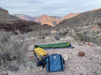
My luxury item for the trek was my Crazy Creek chair, and that decision paid off in spades when I woke up on Day 2 devoid of the tendonitis pain. As it turns out, those chairs are perfect for rocking back and getting your feet elevated, and that's precisely what I'd done over a pair of ibuprofen and a myriad whiskey sips for the bulk of the evening at camp. After sleeping with them elevated, too, the pain and stiffness in my foot I'd worried about as I fell asleep was mostly gone, and the ~9 mile trek east to Ruby Canyon suddenly seemed much less daunting.
We'd be working our way towards the river before the classic Tonto trek in and out of the massive side canyons of the region, first through Serpentine and a pair of smaller, unnamed canyons before reaching Ruby and the reported potholes of water in its depths. The bright skies of Day 1 were around that morning, but we knew there was rain in the forecast for later that evening (and for the following day), so the goal was to make an efficient push to Ruby and be set before any rain rolled in.
We finally got our first views of the Colorado River mid-morning as we worked our way first east to the tip of South Bass Canyon and then south towards the mouth of Serpentine Canyon. The Tonto Trail was relatively smooth going on the approach to Serpentine despite being hard to stay on, the softness under foot being a more clear indication you'd left the trail than any demarcation.
Once in Serpentine, though, the trail became tricky and more technical walking once again, with bigger rocks under foot and significantly more exposure above the dry wash. It took nearly two hours to walk our way to the back, turn the corner over the pour-off, an emerge further upriver on the southeast side. The rest of the afternoon was dedicated to traversing through a pair of smaller side canyons with similar obstacles - tricky rocks, copious cacti, the occasional slickrock walks, and increasing clouds.
We reached the back of Ruby Canyon at some point after 4 PM and set up tents at the edge of the wash, with potholes beside us that would grow in size overnight as the rains moved in.
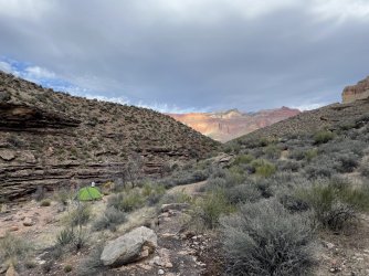
The third day of the trip greeted us with a variety of challenges, the first of which being wet, cooler weather that included a strong shower that hit right as we began cooking a hot breakfast. That sent me back to the tent for some half-cooked oatmeal and a cup of coffee, but the rain lightened enough shortly after to let us break camp and get back on the trail (with my decision to roll with a cheap emergency poncho as a backpack rain cover both functional and fashionable all day.)
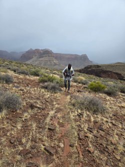
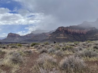
We also had a short ~6 mile day into Turqoise Canyon, an amount that, in theory, would give us ample time to either take our time or have plenty leftover after getting to camp. Considering we were set to spend the next two nights in (or around) Slate Canyon with a side-trek down to the river at Crystal Rapids, we could even push past the water source in Turqoise to set us up for an even shorter Day 4. Figuring that out was initially going to be a see-how-it-goes decision, but it instead began to be made for us.
That gets us to the first big challenge of the day.
My buddy found out he was diabetic about ~20 years ago, and has dealt with it admirably ever since. It rarely, if ever, slows him down (the dude has done way, way bigger trips than I have), and to his credit it wasn't necessarily his diabetes that slowed him down on this day. Instead, it was the updated insulin delivery system he'd began wearing just a couple of weeks before the trip and the monitoring app that was connected to it. It was consistenly giving him low blood sugar readings (and beeping its ass off each time that crossed a low threshold), and the problem that created was twofold.
First, he began burning through his candybar cache much quicker than he anticipated to keep the readings high enough, even doing so despite not feeling like it was that low. Second, he began to get worried that the monitor/app would notify his doctor if it repeatedly stayed low, something he wasn't exactly in a position to talk his way out of while devoid of cell service at the bottom of the Grand Canyon (note: we did have a Garmin inReach, but the idea of repeatedly having to lean on that to explain that he was actually fine was exhausting just thinking about).
As we walked along the Tonto above the river, it began to become more evident that while we had ample food to be just fine for a full 7-day trip, the peripheral factors may dicate we get out earlier than that. Then, when we reached the back of Turqoise and the potholes that it contained for our water, I discovered that Part A of my Aquamira water treatment system had cracked and begun to leak, and suddenly getting out far quicker than seven days became a foregone conclusion.
We still had most of a separate Aquamira set to lean on, but it was far from full. We could also, in theory, boil water before drinking it, but we'd not budgeted enough fuel to do that for every water treatment for four more days while also leaning on it for rehydrating meals, so that became a risk that was too big to take.
We decided we'd treat as much water as we could out of my Aquamira set before it leaked out, haul it out to a dry camp on the eastern outlet of Turqoise Canyon, and plot a two-day exit plan that would get us up and out Boucher Canyon to Hermit's by the end of our fifth day. We wouldn't be cutting the trip short distance-wise, we'd just be trimming the would-be side trip to the river and doubling up our final day so as to stick to the permit that had us staying near Slate Canyon on night four, ditching the idea of camping at Yuma Point off the Boucher Trail for the final night in lieu of hiking all the way the hell out in a big, big day five.
The rain, at least, skipped out early that afternoon, and while it was still chilly enough to pitch tents that night, the skies were clear and the stargazing was as good as I've ever witnessed.
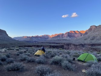
The fourth and fifth days were supposed to be the 'vacation' within this trip, a packless side trip down to sit in the sun by Crystal Rapids and leaving camp set up for back to back nights a respite on our journey. Instead, Day 4 became both our exit-setup day and a day of gluttony. We'd packed enough food for a 7-day trip (with requisite extra meal in case we needed it), and shedding as much weight as possible before the ~4,300 foot climb up and out Boucher Canyon the next day became paramount.
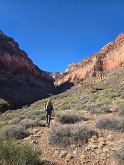
I had dehydrated bacon bits to chuck into some mashed potatoes multiple times, so we ate that. We housed a family-sized bag of bold Chex Mix. The salami log and block cheddar got sent to the woodchipper over an extended lunch along the actually moving trickle at the base of Sapphire Canyon, and we each took down our biggest ~700 calorie dehydrated dinners once we set up camp on the east exit of Slate Canyon with Marsh Butte over our shoulder.
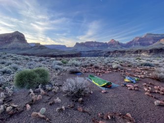
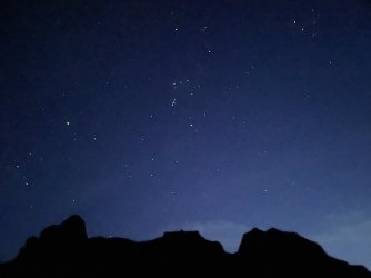
The entire trip after sunset we'd seen Orion emerge behind us to the south with the big dipper in front of us to the north, our orientation consistent enough to prompt a reminder of what it must have been like for folks looking skyward daily before light pollution. They became anticipated, our familiar starry neighbors, and I find it no coincidence that there was a perfect, cloudless sky for our final night out on the trip.
I won't mince words here - Day 5 of this trip was brutal.
It started off innocently enough, with a beautiful morning and a short descent from our camp on the edge of Slate Canyon down into Topaz Canyon and the fully flowing Boucher Creek. It was close enough that we'd decided to walk the two-ish miles to the creek and cook a big breakfast with coffee there, to water up as much as possible before making the push up and out the Boucher Trail to Hermit's Rest.
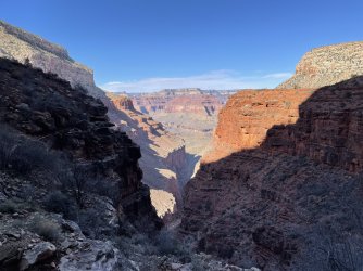
It would end up a 13-14 mile day, one that tested both our fitness and morale as we climbed through layer after layer the Canyon's depth threw at us. There were the occasional class 3 moves with more exposure than my exhausted body cared for, and a long horseshoe shaped curve as we neared Hermit's with some pretty shear cliffs. That came after we'd passed Yuma Point and where we'd originally planned to camp on the sixth night of our trip (but avoided on night five since it wasn't on our permit), the views from that location making you feel as minuscule as possible while still on solid ground.
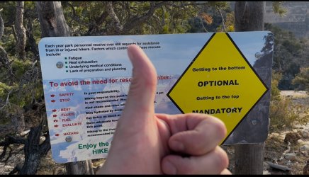
We made it up to Hermit's Rest as the busses were dropping off the masses for sunset viewing, our stinking husks begging questions as we kerhyucked around giddily in exhausted celebration. Eventually we made it back to our car, found a room back in Tusayan, and plowed through as many collective enchiladas as we could stomach before crashing.
**************************************************************************************************
That western section of the Tonto is infintely different from its eastern sibling, which I'd spent a week backpacking back in February of 2020. The eastern section is far from easy, but it is traversed enough to feature trails that are hard to lose and the side canyons have not just dependable, but flowing water during the early parts of the year. The Escalante route even keeps you down at the Colorado River for multiple stops, and water never truly seems to be a major issue along the way. There is significantly more up and down on that route, which is difficult in its own right, but I don't remember it as trail where you constantly needed to stare at your feet in order to progress - in fact, I think I wore shorts and short socks the entire time.
This time around was the polar opposite. Narrow trails, constant rock and rubble that could roll an ankle, and brush and cacti galore just waiting to rip and stab you. You'd lose the trail in two steps if you dared look around while walking, and that goes for the main Tonto shelf as well as back in the Gems themselves. Quite simply, this section was simultaneously hard to get to, hard to stick to, and hard to move on, and it's no surprise in hindsight that we saw a grand total of two folks - both solo backpackers - the entire time we were out until the final ~800 foot push up to Hermit's.
The western Tonto beat me up, but didn't scar me. It taught me lessons along the way, and gave me a hell of a ride in the process.
Plans, as they so often do on these big trips, evolved en route, but we managed to start from and finish at the suggested points without too much self damage along the way.
We'd driven south from Colorado and made it to the hotel in Tusayan late the evening prior, and we'd coordinated a 7 AM pickup by a local driver who'd promised to drive us west to the dropoff point to access South Bass Trailhead. The road to the trailhead has been closed since 2020 due to it crossing Havasupai land, the tribe having shut down transit access due to the pandemic itself. That means you have a hefty walk just to reencounter the road in, with six to seven miles often needed on foot just to get to the rim and descent.
Day 1
It had snowed twice in the previous four days, and while the road itself had seen the snow covering it melt off, what remained as the road was effectively frozen mud - hence why Jason, our awesome driver, wanted to pick us up so early. He needed to get us as far in and get himself back out before that frozen mud melted back into soup and made the road basically impassable. That he did after an hour on the service road, and he even got us a little bit further on the usage track that had been established since the existing road's closure, and left us with a little less than a five mile road walk to reach the trailhead.
Had we left later in the day (and therefore needed less water to get through the day), we were kicking around camping high along the red wall; however, since we were starting so early, we decided we'd push all the way down to where the South Bass Trail met the Tonto and find the Bass tanks roughly a mile below, since that was the first 'dependable' water source we'd come across all day. Water carries would be a recurring theme the entire trip, as finding anything more than a series of puddles on this section is considered an oasis.

When we reached South Bass Trailhead, it was evident that the trail's initial descent into the canyon was still blanketed with snow. While it would have been nice to avoid wet shoes, we'd each made the commitment to bring gear in case of snow - yaktrax for me, microspikes for my buddy - and there's something backpackingly therapeutic about needing the gear you've chosen to haul on a trip even if it does mean hauling extra weight the entire trip. For perhaps the first 700-800 feet of descent, we welcomed the traction as we worked our way down through the juniper and pine on snow, frequently getting glimpses of the drier trail (and canyon expanse) below us.
As the trail emerged from the trees and into the sun, 'the trail emerging' became a thing of the past. The low traffic and general rockiness of the path was a recurring theme beyond just South Bass, the loose rubble and narrow track making for an incredibly slow-going downclimb. In all, we knew we'd be dropping some ~4,300 feet with full packs on Day 1, but the speed with which we dropped them ended up much, much slower than anticipated. Even when it flattened in spots, the trail wound through cacti and sagebrush that would rip at your ankles if you weren't precise in your steps, the cactus needles sticking through your shoes if you kicked them in the wrong spots.
By the time we made it to the Tonto shelf, we were completely gassed - my buddy had tweaked his lower back with an early misstep, and the tendonitis I've been battling in my right foot had flared up several miles before we stopped. We found a series of flat spots above the trail junction, however, and had stellar views down canyon of Holy Grail Temple (6,711 ft) on the north rim. The weather had been perfect all day and was supposed to remain that way through the evening, so we set up cowboy camps under the stars after limping further down to Bass tanks to fill up with water.
The descent had grinded us to a pulp and we knew we'd have to scratch and claw back up later in the week, but the beauty of the scene paired with the satisfaction of having made it down conspired for a hell of a first night's sleep under Milky Way skies. Also, the whiskey.

Day 2
My luxury item for the trek was my Crazy Creek chair, and that decision paid off in spades when I woke up on Day 2 devoid of the tendonitis pain. As it turns out, those chairs are perfect for rocking back and getting your feet elevated, and that's precisely what I'd done over a pair of ibuprofen and a myriad whiskey sips for the bulk of the evening at camp. After sleeping with them elevated, too, the pain and stiffness in my foot I'd worried about as I fell asleep was mostly gone, and the ~9 mile trek east to Ruby Canyon suddenly seemed much less daunting.
We'd be working our way towards the river before the classic Tonto trek in and out of the massive side canyons of the region, first through Serpentine and a pair of smaller, unnamed canyons before reaching Ruby and the reported potholes of water in its depths. The bright skies of Day 1 were around that morning, but we knew there was rain in the forecast for later that evening (and for the following day), so the goal was to make an efficient push to Ruby and be set before any rain rolled in.
We finally got our first views of the Colorado River mid-morning as we worked our way first east to the tip of South Bass Canyon and then south towards the mouth of Serpentine Canyon. The Tonto Trail was relatively smooth going on the approach to Serpentine despite being hard to stay on, the softness under foot being a more clear indication you'd left the trail than any demarcation.
Once in Serpentine, though, the trail became tricky and more technical walking once again, with bigger rocks under foot and significantly more exposure above the dry wash. It took nearly two hours to walk our way to the back, turn the corner over the pour-off, an emerge further upriver on the southeast side. The rest of the afternoon was dedicated to traversing through a pair of smaller side canyons with similar obstacles - tricky rocks, copious cacti, the occasional slickrock walks, and increasing clouds.
We reached the back of Ruby Canyon at some point after 4 PM and set up tents at the edge of the wash, with potholes beside us that would grow in size overnight as the rains moved in.

Day 3
The third day of the trip greeted us with a variety of challenges, the first of which being wet, cooler weather that included a strong shower that hit right as we began cooking a hot breakfast. That sent me back to the tent for some half-cooked oatmeal and a cup of coffee, but the rain lightened enough shortly after to let us break camp and get back on the trail (with my decision to roll with a cheap emergency poncho as a backpack rain cover both functional and fashionable all day.)

We also had a short ~6 mile day into Turqoise Canyon, an amount that, in theory, would give us ample time to either take our time or have plenty leftover after getting to camp. Considering we were set to spend the next two nights in (or around) Slate Canyon with a side-trek down to the river at Crystal Rapids, we could even push past the water source in Turqoise to set us up for an even shorter Day 4. Figuring that out was initially going to be a see-how-it-goes decision, but it instead began to be made for us.

That gets us to the first big challenge of the day.
My buddy found out he was diabetic about ~20 years ago, and has dealt with it admirably ever since. It rarely, if ever, slows him down (the dude has done way, way bigger trips than I have), and to his credit it wasn't necessarily his diabetes that slowed him down on this day. Instead, it was the updated insulin delivery system he'd began wearing just a couple of weeks before the trip and the monitoring app that was connected to it. It was consistenly giving him low blood sugar readings (and beeping its ass off each time that crossed a low threshold), and the problem that created was twofold.
First, he began burning through his candybar cache much quicker than he anticipated to keep the readings high enough, even doing so despite not feeling like it was that low. Second, he began to get worried that the monitor/app would notify his doctor if it repeatedly stayed low, something he wasn't exactly in a position to talk his way out of while devoid of cell service at the bottom of the Grand Canyon (note: we did have a Garmin inReach, but the idea of repeatedly having to lean on that to explain that he was actually fine was exhausting just thinking about).
As we walked along the Tonto above the river, it began to become more evident that while we had ample food to be just fine for a full 7-day trip, the peripheral factors may dicate we get out earlier than that. Then, when we reached the back of Turqoise and the potholes that it contained for our water, I discovered that Part A of my Aquamira water treatment system had cracked and begun to leak, and suddenly getting out far quicker than seven days became a foregone conclusion.
We still had most of a separate Aquamira set to lean on, but it was far from full. We could also, in theory, boil water before drinking it, but we'd not budgeted enough fuel to do that for every water treatment for four more days while also leaning on it for rehydrating meals, so that became a risk that was too big to take.
We decided we'd treat as much water as we could out of my Aquamira set before it leaked out, haul it out to a dry camp on the eastern outlet of Turqoise Canyon, and plot a two-day exit plan that would get us up and out Boucher Canyon to Hermit's by the end of our fifth day. We wouldn't be cutting the trip short distance-wise, we'd just be trimming the would-be side trip to the river and doubling up our final day so as to stick to the permit that had us staying near Slate Canyon on night four, ditching the idea of camping at Yuma Point off the Boucher Trail for the final night in lieu of hiking all the way the hell out in a big, big day five.
The rain, at least, skipped out early that afternoon, and while it was still chilly enough to pitch tents that night, the skies were clear and the stargazing was as good as I've ever witnessed.

Day 4
The fourth and fifth days were supposed to be the 'vacation' within this trip, a packless side trip down to sit in the sun by Crystal Rapids and leaving camp set up for back to back nights a respite on our journey. Instead, Day 4 became both our exit-setup day and a day of gluttony. We'd packed enough food for a 7-day trip (with requisite extra meal in case we needed it), and shedding as much weight as possible before the ~4,300 foot climb up and out Boucher Canyon the next day became paramount.

I had dehydrated bacon bits to chuck into some mashed potatoes multiple times, so we ate that. We housed a family-sized bag of bold Chex Mix. The salami log and block cheddar got sent to the woodchipper over an extended lunch along the actually moving trickle at the base of Sapphire Canyon, and we each took down our biggest ~700 calorie dehydrated dinners once we set up camp on the east exit of Slate Canyon with Marsh Butte over our shoulder.

The entire trip after sunset we'd seen Orion emerge behind us to the south with the big dipper in front of us to the north, our orientation consistent enough to prompt a reminder of what it must have been like for folks looking skyward daily before light pollution. They became anticipated, our familiar starry neighbors, and I find it no coincidence that there was a perfect, cloudless sky for our final night out on the trip.

Day 5
I won't mince words here - Day 5 of this trip was brutal.
It started off innocently enough, with a beautiful morning and a short descent from our camp on the edge of Slate Canyon down into Topaz Canyon and the fully flowing Boucher Creek. It was close enough that we'd decided to walk the two-ish miles to the creek and cook a big breakfast with coffee there, to water up as much as possible before making the push up and out the Boucher Trail to Hermit's Rest.

It would end up a 13-14 mile day, one that tested both our fitness and morale as we climbed through layer after layer the Canyon's depth threw at us. There were the occasional class 3 moves with more exposure than my exhausted body cared for, and a long horseshoe shaped curve as we neared Hermit's with some pretty shear cliffs. That came after we'd passed Yuma Point and where we'd originally planned to camp on the sixth night of our trip (but avoided on night five since it wasn't on our permit), the views from that location making you feel as minuscule as possible while still on solid ground.

We made it up to Hermit's Rest as the busses were dropping off the masses for sunset viewing, our stinking husks begging questions as we kerhyucked around giddily in exhausted celebration. Eventually we made it back to our car, found a room back in Tusayan, and plowed through as many collective enchiladas as we could stomach before crashing.
**************************************************************************************************
That western section of the Tonto is infintely different from its eastern sibling, which I'd spent a week backpacking back in February of 2020. The eastern section is far from easy, but it is traversed enough to feature trails that are hard to lose and the side canyons have not just dependable, but flowing water during the early parts of the year. The Escalante route even keeps you down at the Colorado River for multiple stops, and water never truly seems to be a major issue along the way. There is significantly more up and down on that route, which is difficult in its own right, but I don't remember it as trail where you constantly needed to stare at your feet in order to progress - in fact, I think I wore shorts and short socks the entire time.
This time around was the polar opposite. Narrow trails, constant rock and rubble that could roll an ankle, and brush and cacti galore just waiting to rip and stab you. You'd lose the trail in two steps if you dared look around while walking, and that goes for the main Tonto shelf as well as back in the Gems themselves. Quite simply, this section was simultaneously hard to get to, hard to stick to, and hard to move on, and it's no surprise in hindsight that we saw a grand total of two folks - both solo backpackers - the entire time we were out until the final ~800 foot push up to Hermit's.
The western Tonto beat me up, but didn't scar me. It taught me lessons along the way, and gave me a hell of a ride in the process.
Last edited:
