Glacier national park fire

It has doubled in size now since this morning.
We have hiked a lot through this area and it is heartbreaking to see this happen.
IRG
 
Its suppose to get extremely windy this afternoon, which can make things really, really bad. As of right now, the Going to the Sun road is closed several miles west of Logan Pass, and the entire east side is closed to St Mary. Their is talk that they are going to evacuate St Mary, and make that fire camp. St Mary campground is closed as well. The fire is on both sides of the roads, I know it jumped the road at Reynolds Creek. It spread real fast last night and this morning. They are fighting it, they have no intention of allowing this to burn. There is some concern about Many Glacier. The ridge south of Shebrume reservoir is full of fuel, and if the fire spreads there, if would burn extremely fast and trap in Many Glacier. Where the fire is now is also full of fuel.

Gunsight Lake, Reynolds Creek, Otakomi Lake, and the Red Eagle Lake backcountry campsites are closed. Anyone trying to do the CDT won't be able to get through right now, and will have to reroute. The Gunsight Pass trail is still open from the west side, but its closed at the pass. They evacuated everyone from Gunsight Lake last night. Made them leave without packing up their tents. But anyone hiking up to Sperry or Ellen Wilson is still fine for the moment.

The fire is moving east, north east. Hopefully they get it contained quickly. I've heard no mention of containment at all though. It's been pretty clear today over Lake McDonald, although it rained this morning. I'm noticing a little smoke, but not too bad on the west side. Driving out to Columbia Fall last night, I could see the smoke rising up pretty big from the center of the park. I can see a little right now, but I'm a little low in the valley.

There is still plenty of backpacking that can be done right now. I'm heading out this afternoon for a 9 day trip in the southern section of the park. My original plan was to do some off trail routes north west of Triple Divide, in the Red Eagle Pass area, and they wouldn't let me do that. But all of the Dawson/Pitamakin/Two Med Pass area is open.

Hopefully they get it all contained real soon. But their is some real serious concern right now here in the park. Especially if the winds pick up. It has been extremely hot and dry up here this summer. I've never seen it this dry.

As Doug said its a really beautiful area, and heartbreaking to see it burn. Hopefully things get better soon.
 
Thanks for the info Joey!
I was hoping you could chime in with a first hand account. Glad to see that it hasn't interrupted your plans too much. Hopefully the weather will improve to help the fight. If you haven't done so already. You need to do the Dawson / Pitamakan loop. Too bad Triple Divide is closed, that is an incredible area, right on the edge of a previous burned area.
Safe travels,..with your remaining time there
IRG
 
Starting a loop right now going that way. I'm heading up Park Creek, over Two Medicine Pass (which is just as neat as the others), going over Dawson, Pitamakan, then Cut Bank Pass and down to Beaver Woman Lake for a few nights. I'll complete the loop by hiking back to Park Creek.

Originally I was going to go over to Triple Divide Pass, and then do the Norris Traverse to Red Eagle Pass and on to Gunsight Lake. But the fire puts an end to that.

And of course, things may change if the fire spreads. Or if new ones start. There has been several small fires already this year. Kind of reminds me of Yellowstone in 1988, where the conditions were so dry.
 
Dry conditions and half the trees are dead. Long run, this is probably the only thing that can resolve the pine beetle infestation problem, and the lingering effects of it (dead trees all over the Rockies north of Colorado.)

However, it's only good news long term. For decades, it's going to really suck. :(
 
It's always sad to see fires burn. However like you said, in the long run it's not a bad thing, and in fact quite beneficial for the forests.
 
The Going To The Sun Road is now open all the way through. There are nightly closures at the moment. The fire burned a large chunk of the woods along the road between the Wild Goose Island pullout and the Gunsight Pass/Jackson Glacier Overlook pullout. Almost that entire stretch is burned. Everything around Sun Rift Gorge is burned. The slopes above Rising Sun Motor Inn are burned, and so it the drainage up to Otakomi Lake. Looks like it burned right down to ST Mary's lake. The area around St Mary Falls is burned pretty bad as well.

The rumor is that the Reynolds Creek backcountry site is where the fire started, and that that area is completely burned. But the Gunsight Trailhead is not burned, and it appeared that most of the route up to Gunsight Lake avoided the fire. At least that's how it looked from driving past it.

Here are 2 shots of the valley as we drove into St Mary's a week ago. Most of this is out now.
11800619_10153548218714766_7309380149972850856_n.jpg


11825614_10153548218669766_6444927283730422717_n.jpg
Thanks for the update Joey.
The pictures are very sad to me. I know that area well. They say they probably won't have the fire totally contained until snow flies. I relieved the Gunsight areas not badly affected, although there was a ton of avalanche debris along that route that could have benefited from a burn.
Looks like it might have burned up to the previously burned Red Eagle area.
Thanks again for updates.
On a little lighter side.
Only two weeks from our Winds trip and three from our Tetons trip.
I know your heading that way soon too.
Still got you penciled in as our Teton shuttle.
Lmk if things change.
I will PM you with my phone number
To finalize details.
See ya soon
IRG

Doug and Anita
I'll be heading down there sometime this week, so we are still good for the shuttle.

I was just told there is another fire burning now in the Nyack, on the other side of Red Eagle Pass. I'm not sure how big it is, or if it is related to the Reynolds Creek Fire.
 
I love the Nyack area, and really hope it doesn't burn to much of it. The Coal Creek side is already burned.

Right now the park has closed the following backcountry campsites:
All 4 in the Nyack Zone, and any dispersed camping. Also closed are Old Man Lake, Morning Star Lake, and Atlantic Creek. I don't know if the trails are closed going over Pitamakin or Triple Divide Passes, but these closures may effect anyone trying to hike that section of the park.

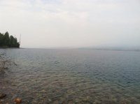
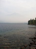
Its smoky here at Lake McDonald. First time I've seen it smokey here.
 
That will affect a lot of people's plans. It's a very popular route from St Mary to Two Med.
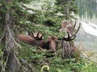
Morningstar is such a beautiful place. We lost count of how many goats you could see at one time on the many cliffs above. Not to mention the sheep and moose in that area too. It has special meaning to us.

Cheers
IRG

Big Bull @ Morningstar
image.jpg
 
Nice! I have an interesting bear story from Morning Star I will have to tell you about. Kind of a good one :)
 
Nice! I have an interesting bear story from Morning Star I will have to tell you about. Kind of a good one :)

Looking forward to it.
If I remember right, you had another memorable bear encounter in the Teton's.
Cheers
IRG
 
Real smoky today on the west side, and the entire Flathead Valley. Smelled like fire. A few pictures of Lake McDonald:
11868627_10155866872440247_378652896_n.jpg 11119937_10155866871835247_1567116460_n.jpg
 
Back
Top