wes242
This one time...
- Joined
- Feb 4, 2012
- Messages
- 605
I have been looking at doing this hike for years, but never planned to do it till a few months ago. My wife and I have heard great things about Coyote Gulch so we took some time off to give it a shot. Now there are so many ways that you can do this hike that is the major battle in planning….. Which way to go? Originally we planned to hike down The Crack and spend a few day heading up and then back out. After looking at other peoples hikes and seeing that they do a loop I thought we could do that too. We once it came down to it we were going to head down the steep section at Jacob Hamblin Arch and hang around a few days then come back up. That was the plan anyway.
Wednesday night Sept 14th, 2011 we headed down to Hole in the Rock road after work and we were going to camp out somewhere and get an early start. Well the weather wasn’t the best this week, tons of rain, and you know slot canyons and rain bring on floods! We made it about 5 miles down the dirt road till we hit some mud that was so slick that I would have rather been in snow. Being dark we turned back to town and hit a Cowboy Theme Motel….. We talked about bagging the trip and heading to Moab instead. The next morning we headed back out now that we could see! Still a little slick but not to bad this time, and that one spot was the worst. We made it all the way out to the trailhead with no issues. The weather didn’t look to bad other then the puffy clouds. So we packed up and off we headed for Hamblin.

Markai, the Happy Hiker for now.
The hike out across the sand and slick rock wasn’t too bad, and had some great sights and tons of pools of water. Looked like it had been raining a bit to have pools everywere. We passed a group of about 8 guys heading back to the trailhead and told us to watch out ahead cause of the steep trail dropping in they made a mess in their shorts if you know what I mean as they were climbing out. As we got closer to the canyon I started to wonder if this was really the trail, but I followed my GPS and the Carins so it had to be. I have talked to a few people that have dropped in here so we came with a rope, and good thing we did to lower our packs down and play it a little safe. It was slow going down, we made sure we found the right and safe route to the bottom. By the time we were down our legs were wore out! So we found a spot down the canyon to figure out what we were really going to do. After we got some food in us and our energy level back up then we put together a plan to do the loop and hike out The Crack. We didn’t what to hike back up that steep face, not with packs on anyway. While we were sitting there 2 other people came hiking by to chat. They had a rough night cause the rain rose the river a foot and they had to get to a safe spot. They were hiking out the Red Well area, which is the longest route that I know of. After them we headed down to the place I wanted to see the most, Swiss Cheese Falls.

The steep trail down to Jacob Hamblin Arch.
I didn’t really know what to expect with this spot since I have only seen pictures. The first time I saw it I thought it would be bigger, but it really wasn’t. Still this was an awesome area with a nice campsite to stay at. We thought about staying here, but it was to early in the day and we wanted to keep moving. So after a bit of some photos we headed on our way. The guy we had just talked to said that Coyote Bridge wasn’t in the Sun when they passed it but it should be for us. That was our next spot to get to, but all the quicksand made it a little challenging.

Swiss Cheese Falls
We got the the Bridge and we were both feeling great. We took a handfull of pictures and even thought this would be our next Christmas card photo. It is always fun to send out a photo like this in the cold winter to everyone to try and make them jealous. Hope it works this year. We both realized that since we have been in the canyon we have only seen 2 people. I thought this place would have had tons of people in it since September is one of the best times of year to go there. Maybe all the rain forcasts scared people away. As for this day of hiking there wasn’t any rain or storm clouds to be seen. I couldn’t believe that mother nature was going to be nice to me for once. We continued down the canyon and started looking for a good spot to camp for the night. We wanted to stay up a little higher cause who knew what the night was going to be like, and I already have horrible dreams of sleeping in a river that I didn’t what it to come true. Still the quicksand was everywhere, and we found a nasty spot. It sunk me past my knees in no time. I grabed Markai’s feet just in case, and she had a hold of some branches on the bank. She got up out of it and then I was able to crawl out too. That isn’t fun with a big pack on, but made for something to remember.

Us at Coyote Natural Bridge
I saw some Carins heading up the side of a hill and wondered where they were going. It was to Cliff Arch, and to a flat spot high above the water. This was the spot we were going to stay. We set up camp and looked at the map to see how far we made it down. We went further then we though, and discussed just hiking all the way out the following day. It was mid afternoon when we got there so we had a long rest and enjoyed the veiws. We had a big scare while sitting there at camp, 3 F-16s flew right over us just above the rim of the canyon. It was so loud, but also pretty sweet since it had been so quiet on this hike not seeing anyone.

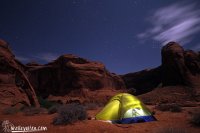
Middle of the night taking some shots.
I wanted to take some pictures once the Sun went down and I woke up about 9 to see some stars out. Yeah I said woke up at 9! We went to bed early. There were some bright Stars out, but I could tell the Moon was rising soon and it started to wash out the sky a little. I woke up again about 3:30am and was surprised how warm it still was. Plus I was glad it wasn’t raining on us either. I took some more shots now that the Moon lite up the cliffs to add a bit of some color. I would like to do more with night shots, but don’t like to leave my camera out while I am sleeping.

Don't let the photo fool you, but hiking up this sucks.
So our plan was to hike down the canyon, then head up the sandy hill, go up the crack, trek back the the road, stash our packs, and then walk to the truck. It was easier said then done, however that is what we did with no problems, other then the challenge of the trail heading up and the hot sun. The rest of the canyon down was pretty awesome, and the funny thing is the smell of it reminds me of the Jungle smell in Mexico. We passed one other group that was down about a mile or so from where we were camping next to the best looking bathroom I have ever seen out in the middle of nowhere. I had to make sure to make the best of that one! There were a few waterfalls that I always thought I would stop and take some long delay shots of in my original plans for this hike, but that didn’t happen. Some other time maybe. We stopped for lunch at a Spring that was flowing pretty nice and easy to fill up our water with. I really didn’t want to have to drink out of the muddy river and that was another reason my pack weight a bit more then I would like. Since I packed a ton of water with. We only had to filter 32oz of water, but that filtered water still tastes better then the plastic taste out of my 6 liter Dromlite bag. All ready for the sand hill………. the worst thing ever to hike up in the Sun. I forgot my hat and sunscreen was buried. We slowly went up the hill, and I pointed to where we were going to. My wife didn’t like that one bit! It was to far away. But we made it and also realized that coming down this way would be so fast. At least the sand was holding some moisture so it wasn’t as bad as most sand to hike in. It was the Sun and heat the made it bad.

Me squeezing through the crack
Now to get up the Crack…. it is really easy to do unless you have a pack to get up, and who wouldn’t have one out here. This is another spot you really need a rope to pull your back up past the skinny section. There are some groves in the rocks from the years of people doing this. The downside is I had a skinny rope for the light weight of it, but it made it hard to pull up the bags with not much to grip. A little rope burn happend but it was all worth it to be on top of the hill. While we were getting up this spot some guy was yelling to see if he could get a jump on his car. His battery was dead and he needed help. I told him we were 2 miles past his spot, but we would come back to help him. We stashed our packs once we got to the road so we make the last coupld miles not so bad. But he was no where to be seen once we got to the road. We still had some hiking back to the truck though and he knew that. There were footprints going all over the place, it looked like he had been there a while, and in a car too. This isn’t a road I would drive my car down cause of the sand. Still we hadn’t seen many people at all on this trip, and we wondered what this guys story was. Finally the truck!! Best thing I had seen in the past 4 miles. The funny thing is once we got to the truck people started showing up all over the place. We went back to get our packs and help this guy who was waiting at his car for us. At least it fired right up once we hooked it up. He told us they had been there like 6 days and he stayed back to wait for help while his friend hiked down to the river to camp. I gave him a gallon of water since I had 3 gallons in the truck just in case. I don’t know what he did for all those days by himself but we were glad to help.
So the original planned for 3 night hike turned into an overnighter, but it was a good time and gave me something to think about next time I plan to do this hike.
See most of our pictures from this trip check them out here…. wesleyaston.com
Or here……… Wesley Aston Facebook
And a video of the hike...
Wednesday night Sept 14th, 2011 we headed down to Hole in the Rock road after work and we were going to camp out somewhere and get an early start. Well the weather wasn’t the best this week, tons of rain, and you know slot canyons and rain bring on floods! We made it about 5 miles down the dirt road till we hit some mud that was so slick that I would have rather been in snow. Being dark we turned back to town and hit a Cowboy Theme Motel….. We talked about bagging the trip and heading to Moab instead. The next morning we headed back out now that we could see! Still a little slick but not to bad this time, and that one spot was the worst. We made it all the way out to the trailhead with no issues. The weather didn’t look to bad other then the puffy clouds. So we packed up and off we headed for Hamblin.

Markai, the Happy Hiker for now.
The hike out across the sand and slick rock wasn’t too bad, and had some great sights and tons of pools of water. Looked like it had been raining a bit to have pools everywere. We passed a group of about 8 guys heading back to the trailhead and told us to watch out ahead cause of the steep trail dropping in they made a mess in their shorts if you know what I mean as they were climbing out. As we got closer to the canyon I started to wonder if this was really the trail, but I followed my GPS and the Carins so it had to be. I have talked to a few people that have dropped in here so we came with a rope, and good thing we did to lower our packs down and play it a little safe. It was slow going down, we made sure we found the right and safe route to the bottom. By the time we were down our legs were wore out! So we found a spot down the canyon to figure out what we were really going to do. After we got some food in us and our energy level back up then we put together a plan to do the loop and hike out The Crack. We didn’t what to hike back up that steep face, not with packs on anyway. While we were sitting there 2 other people came hiking by to chat. They had a rough night cause the rain rose the river a foot and they had to get to a safe spot. They were hiking out the Red Well area, which is the longest route that I know of. After them we headed down to the place I wanted to see the most, Swiss Cheese Falls.

The steep trail down to Jacob Hamblin Arch.
I didn’t really know what to expect with this spot since I have only seen pictures. The first time I saw it I thought it would be bigger, but it really wasn’t. Still this was an awesome area with a nice campsite to stay at. We thought about staying here, but it was to early in the day and we wanted to keep moving. So after a bit of some photos we headed on our way. The guy we had just talked to said that Coyote Bridge wasn’t in the Sun when they passed it but it should be for us. That was our next spot to get to, but all the quicksand made it a little challenging.

Swiss Cheese Falls
We got the the Bridge and we were both feeling great. We took a handfull of pictures and even thought this would be our next Christmas card photo. It is always fun to send out a photo like this in the cold winter to everyone to try and make them jealous. Hope it works this year. We both realized that since we have been in the canyon we have only seen 2 people. I thought this place would have had tons of people in it since September is one of the best times of year to go there. Maybe all the rain forcasts scared people away. As for this day of hiking there wasn’t any rain or storm clouds to be seen. I couldn’t believe that mother nature was going to be nice to me for once. We continued down the canyon and started looking for a good spot to camp for the night. We wanted to stay up a little higher cause who knew what the night was going to be like, and I already have horrible dreams of sleeping in a river that I didn’t what it to come true. Still the quicksand was everywhere, and we found a nasty spot. It sunk me past my knees in no time. I grabed Markai’s feet just in case, and she had a hold of some branches on the bank. She got up out of it and then I was able to crawl out too. That isn’t fun with a big pack on, but made for something to remember.

Us at Coyote Natural Bridge
I saw some Carins heading up the side of a hill and wondered where they were going. It was to Cliff Arch, and to a flat spot high above the water. This was the spot we were going to stay. We set up camp and looked at the map to see how far we made it down. We went further then we though, and discussed just hiking all the way out the following day. It was mid afternoon when we got there so we had a long rest and enjoyed the veiws. We had a big scare while sitting there at camp, 3 F-16s flew right over us just above the rim of the canyon. It was so loud, but also pretty sweet since it had been so quiet on this hike not seeing anyone.
Middle of the night taking some shots.
I wanted to take some pictures once the Sun went down and I woke up about 9 to see some stars out. Yeah I said woke up at 9! We went to bed early. There were some bright Stars out, but I could tell the Moon was rising soon and it started to wash out the sky a little. I woke up again about 3:30am and was surprised how warm it still was. Plus I was glad it wasn’t raining on us either. I took some more shots now that the Moon lite up the cliffs to add a bit of some color. I would like to do more with night shots, but don’t like to leave my camera out while I am sleeping.

Don't let the photo fool you, but hiking up this sucks.
So our plan was to hike down the canyon, then head up the sandy hill, go up the crack, trek back the the road, stash our packs, and then walk to the truck. It was easier said then done, however that is what we did with no problems, other then the challenge of the trail heading up and the hot sun. The rest of the canyon down was pretty awesome, and the funny thing is the smell of it reminds me of the Jungle smell in Mexico. We passed one other group that was down about a mile or so from where we were camping next to the best looking bathroom I have ever seen out in the middle of nowhere. I had to make sure to make the best of that one! There were a few waterfalls that I always thought I would stop and take some long delay shots of in my original plans for this hike, but that didn’t happen. Some other time maybe. We stopped for lunch at a Spring that was flowing pretty nice and easy to fill up our water with. I really didn’t want to have to drink out of the muddy river and that was another reason my pack weight a bit more then I would like. Since I packed a ton of water with. We only had to filter 32oz of water, but that filtered water still tastes better then the plastic taste out of my 6 liter Dromlite bag. All ready for the sand hill………. the worst thing ever to hike up in the Sun. I forgot my hat and sunscreen was buried. We slowly went up the hill, and I pointed to where we were going to. My wife didn’t like that one bit! It was to far away. But we made it and also realized that coming down this way would be so fast. At least the sand was holding some moisture so it wasn’t as bad as most sand to hike in. It was the Sun and heat the made it bad.

Me squeezing through the crack
Now to get up the Crack…. it is really easy to do unless you have a pack to get up, and who wouldn’t have one out here. This is another spot you really need a rope to pull your back up past the skinny section. There are some groves in the rocks from the years of people doing this. The downside is I had a skinny rope for the light weight of it, but it made it hard to pull up the bags with not much to grip. A little rope burn happend but it was all worth it to be on top of the hill. While we were getting up this spot some guy was yelling to see if he could get a jump on his car. His battery was dead and he needed help. I told him we were 2 miles past his spot, but we would come back to help him. We stashed our packs once we got to the road so we make the last coupld miles not so bad. But he was no where to be seen once we got to the road. We still had some hiking back to the truck though and he knew that. There were footprints going all over the place, it looked like he had been there a while, and in a car too. This isn’t a road I would drive my car down cause of the sand. Still we hadn’t seen many people at all on this trip, and we wondered what this guys story was. Finally the truck!! Best thing I had seen in the past 4 miles. The funny thing is once we got to the truck people started showing up all over the place. We went back to get our packs and help this guy who was waiting at his car for us. At least it fired right up once we hooked it up. He told us they had been there like 6 days and he stayed back to wait for help while his friend hiked down to the river to camp. I gave him a gallon of water since I had 3 gallons in the truck just in case. I don’t know what he did for all those days by himself but we were glad to help.
So the original planned for 3 night hike turned into an overnighter, but it was a good time and gave me something to think about next time I plan to do this hike.
See most of our pictures from this trip check them out here…. wesleyaston.com
Or here……… Wesley Aston Facebook
And a video of the hike...
 So the Hamblin route, it looks like the sketchy part is pretty short, like maybe 2 pitches and 20 or so feet? Or am I way off? And do you think it would be worse to go up that or down that?