Exploring/Calf Creek

MikeP

Member
Joined
Dec 18, 2017
Messages
19
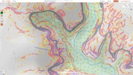
Going to be in Escalante area in spring with no particular plan other than to go explore some things - I don't do that often enough. Every hobby has a sub-hobby and one of mine is to just look at a topo and go see if routes that look like they should go actually do - very often they don't. Below is a map of something many here have done - Lower Calf Creek. I haven't been there since it became overrun with people - which is to say years - but lately I've gotten a little obsessed with the idea of getting above the falls and possibly even connecting a hike with Upper Calf Creek falls, but I've never heard of anyone doing it. The blue line on the map below looks like a possibility. Anyone ever tried this? I know the area reasonably well and I realize it would be very rugged up there even if it did go.
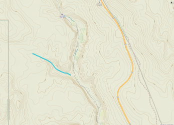
1675266839538.png
 
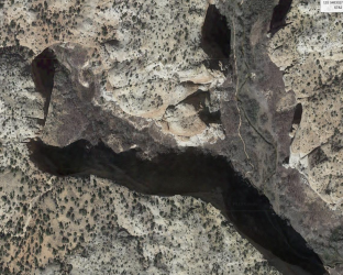
That branch looks like a pour-off in the sat view. It looks like there may be some more promising opportunities further south though.

Screen Shot 2023-02-01 at 10.22.32 AM.png
 
I've done a hike in this area from the west, that is so say from the McGath Point road, I think it's called. We route-found down to the creek not far below the upper falls, waded in the stream for a few hours, and then route-found back up from just above the lower falls. It was a delightful day. Doing this from the Highway 12 side would probably be easier and avoid some steep sandy patches on the road to the west. We did not try to access Calf Creek below the lower falls, no idea if that's feasible.
 
Hi @MikeP

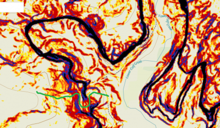
It looks like you are using Gaia GPS for your map. If you turn on the Slope Angle layer, it gives a good indication of slope steepness.

I had a quick look at the Calf Creek canyon and it appears to be almost completely ringed with a black stripe, using this layer; meaning almost vertically steep.

I did notice one small break in the stripe around here (37.81446, -111.41761), but it's anyone's guess from a mapping tool or satellite imaging, as to whether this would go. It might be fun to find out on the ground though :)

I have drawn a green line on the Gaia GPS map below to indicate the potential route.

BCP Calf Creek v1.png
 
I agree with @fossana, that area looks to be shear cliffs on all sides. A more likely exit (a least according to CalTopo's slope angle shading) might be found at: 37°48.868', -111°25.050'.
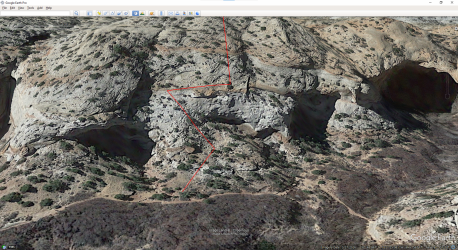
just looked at this in GE and I'd not count on it going, but it might.

looks like there's maybe some exits much closer to the trailhead though
 
Hope you take some sticky sole shoes ..... I didnt see any place that looked decent to climb up
 
Last edited:
I have explored off-trail around the lower and upper falls quite a bit. Hoping to be down that way in mid-March for a couple weeks of exploring and I was thinking about what you had planned as well. Even if you/I do not succeed in finding a route form lower to upper falls or upper to lower it would be a worthy adventure.
 
Even if you/I do not succeed in finding a route form lower to upper falls or upper to lower it would be a worthy adventure.
That's the way I see it as well. Does "Canadug" mean you're from Canada? Southern Utah and the Canadian Rockies are my two favorite places to hike. I have more trips lined up in those two places than I have time left in my useful hiking career.
 
If you are not wedded to the Lower Calf Creek Falls area, there is interesting extensive slickrock hiking in the upper falls and McGath Point area.
 
If you are not wedded to the Lower Calf Creek Falls area, there is interesting extensive slickrock hiking in the upper falls and McGath Point area.
ooops - screwed up somehow - trying again

McGath Pt from upper falls --- https://debravanwinegarden.blogspot.com/2014/12/mcgath-point-6759-via-upper-calf-creek.html --- if crossing above falls too dangerous, can circle ccw above where creek starts. When my wife & I did this hike, that is how we returned (obviously then circling CW to get back to the TH by Hwy12). That section is mostly slickrock.

McGath slickrock --- https://debravanwinegarden.blogspot.com/2020/05/mcgath-point-east-slickrock-region-peak.html --- I like a variation of this which is a slickrock circumnavigation of McGath Point - can do 6287 & 6400+ as a spur.

PM if you need more details or tracks but probably more fun just trying it on your own.
 
Thanks Writhdar. This is great info. Seems like a much more interesting way to get to McGath Point. I assume you did this as an out and back day hike.
 
Awesome, thanks. And I assume not too difficult? Reasonably intuitive?
 
Awesome, thanks. And I assume not too difficult? Reasonably intuitive?
I don't remember any difficulties at all. the streambed is slippery in spots. I suspect we entered Calf Creek just below the upper falls using the same route shown in the linked map. the McGath Point road has a nasty, sandy hill at one point that took us a few tries in a capable vehicle.
 
Similar threads
Thread starter Title Forum Replies Date
canadug Escalante area exploring Trip Planning 0
TrailScot Needles Exploring - March 2022 Hiking & Camping 6
kwc Exploring the past in the Southern Adirondacks Everything Else 1
Perry Day Hike Exploring the Wasatch Ridge Line Hiking & Camping 5
Yvonne Yellowstone 2018 - a solo trip hiking and exploring America's first National Park: Part II Madison Hiking & Camping 3
Yvonne Yellowstone 2018- A solo trip hiking and exploring America’s first National Park: Part I Mammoth Hiking & Camping 13
Perry Exploring above Cataract Basin - One of the Best Seats in the House Hiking & Camping 1
fossana Plan B Rainy Day Backyard Exploring Hiking & Camping 9
BryanG Exploring Southern Utah Trip Planning 15
hatchcanyon Exploring Southern Utah by Airplane Everything Else 20
Ross Invite: Exploring Little Colorado's north rim + Colorado East Rim viewpts Trip Planning 3
Scott Chandler Exploring Zion's Kolob Backpacking 5
IntrepidXJ Salt Creek Exploring & The Drive Home Hiking & Camping 3
IntrepidXJ Exploring the Arches Backcountry Hiking & Camping 0
Yvonne Exploring Horse Canyon, June 2010 Off Road 6
IntrepidXJ Exploring the Arches Backcountry Hiking & Camping 0
Yvonne Exploring the Swell, June 2011 Off Road 5
IntrepidXJ Exploring the Arches Backcountry Hiking & Camping 6
R Escalante River / Calf Creek Falls Current Conditions Trip Planning 10
BJett Day 1 - Upper Calf Creek Hiking & Camping 1
IntrepidXJ Upper Calf Creek Falls Hiking & Camping 0
IntrepidXJ Lower Calf Creek Falls Hiking & Camping 5
Udink Calf Mesa Hiking & Camping 9
Tyler Escalante: Peekaboo/Spooky gulch, Calf Creek Falls, and Hells Backbone Hiking & Camping 6
rinats Canyonlands/Needles: Salt Creek to Chesler Park Trip Planning 6
shredhiker Slough Creek mid June? Trip Planning 11
Spud Salt Creek Canyon question Trip Planning 11
BobFink Mirror Plateau via Pelican Valley and Pelican Creek, July / August 2023 Backpacking 12
Janice Such a GRAND Canyon - Deer Creek / Tapeats / Thunder River Backpacking 21
Jackson Little Rock Creek Backpacking 5
scatman Yellowstone's Thorofare, Headwaters of Thorofare Creek, Majo Pass, Younts Peak, Bob's Canyon, and Cub Creek - August 9, 2023 - Days 7 through 10 Backpacking 34
scatman Yellowstone's Thorofare, Headwaters of Thorofare Creek, Majo Pass, Younts Peak, Bob's Canyon, and Cub Creek - August 9, 2023 - Days 1 through 6 Backpacking 56
J South Crandall Creek and the Hoodoos Wyoming and Yellowstone? Trip Planning 3
CodyL Maple Creek or Duck Creek Drainages-YNP Trip Planning 0
J Pacific Creek or North Buffalo Fork? Teton Wilderness, Thorofare ,etc. Trip Planning 10
I Rescue Creek - Yellowstone National Park - June 3, 2023 Backpacking 15
Dreamer Slough Creek - YNP - 6/5-7/23 Backpacking 3
shredhiker Blacktail Creek June 2023 Backpacking 4
Dreamer Rescue Creek -YNP - 6/3-5/23 Backpacking 3
shredhiker Slough Creek May 2023 Backpacking 11
scatman Rescue Creek - Yellowstone National Park - June 3, 2023 Backpacking 56
Gretchen Millward Trachyte Creek via Woodruff Canyon, April 2023 Backpacking 9
I Slough Creek - Yellowstone June 5 & 6 Meet Up (Members Only) 19
scatman City Creek Loop - April 23, 2023 Hiking & Camping 8
F Thorofare/South Boundary/Wolverine Creek Trip Planning 2
scatman Rescue Creek - Yellowstone National Park Meet Up (Members Only) 19
Janice When might road to Salt Creek TH be ok? Trip Planning 23
BobFink Yellowstone South Entrance to Fox Creek via Basin Creek Cutoff - Labor Day 2022 Trip Reports 4
Janice Professor Creek / Mary Jane Canyon - mid April? Trip Planning 0
scatman North Ridge of City Creek Canyon - February 4, 2023 Hiking & Camping 17

Similar threads

Back
Top