Eric Robinson found at Allsop Lake

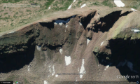
On Google Earth you can change back to older satellite images. They have a satellite image of the area from 9/14/11. There's still snow on Dead Horse Pass in the middle of September of that year. So maybe @Dan is right thinking there was too much snow on it in early August.

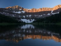
Deadhorse Pass from the Deadhorse Lake side
Capture.PNG
 
Thanks for the shout-out. This was a story I felt very motivated to write.
Thanks for putting together such a comprehensive story, pretty rare to see such quality and depth on stories like these nowadays. The insights from so many different sources are invaluable. Much appreciated.
 
On Google Earth you can change back to older satellite images. They have a satellite image of the area from 9/14/11. There's still snow on Dead Horse Pass in the middle of September of that year. So maybe @Dan is right thinking there was too much snow on it in early August.

Deadhorse Pass from the Deadhorse Lake side
View attachment 47897
Very interesting insight. I am sure there was tons of snow, I was at Allsop on August 12 and 13th of 2011, and the col closest to Yard peak was absolutely buried in snow still. McPheters was still mostly frozen even on July 24th when I was there that same year. Almost all of Middle Basin was still under snow the last week of July.

In talking to Duchesne, the sheriff mentioned he had a lot of trouble navigating snow on Anderson Pass. I wonder if that might have been why he got off route in Yellowstone, perhaps he had negotiated snow and not properly regained the trail? That would be super easy to do out in the head of Yellowstone, where it's almost all above treeline anyways, and you are looking for cairns most of the time. The more I've learned the less I'm inclined to think he made an accidental navigational error. I think it is possible the snow made him look for alternate routes. If Anderson was tough to cross, certainly Dead Horse would have been worse.

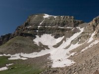
2011 Allsop.jpg
Allsop on August 12, 2011.

2011 Allsop-2.jpg
This is the col between Yard Peak, separating Allsop and Priord (similar aspect to Dead Horse) - August 13, 2011

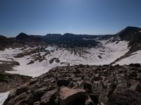
2011 Allsop-6.jpg
And this is Middle Basin from the ridge of Hayden Peak on July 23rd, 2011, only a few days before he started his hike. Check out McPheters, almost entirely covered in ice still.
 
Counterpoint - why would he intentionally head over into Allsop? There's nothing really over there - i.e. no trails that parallel the main Uinta crest. It's just another ridge between Allsop and Norice. If I were going to bail on Dead Horse Pass, I'd be headed downhill to West Fork Blacks Fork.

Now of course many of us know the range much better than an Australian, and it's certainly possible that he didn't have an overview map of the range with him, but wouldn't that make him less likely to head into high, steep terrain without a clear idea of where he was going?

If I had to guess, I'd say he mistook Allsop for Dead Horse. Dead Horse Pass looks absolutely nothing like a "pass", in the sense that it doesn't have a normal looking saddle point. And with a bunch of snow, it would have been even less recognizable.
 
Counterpoint - why would he intentionally head over into Allsop? There's nothing really over there - i.e. no trails that parallel the main Uinta crest. It's just another ridge between Allsop and Norice. If I were going to bail on Dead Horse Pass, I'd be headed downhill to West Fork Blacks Fork.

We talked about this quite a bit over the weekend and came up with a plausible reason. If he decided he needed to bail, that would mean a 10 mile hike down WFBF to an area that doesn't exactly see a lot of traffic. It's something like 30+ miles of dirt roads to get back to the highway, and that road crosses a pretty high pass. If you could sneak over into Allsop and bail out the East Fork Bear River drainage, you'd end up right at a Boy Scout camp and less than 7 miles from the highway. It could have seemed like a better choice for getting a ride out.
 
Counterpoint - why would he intentionally head over into Allsop? There's nothing really over there - i.e. no trails that parallel the main Uinta crest. It's just another ridge between Allsop and Norice. If I were going to bail on Dead Horse Pass, I'd be headed downhill to West Fork Blacks Fork.

Now of course many of us know the range much better than an Australian, and it's certainly possible that he didn't have an overview map of the range with him, but wouldn't that make him less likely to head into high, steep terrain without a clear idea of where he was going?

If I had to guess, I'd say he mistook Allsop for Dead Horse. Dead Horse Pass looks absolutely nothing like a "pass", in the sense that it doesn't have a normal looking saddle point. And with a bunch of snow, it would have been even less recognizable.

He had food for at least a few more days (based on how much food was in his pack at the scene). So the possibilities are endless - maybe he was going to bail out to East Fork Bear River, which is much closer to HWY 150 than WFBF to his pickup point? That would be a logical bail out for Highline hiker who didn't want to cross Dead Horse, in my opinion.

Next possibility would be Priord pass, but I think it would be unlikely he was headed there, since it is nearly identical to Dead Horse, but even less of a trail, and really requires crossing Yard or Cathedral pass as well, unless you walked all the way around. However, I can easily envision a scenario where I didn't want to cross Dead Horse, I looked at an overview map, (which he definitely had, as well as a GPS) and thinking it would be much easier to get back to the pickup location at Hayden Pass from EFBR rather than WFBF, especially if he had to hitch. With time on his side, maybe he wanted to see a few more days of scenery before bailing down to EFBR?

In the end, we really have no idea. It's all speculation. But I do think there is a valuable context here for those of us who spend a lot of time in the Uintas. Mostly, it's that there is a lot of off-trail routes that connect these drainages but they are not maintained and they can also hide some dangers that you might not be aware of if unfamiliar. The convex slopes on Allsop are a prime example. It's very possible he had no idea there were cliffs below him until he was right on top of them.
 
We talked about this quite a bit over the weekend and came up with a plausible reason. If he decided he needed to bail, that would mean a 10 mile hike down WFBF to an area that doesn't exactly see a lot of traffic. It's something like 30+ miles of dirt roads to get back to the highway, and that road crosses a pretty high pass. If you could sneak over into Allsop and bail out the East Fork Bear River drainage, you'd end up right at a Boy Scout camp and less than 7 miles from the highway. It could have seemed like a better choice for getting a ride out.
That scenario starts to make a bit of sense - it's certainly more direct to go via Allsop if you can get over the pass. It's not that much longer, maybe a couple miles, to go out to WFBF and then head west on the Bear River Smith Fork trail. Spits you out at the East Fork Bear River TH, same place that you'd get to via Allsop.
 
That scenario starts to make a bit of sense - it's certainly more direct to go via Allsop if you can get over the pass. It's not that much longer, maybe a couple miles, to go out to WFBF and then head west on the Bear River Smith Fork trail. Spits you out at the East Fork Bear River TH, same place that you'd get to via Allsop.

You're talking about the trail that crosses Deadman Pass between the WFBF trailhead and EFBR trailhead, right? That's more like 6 miles between the two according to @Jen and her recent trip that looped all of these places. Even if it were shorter, that would mean dropping a ton of elevation, then climbing back up it all. I could see the temptation to shortcut it to get closer to some civilization.
 
That scenario starts to make a bit of sense - it's certainly more direct to go via Allsop if you can get over the pass. It's not that much longer, maybe a couple miles, to go out to WFBF and then head west on the Bear River Smith Fork trail. Spits you out at the East Fork Bear River TH, same place that you'd get to via Allsop.

Agreed. Primary difference is quality of terrain you'd be in. One could form a plausible theory either way.

For a long time there has been a narrative that he was disoriented in Yellowstone, and it took a scout troop to get him back on the right track. I am not so sure that whole scenario is as cut and dry as it once appeared. He clearly was off-trail at that point, but it seems the snow impacted why he was off trail, and I'm not clear exactly where he was when he course corrected.

Most of Yellowstone is 25 miles away on foot, and he clearly navigated all the way to Dead Horse from his last known location. My gut tells me he was not just wandering around aimlessly like we had always presumed based on that news report. I think it's obvious the conditions caught him off guard, and he was out of his element to some degree, but he must have successfully navigated Tungsten, Porcupine, all of Oweep, Upper Lakefork, and Red Knob Pass successfully to get to Dead Horse. None of those areas are particularly tricky, but it does require a certain level of skill to get that far.

In reality, navigation is only part of the potential issues. Altitude can have devastating impacts as well, or possibly a variety of other ailments forced him that way. We really have no idea. I just feel like he was actually pretty prepared for this trip, even if he was solo, and historically he had proven himself to be a meticulous planner and fairly experienced.
 
Hi guys, just back in the frontcountry from the backcountry in the Windies for a couple of weeks to this jaw-dropping news. I want to weigh in a little without catching up with Dave's story and all your thoughts completely since I am checking back out for a week tomorrow. I will add thoughts by posts to break up my answers. I spent a lot of physical and mental energy on this as you will see.

First: I crossed Deadhorse Pass about August 14 - a full month later - doing the Highline from east to west. Snow was NOT an issue for me and my buddy Dan McCool. We already knew about Eric and were keeping an eye out for him. The bottom half of the pass was snow but the crux right-to-left crossing that gets above cliff bands was scree and mud and no big deal. I even remember a foot-printed route in the snow. I said YEAH on the snow and went vertical in it to make it faster.

We left Eric's Park City female friend at Deadhorse lake with her friend. We had spent the day hiking and walking with them after meeting them in Upper Lake Fork. They had been heli'd in by the sheriff to search.

Remember this was a full month later. During my crossing I had been impressed by how dry the range was. Although enough water to easily find and drink I think I did the full eight days without getting wet feet which is very unusual in my experience.
 
Last edited:
You weren't a month later @Artemus. The initial press release had some bad dates. Eric started his hike on July 28, 2011. He was seen in the Yellowstone drainage on August 2 and the search began on August 8, 2011.
 
The pass from Deadhorse Lake and into the East Fork of the Bear is well described by @Dan. In July of 2007 I went over the pass with friend Jeremy - just pokin' around as is my wont. Easy up the east and really more of a long saddle than a pass. We found a 6' high cairn that we then dismantled. Jeremy and I started looking around for a way down the west and split up. He went down the couloir directly and afterwards described it as no big deal. He is pretty tough though. I traversed north to a more rolled over scree descent and my crux was a cliff band of about 50' high with a steep chute in it that I bypassed on the cleaner rock on it's side. It was all crappy shale. I am pretty used to this terrain though.

Striking to me was in the 500' of bigger talus below I stumbled on the remains of a pack horse. Just a skeleton with a little hide and the pack saddle and some old debris. The animal had obviously fell and been left there years ago. No place for a cowboy or shepherd to have been taking a horse. No place for most backpackers to have been.
 
You weren't a month later @Artemus. The initial press release had some bad dates. Eric started his hike on July 28, 2011. He was seen in the Yellowstone drainage on August 2 and the search began on August 8, 2011.
I do remember him meeting up with that scout leader below Cleveland pass I believe and being pointed back to the Highline. I also remember his wife telling us that he had a PRB and NOT specifically a SPOT. I met her and his daughter a couple of times at the heliport below Moon Lake. The second time she was thanking me as I came out from my second search for him and she was flying in to leave a memorial for him in Upper Lake fork on the sheriff's last SAR flight. I greatly respect that they saved that last flight for her for that purpose.
 
Last edited:
As I finished my hike and met Eric's friend and exchanged contact info I committed to continuing the search after finishing my route. Dan and I weren't much good at that point being tired and low on provisions.

I still had some time off from work. I rested up a couple of days and contacted the sheriff in Duchesne. I drove over with full kit to the Moon Lake impromptu heliport and worked with his SAR deputies to work out a search grid. I had just walked the whole thing and my experience was invaluable to them. Seems they had pretty good experience in the low country/trailheads but really had no idea what was what in the high country. I let them know where the navigation challenges on the route were and he sent teams in on the highway patrol SAR helicopter.

They had been searching for quite a long time at this point and were basically overflying the problem spots a second time that I had outlined.
 
Last edited:
Back
Top