Cuberant Lake, June 16 2012

Dave

Broadcaster, formerly "ashergrey"
.
Joined
May 5, 2012
Messages
1,725
High-elevation hiking in the Uintas in mid-June... not something one can do every year. This quick out-and-back trip meant to capitalize on that.

nick and a co-worker of mine both put the story of Garrett Bardsley back in my head, independent of one another. I'd covered the story when it originally happened and it, along with the deaths of Carole Weatherton and Kim Beverly, are two great mysteries of the area.

Having never been to the Cuberant Basin myself, it seemed as good a target as any for a day hike.

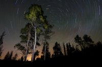
I drove out to the north slope on Friday night after work. Arriving late, I set up for a night sky shot (taking advantage of the moonless sky) before heading off to bed.


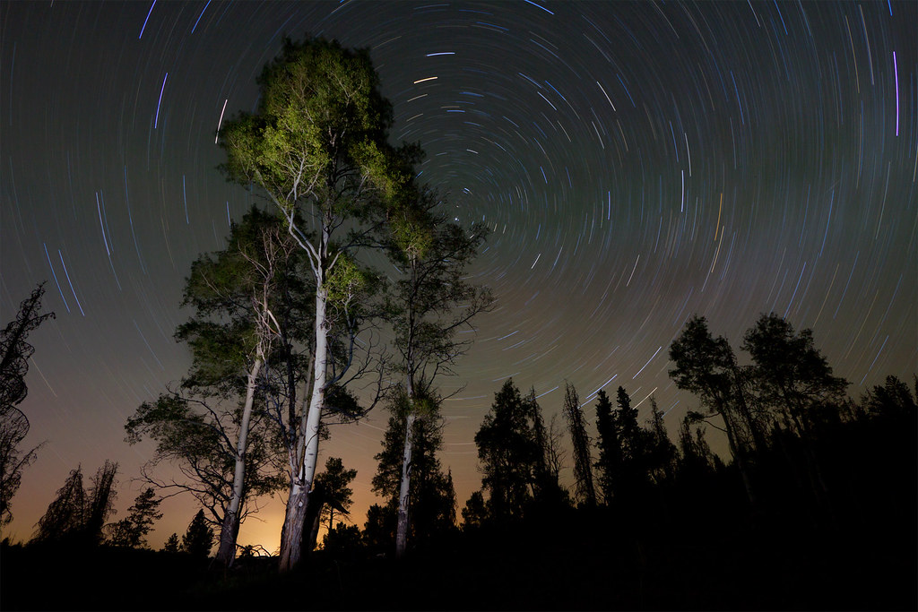
In the Meadow by ashergrey, on Flickr

Morning came quick. I made it on trail by about 8 a.m., round about the same time Garrett disappeared. There were only two other vehicles in the Pass Lake Trailhead lot and I passed no one on my hike in to the basin.

This trail, which later splits and also serves the Kamas/Lofty Lake Loop, crosses the edge of a beautiful space called Reid's Meadow. This is the headwaters of the Main Fork of the Weber River. It provides a commanding view of 11,708-foot Reid's Peak due south.

Reidflection.jpg


Hiking by ashergrey, on Flickr

Beyond the meadow the trail ambles along to the southern base of 11,340-foot Mount Marsell. It skirts along the lower slope of Marsell as it climbs and then drops into the Cuberant basin.

As near as I can tell from eight-year-old media reports, Kevin and Garrett Bardsley were fishing on the bank of Cuberant #1 when he soaked his shoes and socks.


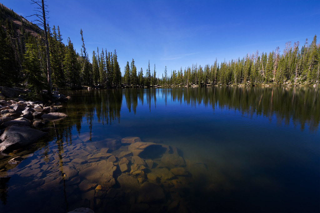
Cuberant 1 by ashergrey, on Flickr

The rest of their Boy Scout/Deacon's Quorum group were camped just up the hill at Cuberant #4.


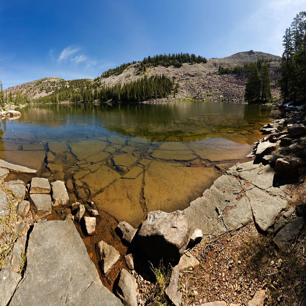
Cuberant 4 by ashergrey, on Flickr

The trail between the lakes is short but much more faint than the trail leading into the basin. This shows the rough location of the trail in relation to the lakes.

Path.jpg

It roughly follows the outlet from Cuberant #4 that at times flows down into #1. Kevin Bardsley has said that he saw Garrett miss the trail. The father called out to his son and pointed out the mistake. Garrett then head up into the trees and was never seen again.

The terrain is wooded and rocky and from within the trees it can be hard to get one's bearings. The slopes of Marsell rise sharply on the east but the west-southwestern horizon opens into a wide expanse of the Middle Fork of the Weber. Did Garrett get lost and wander aimlessly in that direction?

I'm not so sure. Even a 12-year-old could recognize after 30 minutes to an hour of wandering that he was hopelessly lost when the walk should have taken two or three minutes tops. Because the basin is an amphitheater, sound carries very well. Calling out from within a quarter to half mile of camp could have roused the troops.

Garrett's story bothers me even more now that I've scoped out the terrain. There are plenty of possible scenarios, from loss to injury to abduction to animal attack... but none really seem to jibe for me.

In any case, I headed up to Cuberant #4, circled around to its eastern edge and then started up the boulder field.

Sign.jpg

Path above Cuberant.jpg

Looking Back.jpg

From here travel is cross-country, with no trail. The boulders eventually lessen and one can pick a path over wide open meadows. In June, the grasses and flowers were still matted from the recently melted snowpack. I continued up this slope until reaching the saddle dividing the Cuberant Basin from the Hayden Fork drainage. The saddle is just below 11,000 feet above sea level, about 300 feet below Mount Marsell.

The saddle's eastern side drops in steep cliffs, the tops of which were still frosted with snow. To only find snow like this in mid-June is nearly unheard of. And it was warm, even at elevation... very strange. I took a step or two onto the snow and found it very soft. Fearing it might be corniced, I kept my distance from the edge.

Cornice.jpg

That's Hayden Peak on the right and Kletting Peak on the left. The two lakes below are Cutthroat on the right and Teal on the left. Lofty Peak is at the far right and Lofty Lake is just out of frame.

From here the ascent to the top of Marsell is a steady ramp, not too boulder heavy. I vacillated about making a summit push but ended up turning back due to time constraints. My sister and I had also hiked to Scout Peak a few years earlier. Scout is a couple hundred feet shorter than Marsell but offers similar views, so I knew what I'd miss by skipping the peak. This was as close as I came.

Mount Marsell.jpg

On the way back down I picked a different line in an effort to avoid a lot of the boulder hopping. This kind of worked and kind of didn't. While I did skip plenty of bouldering, the bouldering I did end up doing was across much steeper areas. This significantly slowed my progress.

Boulder Chutes.jpg

Hikers headed out of Cuberant Basin get a fantastic view of Reid's and Bald Mountain.

Reids and Bald.jpg

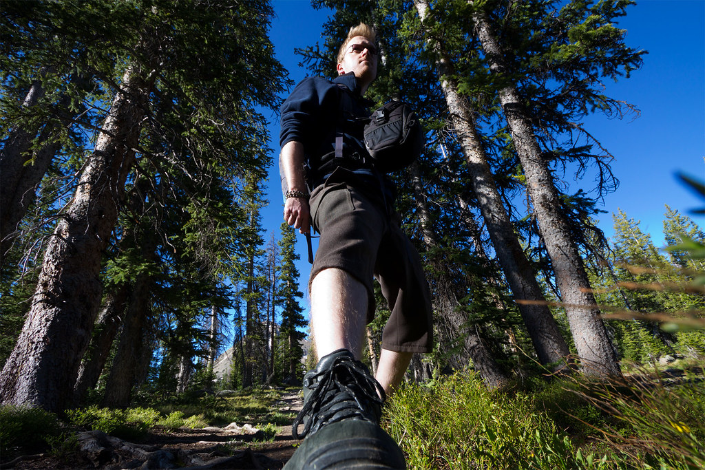
I made it back to the car before 2 p.m. which was my goal. Obligatory self-portrait:

Self 2.jpg

[PARSEHTML]<iframe src="http://www.mappingsupport.com/p/gmap4.php?q=http://dl.dropbox.com/u/3847512/GPS/Cuberant_LakeMarsell.kml&t=t4" frameborder="0" marginheight="0" scrolling="no" width="800" height="800"></iframe>[/PARSEHTML]
 

Attachments

  • slide.jpg
    slide.jpg
    187.4 KB · Views: 1,363
Great shots. Looks like a great hike. I can't believe that there is that little of snow up there this year. What an extreme difference from the year before.
 
I was camped just down the road a few miles this past weekend.
 
Nice shots. And I totally agree. After being out there Garret's disappearance seem even more baffling. Looks like a fun side trip up to that ridge though. Can't wait to get out into the mountains.

Two minor corrections... Reid's Meadow is actually at the head of the main fork Weber River. The Middle Fork is the one south of Holiday Park, main is SE. And you've got Teal and Cutthroat switched. It's Teal on the left, Cutthroat on the Right. ;)

Bah, I knew that about the lakes, I just reversed them. I'll make a fix.
 
I have a couple of corrections about the Garrett Bardsley disappearance. I was camped at Cuberant #4 when Garrett went missing and spent the day helping to look for him. His group was actually camped in the meadow just up from Cuberant #2 (between #1 and #2). This is the meadow you pass by just after going over the pass and dropping down into the Cuberant basin. He and his father Kevin had been fishing at Cuberant #2 that morning. Up at Cuberant #4 we could hear members of his group yelling his name that morning he went missing. You are correct about how the sound carries up there in the basin. A little bit later a member of their group came up to #4 on horseback asking if we'd seen him. After that we decided to spend that day helping to look for him. That night we spent up there after he disappeared was one of the most awful nights of my life, knowing that poor kid was out there in the cold while I was safe and warm in my sleeping bag. I went back up the next week to spend another day searching. It bothers me to this day. I'm headed up there to go backpacking with my boys this coming weekend.
 
The discussion on the Kim & Carole thread got this one going in my head again.

In looking at the satellite images and the topo map it looks, not probable, but
possible that the one could follow the lines I've shown on the following image.
image.jpeg

For those that have been there, are those lines of travel possible?

It seems baffling that someone could disappear so completely in such a small area. So I was
examining how does one leave the basin without going out the way you come in.
 
For those that have been there, are those lines of travel possible?

Possible perhaps, but extremely unlikely in this circumstance. The drop off into the Main Fork of the Weber is steep and cliffy. The way up would be a boulder hop. I revisited Cuberant earlier this summer and have some new thoughts on this situation. I'll post them eventually.
 
A rock slide could've occurred while Garrett was hiking around. Perhaps that would be a good place to search for his remains?
 
The discussion on the Kim & Carole thread got this one going in my head again.

In looking at the satellite images and the topo map it looks, not probable, but
possible that the one could follow the lines I've shown on the following image.
View attachment 46828

For those that have been there, are those lines of travel possible?

It seems baffling that someone could disappear so completely in such a small area. So I was
examining how does one leave the basin without going out the way you come in.

Perhaps Garrett did travel one of those routes and was covered by a rock slide?
 
I have a couple of corrections about the Garrett Bardsley disappearance. I was camped at Cuberant #4 when Garrett went missing and spent the day helping to look for him. His group was actually camped in the meadow just up from Cuberant #2 (between #1 and #2). This is the meadow you pass by just after going over the pass and dropping down into the Cuberant basin. He and his father Kevin had been fishing at Cuberant #2 that morning. Up at Cuberant #4 we could hear members of his group yelling his name that morning he went missing. You are correct about how the sound carries up there in the basin. A little bit later a member of their group came up to #4 on horseback asking if we'd seen him. After that we decided to spend that day helping to look for him. That night we spent up there after he disappeared was one of the most awful nights of my life, knowing that poor kid was out there in the cold while I was safe and warm in my sleeping bag. I went back up the next week to spend another day searching. It bothers me to this day. I'm headed up there to go backpacking with my boys this coming weekend.

I have always wanted to know where they camped. I have walked by that meadow every year since 2009. I know it well. Kind of a crappy place to camp in my opinion. Heading up to #4 or down to #3 would have been better camping.

According to the S&R they found his sock in a boulder field 1/4 mile from where he was last seen. His Mom positively identified the sock as belonging to Garrett. That was the only thing ever found of Garrett Bardsley. It would be hard to imagine anyone abducting him and trying to leave that basin over the pass with a kid that big.

I have a friend who's best buddy was part of the S&R out there. They to this day are puzzled on what happened to him. They said they combed every inch of that basin and he was never found. With all the strange stuff I have experienced in that basin, makes you wonder if it is all connected somehow. Spooky to say the least.
 
Man...poor kid..vanished. Dr Nebz what kind of strange things have you experienced in the basin? The area looks great..I plan on hiking there soon. Finished reading a "Missing 411" book...spooky stuff.
 
Dr Nebz what kind of strange things have you experienced in the basin? The area looks great..I plan on hiking there soon. Finished reading a "Missing 411" book...spooky stuff.

I posted a readers digest version of events here: http://backcountrypost.com/threads/...tales-of-the-unusual-in-the-woods.4090/page-7

There were more details, and weird things, but this gives a summary without reading a novel.

Yeah, the disappearance out at Island Lake by Hoop Lake and Kabell Lakes was another one that was freaky in that book. Like I said before, you can claim nothing is going on out there, its kind of hard to discount missing persons cases. They were real and vanished. Kind of hard to fake that, especially the small children found so far away from where they disappeared.
 
Has anyone ever done a public records request for this search? Do they have GPS cords for where the sock was found? I've been following this search ever since it happened, and with the resent talk in the other thread it has peaked my interest again.
 
I was sad Nick shut that thread down. I thought it was one of the more unique and interesting threads on this sight.


Sent from my iPhone using Tapatalk Pro
 
Wow, bringing back one from the archives.

For the record, I've done several outings to Cuberant since this 2012 hike and my perspectives on the Garrett situation have evolved. The other thread had gone off topic, which is why it got shut down. Ultimately, none of us can definitively say what happened to Garrett.

I've never heard that the location of the sock was pinpointed by GPS coordinates, but it's possible. However, there were reports from the time questioning if the sock even belonged to Garrett.

And if @j_crunch ever comes back to this site, I'd love to get in touch.
 
The discussion on the Kim & Carole thread got this one going in my head again.

In looking at the satellite images and the topo map it looks, not probable, but
possible that the one could follow the lines I've shown on the following image.
View attachment 46828

For those that have been there, are those lines of travel possible?

It seems baffling that someone could disappear so completely in such a small area. So I was
examining how does one leave the basin without going out the way you come in.
I was camping with my Girl Scouts in the High Uintas near Vernal, UT same weekend Garrett was lost while camping. The following week, I felt compelled, called actually, to drive 3.5 hours and go searching to recover Garrett Bardsley. I had a vision of him at the top of a boulder field, where he'd crawled into a shallow, narrow shelter below a boulder, head and shoulders first, with only the white soles of his tennis shoes protruding. He'd climbed up high and when night fell, had done what he could to protect himself for the night. Just a thing that a frightened, lost, naive Boy Scout would do. Never having experienced a calling like that, I felt it was my job to follow it.

My co-leader, Rush, joined me for a two night backpack trip the weekend following Garrett's disappearance. Rush had done her masters thesis in wildlife studies tracking elk migration across the Uintas. As part of her work, she was dropped by helicopter into the Uintas, where she tracked the radio-collared elk and hiked her way out. She was a very good tracker. I am someone who can get lost in a paper bag. My plan was to visit Garrett's camp, walk the trail to the fishing spot, then "become Garrett" and walk back to camp alone, thoughtlessly, daydreaming, as I (and I believed Garett) tend to do. Rush's job was to follow me.

Upon arriving at the trailhead, we saw a van signed as Garrett's search headquarters. Inside was just one guy, and we introduced ourselves, asking if he could give us directions to the camp and the fishing lake. Indeed he could, he said, as he was Garrett's Dad. Then, I told him I believed Garrett had gone high to get a perspective before night fell (I wish in retrospect I'd said I had a vision, but was embarrassed to do so; what if I was wrong?) Mr. Bardsley rejected outright the idea that Garrett had gone high. The search, he said, was now focused downhill, as a sock had been found and it was believed he would naturally take the path of least resistance. my heart fell. They were thinking the wrong way. We were on our own. But we had an amazing start. We had immediately happened onto Mr. Bardsley, who directed us to exactly where to begin. So that is what we did.

We were out two days and nights and Rush was game to just follow around this idiot until I dropped. Yet, I didn't quite connect with Garrett, as I thought I would. I grew frustrated and that distracted me from getting properly lost. Rush remained on task, but I felt her impatience. She was too close to me, a distraction. I needed to get lost alone, panic alone, and believe myself lost. Maybe I needed a radio collar myself, with no one really following me.

We departed late the second day, unsuccessful. The weather had changed; a storm was coming, and the snow was beginning to fall. Mr Bardsley was still there, closing up the van, preparing to get off the mountain before the storm. We checked in with him to say goodby. He wasn't surprised we'd been unsuccessful; we were just like so many others who had been searching for more than a week now. Yet, I still knew that I could find him, if I just had more time, and if Rush had more time, and if she could believe in it as I did, and the weather would cooperate..... The feeling did not leave me.

The following week I was back with my co-leader Loran and another friend. The search van was no longer there. We would be camping only one night, due to time constraints and we would be car-camping, which was all the friends' were physically and materially equipped for. We did not get far. The friends could not keep up with me running and scrambling over boulders, nor were they good trackers or equipped with GPS. They were well meaning, middle aged ladies. But, I got far enough ahead that I DID get lost, frightened, and panicked, and did ALMOST use my whistle to summon them, only to have them quickly find me. We were not so far separated a I'd thought. Yet, this second experience confirmed for me that I could "be Garrett", if I only had the time, and enough support. I believe I understood how Garrett felt; he was too embarrassed to yell for help, until he was too far away to be heard.

After this trip, strangely, I did not feel dejected. Although I had failed to find Garrett, there was a new calming message in my head saying to me if Garrett wanted me to find him, I would have. I left the mountain that day feeling that one day, under other circumstances, if/when Garrett is ready to be found, more importantly, if/when he and his family are ready to shoulder the grief of such a reunion, THEN I will be called to go out again. I still know I can find him. I'm fifteen years older now; my daughters are raised and college graduated. I've retired, and have no time constraints. So, I'm putting this story out there, however woo-woo it might sound to some (or many). Perhaps through telling this story, I will meet up with a receptive Mr Bardsley. Or perhaps it will be some hardy outdoorsmen/outdoorswomen/ who feel as compelled and certain, as I have felt all these years, that this boy will be found.
 
Never having experienced a calling like that, I felt it was my job to follow it.

Thank you for sharing your story. Those kinds of feelings can be very strong. I’m sure it took a toll on you to invest the effort searching but come away empty handed. I hope the experience provided insightful.
 
Last edited:
I had a vision of him at the top of a boulder field, where he'd crawled into a shallow, narrow shelter below a boulder, head, and shoulders first, with only the white soles of his tennis shoes protruding.
I met Kevin Bardsley (Garrett's father) a few years ago and he told me this is what he believes Garrett did - got himself into some sheltered spot. This is why he believes that Garrett's remains have never been found.

I would love to know what lake they were fishing at and where they were camped.
In my personal research into this topic, I've read several conflicting info, so I have
nothing definitive.

@DrNed
As I mentioned above, I was there camped at Cuberant Lake #4 (the big one). My friends and I helped search from mid morning until it got dark on the day he got lost. We didn't speak directly with Kevin Bardsley but we spoke with some of the other adult leaders in the group. We assisted the first responders from the SAR in an organized sweep around their camp late that first afternoon. I can say definitively that what I indicated in my previous comment is true. Feel free to message me directly with any questions and I'll do my best to answer them.
 
Similar threads
Thread starter Title Forum Replies Date
Tomaswmitchell Cuberant Lake hike, Bigfoot tracks? Video Hiking & Camping 2
Blake Merrell Cuberant, Mt Marsell, Kamas, Lofty Lake loop LIVE Backpacking 0
Perry Cuberant Basin On Sunday - Need Some Advice and a Plan B Trip Planning 6
Hoobie Mystery "trail" Above Cuberant Basin? General Discussion 29
Blake Merrell Cuberant, Kamas & Lofty with a little Mount Marsell Backpacking 18
DrNed Day Hike Into Cuberant Basin - And Hopefully A Visit With Sasquatch Trip Planning 1
Thomas Rasmuson Cuberant Lakes 2013 Backpacking 4
Nick Cuberant Lakes Basin, Uintas Backpacking 4
scatman Grebe Lake - September 4th through the 6th, 2024 Meet Up (Members Only) 20
K How long in Lake Bled? Trip Planning 1
wsp_scott Yellowstone Lake to Brooks Lake (Aug 2023) Backpacking 16
Mikjik86 Backpacking Indian Peaks Wilderness - King Lake - August, 2023 Backpacking 0
Ugly Two Popular Lake Basins in the Cascades Backpacking 12
TheMountainRabbit Ortenburger Lake, Talus Lake, & Glacier Peak (Grand Teton NP) - October 2023 Backpacking 14
kwc Fall hike to Chase Lake, Southern Adirondacks Hiking & Camping 1
TrektheWorld Red Deer Lake & Beyond Backpacking 10
shredhiker Thorofare, Heart Lake, Snake River Sept. 2023 Backpacking 16
Bob Wind Rivers - Short Trip to Cook Lake Trip Reports 9
regehr (Uintas) Lake Fork Fun Backpacking 8
Timber High Sierra - North Lake to South Lake Loop - Layover Day Trip Planning 9
kwc Limekiln Lake paddle On The Water 0
shredhiker YNP Fawn Pass to Sportsman, Crescent, Shelf Lake Backpacking 11
Bob The Thorofare to Brooks Lake - 9 Days in Pictures Backpacking 10
Janice Lizard Head Plateau - overlook Upper Cathedral Lake? Trip Planning 15
uintafly Chepeta Lake to Hayden Pass Trip Planning 0
DrNed Naturalist Basin: Blue Lake to Shaler Lake? Trip Planning 12
shredhiker YNP Fawn Pass to Sportsman & Crescent Lake Trip Planning 14
kwc Jockeybush Lake- southern Adirondacks Hiking & Camping 0
shredhiker Yellowstone Heart Lake September 2022 Backpacking 9
TheMountainRabbit Black Lake (Rocky Mountain NP) - January 2023 Hiking & Camping 3
Ross Any Lake Powell experts who can advice on changed conditions at dramatically new lake levels? Trip Planning 3
NorthwestWanderer Backpacking Grand Teton National Park : Fossil Pass,Fox Creek Pass,Indian Lake,Alaska Basin,Hurricane Pass,Ice Floe Lake,& Snowdrift Lake Backpacking 19
NorthwestWanderer 8 Day High Sierra trek : Humphreys Basin, Star Col, Granite Park, Lake Italy & Piute Canyon 6/25-7/2/22 Backpacking 7
TractorDoc Yellowstone's Wrangler Lake, Bog Creek, Joseph's Coat Springs, Broad Creek, Wapiti Lake, Hot Springs Basin, and Pelican Valley. The Second Half. Backpacking 15
kwc Another Southern Adirondacks hike - Clockmill Pond and Rock Lake Hiking & Camping 0
TractorDoc Yellowstone's Wrangler Lake, Bog Creek, Joseph's Coat Springs, Broad Creek, Wapiti Lake, Hot Springs Basin, and Pelican Valley. Part One of Two. Backpacking 61
kwc Round Lake, north central Adirondacks, in the Round Lake Wilderness On The Water 2
Jackson Heart Lake and Snake River for Labor Day Backpacking 23
scatman Pacific Creek, Moss Lake and Gravel Lake - Teton Wilderness - October 7, 2022 Backpacking 32
TractorDoc Yellowstone's Hayden Valley, Trout Creek, Beach Lake, and Arnica Creek Meadows. September 11, 2022. Hiking & Camping 7
balzaccom Obata Lake...xc in Yosemite Backpacking 0
scatman Grizzly Lake - September 7, 2022 Backpacking 31
P Yellowstone, one night by a lake Backpacking 19
kwc A Few More Photos from Scatman’s Grizzly Lake trip … Backpacking 3
P Scatman's Grizzly Lake hike, 2022 Backpacking 28
P Yellowstone--Heart Lake to South Entrance Backpacking 13
scatman Shoshone Lake Lollipop Loop - Yellowstone National Park - July 24, 2022 Backpacking 63
T How big are the Mirror Lake campgrounds in the Porkies? Trip Planning 6
Georgia Yankee Apostle Islands, Lake Superior (again), June 2022 On The Water 4
kwc Adirondack Hike to Middle Lake Hiking & Camping 0

Similar threads

Back
Top