fossana
Member
- Joined
- Jan 11, 2018
- Messages
- 1,081
Feeling sickly but not wanting waste a sunny winter weekend, I decided to do some local backcountry exploration in the adjacent Cottonwood Forest Wilderness and Cottonwood Canyon Wilderness areas.
Day 1. Leeds Peak+
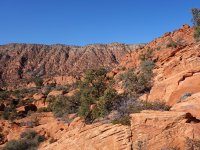
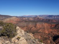
During my Dick's Canyon ramble back in October, I made a mental note about returning to explore Leeds Peak from the steep (eastern side). I returned on a January Saturday (12 Jan 2019) to check it out.

To make things more interesting I picked a scrambling line through the lower cliff band instead of approaching from the Silver Rim trail (not shown on the map).

The route conveniently intersected the Silver Rim trail near the saddle. I followed the old Jeep road down into the basin until I picked up a drainage heading toward Leeds Peak.


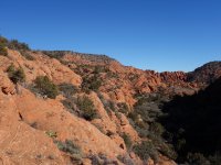
I exited the drainage at a pour-off and looked for a probable route up Leeds Peak. My original plan was to head up the obvious sandstone rib that led directly to the summit, but as I got closer the bottom of the rib it looked steeper than I wanted to attempt on damp sandstone. I decided to leave the south side of the rib for a future trip once the rock had dried, and headed up the rocky slope just to the north.


The route was uneventful, and soon I was on the summit. There was intermittent snow on the shadier aspects and I ran the summit ridge until almost to the Forest Service road. I encountered a lone cairn, indicating the normal route up this infrequented peak. Just after the last ridge bump I cut to the east paralleling the road in the drainage to avoid the cars and 4x4s on the road above.


Once back on the FS road I quickly filled my monthly bag of public lands trash and recyclables (2019 goal) and completed my loop.

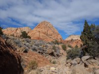
Day 2. Heath Wash Yant Flat Recon
Sunday was windier and colder than forecast, so I wasn't in a hurry to leave the house. In preparation for a future Cottonwood Canyon/Yant Flat/Heath Wash lollipop loop on a warmer day with more daylight my goal was to scout out a Heath Wash exit from Yant Flat.

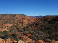
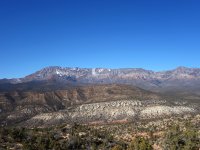
Being a chilly Sunday, the trailhead was fairly quiet. As always the views from the trailhead into Cottonwood Canyon were expansive, but the snow in the Pine Valley Mountains made it even more dramatic.

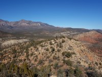
Once in the wash proper, the walking was somewhat tedious with the amount of rocks, but the views and damp sand made it less of a slog.


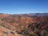
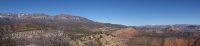
Soon after the Heath Wash junction the surrounding formations increased in height and the dramatic striped cliffs surrounding Yant Flat (a.k.a. Candy Cliffs) came into view.


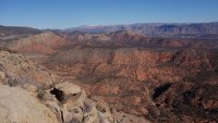
While one or two maybe routes into Yant Flat appeared, the canyon just before the Big Hollow narrows seems like the most obvious choice from the topo and the easiest one to find if coming from Cottonwood Canyon. There were a few minor pour-offs, but the route checked out.


On the way out I encountered the lone wildflower of the day. The clouds rolled in and the temperature dropped significantly on the way out. All in all, the excursion was not so great for my cold, but satisfying from an exploratory perspective.


Day 1. Leeds Peak+
During my Dick's Canyon ramble back in October, I made a mental note about returning to explore Leeds Peak from the steep (eastern side). I returned on a January Saturday (12 Jan 2019) to check it out.
To make things more interesting I picked a scrambling line through the lower cliff band instead of approaching from the Silver Rim trail (not shown on the map).
The route conveniently intersected the Silver Rim trail near the saddle. I followed the old Jeep road down into the basin until I picked up a drainage heading toward Leeds Peak.
I exited the drainage at a pour-off and looked for a probable route up Leeds Peak. My original plan was to head up the obvious sandstone rib that led directly to the summit, but as I got closer the bottom of the rib it looked steeper than I wanted to attempt on damp sandstone. I decided to leave the south side of the rib for a future trip once the rock had dried, and headed up the rocky slope just to the north.
The route was uneventful, and soon I was on the summit. There was intermittent snow on the shadier aspects and I ran the summit ridge until almost to the Forest Service road. I encountered a lone cairn, indicating the normal route up this infrequented peak. Just after the last ridge bump I cut to the east paralleling the road in the drainage to avoid the cars and 4x4s on the road above.
Once back on the FS road I quickly filled my monthly bag of public lands trash and recyclables (2019 goal) and completed my loop.
Day 2. Heath Wash Yant Flat Recon
Sunday was windier and colder than forecast, so I wasn't in a hurry to leave the house. In preparation for a future Cottonwood Canyon/Yant Flat/Heath Wash lollipop loop on a warmer day with more daylight my goal was to scout out a Heath Wash exit from Yant Flat.
Being a chilly Sunday, the trailhead was fairly quiet. As always the views from the trailhead into Cottonwood Canyon were expansive, but the snow in the Pine Valley Mountains made it even more dramatic.
Once in the wash proper, the walking was somewhat tedious with the amount of rocks, but the views and damp sand made it less of a slog.
Soon after the Heath Wash junction the surrounding formations increased in height and the dramatic striped cliffs surrounding Yant Flat (a.k.a. Candy Cliffs) came into view.
While one or two maybe routes into Yant Flat appeared, the canyon just before the Big Hollow narrows seems like the most obvious choice from the topo and the easiest one to find if coming from Cottonwood Canyon. There were a few minor pour-offs, but the route checked out.
On the way out I encountered the lone wildflower of the day. The clouds rolled in and the temperature dropped significantly on the way out. All in all, the excursion was not so great for my cold, but satisfying from an exploratory perspective.
Attachments
-
 DSC09279.jpg602 KB · Views: 27
 -
 DSC09285.jpg2 MB · Views: 25
 -
 DSC09288.jpg2.1 MB · Views: 25
 -
 DSC09294.jpg1.8 MB · Views: 26
 -
 DSC09307.jpg429.5 KB · Views: 27
 -
 DSC09310.jpg124.4 KB · Views: 28
 -
 DSC09312.jpg383.8 KB · Views: 26
 -
 DSC09317.jpg1.8 MB · Views: 26
 -
 DSC09319.jpg2.2 MB · Views: 24
 -
 DSC09385.jpg2 MB · Views: 25
