Continuing Adventures in Eastern Zion National Park

When we went in for a backcountry permit into this zone (Kolob Ranger Station) the rangers said they had never issued one before that they were aware of. Our original plan was to finish the Cross Zion trek from Weeping Rock, across the East Rim. Then extend it to the Barracks, cross the river and up across Shunes Hollow to the white knolls and Canaan Mtn. Then descend past Eagle Crags and shuttle back the the visitor center parking. We planned 6 days.
Weeping rock was closed because of rock fall so we opted to just do three nights in the southeast canyons area and drive around to Canaan Wilderness for 3 more.
Why I mention this is that the rangers told us they prefer if we don't put it on the net because it is a bit unknown still. Which is one of the reasons I am rethinking about what I post, where, and why I am doing it.
Ironically, East Fork Virgin River was raging and we couldn't safely even go through the Barracks, let alone go 2.5 miles upstream to the first south side exit. We got lucky not having to turn around and hitch back to the visitor center.

Well said.
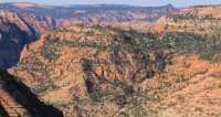
So from where the first photo was taken... for what I remember the west to east across that area would be a route finding adventure- Kudos, and then the idea of tying all of those together. Sweet! Sad that you were not able to fully connect them together.

We used to spend time in those parts, plus the parts north, and then cool off in the afternoon in the pools outside the tunnel at Pine Creek. Used to rarely see a soul. I should take my kids to experience what I did out there even if there are a few more people.
 
Indeed, Zionsky. Just coming off the top heading north.
Nice! I observed this area from the top of roof peak and thought about exploring it further next time I'm out there. Did you access via Gifford? I've seen limited beta on the exit route.
 
Nice! I observed this area from the top of roof peak and thought about exploring it further next time I'm out there. Did you access via Gifford? I've seen limited beta on the exit route.

From the other side. The bowl shaped drainage to the E/NE of Little Jenny that drains into Crawford Wash just before it falls off into the Parunaweep. 80 foot contours deceive! There were several dryfalls to bypass on slabby or ocassionally brushy Class 3. I have wanted to complete a traverse of the southside with a multiday pack but was glad to not be carrying one up that side draw.
 
From the other side. The bowl shaped drainage to the E/NE of Little Jenny that drains into Crawford Wash just before it falls off into the Parunaweep. 80 foot contours deceive! There were several dryfalls to bypass on slabby or ocassionally brushy Class 3. I have wanted to complete a traverse of the southside with a multiday pack but was glad to not be carrying one up that side draw.
I never paid much attention to the east side as I thought the walls from Crawford wash were too vertical but I see that bowl now after looking at google earth. Kind of gives me an idea for a Separation/Gifford loop.
 
I never paid much attention to the east side as I thought the walls from Crawford wash were too vertical but I see that bowl now after looking at google earth. Kind of gives me an idea for a Separation/Gifford loop.
It has taken me awhile to get comfortable that the area you and @John Morrow are discussing is south of the closed Wilderness Study Area.....but I believe it is okay
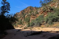
. Here are a couple pictures I took in 2015. The first shot is the bowl that gets you to Little Jenny (I believe). The 2nd shot is a potential weak spot in the cliff wall taken within Crawford Wash.....which might lead to this bowl(?) All my other shots within the narrow wash show quite a high vertical wall. In a trip report of @fossana she accessed the area from Gifford.
IMG_2360.jpgIMG_2385.jpg
 
Last edited:
It has taken me awhile to get comfortable that the area you and @John Morrow are discussing is south of the closed Wilderness Study Area.....but I believe it is okay
. Here are a couple pictures I took in 2015. The first shot is the bowl that gets you to Little Jenny (I believe). The 2nd shot is a potential weak spot in the cliff wall taken within Crawford Wash.....which might lead to this bowl(?) All my other shots within the narrow wash show quite a high vertical wall. In a trip report of @fossana she accessed the area from Gifford.
View attachment 78295View attachment 78296

Hi chandlerwest. Indeed outside the RNA boundary. Your second pic of the wash shows the bowl up and right like you surmised. We did not like that direct route in. The bowl spills out in a dryfall into Crawford just downcanyon from the pic. We went further downcanyon, found a quick and easy gully scramble up to a ledge/shelf. We then took the shelf back into the bowl draw. Above that we were forced out three times due to dryfalls or too steep friction slab. Exited right, then regained the wash and immediately went left through steep brush, cross again back right up a slickrock slope and diagonaled back to the center of the bedrock drainage which had a moderate angle inside corner to climb along. Then an easy walk to the final Class 2 east slope of Little Jenny. South on the ridge from Little Jenny was an incredible view of the Parunaweep.
John
Just great.........another potential place to get to......ha. I have done 3 ridge walks out to overlooks looking down to the river in the Parunuweep area. All were lifetime high points! Oh those "too steep friction slabs." They appear harmless/doable with the right combination of speed and friction and balance. But you just can't ignore the air that they suck out of you just by looking at them.
 
Just great.........another potential place to get to......ha. I have done 3 ridge walks out to overlooks looking down to the river in the Parunuweep area. All were lifetime high points! Oh those "too steep friction slabs." They appear harmless/doable with the right combination of speed and friction and balance. But you just can't ignore the air that they suck out of you just by looking at them.
Sounds like you'll enjoy the scrambling just fine. Personally, though, i would't want an overnight pack on it. We didn't give it much concern and there could be better routes around the dryfalls. Have fun with it!
 
Similar threads
Thread starter Title Forum Replies Date
OldBill (mis)Adventures in and around the Winds Backpacking 8
chandlerwest Zion Nat'l Park - October Adventures 2020 Hiking & Camping 16
blueeyes Adventures in Kayaking 2018 On The Water 7
T K9 hiking adventures & K9 backpack advice. Noobs: Introduce yourself! 1
chandlerwest Glacier Nat'l Park - August - "off trail" adventures Hiking & Camping 27
steve Utah Adventures Season 3 Everything Else 66
pinecone Adventures abroad General Discussion 14
regehr adventures with kids around Hanksville Everything Else 4
Tim Valentine Eastern Sierra Backpack 2023 Backpacking 16
R Eastern Uinta Solo Trip Advice Request Trip Planning 5
Tim Valentine Big Pine Creek Eastern Sierra Backpacking 10
texasbb Howdy from Eastern Washington Noobs: Introduce yourself! 1
fossana Eastern Sun Canyon to the Narrows (Zion NP) Canyoneering 4
JDWalters Guess the Spot: Eastern US Edition General Discussion 515
Titans Pharaoh Lake Wilderness - Brilliant Fall Foliage, Pond and Lake Reflections- Adirondacks, North Eastern US Hiking & Camping 20
mikejones3 Northfork to Second Lake Eastern Sierra Nevada Mountains Backpacking 5
K In Search of Snow in the Eastern Sierra Backpacking 3
balzaccom Buckeye Creek, Eastern Sierra on the 4th of July Backpacking 0
JoshuaDyal Far eastern Uintas Trip Planning 4
Michael Outside the US ° A trip to the Wetterstein Mountain - Eastern Alps Everything Else 13
klank South Lake to North Lake - Eastern Sierras Backpacking 9
Joey Yellowstone's Lamar River, Hoodoo Basin, and Eastern Boundary Loop Backpacking 24
Laura Eastern Sierra Getaway Backpacking 11
Laura Rock Creek Cabins-Eastern Sierra Romantic Getaway! Everything Else 4
Nick Potter Lake, Eastern Uintas Backpacking 0

Similar threads

Back
Top