Conditions (water/bugs) for Escalante/Death Hollow

RyanP

Member
Joined
Mar 1, 2015
Messages
577
We are hoping to do the Lower Death Hollow route from Boulder Mail Trail to Hwy 12 Bridge next week (2nd week of June). I've had this tentatively planned several times in the past and have always had to cancel for one reason or another. Anyway, I have two questions if anyone has been down there recently:
  1. How much water should we expect in Death Hollow, the Escalante River, and Sand Creek? I'm worried about the heat on this hike, so I'm hoping there's enough water in the Escalante to at least cool off with (soak a hat, etc). In fact, if the Escalante has enough water to cool off in, we may instead do the point-to-point between the town of Escalante and Hwy 12 (so that we have constant access to water), with a side trip up Death Hollow.
  2. Are the bugs (mosquitos? gnats? biting flies? no-see-ums?) getting bad down there yet? If so, if anyone has any recommended campsite locations down there to avoid the bugs, please let me know!
Thanks in advance for any feedback!
 
cedar gnats and biting flies are out in the Swell for sure. didn't see much mosquito action yet.
this may not be directly helpful but I certainly would not head down to Escalante area with a strong expectation that the bugs are still hiding!
 
Lower death Hollow and Escalante should be flowing..... never not seen water in there.
 
I've seen a stretch of the Escalante completely dry right above Death Hollow but there was still plenty in Death Hollow. I've experienced hellish gnats in the area (east of Boulder) one time but that was the only time. I don't think I've ever really had an issue with biting flies along water down there. It could happen but I wouldn't be too worried about it.
 
Was in LDH 3 weeks ago doing the BMT. Plenty of water. Can't imagine it being dry. Escalante had water where you cross it heading to the trailhead in Escalante.

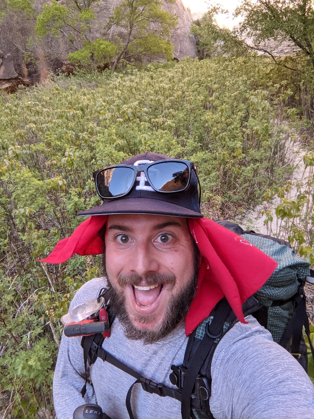
No bugs of note in my experience. Poison ivy was very healthy though. See below.
df54d079a0a651fb6e89c248b3d5ade0.jpg
 
Was in LDH 3 weeks ago doing the BMT. Plenty of water. Can't imagine it being dry. Escalante had water where you cross it heading to the trailhead in Escalante.

No bugs of note in my experience. Poison ivy was very healthy though. See below.
df54d079a0a651fb6e89c248b3d5ade0.jpg
Is that whole area poison ivy??? I can see that the plants in the foreground (just behind you) are - are the rest???
 
Thanks everyone; sounds like we'll go for it. I'm looking forward to finding out exactly how allergic to poison ivy we are...
 
Thanks everyone; sounds like we'll go for it. I'm looking forward to finding out exactly how allergic to poison ivy we are...
Pants and long sleeves(and caution) worked for me and I am quite allergic.

Sent from my Pixel 4a using Tapatalk
 
Is that whole area poison ivy??? I can see that the plants in the foreground (just behind you) are - are the rest???
Yes. Much of the canyon is like that. Between 3-4 ft tall.

Sent from my Pixel 4a using Tapatalk
 
Just finished a hike there this morning. Water in Sand Ck, Death Hollow and in the Escalante R (looking pretty scummy) for a little distance above the DH confluence then dry for a ways and then flowing again. Bugs very mild. Poison ivy extensive in DH.
 
Just finished a hike there this morning. Water in Sand Ck, Death Hollow and in the Escalante R (looking pretty scummy) for a little distance above the DH confluence then dry for a ways and then flowing again. Bugs very mild. Poison ivy extensive in DH.
lol ...... Poision Ivy is always extensive in DH, especially upper DH.... even with no leaves you can get a rash. Best bet ...walk in the water ! :mad:
 
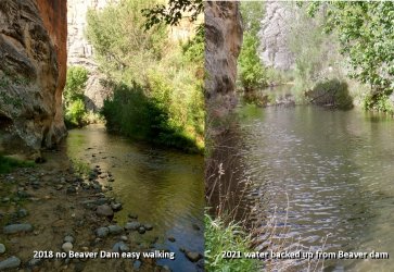
Just tried to hike in the sneak route from the bottom of Death Hollow. It drops you into the Escalante just downstream from the confuence of Death Hollow and the Escalante. Usually ankle deep water in the Escalante just down stream of the confluence of Death Hollow and the Escalante, but now there is a Beaver dam on the Escalante making for very deep water to get past. So if you are going down Death Hollow and intend to then go down the Escalante to the bridge there is that obstacle now.
 
If you head downstream on the Escalante from the Death Hollow Confluence toward the bridge here is what you will encounter. Just downstream. This is looking back up the Escalante toward Death Hollow. I often day hike into the bottom of Death hollow from a sneaker route. Beavers got busy. Downed trees everywhere. Water backed up. Escalante compare.jpg
 
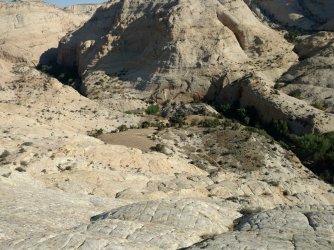
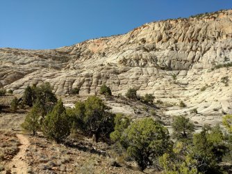
What the sneak route looks like going down to the Escalante. Second one is what the sneak route looks like going up from the Escalante. Makes it so you can day hike into the bottom part of Death Hollow and get out the same day. In the first one you can see where Death Hollow is coming in from the north.IMG_20180630_084344716 - Copy.jpg
 
Last edited:
If you head downstream on the Escalante from the Death Hollow Confluence toward the bridge here is what you will encounter. Just downstream. This is looking back up the Escalante toward Death Hollow. I often day hike into the bottom of Death hollow from a sneaker route. Beavers got busy. Downed trees everywhere. Water backed up.
Thanks for the update! Did you have to swim across these sections? (I can't tell exactly how deep the water is in the photo). Or could you go around the side (on land) easily enough?
 
Thanks for the update! Did you have to swim across these sections? (I can't tell exactly how deep the water is in the photo). Or could you go around the side (on land) easily enough?
We had to go through the water. We just had day packs so we could lift them above our heads and wade.
 
If you head downstream on the Escalante from the Death Hollow Confluence toward the bridge here is what you will encounter. Just downstream. This is looking back up the Escalante toward Death Hollow. I often day hike into the bottom of Death hollow from a sneaker route. Beavers got busy. Downed trees everywhere. Water backed up. View attachment 98765

My wife and a friend of hers also have plans to head down this way this next week and I just told her about this and now she's a little nervous (she's 5'2"). Just how deep was this newfound beaver pool? Would it be no more than a chest high wade? Also wondering what the competition will be like for campsites around the junction over the weekend. One would think that with all the heat, more folks will be heading up into the hills this time of year now that they're all melting out fast, but then again...this area is a nice oasis in the desert so I imagine the Escalante is still quite a popular backpacking destination, even in summer months. I did Death Hollow and Escalante at the tail end of August last summer and remember it not being too bad, but still lots more people than I had anticipated for that time of year.
 
One more question: I'm thinking we may make camp one night near the confluence of Death Hollow and the Escalante and day hike (without the heavy packs) part way up the river towards the town of Escalante and back to our base camp. How nice is that stretch of trail/river? Is there mostly consistent water along that stretch? We will either do this as a side day hike (on Day 3), or alternatively go up the W. side of the Boulder Mail Trail (on Day 2) to the Mamie Natural Bridge and thereabouts. Is one of these day-hikes much better than the other?

Also, my impression is that there should be clear water and at least okay camping in the Sand Creek area just a couple of miles from the trailhead. Is that correct? We'll plan on making it all the way to Death Hollow on Day 1, but if we're delayed, it will be nice to have Sand Creek as a backup plan. It will also be nice to top off on water there.

Thanks again everyone for all the input!
 
Similar threads
Thread starter Title Forum Replies Date
Gretchen Millward Trachyte Creek conditions/water Trip Planning 0
garyhost Cedar Mesa Utah Trip. Conditions? Water? Trip Planning 8
Titans Cedar Mesa 3/11/24- Springs & Road conditions Trip Planning 3
fossana 2024 CO Plateau conditions General Discussion 1
Dreamer Wyoming Range conditions 2023 Trip Planning 62
fossana CO Plateau nuisance flora/fauna conditions 2023 Trip Planning 13
BeardoMcGrath Oh look yet another Utah conditions thread: mid May 2023 Trip Planning 9
F Upper Escalante River Backpack conditions Trip Planning 6
Upgrayedd Uintas Conditions 2023 Trip Planning 39
B Good trips in Southern Utah given current conditions Trip Planning 26
regehr conditions at the Mexican Mountain road? Trip Planning 8
SteveR Tuolumne Meadows Winter Conditions Winter Sports 2
Ross Any Lake Powell experts who can advice on changed conditions at dramatically new lake levels? Trip Planning 3
fossana 2023 drought conditions General Discussion 14
2eez4life Uintas Conditions 2022 Trip Planning 18
OldBill Snow Conditions - Greater Yellowstone Trip Planning 1
fossana 2022 drought conditions General Discussion 71
forest dweller The best / ideal conditions/ criteria to backpack with a stranger / allow a stranger to backpack with you... General Discussion 6
Artemus Wind River Mountains Conditions 2021 Trip Planning 17
C Dinwoody/Bonney Pass Summer Conditions Trip Planning 1
Upgrayedd Uintas Conditions 2021 Trip Planning 9
R Mt. Timpanogas trail conditions Trip Planning 3
IlVagabondo Encampment River Wilderness: Conditions? Trip Planning 0
norwegianxplorer Ski Dogs, Norway, fun days off piste ski touring amazing conditions Winter Sports 0
ergelo Trail conditions in Arc Dome Wilderness (NV) Trip Planning 2
Chuck the Mauler Current conditions at.... Trip Planning 3
Upgrayedd Uintas Conditions 2020 Trip Planning 69
Titans 2020 Road Conditions Southern Utah (& Arizona Strip ) Trip Planning 1
regehr late 2019 road conditions in S Utah Trip Planning 55
powderglut NW Colorado Snow conditions General Discussion 16
powderglut Colonnade Arch road conditions General Discussion 7
Nick Cedar Gnat Conditions General Discussion 19
Janice Maroon Bells Conditions 2019 General Discussion 12
R Escalante River / Calf Creek Falls Current Conditions Trip Planning 10
Artemus Wind River Mountain Conditions 2019 Trip Planning 62
J Uintas Conditions 2019 Trip Planning 209
mike_offerman Deseret and Nebo conditions Trip Planning 3
Brian Dickson Buckskin Gulch conditions? Trip Planning 7
wesleyS The Maze road conditions Off Road 0
P Tuckup Canyon Trailhead road conditions Trip Planning 0
Perry Hiker Dies in the Wave of Appearent Heat-related Conditions General Discussion 12
Upgrayedd Sawtooths conditions Trip Planning 3
regehr Pfeifferhorn conditions? Trip Planning 8
Artemus Wind River Mountains Conditions 2018 Trip Planning 45
M Escalante- Little Death Hollow Loop conditions? Trip Planning 14
Dave Uintas Conditions 2018 General Discussion 210
b.stark Winds snow conditions? Trip Planning 13
regehr Deseret Peak conditions Trip Planning 2
Dave Uintas Conditions 2017 General Discussion 128
Glasterpiece Death Valley Road Conditions Resource Discussions 0

Similar threads

Back
Top