CitD in 2014 or 2015

Bolts! Nice! :)

On the road - are you saying that last bit of Hole-in-the-Rock road to near Clear Creek doesn't requre HC 4WD? Or do you park before the road drops off the bench into the head of Davis Gulch? The first 50 miles is okay for cars in ideal conditions, but that last 7 miles from the top of Davis is solid 4WD territory. Ot at least it is for the other 99.9%. ;)
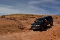
IMG_9355 - Version 2.jpg
 
Lol ......... could be my 'rough' definition is different. The year we did Willow Gulch and Davis there was a buick at the signs by interpretive signs at HIR. remember this was 9 years ago when I was in there. Not to far a walk from where you're saying is a park spot.
 
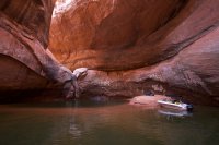
Can anyone provide insight on what the canyon is like as you approach the Cathedral in the water when it's around this level? Is it too narrow for a big boat? Kayaks required? Or could I just motor right in there right now?

We were able to get a good sized motor boat up there when I took that photo. Like it was said, the res is about the same elevation now as it was then.
 
I have been watching the water levels too dreaming about this. @ashergrey where is your chart from? I have been watching here: http://lakepowell.water-data.com/

Would love to be involved if something gets put together. I'll wait and watch intently. Hoping for a decent spring runoff, but if not, oh well...
 
My chart is from the Bureau of Reclamation.
 
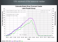
Hmmm... apparently the latest storms have been very good to the upper Green and Colorado drainages. The recent storms left 13% of the seasonal median and the snowpack feeding Lake Powell is now at 109% of the 20 year average. Check this out:

upload_2014-2-13_17-54-1.png

From this video from the NWS about snowpack:

I pick up my boat tomorrow. Starting to think I might have to take a trip down right away to see it while it's as low as it is, just in case it doesn't stay low...
 
High level in the snowpack doesn't perfectly correlate to lake level though, as releases from the Colorado River system reservoirs are governed by interstate compacts and other laws. The BOR already set release rates for the 2014 water year and it would take extreme conditions to change those (look at the inflow and outflow data for Lake Powell and you'll see the outflow is remarkably constant).

That being said, I'm starting to think the weather pattern has changed enough to make the likelihood of seeing the cathedral this year or next pretty unlikely.
 
Once the BOR said it wouldnt release additional water into Meade I knew this wouldnt be the year. Lets hope for extreme dry conditions next year? ;)
 
Once the BOR said it wouldnt release additional water into Meade I knew this wouldnt be the year. Lets hope for extreme dry conditions next year? ;)

Yeah, this year was always a longshot and the graph that I first posted shows it was never projected to be the year. But the result of this year's drought in the lower Colorado River basin states will largely inform what BOR does with releases. If Mead continues to drop and California's drought doesn't ease, abundance in the upper basin states won't matter much.
 
Well that's about a month earlier than normal. I was going to head to the Cathedral in mid-April but it sounds like there might not be much to see.
 
Mmmmm.... that shot with the big sandy beach has me drooling to go on a boat trip. Looks like I might head down and see what's there in mid-to-late April. I imagine the water will have already come up a bit by then though.
 
Probably not by much... I'd expect most of the rise to happen in May.
 
Banner year for the Green and Colorado headwaters... upper Green is at 146% of normal right now, Yampa/White at 124% and upper Colorado 134%.

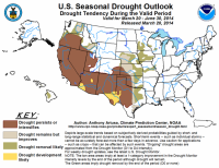
On the flip side, everywhere outside the Green/Colorado and Wasatch Front is forecast to see increasing drought in the next few months.

BjLfNKnIQAAmDN6.png
 
Wild. I hear they are expecting Powell to peak around 3619 now, maybe higher. That would be nearly 45' up from where it is now. Thanks for posting.
 
If you're still planning on running down in April Nick, consider the following from the Bureau of Reclamation:

Unregulated inflow into Flaming Gorge Reservoir during the month of February was 46,000 acre-feet (AF), or 104 percent of average. The reservoir elevation is 6017 feet. Observed inflows are averaging 900 cubic feet per second (cfs).
Flaming Gorge releases are currently 800 cfs steady minimum releases and are anticipated to remain at this level through winter until spring runoff beings sometime in April or May.
Forecasts remain above average and Flaming Gorge Dam is in the moderately wet hydrologic classification for the spring flow period as outlined in the February 2006 Record of Decision - Operation of Flaming Gorge Dam Final Environmental Impact Statement. Inflows for the next three months are projected to be above average: with March, April and May forecasted inflow volumes at 115,000 AF (112% of average), 160,000 AF (120% of average), and 350,000 AF (143% of average), respectively. The March final forecast of the April-July unregulated inflow volume into Flaming Gorge Reservoir is 1,430,000 AF (146% of average). Based on the March final forecast, the spring hydrologic classification will be moderately wet.

So in other words, BOR will crank up Flaming Gorge releases from their mandatory minimums in either April or May. The timing will largely depend on when the Winds and eastern Uintas start melting out, I'd assume. The reservoir inflows in May could lead to some pretty awesome boating conditions on the Green (curses I didn't pull a deso permit during the spring) but will also mean a healthy influx to Powell.

Based on the current forecast, the March 24-Month study projects Lake Powell elevation will peak near approximately 3,619 feet near the end of June and end the water year near 3,615 feet with approximately 13.28 maf in storage (56% capacity). Note that projections of elevation and storage have uncertainty at this point in the season, primarily due to uncertainty regarding the season’s total snowpack and the resulting inflow to Lake Powell.

I read that as saying now is probably your best chance to see at least part of the cathedral this year and likely next year.
 
Yeah, I think it is too. Next year won't be this low. I'm going to head down there with my wife around the middle of April, assuming the weather is pretty close to ideal. She's a fair-weather camper so I actually had to sell her on going in April! Fingers crossed....
 
Finally made it in to the Cathedral on Tuesday of this week. The lake level was at 3574' so still about 19' higher than 2005's all time low. The place was a lot cooler than I was expecting but it is quite hard to capture in a photo. There is actually a sandbar in there right now big enough that you can beach and get out of the boat, but sadly, it was taken by another group so we just drifted around for a while. Surprising since we had only seen about two boats on the entire lake at this point in the trip. Full trip report coming later.

IMG_0666.jpg

IMG_0670.jpg
 
Back
Top