Canyonlands in winter/off-season

OwenM

Member
Joined
Aug 6, 2019
Messages
345
What's the earliest/latest you'd go for ~5 nights in the Needles district(plus a day or so for some dayhikes at Arches if there's time)? As far as dates, I'm up for for anything between late January and early March.
I'd like as much solitude as possible without having to wear microspikes the whole time...
Not sure if road conditions should be a big concern or not(?). I really just need to get to and from Squaw Flats.
Thinking Peekaboo Trail to Salt Creek, in/out down to Wedding Ring Arch, plus Angel Arch, and back to Lost Canyon Trail.
Then Lost Canyon to Squaw Canyon to Chesler Park after Druid Arch.
Maybe circle back around and come back to Squaw Flat via Big Springs Canyon Trail.
Think that's about 70ish, total.
I suppose the big question is water. Does Salt Creek actually have flow? What about around Chesler Park? Do I need to be carrying my usual 1.4L, or is it going to be more like 4.1?
Temps aren't a huge deal, but trail conditions could be.
Don't I need a bear canister, too?
Thanks!

Edit: After studying the map more closely, I can make this work if the springs marked on the NatGeo map are flowing(my assumption is that they will be in winter), but it means hauling quite a bit of water between them. Any other reliable sources?
 
Last edited:
@OwenM - we just hiked about 84miles in the Needles, but it was all day hikes from Squaw Flat or Elephant Hill. I can’t answer all the questions, especially about the springs and water sources, but here is a few comments :

- I don’t know if anyone can predict how early you can go, it all depends on the weather this winter. Even Micro spikes wouldn’t help on the many (!) slickrock sections of the Needles, if there’s ice.

- if there’s been any recent Ice/snow storm, then the road conditions are worst on the paved section between rt191 and Indian Creek, because it’s much higher elevation and it melts slower up there. We drove it just after a storm last year, it wasn’t plowed at that point. It was a bit tense, but we made it down to Squaw Flat.

- all backpackers we have met in the Needles look completely wiped out (or tell us, they are really exhausted), most tend to underestimate how difficult the mileage is there and they often carry a ton of water.

- We have never seen water at Chesler Park. Some other areas, but I’m hesitant to write where in public, I can PM you. Perhaps the backcountry office can help out via the phone when you get closer?

- Peekaboo trail to Salt Creek: it’s a lot of slickrock hiking and between Lost canyon and Salt creek there’s a lot of shaded slickrock areas, where we have seen an almost invisible layer of ice on the slickrock, even in early December. There’s a few very exposed slickrock sections on that trail and if there is any ice on those sections, then you will not be able to get out to Salt Creek from Squaw Flat via the Peekaboo trail IMO.

- the connector trail between Druid Arch and Big Spring canyon has some Moki steps, and a super narrow cave/passage, again, any ice and you cannot pass. See photos I posted in the “trail photo album“. The connector trail between Chesler Park and Squaw Flat would probably be ok.

- Druid Arch in the winter. @Scott Chandler “lived to tell the tale“ so to speak, exciting RT, one of my favorites. https://backcountrypost.com/threads/druid-arch-in-winter.5436/


@John Morrow - did you see this, do you have any input?
 
Thank you so much. A preponderance of ice would change everything, and that's what I'd like to avoid.
I really just want to beat the crowds, so might should have said "off-season" instead of "winter" in the title.
Since I can go any time, whatever window there is with good trail conditions and minimal people is good for me.

It generally clears out after Thanksgiving, when it dips towards 20F at night. :)
 
What's the earliest/latest you'd go for ~5 nights in the Needles district(plus a day or so for some dayhikes at Arches if there's time)? As far as dates, I'm up for for anything between late January and early March.
I'd like as much solitude as possible without having to wear microspikes the whole time...

I typically go on our first backpacking trip of the season to the Needles in early to mid March. We've had some nice temperatures at this time of the year, but last year it was pretty cold during our visit. While you can probably go later in February, the weather then is more unpredictable and would work better as a last-minute trip based on current conditions.
 
Headed that way week after next. Man, those temps on the 10 day forecast look glorious. Lows ~20 and highs ~40 is my idea of perfect hiking weather!
I'd appreciate some suggestions for basecamping and dayhiking, too.
After a pretty terrifying guided tour of a MRI by an orthopedic surgeon and a spinal last week, I'm carrying on, but it isn't business as usual. Probably gonna be cutting down on the miles, and taking it easy, so will most likely just leave off Salt Creek altogether.
 
Great @OwenM - enjoy your trip! The MRI event doesn't sound so good....

Check you private messages- I wrote a list for you, decided to take it off-line.
 
FYI, March 9th is the first night you can reserve a backcountry campsite in The Needles.
 
FYI, March 9th is the first night you can reserve a backcountry campsite in The Needles.

Yah, I just noticed that too on the on-line permit website.
Is it self-registration "first come first serve" before that time, do you know? We met some backpackers early December, they were not really sure, where they were going to camp. But it wasn't busy back then.
 
Yah, I just noticed that too on the on-line permit website.
Is it self-registration "first come first serve" before that time, do you know? We met some backpackers early December, they were not really sure, where they were going to camp. But it wasn't busy back then.
I honestly don't know if camping overnight before the 9th is allowed. Call the Canyonlands office and ask them.
 
I’ve backpacked quite a bit in the winter there and unless it’s changed, you just pick up a self service permit

Was just there in January. Yes, self service and allowed. Some years not much of a ranger presence, but this year talked to a couple different rangers both at Squaw Flat and then again at Elephant Hill trailhead. she even asked if we had a wag bag, since I had brought my own, and not taken one from the self serve when we had taken our permits.
 
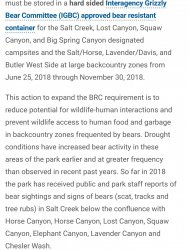
The info I initially saw only specified Salt Creek as requiring bear canisters, but I found this the other day, so Salt Creek or no, I'm taking a BV450. 86671

Are the wag bags supplied by the park as...nice(usable) as the Cleanwaste ones you can buy at REI?
I've only dayhiked in places that required them, and haven't needed one-which is a good thing, since I've never gotten one to begin with!
 
The above bear can order was temporary, in response to drought conditions, and was allowed to expire at the end of the specified period in 2018. No can needed unless in salt creek.

Reiterate what others have said about shady slickrock. Peekaboo tr can be dangerous this time of year.

I like salt creek for a winter trip. No exposures you're in the canyon bottom. Yes there is water.
 
Ha! Figures. I actually ordered the bear can for that reason.
That's ok, Salt Creek may be back on the menu, anyway. I've been feeling great this past week, and may even go back to plan A.
There are some other places that have started requiring bear cans in the East, plus some out West where it'll keep me from having to rent one, so no complaints.

Gosh. I just reread my own post, and it's right there "through November 30, 2018".
Makes me wonder, am I just getting old, the painkillers screwing up my attention span, what? Lot of good it's ever done me, but I had college level reading comprehension in grammar school. So much for that!
 
Last edited:
Thanks again, everyone, especially Titans!
My back has given me no problems, and I'm in Moab after tearing up the Needles for 3.5 days. Looking to check out Island in the Sky and Arches for a day each, now.
The Joint trail and Chessler Park were great(gone through CP twice, camped at CP5 last night).

Yesterday morning, I hiked ~5 miles from camp in Elephant Canyon back up to my rental car at Squaw Flat, because I underestimated the amount of water I needed.
Left Squaw Flat with 5 liters, went down Big Spring Canyon to the bottom part of Squaw Canyon over to the bottom half of Elephant Canyon, back over to Chessler Park, and camped at CP5.
This morning was out Chessler Park, down to Druid Arch, back up Elephant Canyon and around to Squaw Flat by lunchtime.
I don't have enough superlatives to describe that hike. Has to be the most epic overnighter I've ever done. Absolutely incredible.
Yesterday had to be the longest 12.5 miles in history, though. Either that, or my math is way off!
I was so fired up that none of it struck me as difficult, but it just seemed like it would never end. That route barely even crosses contour lines on the map(how is that possible?!?), and I had no idea what I was getting into.

Couldn't help but imagine how terrifying the lower part of yesterday's route would be to someone not accustomed to hiking on slickrock!

Awesome, glad you enjoyed it....and yah, there’s regular miles and then there’s “Needles miles”.....
We love it there, enjoy the rest of your trip. Have fun!
 
Thanks again, everyone, especially Titans!
My back has given me no problems, and I'm in Moab after tearing up the Needles for 3.5 days. Looking to check out Island in the Sky and Arches for a day each, now.
The Joint trail and Chessler Park were great(gone through CP twice, camped at CP5 last night).

Yesterday morning, I hiked ~5 miles from camp in Elephant Canyon back up to my rental car at Squaw Flat, because I underestimated the amount of water I needed.
Left Squaw Flat with 5 liters, went down Big Spring Canyon to the bottom part of Squaw Canyon over to the bottom half of Elephant Canyon, back over to Chessler Park, and camped at CP5.
This morning was out Chessler Park, down to Druid Arch, back up Elephant Canyon and around to Squaw Flat by lunchtime.
I don't have enough superlatives to describe that hike. Has to be the most epic overnighter I've ever done. Absolutely incredible.
Yesterday had to be the longest 12.5 miles in history, though. Either that, or my math is way off!
I was so fired up that none of it struck me as difficult, but it just seemed like it would never end. That route barely even crosses contour lines on the map(how is that possible?!?), and I had no idea what I was getting into.

Couldn't help but imagine how terrifying the lower part of yesterday's route would be to someone not accustomed to hiking on slickrock!
You summarized the exact feelings I've had every time I've backpacked in the needles!
 
A lot of this stuff should be common knowledge for members here, but if anyone unfamiliar with the area and conditions should read this thread while searching for Needles info(particularly fellow Easterners!), I'll throw in some data points and observations.

Weather can change from one week, much less year, to the next, but here are a few takeaways from my trip:
-It was cold. Temps were lower at night than those forecast for Canyonlands Needle District(which will give you Moab if you aren't more specific), or even nearby Monticelo. It was mid-teens my first couple of nights, in spite of not finding a single forecast predicting temps lower than 24F. This is consistent with all 7 of my trips to UT, whether high desert or mountains, in either very early spring or very late fall, where temps have always hit the teens at some point.

-It was warm. Daytime temps did not break 50F, though my thermometer showed as high as 70+ in direct sunlight, and I thought several times that "it feels like it's 80F out here".
Major temperature swings between day and night, commensurate with what I've experienced above 12k' in the Rockies in late fall.
After waking up to 15F, I'd soon be hiking with a very light and breathable "sun hoody" as my only layer up top.

-At the time of my visit, there was ice along some trails, but practically none anywhere you would actually step. I carried Kahtoola Microspikes, but did not have occasion to use them.

-Water was an issue. There were exactly zero reliable water sources during the course of my trip, which covered most of the hiking trails west of, and including, Big Spring Canyon.
No available water at all, aside from puddles in creek beds where the sun hit some leftover ice during the day.
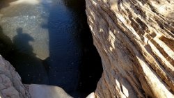
There were two good sized pools with lots of water(one off-trail back in a canyon, the other right by a trail, too close to Squaw Flat to be much use, anyway), but they were frozen.
Very frozen...
87104

-There is a LOT more up and down than looking at the NatGeo topo would suggest. Lots of short, steep climbs and descents, often punctuated by relatively flat hiking between.

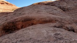
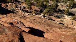
-Some spots are extremely steep. I do not think it's an exaggeration to say there's a 60-70 degree incline in several places.
These are only navigable due to the grippy nature of slickrock when it's dry. If I were guiding some of my friends who are unaccustomed to hiking on this type of terrain and surface, I would definitely start the trip with a milder dayhike like the Slickrock Trail, and take that opportunity to do some confidence-building exercises(I even made some videos to that effect, for the benefit of a friend I may take there in late fall).
Steeper than they look, as these are videocaptures with the camera angled in the direction I'm going, but these are indeed the "trail", and you can walk right up or down them:
87105
See the cairn?
87106

-Between the Joint Trail's slots, a crack that must be passed through on whatever that's called below where Big Spring and Squaw Canyons meet, and several very narrow climbs and descents, these hikes are not mesh water bottle pocket friendly. New holes in the mesh on both sides of my Osprey Exos 38. I will likely be taking a heavier, but much more durable, pack my next time through here, or at least taping up those corners ahead of time.

-This area is also not tent stake friendly. A freestanding tent, or extra lengths of cord for my tarp's guyouts to facilitate using rocks as anchors, would have been welcome. Weather allowing, I will cowboy camp with my groundsheet and/or bivy in the future, and only set up the tarp if rain is threatening.

-The sun. Moderate daytime temps or not, this is still the desert. Totally exposed, and very bright, unless it's cloudy. I was rarely without one hood or another, never without a cap, sunglasses, and long sleeves.
 
Similar threads
Thread starter Title Forum Replies Date
TrailScot Canyonlands NP Needles backpacking permit in winter General Discussion 5
rinats Canyonlands/Needles: Salt Creek to Chesler Park Trip Planning 6
M Canyonlands, and some random routes Trip Planning 7
SeanIsADesertRat Interesting/mysterious patterns Needles District, Canyonlands General Discussion 19
Desertratgal Backpacking/Packrafting Needles and Maze Districts of Canyonlands Trip Planning 3
Desertratgal Packrafting Canyonlands Round 2: Dates? Trip Planning 2
Desertratgal 5 Days Solo Packrafting Canyonlands On The Water 4
Desertratgal Canyonlands Packrafting Rough Draft Trip Planning 18
dpnoll Colorado Canyonlands Backpacking 10
angeedraper Canyonlands - Needles 2 Night Backpacking (April 29-May1) Backpacking 0
J Canyonlands Needles District simple backpack with a close friend April 1-3, 2021 Backpacking 2
IntrepidXJ Arches and Canyonlands National Parks Accepting Comments on Proposed Fee Increases for Backcountry Operations General Discussion 38
Laura V. Bears in Salt Creek Canyon, Canyonlands Trip Planning 76
IntrepidXJ Canyonlands Permits going to Recreation.gov General Discussion 4
J Family hike in the Maze in June? (Canyonlands / Moab) Am I crazy? Trip Planning 5
Parma Pssst, don't tell anyone but Canyonlands is opening up General Discussion 3
gnwatts BLM Oil and Gas lease auction, Arches, Canyonlands, Bears Ears etc. General Discussion 5
DouginGJCO Hiking &/or backpacking partner for Canyonlands Natl Park and nearby Noobs: Introduce yourself! 0
chandlerwest Monument Basin - Canyonlands NP - Not enough hours in a day. Hiking & Camping 6
JBPHXAZ Canyonlands Needles Backpacking Suggestions Trip Planning 8
P Salt creek in Canyonlands Trip Planning 13
Parma Missing Person In Canyonlands General Discussion 2
U Maze District of Canyonlands question Trip Planning 15
M Water in Canyonlands Salt Creek early April? Trip Planning 11
zionsky Arches & Canyonlands closed due to snow General Discussion 12
Benjamin Hayden Looking for advice on Maze District, Canyonlands Trip Planning 1
C cave of 200 hands in Canyonlands Trip Planning 0
AKay09 Canyonlands NP: Needles District 4/24-4/27 Backpacking 11
IntrepidXJ Canyonlands National Park: Expanded Bear Container Requirements General Discussion 7
K Hiking the Needles Canyonlands Trip Planning 9
J Canyonlands Natl Park Needles District Circumnavigation April 9 to 15, 2018 Backpacking 1
D Canyonlands 1976 Backpacking 2
Brian Skibbe Moab, Arches NP, Canyonlands NP. May 2017 Hiking & Camping 3
JDWalters Canyonlands/ Needles District question Trip Planning 5
J "Mazing" Six day backpack in Canyonlands Maze Dist. Pt 2. April 13-15, 2017 Backpacking 8
J "Mazing" Six day backpack in Canyonlands Maze Dist. Pt 1. April 10-12, 2017 Backpacking 0
blueeyes Canyonlands/Moab Jug Handle Bikepack Loop March 18, 2017 Everything Else 21
C Canyonlands: Chesler Park, Virginia Park ??? Trip Planning 7
Mike Schasch Canyonlands/Needles hiking along river Trip Planning 7
George_Washington_Hayduke Canyonlands Figure 8: Packrafting Loop through the Needles and Maze District Backpacking 3
C Horse Canyon on Canyonlands Trip Planning 7
D 2 or 3 DayTrip To Canyonlands National Park Trip Planning 34
C day hikes in Canyonlands Needles in late November Trip Planning 19
Vegan.Hiker Canyonlands NP (Part 4 of 4) Backpacking 14
Vegan.Hiker Canyonlands NP (Part 3 of 4) On The Water 8
J Canyonlands Needles Dist.: Crosscanyon Backpack Traverse April 10-15, 2016 Backpacking 1
Vegan.Hiker Canyonlands NP (Part 2 of 4) Backpacking 18
Vegan.Hiker Canyonlands NP (Part 1 of 4) Backpacking 12
DrNed Canyonlands - Island In The Sky Hiking & Camping 12
DrNed Camping Outside of Canyonlands Trip Planning 7

Similar threads

Back
Top