- Joined
- Dec 11, 2015
- Messages
- 2,066
I and 4 friends from the lesser 48 had booked 1-way flights to Anaktuvuk Pass in the Brooks Range so we could backpack from there to the Haul Road (that serves the oil fields on Alaska's north coast). After spending part of the morning, and an hour or so in the afternoon at the terminal, it was announced that our flight was cancelled due to poor weather and the next flight was on Monday. As this was Friday, I scrambled to come up with a new plan. I opted for a revision of a packraft trip I had planned for next summer. This trip was the packraft trip in reverse with no boats involved. As I had already left my vehicle at the endpoint of the original trip, we booked seats on a shuttle service to the Brooks Range. The shuttle driver let me off so I could move my vehicle a few miles north to our new endpoint, then allowed me back on to ride to our trip's starting point.
I usually try to keep photos to a relative minimum but it's hard to stop uploading Brooks Range porn. Hopefully you enjoy BR porn as much as I do.
Eventually we were at our starting point.


We took off within minutes of being dropped off. Clouds and rain would dominate the weather, but that's the Brooks Range in the fall.

Within a half-hour, I spotted a grizzly and her 2 cubs along the creek. We were able to watch her and the cubs for 20 minutes or so without being detected. We moved up to a point above her and eventually saw a 3rd cub.


After more gazing, we eventually moved along toward camp 1, passing some recent grizzly diggings along the way.


The next morning, we took off through a narrow drainage with limestone- and shale-covered slopes. Not too long into this, a band of Dall sheep ewes and lambs crossed the bottom and headed away from us.


We reached the base of the pass we planned to use and after ascending that, we dropped into the next drainage and ascended another slope before taking a much-needed break. The relentless scenery made it all worthwhile.


One more elevation drop, a small climb, and we would be traveling on flatter ground for a few hours. Unfortunately the flat ground was mostly marshy tussocks that slowed our progress greatly. We found some antlers along the way.


I read long ago that traveling through the tussocks is like walking on hairy bowling balls. It still seems to be the best description. Ankle-sprainers, knee-twisters, trip-enders. We slogged through these trying to enjoy the scenery without losing too much focus on step placement. We passed a few grizzly scats, took several breaks and eventually reached the 1,200-foot drop to the valley floor that we would be traveling through for a few days.


A downstream view.

Scenery from camp 2. The clouds were in constant flux.


The next morning we started our way upriver. The day consisted of avoiding the marshes as best as possible and multiple stream crossings. And the never-ending scenery. We also had brief periods of sunshine.


Drying off and putting the boots back on.

We continued upriver enjoying the scenery, clouds, and blue sky.


Taking in some sun.

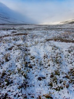
Snowline has dropped the previous 2 nights. We were able to hike considerable distances on the dry channels of the braided river which is the easiest traveling of all here. We made camp on sandy deposits on the gravel bars.


The sun and clouds provided us a great evening to relax.


The next morning greeted us with sun. After a quick channel crossing, the travelling continued to improve. Surprisingly, there were quite a few flowers still in bloom.


Another grizzly makes an appearance. It is impossible to tell anything from this picture but it looks like a youngish male.

About 20 minutes after taking the picture of this member of the group, we watched a sow grizzly and her 3 cubs along the base of the low ridge behind his head. They had likely scented us and were trying to figure out where we were. She eventually led her cubs about 1,600 vertical feet up the ridge along the right edge of the photo.


A monster pile of berry-filled griz scat. The berry production in this valley was huge. Blueberries, crowberries, cranberries, and bear berries in great abundance.


We had just been watching another lone griz across the river when we hit a fork of the river that is running higher than expected. We plan to cross it a few miles upstream where it is braided. More antlers disappearing into the tundra and a cow moose. The fall colors have really been coming in as the trip progresses. We spooked a huge bull moose out of the tall willows earlier today but I failed to take a picture.


Another stream crossing, heading up a new valley, and more fall colors.


We had made good progress today and a couple of us were ready for a break so we stopped at a good campsite. A big chunk of limestone, camp, and a previous bear scat along a caribou trail.


That evening, the winds picked up as did the rain. I was used to falling asleep with the rain hitting my tent but was awakened when the winds pushed the side of my tent into my face. We discovered that one of the group was having trouble with water coming into his tent and eventually pooling on the floor. We thought we had that sorted out so I fell back asleep pretty quickly. The morning greeted us with a new surprise and an exhausted group member who had been awake all night.

As soon as the sun broke out, the snow started melting rapidly. We quickly warmed up the exhausted and cold member and hit the (caribou) trail.

With good reason, the exhausted member was not enthused about continuing up the drainage. We convinced him to give it a try, which he did for about 45 minutes. He finally admitted he was done. As in DONE. Completely exhausted. We discussed a few options, considered the upcoming terrain, but his legs and his body and his spirit were done so after some discussion and his agreement, I hit the rescue button on the InReach. About 4 hours later the MedEvac helicopter (a Sikorsky 92 for those interested) came in and took him and another group member (his good friend and neighbor) to Deadhorse, the development that supports the oil fields. As we awaited the eggbeater, the weather turned gorgeous and warmed considerably.
Down valley.

After their departure, the 3 of us continued up the valley.


It was best that he had quit when he did as the delay that morning leaving camp would require 2-3 long days to reach our original destination. The additional delay in waiting for the helicopter caused us to shorten the remainder of the trip a bit, so rather than continue up the long valley, we cut up a side valley that should have us out the next evening. We fought through some tall willows for a good while at the bottom of the side valley, then faced a relatively long and steep climb up a side valley to our next camp. After that it was a climb up a high pass and then either another high pass or a long walk down valley to the road.
As I lagged well behind this group member, I realized I had barely eaten all day. We eventually took a break to have dinner, then continued to camp.


More great scenery from camp.

The pass in the back is what we will climb in the morning.

The morning opened with low clouds. We left camp heading up valley and hoping the clouds lifted, which they did not. Regular topos were nearly useless as the scale was 1:25,000 but still lacked sufficient detail for route finding. We were able to track our progress using topos downloaded on Avenza. After an arduous climb we reached the pass and started down. The slope up to the pass was comprised of broken limestone and small pieces of shale. Luckily a few sheep trails allowed us better progress. The rest of the day was relatively easy.


Almost there.

The descent, although steep, was pretty easy. The ground was soft with shale scree and the knees held up. The scenery opened up as we descended which provided more great views.


We continued down valley to the main creek, decided not to hike the pass looming ahead of us, passed an arctic poppy, then followed the main creek out the rest of the day.


Eight more miles of scenery.
Upstream


Easy walking.


Twenty minutes to catch a ride back to the vehicle. Forty minutes back to pick up mi amigos, then a long drive back to Fairbanks in the rain.
I usually try to keep photos to a relative minimum but it's hard to stop uploading Brooks Range porn. Hopefully you enjoy BR porn as much as I do.
Eventually we were at our starting point.
We took off within minutes of being dropped off. Clouds and rain would dominate the weather, but that's the Brooks Range in the fall.
Within a half-hour, I spotted a grizzly and her 2 cubs along the creek. We were able to watch her and the cubs for 20 minutes or so without being detected. We moved up to a point above her and eventually saw a 3rd cub.
After more gazing, we eventually moved along toward camp 1, passing some recent grizzly diggings along the way.
The next morning, we took off through a narrow drainage with limestone- and shale-covered slopes. Not too long into this, a band of Dall sheep ewes and lambs crossed the bottom and headed away from us.
We reached the base of the pass we planned to use and after ascending that, we dropped into the next drainage and ascended another slope before taking a much-needed break. The relentless scenery made it all worthwhile.
One more elevation drop, a small climb, and we would be traveling on flatter ground for a few hours. Unfortunately the flat ground was mostly marshy tussocks that slowed our progress greatly. We found some antlers along the way.
I read long ago that traveling through the tussocks is like walking on hairy bowling balls. It still seems to be the best description. Ankle-sprainers, knee-twisters, trip-enders. We slogged through these trying to enjoy the scenery without losing too much focus on step placement. We passed a few grizzly scats, took several breaks and eventually reached the 1,200-foot drop to the valley floor that we would be traveling through for a few days.
A downstream view.
Scenery from camp 2. The clouds were in constant flux.
The next morning we started our way upriver. The day consisted of avoiding the marshes as best as possible and multiple stream crossings. And the never-ending scenery. We also had brief periods of sunshine.
Drying off and putting the boots back on.
We continued upriver enjoying the scenery, clouds, and blue sky.
Taking in some sun.
Snowline has dropped the previous 2 nights. We were able to hike considerable distances on the dry channels of the braided river which is the easiest traveling of all here. We made camp on sandy deposits on the gravel bars.
The sun and clouds provided us a great evening to relax.
The next morning greeted us with sun. After a quick channel crossing, the travelling continued to improve. Surprisingly, there were quite a few flowers still in bloom.
Another grizzly makes an appearance. It is impossible to tell anything from this picture but it looks like a youngish male.
About 20 minutes after taking the picture of this member of the group, we watched a sow grizzly and her 3 cubs along the base of the low ridge behind his head. They had likely scented us and were trying to figure out where we were. She eventually led her cubs about 1,600 vertical feet up the ridge along the right edge of the photo.
A monster pile of berry-filled griz scat. The berry production in this valley was huge. Blueberries, crowberries, cranberries, and bear berries in great abundance.
We had just been watching another lone griz across the river when we hit a fork of the river that is running higher than expected. We plan to cross it a few miles upstream where it is braided. More antlers disappearing into the tundra and a cow moose. The fall colors have really been coming in as the trip progresses. We spooked a huge bull moose out of the tall willows earlier today but I failed to take a picture.
Another stream crossing, heading up a new valley, and more fall colors.
We had made good progress today and a couple of us were ready for a break so we stopped at a good campsite. A big chunk of limestone, camp, and a previous bear scat along a caribou trail.
That evening, the winds picked up as did the rain. I was used to falling asleep with the rain hitting my tent but was awakened when the winds pushed the side of my tent into my face. We discovered that one of the group was having trouble with water coming into his tent and eventually pooling on the floor. We thought we had that sorted out so I fell back asleep pretty quickly. The morning greeted us with a new surprise and an exhausted group member who had been awake all night.
As soon as the sun broke out, the snow started melting rapidly. We quickly warmed up the exhausted and cold member and hit the (caribou) trail.
With good reason, the exhausted member was not enthused about continuing up the drainage. We convinced him to give it a try, which he did for about 45 minutes. He finally admitted he was done. As in DONE. Completely exhausted. We discussed a few options, considered the upcoming terrain, but his legs and his body and his spirit were done so after some discussion and his agreement, I hit the rescue button on the InReach. About 4 hours later the MedEvac helicopter (a Sikorsky 92 for those interested) came in and took him and another group member (his good friend and neighbor) to Deadhorse, the development that supports the oil fields. As we awaited the eggbeater, the weather turned gorgeous and warmed considerably.
Down valley.
After their departure, the 3 of us continued up the valley.
It was best that he had quit when he did as the delay that morning leaving camp would require 2-3 long days to reach our original destination. The additional delay in waiting for the helicopter caused us to shorten the remainder of the trip a bit, so rather than continue up the long valley, we cut up a side valley that should have us out the next evening. We fought through some tall willows for a good while at the bottom of the side valley, then faced a relatively long and steep climb up a side valley to our next camp. After that it was a climb up a high pass and then either another high pass or a long walk down valley to the road.
As I lagged well behind this group member, I realized I had barely eaten all day. We eventually took a break to have dinner, then continued to camp.
More great scenery from camp.
The pass in the back is what we will climb in the morning.
The morning opened with low clouds. We left camp heading up valley and hoping the clouds lifted, which they did not. Regular topos were nearly useless as the scale was 1:25,000 but still lacked sufficient detail for route finding. We were able to track our progress using topos downloaded on Avenza. After an arduous climb we reached the pass and started down. The slope up to the pass was comprised of broken limestone and small pieces of shale. Luckily a few sheep trails allowed us better progress. The rest of the day was relatively easy.
Almost there.
The descent, although steep, was pretty easy. The ground was soft with shale scree and the knees held up. The scenery opened up as we descended which provided more great views.
We continued down valley to the main creek, decided not to hike the pass looming ahead of us, passed an arctic poppy, then followed the main creek out the rest of the day.
Eight more miles of scenery.
Upstream
Easy walking.
Twenty minutes to catch a ride back to the vehicle. Forty minutes back to pick up mi amigos, then a long drive back to Fairbanks in the rain.
Attachments
Last edited:
