Brooks Lake area to Younts Peak via the Continental Divide

Some more photos from this area for everyone...
...Wild and Nice Younts Peak
Just a few photos from the area ... Enjoy! Good Wild Country as it is meant to be. Wishing Everyone the Best!

Not only are the images spectacular, but fascinating to see Younts and other areas at different times of the season/year and with various amounts of snow cover. A thoroughly enjoyable experience and feast for the eyes.
 
In the upper stretches of the South Fork of the Buffalo, there are several drainages that come down into the South Fork from the Buffalo Plateau ... all of these drainages have old routes or trails up them made by the outfitters from long ago. Have been on some of them. One of these goes up a drainage, first one down from the pass of the South Fork with Cub Creek ... this goes up the drainage then also goes on down the other side - Crescent Creek to the head of the South Fork of the Shoshone. There is also a very nice pond - small lake offtrail right south down the slopes off of Crescent Mountain that have looked down upon a number of times.

Wow. How did I miss seeing this thread before?!?

For a while now, I have been in awe of @Kmatjhwy 's narrative description of this region, not to mention her photos at her other site. (and I have been amazed at the locations of those photos, realizing how incredibly far any of those are from any established trail / route. She has really covered an immense amount of real estate!


@Kmatjhwy , I would love to spend an afternoon (or three!) just listening to you talk about the route knowledge you have in your head. You are an amazing resource, and I thank you for all you have contributed here.

In that quote above that I excerpted, you mention unofficial outfitter trails down most of those drainages of the S.Fk Buffalo.... Which is interesting, because a while back I was messing around with CalTopo, seeing if I could come up with [non-official] travel routes off the divide that I could talk my wife into backpacking with me, without [hopefully!] ruining my marriage. ;-) (My wife is NOT fond of scree, bush-whacking, and off-trail route-finding in general.)

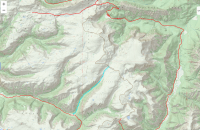
So I was focusing in on the Wall Mountain - Crescent Mountain section of the divide..... [see maps below]

I thought that one particular drainage on the south / west of the continental divide, starting at the saddle where Marston Creek's headwaters start and flow in the opposite direction, might be a feasible route down to S.Fk. Buffalo. It's the one I have marked below in blue dots (the red lines are 'official' forest service trails.) Might that canyon / drainage be one of those you alluded to above, with outfitter paths in it? [reference note: South Fork Shoshone trail is on the far right; Marston Pass / Ferry Lake is along the top edge. Bottom right trail is the Crescent Creek trail, coming up to the divide from S.Fk. Shoshone.....]Absaroka Crescent-Buffalo1.png

The sattelite photos of the area suggest the west/north side of that creek might have the best terrain to pick a route through. But that was before I read this thread where you suggested that there might already be an outfitters path down through here.

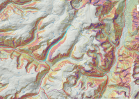
Here's another map shot of the same area, with the slope angle shading I used to help me pick this drainage. Despite the steepness of the canyon walls, it suggests a fairly graded route all the way down to the trail at S.Fk. Buffalo....
Absaroka Crescent-Buffalo.png
 
Wow. How did I miss seeing this thread before?!?

For a while now, I have been in awe of @Kmatjhwy 's narrative description of this region, not to mention her photos at her other site. (and I have been amazed at the locations of those photos, realizing how incredibly far any of those are from any established trail / route. She has really covered an immense amount of real estate!


@Kmatjhwy , I would love to spend an afternoon (or three!) just listening to you talk about the route knowledge you have in your head. You are an amazing resource, and I thank you for all you have contributed here.

In that quote above that I excerpted, you mention unofficial outfitter trails down most of those drainages of the S.Fk Buffalo.... Which is interesting, because a while back I was messing around with CalTopo, seeing if I could come up with [non-official] travel routes off the divide that I could talk my wife into backpacking with me, without [hopefully!] ruining my marriage. ;-) (My wife is NOT fond of scree, bush-whacking, and off-trail route-finding in general.)

So I was focusing in on the Wall Mountain - Crescent Mountain section of the divide..... [see maps below]

I thought that one particular drainage on the south / west of the continental divide, starting at the saddle where Marston Creek's headwaters start and flow in the opposite direction, might be a feasible route down to S.Fk. Buffalo. It's the one I have marked below in blue dots (the red lines are 'official' forest service trails.) Might that canyon / drainage be one of those you alluded to above, with outfitter paths in it? [reference note: South Fork Shoshone trail is on the far right; Marston Pass / Ferry Lake is along the top edge. Bottom right trail is the Crescent Creek trail, coming up to the divide from S.Fk. Shoshone.....]View attachment 76573

The sattelite photos of the area suggest the west/north side of that creek might have the best terrain to pick a route through. But that was before I read this thread where you suggested that there might already be an outfitters path down through here.

Here's another map shot of the same area, with the slope angle shading I used to help me pick this drainage. Despite the steepness of the canyon walls, it suggests a fairly graded route all the way down to the trail at S.Fk. Buffalo....
View attachment 76574
I had very similar questions about the next canyon to the west called "Turner Fork" two years ago. Didn't end up attempting it while I was out there, but aerial imagery seems to show trails in places through Turner Fork and the one you asked about. For the drainage you mention, it sure looks like a trail at 43.8727091, -109.8748211. It's hard to tell otherwise though. I'd bet there may be a bit of bushwhacking, but there's also probably some semblance of a trail for a lot of it. The South Buffalo Fork has trails on both sides for most of the way. When my friend and I passed the drainage you mentioned, we were on the south side of the creek, unfortunately, so I didn't get a visual on any forks in the trail on the north side. I'm going to go back through my photos to double check for any evidence though.
 
Now for some information, I personally have not been up or down this one side drainage with the blue dots marked on the map. But the drainage that I have been up and down is the next one to the east or right up the drainage that is coming down that has the fork of two drainages in its upper reaches. One year I came off of the north of the two forks, camped down near where they came together, then leisurely strolled on down on a good trail to the upper South Fork of the Buffalo. I have also been in the upper reaches of the other fork on my journeys when up and down across the Buffalo Plateau along the Divide. But it is nice all thru out in here. But the north fork of this side drainage which I strolled down is nice and has NO Scree! It was a leisurely hike down off of the Buffalo Plateau and C. Divide thru grassy meadows with an old route. Then near where the two forks came together, I ran into a good route / trail which ran all the way down to the Upper South Fork of the Buffalo. It came out to the South Buffalo Fork just a short ways up from where this side creek entered the South Fork.
It is all amazing country in here. One could camp here and there, hike here and there, spend every summers here and there in these Absarokas and one still would not see it all. Now hope this helps. It is now April and this white stuff is melting. The next summer is coming and hope everyone is ready!

Langdon, Thanks for the compliment! Wishing Everyone the Best!
 
Similar threads
Thread starter Title Forum Replies Date
wsp_scott Yellowstone Lake to Brooks Lake (Aug 2023) Backpacking 16
Bob The Thorofare to Brooks Lake - 9 Days in Pictures Backpacking 10
TeamJenkins17 Yellowstone Thorofare to Brooks lake trip next year. Trip Planning 6
Georgia Yankee Teton Wilderness: Ariz. Creek to Brooks Lake, July 2016 Backpacking 26
Joey Teton Wilderness, Absaroka's, Brooks Lake, Cub Creek Backpack Loop Backpacking 12
Outdoor_Fool Brooks Range trek - Anaktuvuk Pass to the Haul Road - Cancelled Flight - last minute change-up Backpacking 21
scatman Grebe Lake - September 4th through the 6th, 2024 Meet Up (Members Only) 20
K How long in Lake Bled? Trip Planning 1
Mikjik86 Backpacking Indian Peaks Wilderness - King Lake - August, 2023 Backpacking 0
Ugly Two Popular Lake Basins in the Cascades Backpacking 12
TheMountainRabbit Ortenburger Lake, Talus Lake, & Glacier Peak (Grand Teton NP) - October 2023 Backpacking 14
kwc Fall hike to Chase Lake, Southern Adirondacks Hiking & Camping 1
TrektheWorld Red Deer Lake & Beyond Backpacking 10
shredhiker Thorofare, Heart Lake, Snake River Sept. 2023 Backpacking 16
Bob Wind Rivers - Short Trip to Cook Lake Trip Reports 9
regehr (Uintas) Lake Fork Fun Backpacking 8
Timber High Sierra - North Lake to South Lake Loop - Layover Day Trip Planning 9
kwc Limekiln Lake paddle On The Water 0
shredhiker YNP Fawn Pass to Sportsman, Crescent, Shelf Lake Backpacking 11
Janice Lizard Head Plateau - overlook Upper Cathedral Lake? Trip Planning 15
uintafly Chepeta Lake to Hayden Pass Trip Planning 0
DrNed Naturalist Basin: Blue Lake to Shaler Lake? Trip Planning 12
shredhiker YNP Fawn Pass to Sportsman & Crescent Lake Trip Planning 14
kwc Jockeybush Lake- southern Adirondacks Hiking & Camping 0
shredhiker Yellowstone Heart Lake September 2022 Backpacking 9
TheMountainRabbit Black Lake (Rocky Mountain NP) - January 2023 Hiking & Camping 3
Ross Any Lake Powell experts who can advice on changed conditions at dramatically new lake levels? Trip Planning 3
NorthwestWanderer Backpacking Grand Teton National Park : Fossil Pass,Fox Creek Pass,Indian Lake,Alaska Basin,Hurricane Pass,Ice Floe Lake,& Snowdrift Lake Backpacking 19
NorthwestWanderer 8 Day High Sierra trek : Humphreys Basin, Star Col, Granite Park, Lake Italy & Piute Canyon 6/25-7/2/22 Backpacking 7
TractorDoc Yellowstone's Wrangler Lake, Bog Creek, Joseph's Coat Springs, Broad Creek, Wapiti Lake, Hot Springs Basin, and Pelican Valley. The Second Half. Backpacking 15
kwc Another Southern Adirondacks hike - Clockmill Pond and Rock Lake Hiking & Camping 0
TractorDoc Yellowstone's Wrangler Lake, Bog Creek, Joseph's Coat Springs, Broad Creek, Wapiti Lake, Hot Springs Basin, and Pelican Valley. Part One of Two. Backpacking 61
kwc Round Lake, north central Adirondacks, in the Round Lake Wilderness On The Water 2
Jackson Heart Lake and Snake River for Labor Day Backpacking 23
scatman Pacific Creek, Moss Lake and Gravel Lake - Teton Wilderness - October 7, 2022 Backpacking 32
TractorDoc Yellowstone's Hayden Valley, Trout Creek, Beach Lake, and Arnica Creek Meadows. September 11, 2022. Hiking & Camping 7
balzaccom Obata Lake...xc in Yosemite Backpacking 0
scatman Grizzly Lake - September 7, 2022 Backpacking 31
P Yellowstone, one night by a lake Backpacking 19
kwc A Few More Photos from Scatman’s Grizzly Lake trip … Backpacking 3
P Scatman's Grizzly Lake hike, 2022 Backpacking 28
P Yellowstone--Heart Lake to South Entrance Backpacking 13
scatman Shoshone Lake Lollipop Loop - Yellowstone National Park - July 24, 2022 Backpacking 63
T How big are the Mirror Lake campgrounds in the Porkies? Trip Planning 6
Georgia Yankee Apostle Islands, Lake Superior (again), June 2022 On The Water 4
kwc Adirondack Hike to Middle Lake Hiking & Camping 0
K Hello from the Salt Lake Valley Noobs: Introduce yourself! 2
J Lake Powell at 3528 feet General Discussion 1
WasatchWill WRHR: Day 5 - Camp Lake to Titcomb Basin Backpacking 15
WasatchWill WRHR: Day 4 - Halls Lake to Camp Lake Backpacking 17

Similar threads

Back
Top