Since I didn't make it into the Absaroka/Thorofare area last year I am going to try next summer. I was curious if it is possible to follow the Continental Divide from the Brooks Lake area all the way to Younts Peak. Looks like most of it would be doable but there are a couple sections I'm not so sure about.
Navigation
Install the app
How to install the app on iOS
Follow along with the video below to see how to install our site as a web app on your home screen.
Note: This feature may not be available in some browsers.
More options
You are using an out of date browser. It may not display this or other websites correctly.
You should upgrade or use an alternative browser.
You should upgrade or use an alternative browser.
Brooks Lake area to Younts Peak via the Continental Divide
- Thread starter JeffG
- Start date
b.stark
Forever Wandering
- Joined
- Apr 8, 2015
- Messages
- 1,192
I've mapped out a couple routes that follow the Divide for a good chunk of the way from Brooks Lk to Thorofare Mountain. Would really like to get up to that area someday, maybe make it a super long one and swing over to the Thorofare/Hawk's Nest area.
My routes don't seem to cover anything that seems sketchy, but I'm not committed to strictly following the divide the whole way, either. Nor have I actually backpacked in the area, so take my word with a big bowl of salt.
My routes don't seem to cover anything that seems sketchy, but I'm not committed to strictly following the divide the whole way, either. Nor have I actually backpacked in the area, so take my word with a big bowl of salt.
JeffG, Now I saw your message, but have had no time yet to respond. Have been working all day, Tomorrow will be able to give you a really good reply on your question in depth. But I had to say something now to start. I Personally do not have my own computer, so am at the local library usually where able to respond.
Now in short, the Continental Divide for most of the way actually from the North End of the Wind Rivers up into Montana is easily walkable. There is a few difficult spots. Here near Brooks Lake are the Breccia Cliffs and such. But one can go around them to get up on top and then proceed north. Or one can go from Brooks Lake over to lovely Cub Creek, then up this drainage to the head pass. From here the Continental Divide at Crescent Mountain is not far away, here it would be easy easy walking north towards Younts Peak. Most of the way is across the vast and rolling alpine tundra expanse of the Buffalo Plateau. This is easy wild country trekking with incredible views in all directions. Have done this trek following the Continental Divide across the gorgeous Buffalo Plateau a number of times and one would not regret this trek. Also in going across the Buffalo Plateau, it would be a must stop to climb nearby Wall Mountain on the way. And as for the area around Younts Peak, you could spend the entire summer in and around this area and never once have a bad day. Also grizzlies are quite abundant near Younts Peak. I have had a number of super close encounters with them in here, so be on the lookout.
Near Younts Peak the Continental Divide takes a jog west then north again. have hiked this part of the divide also. Fabulous and no problems. Lots of nice wild nooks and crannies in here with grizzlies always nearby. From Ferry Lake and north, then Continental Divide turns north. Love Love Love this section of the Divide. Really Super Wild! Fabulous Views in all directions. This is from Ferry Lake to Jay Peak to near Two Ocean Pass. The Divide in here is also mainly easy trekking and Incredible. Then across the Two Ocean Plateau up into Yellowstone is wild and terrific also. Just some added info.
Now will be posting more tomorrow when I have the time and everything. Just a bit for now.
- Joined
- Jan 4, 2015
- Messages
- 2,885
It all goes and is incredibly scenic, pleasant walking. Crescent Mountain itself is annoyingly talusy; stay on the bench west of the actual peak if you want to make things easier for yourself. The view up top is pretty good but only you can decide if it's worth the talus or not.
I can send you additional details via PM.
I can send you additional details via PM.
Now am back here again! Now do think will write a more lengthy report of this are for you. Do think that most of the Continental Divide from the very Northern Wind River Range to Southern Montana is walkable. In some place might be some cliffs and such where one would have to go around. Have been along and nearby most of the route of it here in NW Wyoming.
Now for this area you are inquiring about, from Brooks Lake to near Younts Peak. This is mainly walkable and have done this on several occasions. First near Brooks Lake are several cliffed mountains which to go north on the Continental Divide, one would have to go around. There are several ways from Brooks Lake itself. One would be going east from Brooks Lake with up Bonneville Creek to nearby Bonneville Pass. Then here one can walk up the slopes nearby to the top and the Continental Divide here. Then one can proceed north / northeast along the Divide here. One would go up along the Divide to a pass near Boday Lake and Perry / Boday Creek near Crescent Mountain. Also one could proceed north from Brooks Lake to nearby Bear Cub Pass and on down to Cub Creek on the other side, then on up Cub Creek to it's head at a pass with the headwaters of the South Fork of the Buffalo River on the other side. Have camped here in this area a number of times and it is a nice place. Nearby is the Perry / Boday Creek Drainage. Here one can go over to near Boday Lake and the Continental Divide. Then it is just a walkup to the top of Crescent Mountain. As Larryboy said, Yes in here the Crescent Mountain area are areas of talus and boulder fields. But Crescent Mountain has a terrific view here of looking over the Northern Wind River Valley with the Northern Wind River Range in the distance. Also which I have done, one can go east from here to nearby Shoshone Pass and the headwaters of the South Fork of the Shoshone River. Now from Crescent Mountain to Marston Pass it is an easy up and down alpine tundra experience going across the immense Buffalo Plateau. I have heard that several people might have problems route finding across this plateau. But I have traversed it a number of times and never have had any problems. The views in all directions is incredible. There are certain drainages and low points here and there one has to cross on going north along the Buffalo Plateau. There are certain drainages that start on the Buffalo Plateau and flow down to some river drainage nearby. Most of these drainages have routes and old trails in them made from the hunting outfitters of days gone by. Some of these sub drainages has some nice nocks and crannies in their head basins. Some small alpine lakes are also scattered here and there on the Buffalo Plateau. Along the way across the Buffalo Plateau is Wall Mountain which affords a terrific view especially down into the wild environs of the South Fork of the Shoshone River below. When I have climbed Wall Mountain before, always would see some scat of some Bighorn Sheep around the area. At Marston Pass there is a good trail over to the South Fork of the Yellowstone and the Younts Peak area. The head basin of the South Fork of the Yellowstone is immense and gorgeous with Younts Peak nearby. There are some good camping places a shortways down the South Fork of the Yellowstone which have camped at in the past. Also one can go over to the 11,000 foot pass between Younts Peak and Thorofare Mountain and go on down to the upper basin of the North Fork of the Yellowstone. Both of these upper basins at the head of the North and South Forks of the Yellowstone can provide many days of delightful camping. Also Younts Peak is a Moth Site area and Grizzlies are common in the area. I have had several close encounters with Grizzlies in here. Also onetime I saw near 12 Grizzlies here in oneday up on the slopes of Younts Peak feeding on the moths. If one climbs Younts Peak, it can be a walk up with exceptional views in all directions with looking over miles and miles and more miles of good unroaded wild country. There is so much country here in the Greater Younts Peaks and the headwaters of the Yellowstone River area, that one could spend days, weeks, months, or multiple summers seeing and exploring it all like I have done and still not see it all. From the head of the Yellowstone, there is a good trail down the South Fork of the Yellowstone, and good routes down the North Fork of the Yellowstone or over to the head of the Thorofare River nearby. Also will remark here that going over to Thorofare Mountain and north along the Absaroka Mountain Divide, which is off the Continental Divide would be an awesome wild offtrail trek also.
Now will continue on describing the Continental Divide from here near Marston Pass and the Younts Peak area to Yellowstone Park for those that are interested. There is alot of good wild country in here and have walked and wandered thru here repeatedly. From Marston Pass the Continental Divide swings west for a bit to the Ferry Lake area. Here it goes along on a grassy rolling alpine ridge with good views. One way is looking over to Younts Peak and the South Fork of the Yellowstone below. The other way is looking out over the Buffalo Plateau to the south. Easy trekking along this ridge. On the way is a back basin here which is just gorgeous. It is located away from the trails and in a back basin way above the infant Yellowstone River below. One could camp in this back basin for days and weeks with not seeing another soul. Then from near Ferry Lake the Continental Divide swings over to nearby Jay Peak near the head of the North Fork of the Buffalo River to near Yellowstone Point near the head of Jay Creek. There is a fabulous alpine basin at the head of the North Fork of the Buffalo which have camped in many a time. Good places for Grizzlies also for have had a number of close encounters with them there. Here this entire way the Divide is on grassy alpine ridges with excellent and fabulous views in all directions. Plus in here it is all offtrail good wild country. In here when trekking the C. Divide in here I would have Eagles soaring overhead, herds of hundreds of Elk nearby, some Grizzlies here and there, and more. Good Wild Country and have done it a number of times. Then right off the Divide is this Yellowstone Point area. In here one has excellent views down into the Thorofare - Yellowstone Meadows below. Good place for Grizzlies also. Here if one wants which I have done is a good bushwhack down Jay Creek to it's lovely gorgeous meadows, then on a trail here down lower Jay Creek to Atlantic Creek near Two Ocean Pass. Or on a route down around Senecio Creek to nearby Atlantic Creek. At the head of Jay Creek, the C. Divide swings west and north to Two Ocean Pass which can also being easily traversable to near Atlantic Peak, then down by whatever means one can to Two Ocean Pass below. At Two Ocean Pass there is a good trail up and over on Two Ocean Plateau to nearby Phelps Pass at the Mink Creek / Falcon Creek area. And up on top there is lots of areas for exploring. Also one can continue wandering around now on the Two Ocean Plateau north into Yellowstone and now all offtrail. The area in the very SE part of Yellowstone Park on top of the Two Ocean Plateau with here named Lynx on the map is some good wild country. Have been here a time or two with always seeing Bears in the area and more huge Elk herds. Good Wild Country. Then the C. Divide continues north wandering thru lower wooded terrain in Yellowstone Park till the Centennial Mountains on the Idaho / Montana border.
But all along this whole Continental Divide area from near Brooks Lake to Yellowstone Park and country nearby is how much good super wild country where people could spend days, weeks, months, or even multiple summers exploring. So many good wild nocks and crannies in here away from everything with still being like it has always been - wild and nice.
Also on my photo website at www.reflectionsofthewild.zenfolio.com is posted photos of this country for those that are interested.
Hope this helps whoever might be interested. Wishing Everyone the Best!
Last edited:
- Joined
- Jan 4, 2015
- Messages
- 2,885
I think an absolutely fantastic loop would be to take the Divide off-trail to the Marston Pass area, follow the trail on the S side of Marston Pass west to Ferry Lake, then take the Divide off-trail again to the head of Jay Creek. Head down Jay Creek to Two Oceans Pass area and hit up Parting of the Waters (a really, really, really cool spot). Then back to your car at Brooks Lake via the CDT.
Dang I really want to do that loop now. Looks terrific.
Dang I really want to do that loop now. Looks terrific.
I think an absolutely fantastic loop would be to take the Divide off-trail to the Marston Pass area, follow the trail on the S side of Marston Pass west to Ferry Lake, then take the Divide off-trail again to the head of Jay Creek. Head down Jay Creek to Two Oceans Pass area and hit up Parting of the Waters (a really, really, really cool spot). Then back to your car at Brooks Lake via the CDT.
Dang I really want to do that loop now. Looks terrific.
After reading the latest info from Kmatjhwy I've had similar ideas for a route. The mileage would be pretty high. I'm going to map out some route options over the next week to get a better idea on mileage.
Now think you would both love it in there. Good Wild Country! You could spend days and days and days in there. Now that portain of the C. Divide from Ferry Lake to Jay Peak and then on up to the head of Jay Creek is just fabulous! I think of it often with especially in the winter. Now thinking of being myself back in there somewhere again next summer.
Onetime going along the C. Divide in here, on a rock was an oldtime instamatic camera just sitting there. I picked up and took a look at it, then set it back right where it was. It is still up there today and rusting away. So many places back in there, one will not see another person especially when away from the trails. The meadows up in Jay Creek are just super super gorgeous. There is a trail - route up to them that goes off of the Atlantic Creek Trail. A good trail also. On my photo website I do have some photos posted of the Jay Creek Meadows. And in those photos, the cliffs in the background is the Continental Divide.
Now am more than happy to help any of you who are interested in this country further any time you want. Now all of this country is how it should be all wild and nice ... The Real World! Now thinking of this good wild country and typing all of this gets my heart racing again with my memories and everything.
Wishing Everyone The Best!
sagebrush
New Member
- Joined
- Dec 2, 2018
- Messages
- 3
...Also on my photo website at www.reflectionsofthewild.zenfolio.com is posted photos of this country for those that are interested...
Checked it out. Glad I did! Many thanks for sharing.
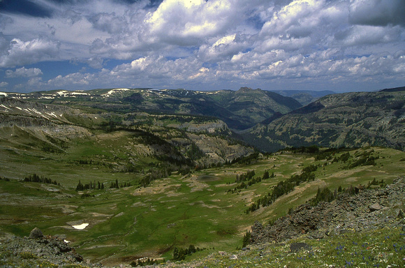
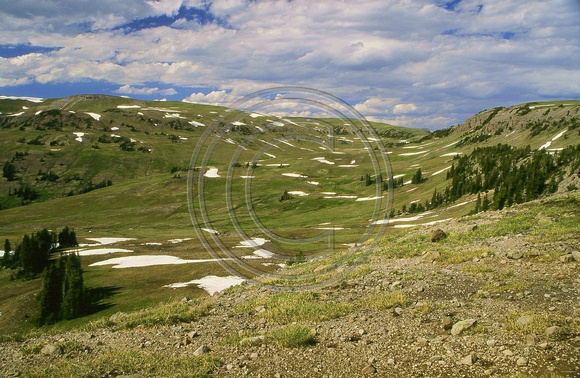
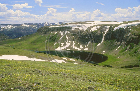
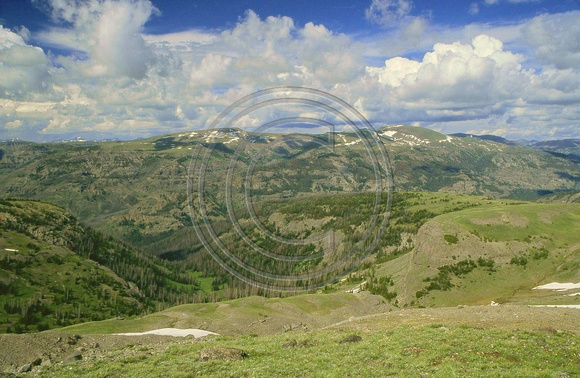
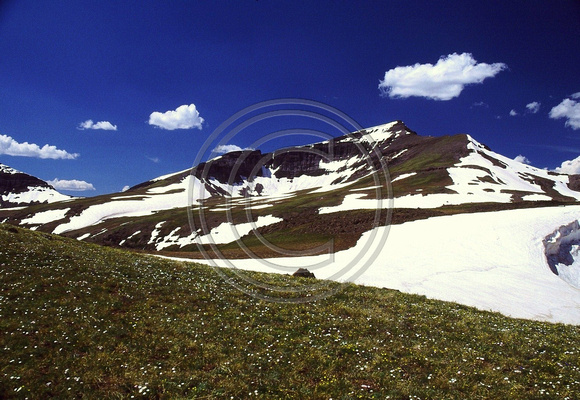
Now here are some photos I have from my website from this greater area for everyone since we have been talking of this are. And also like they say, a photo is worth a thousand words or such. Enjoy.
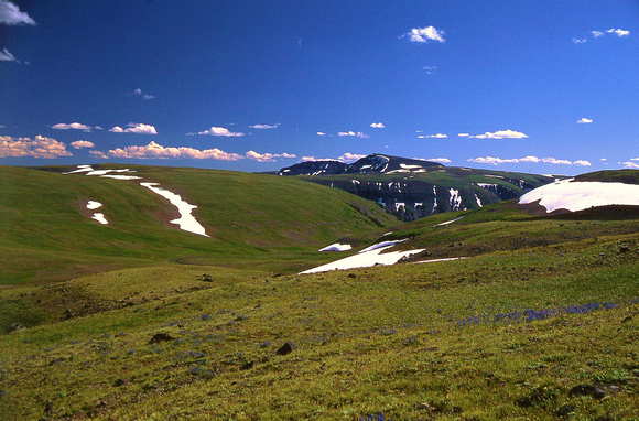
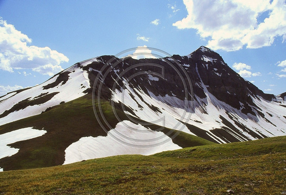
Looking along the C. Divide from near Jay Peak with Younts Peak in the distance. Late morning and late in the day photos.
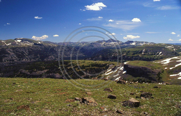
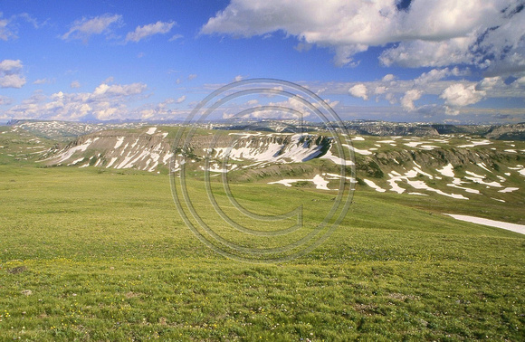
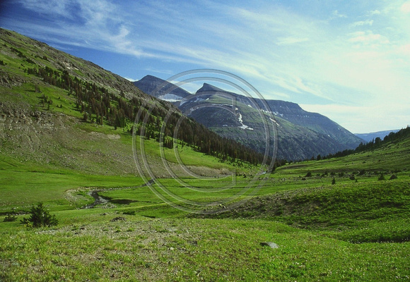
Looking across the Buffalo Plateau with the Tetons in the distance.
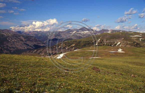
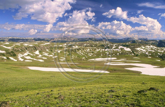
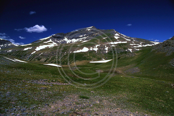
Somewhere on the Buffalo Plateau with Crescent Mountain in the distance.
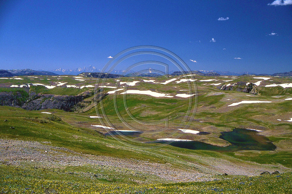
A nice back basin away from the nearby trails all wild and nice near the C. Divide., with looking down the Yellowstone River drainage.
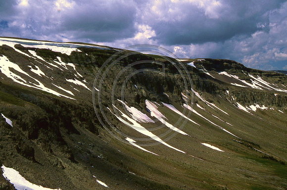
Cliffs on a mountain along the C. Divide above this certain back isolated basin.
Beautiful Jay Creek Meadows with the C. Divide behind the meadows, not far from Atlantic Creek and Two Ocean Pass.

Looking along the C. Divide from near Jay Peak with Younts Peak in the distance. Late morning and late in the day photos.
Looking across the Buffalo Plateau with the Tetons in the distance.
Somewhere on the Buffalo Plateau with Crescent Mountain in the distance.
A nice back basin away from the nearby trails all wild and nice near the C. Divide., with looking down the Yellowstone River drainage.
Cliffs on a mountain along the C. Divide above this certain back isolated basin.
Beautiful Jay Creek Meadows with the C. Divide behind the meadows, not far from Atlantic Creek and Two Ocean Pass.
Last edited:
Some more photos from this area for everyone.
Here near Jay Peak looking to the SE and over the nearby Buffalo Plateau environs. 1 of 2 and 2 of 2
Head basin of the North Fork of the Buffalo with the rolling C. Divide and Jay Peak behind the basin. Over the ridge is Woodard Canyon.
Some of my most closest Grizzly Bear encounters have been in this basin.
Along the C. Divide looking down on Tri County Lake in these parts.
Along the C. Divide in here looking over towards Thunder Mountain on the otherside of the Yellowstone River.
Wild and Nice Younts Peak
Somewhere wild near Younts Peak in a out of the way place where I had another super close Grizzly Bear encounter.
Just a few photos from the area ... Enjoy! Good Wild Country as it is meant to be. Wishing Everyone the Best!
Kmatjhwy, beautiful pictures! I have a couple more questions for you after looking over maps. Are there any sketchy sections along the CD above Jay Creek down to Two Ocean Pass? This section looks like it could have some steep/exposed stuff but hard to tell for sure. Also, is it pretty straight forward to drop off the CD into upper Jay Creek and follow that creek to Atlantic Creek? And one more question. When you refer to Jay Peak where is that? I don't find it on the map I am looking at but I assume it is somewhere by the headwaters of Jay Creek. Thanks again!
Now JeffG, glad that you enjoyed the photos.
Now as for Jay Peak, it is only marked Jay on the maps and it is at an elevation of 10,931 feet with being right on the C. Divide. It is located southeast of Tri County Lake and Jay Creek. Also it is north of Crater Lake which is at the head of the Soda Fork Drainage. Jay Peak is what I call it. And it is located near the very headwaters of the North Fork of the Buffalo River.
Now as for going down Jay Creek, it is an easy drop off of the C. Divide into the head basin of Jay Creek. Then it is a lovely good bushwhack down Jay Creek. Jay Creek is a lovely stream with it always having small cascades all the way down in near the meadows. Last time I went down Jay Creek, there was quite a bit of dead and down timber because of the pinebark beetles. And then the cliffs are right there on either side. Right when you drop off, there might be a little steepness but still grassy and poses no problems whatsoever. The head basin is small and nice! Could camp in here away from everything. The meadows in Jay Creek are fabulous!!! And in the lower end of them is a good trail or route down to Atlantic Creek which comes out a few miles below Two Ocean Pass. I love the Jay Creek Meadows and have been there numerous times!!!
Now as for the C. Divide of where it swings west from north of Tri County Lake to Two Ocean Pass. This ridge narrows up with cliffs and really steep sides on either side of this ridge, but the top of the ridge is traversible. There is a small lake along here on top of the ridge called Benchmark Lake. One can get to Atlantic Peak. Check the maps but there will be a ridge in here where you should be able to get off down to near Two Ocean Pass. Not many people at all walk this ridge. Also near the lake might be a little steep terrain, if too steep, one can bushwhack down to Trail Creek below for no cliffs in there. In the forests below could be quite a bit of down timber - old fires and bug kill.
Hope this answers your questions. Personally I love those Jay Creek Meadows. I personally love high mountain meadows. Never seen a Grizzly in Jay Creek but have seen their scat. The library is closing so better get going. Next summer will be most likely back in here somewheres. Wishing You the Best!
- Joined
- May 31, 2015
- Messages
- 3,304
I'm planning to head that way next summer as well, probably August. Tried to get up on the Buffalo Plateau near Younts two summers ago and ended up with too much rough bushwhacking on my route over above the South Buffalo Fork. Really looking forward to getting back out there.Since I didn't make it into the Absaroka/Thorofare area last year I am going to try next summer. I was curious if it is possible to follow the Continental Divide from the Brooks Lake area all the way to Younts Peak. Looks like most of it would be doable but there are a couple sections I'm not so sure about.
- Joined
- Jan 4, 2015
- Messages
- 2,885
New theory: that bear that tried to steal my ursacks wasn't a grizzly after all. It was Jackson.I'm planning to head that way next summer as well, probably August. Tried to get up on the Buffalo Plateau near Younts two summers ago and ended up with too much rough bushwhacking on my route over above the South Buffalo Fork. Really looking forward to getting back out there.
You really ought to brush your teeth better young man!
Jackson, so you also are thinking of getting back into this country next summer. Good for you! It is such good country. Maybe if some of us are back in there, we could meet up somewheres. Do know as for myself, am thinking of being way back in these wilds somewhere wandering about and enjoying life.
Now also a couple of other pointers ....
In the upper stretches of the South Fork of the Buffalo, there are several drainages that come down into the South Fork from the Buffalo Plateau ... all of these drainages have old routes or trails up them made by the outfitters from long ago. Have been on some of them. One of these goes up a drainage, first one down from the pass of the South Fork with Cub Creek ... this goes up the drainage then also goes on down the other side - Crescent Creek to the head of the South Fork of the Shoshone. There is also a very nice pond - small lake offtrail right south down the slopes off of Crescent Mountain that have looked down upon a number of times.
Also if someone is at Ferry Lake and wants to continue north along the Continental Divide ... there are several ways to continue north. One is over the nearby mountain following the C. Divide itself. Second is over to the head of Woodard Canyon, then thru it's head basin to the left or west and over a small pass to the head of the North Fork of the Buffalo which I have done and provides no problems. Another a third way is to go on the trail from Ferry Lake towards Crater Lake and the head of the Soda Fork of the Buffalo. One goes by a very small rise on the way. On a flat with a few trees and right before a big descent down to Crater Lake, here on this flat with just a few trees - one can go right or north towards the North Fork of the Buffalo. There is a small cliffed ridge in here that one will have to go over. Also on this flat where one goes off the trail is some interesting small stone circles of rocks here and there in the area. One goes up to the ridge, then where this small cliffed ridge meets the mountain on the right, there is a small route up and over the ridge to the top. On top is a bunch of room with a good view over to the head basin of the North Fork of the Buffalo. On the other side is a nice sloping bench ramp with super easy walking down into the head basin of the Buffalo. Have been done this a number of times also. For whatever it is worth.
Wishing Everyone the Best!
Don't like ads? Become a BCP Supporting Member and kiss them all goodbye. Click here for more info.