Broads Fork Twin Peaks, Robinson's Variation - September 29, 2018

scatman

Member
.
Joined
Dec 23, 2013
Messages
3,629
Back in July, my daughter and I attempted to summit the Broads Fork Twin Peaks via the Robinson's Variation (Bonkers for @Artemus). A route that I had never attempted before. Unfortunately, it was an extremely hot day and my daughter ran out of gas at the top of the Robinson's Couloir and we had to call it a day. Fortunately for me, @regehr wanted to attempt this route also, so we scheduled the 29th of September for an attempt and hopefully a little cooler weather.

The weather yesterday turned out to be fabulous for us, though the wind was blowing fairly hard along the ridge and on the summit. While we summited via the Robinson's Variation, we descended the normal route.

Here are some shots of our hike and hopefully @regehr will add some shots he took along the way to this report.

03.jpg
Fall colors on the way up Broads Fork

04.jpg
Broads Fork Valley in the morning light

05.jpg
Regehr ready for the couloir

06.jpg
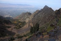
A look up at the ridge we will be scrambling across to the eastern summit of Twin Peaks

08.jpg
The saddle we will climbing to at the top of the Robinson's Couloir

09.jpgFall colors on our way up the draw

13.jpg
Beware of the slabs! :)

15.jpg
Regehr below, Broads Fork Valley and Wildcat Ridge in the distance

17.jpg
Once at the saddle, Broads Fork Twin Peaks comes into full view

18.jpg
Regehr, on the scramble across the ridge

19.jpg
The ridge line of the Robinson's Variation

20.jpg
A look down Deaf Smith Canyon

21.jpg
A view back along the ridge we scrambled across

22.jpg
A view to the east of Sunrise and Dromedary Peaks along the Cottonwood Ridge

23.jpg
View of the western summit of Twin Peaks

24b.jpg
Looking up at the eastern summit of Twin Peaks. It became really steep from this point to the top

25.jpg
On the eastern summit

26.jpg
Starting our descent

28.jpg
A look down on the knife's edge ridge we will make our way across descending the normal route

29.jpg
Broads Fork Valley and Wildcat Ridge, looking north

30.jpg
Aspens showing off on our way down

31.jpg
A lone aspen with a beautiful yellow hue - not to be confused with Hugh. :)


@regehr - add any commentary or images you would like to this report and thanks for a great hike.

The end.
 

Attachments

  • 20.jpg
    20.jpg
    346.7 KB · Views: 43
Last edited:
Wow, impressive! Beautiful shots and it looks like the two of you had an amazing day.
 
Great! I do need to go that way. The colors in Broads look fantastic, and that rock is always beautiful all year long.

Well. Well done.

You should call some of those colors Hugh's Hues...
 
Were most the slabs loose or were they pretty solid in place? Great TR!

The slabs are solid, just steep. Once you have committed to them, you eventually run into a second slab, laying on the first, about belly button high and then a third that is more like a wall. At this point, one realizes that you will have to make your way laterally across the slabs or go back down. These two options are trickier than walking up them due to steepness, small loose rock and dust. My daughter and I made that mistake back in July, so I avoided the slabs this time and just dealt with the steep scree.
 
Great! I do need to go that way. The colors in Broads look fantastic, and that rock is always beautiful all year long.

Well. Well done.

You should call some of those colors Hugh's Hues...


This Hugh's Hues are just pale white I'm afraid.. :)
 
Were most the slabs loose or were they pretty solid in place? Great TR!
The big slabs in upper Bonkers are solid, but very steep, and not as grippy as I'd have liked. I made a mistake venturing into the slab zone instead of staying in the grass and rocks and this not only slowed me down but was also pretty scary in a few places.

(Edit: Whoops I see that I'm just repeating what Scatman said already, I replied without reading!)
 
This was a great hike, thanks @scatman for making it possible!

I had been pretty nervous about the ridge part of this route but the scrambling turned out to be really manageable, there was always a way through that wasn't super difficult or scary.

From afar it looks like there's no hiking route up the base of the summit cone, but there's a nice climbers' path to the right of the cliffs, sort of hidden in the trees.

I'm not in as good shape as I've been other autumns and this route really kicked my butt. 48 hours later I'm mostly back to normal though!
 
Similar threads
Thread starter Title Forum Replies Date
scatman Broads Fork Twin Peaks - July 14, 2020 Hiking & Camping 20
JohnP Twin Peaks via Broads Fork Hiking & Camping 15
lostlandscapes Broads Fork, Wasatch Mountains Hiking & Camping 11
Tyler Broads Fork - Big Cottonwood Canyon June 2011 Hiking & Camping 0
regehr (Uintas) Lake Fork Fun Backpacking 8
RockyMntCol Trip Planning Younts Peak / South Fork Yellowstone Trip Planning 12
J Pacific Creek or North Buffalo Fork? Teton Wilderness, Thorofare ,etc. Trip Planning 10
travel2walk Gros Ventre Wilderness: Granite Creek, West Fork Crystal Creek, Crystal Creek, & Swift Creek - June 2021 Backpacking 8
wsp_scott Big South Fork Bikepacking Backpacking 1
RyanP The Plug exit of Pictograph Fork (Maze) Trip Planning 15
BJett Big South Fork National River & Recreation Area Packraft/Backpack Loop (TN) Backpacking 6
wsp_scott Honey Creek (Big South Fork) Backpacking 9
regehr Wilson Fork, Millcreek, Wasatch Hiking & Camping 1
Perry Henry's Fork Basin - Camp Site Suggestions Trip Planning 3
A Wind Rivers: Clear Lake, Faler Lake and Roaring Fork General Discussion 7
scatman Grandeur and Church Fork Peaks Loop - May 29, 2021 Hiking & Camping 19
RyanP North Fork Bull Lake Creek Trip Planning 35
wsp_scott Big South Fork Views Backpacking 14
scatman Church Fork Peak - November 28, 2020 Hiking & Camping 2
U Favorite sites in Glacier in North Fork, Lake McDonald or Cole/Nyack? Looking at mid july Trip Planning 2
scatman Mount Raymond via Bowman Fork - June 27, 2020 Hiking & Camping 6
K Floating down South Fork of the Snake (ID) Trip Planning 1
Dhuff3243 North Fork Robbers Roost and Blarney canyon Trip Planning 0
P West fork of Salt Creek? Trip Planning 4
F Coyote Gulch via Dry Fork? Trip Planning 2
Ross Anyone want to do East Fork Fat Man's Misery-Barracks-Labyrinth Falls Oct 15 (tues) Trip Planning 0
J How is the dirt road to the East Fork of Blacks Fork TH? Trip Planning 1
DrNed Cell service in American Fork Canyon will be a reality by 2020 General Discussion 13
Perry Middle Fork Blacks Fork Ridge Way Trail - Does It Exist? Hiking & Camping 5
Ross Invite Boundary/Kolob/Narrows & East Fork Fat Man’s/Labyrinth Falls (Oct) Meet Up (Members Only) 4
fossana Grand Gulch Pt 1 - Slickhorn 3rd to Trail Fork loop Hiking & Camping 6
Windy Middle Fork Salmon 2018 On The Water 9
DrNed Red Castle Kings Peak Henry's Fork Take Two Backpacking 8
Born to Hike Windriver 36 mile loop: Skull Lake, Washakie Pass, South Fork Lakes, Lizard Head Trail, The Cirque, Big Sandy Lake Backpacking 6
McKee80 Glacier NP, part 2. North Fork, Sept 2018 Backpacking 11
regehr Mill B North Fork Hiking & Camping 6
Miya Stuart Fork TH Again Backpacking 6
DrNed Upper Henry's Fork Lakes Trip Planning 1
blueeyes Few Questions for Diamond Fork area. Trip Planning 4
George_Washington_Hayduke White Roost Canyons (east and west forks) & North Fork of Robbers Roost Canyon Canyoneering 3
Tystevens Henry's Fork -- Red Castle loop from China Meadows Backpacking 2
Jackson Southern Absarokas - Cub Creek and South Buffalo Fork Backpacking 9
wsp_scott Packrafting the Big South Fork (KY) On The Water 7
George_Washington_Hayduke Zero G & Right Fork Of Leprechaun Canyon Canyoneering 2
Perry West Fork Blacks Fork River Crossing 2017 Trip Planning 9
regehr Three of the Four American Fork Twin Peaks Hiking & Camping 10
WasatchWill Back to Diamond Fork & Fifth Water Hot Springs Backpacking 8
cmgz Right Fork-Zion NP Canyoneering 5
Jmr Davis to Trail Fork Trip Planning 0
WasatchWill UHT - Day 5: West Fork Black Fork to Olga Lake Backpacking 2

Similar threads

Back
Top