kimbur96
Member
- Joined
- Dec 30, 2015
- Messages
- 194
Got out this weekend for my first back packing trip in Colorado. Bison Peak is in the Lost Creek Wilderness area of Pikes Peak National Forest. I took the Ute Creek Trail that heads up 4 miles to intersect with the Brookside-McCurdy Trail and then followed that the Bison Ridge. There is no real trail to the actual peak you just pick an approach.
The Ute Creek trail starts out in the 9,000ft range and climbs 3,800ft to Bison Peak ridge in 6 miles. I'm not going to lie this trail kicked my butt hard! It's steep and the unrelenting climb in the altitude with a 27# pack ground me into the earth. I thought several times I might not reach the summit. As I passed 11,000 feet I was reduced to taking 10 steps and then catching my breath. I repeated this cycle for what seemed like hours. Finally I reached the ridge of the summit.
I had been concerned about water supply at the summit and had been restricting my water in case the snow patches I had been told were there 5 days ago had melted in our recent hot days. But once I crested the ridge there where plenty of 30-40 foot patches to melt for water. I sat in the shade and drank plentifully. I ate a little and just chilled. Then I got to business of setting up camp. Everything is work at 12,000ft, even fluffing your down bag feels like work. Next i filled trash compacter bag I use as a pack liner with snow and got busy making water. By now 2 hours had passed and I was feeling a lot better. I grabbed my camera and bottle of water and headed for the summit.
The summit is an impressive boulder field. I picked my way up to the top and was rewarded when i finally found the summit sign and metal box with a summit register. I proudly jotted my name on the paper and took in the views. Back at camp i made dinner and small fire. I thought I might get some good star shots up here but as the sun set the clouds rolled in. No stars tonight. I was beat and turned in for the night. Sunday morning i made my coffee and breakfast and broke camp. I was on the trail heading down by 7:15a.m. Going down gives the quads and knees a tough work out but it was easy peasy for the lungs on the way down. My legs were tired from yesterdays ascent and I cursed every time the trail dare take a slight uphill curve. Soon enough i was back at my car, exhausted, and proud. It was no 14er but a hell of a start for this Florida girl.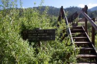
The trail head starts by crossing a river.
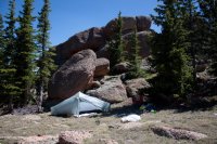
My camp, nestled up against the rock to try and find a little wind protection.
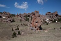
This pinnacle is huge, if you look closely you'll see two hikers at the base to put it in perspective.
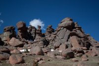
More cool rock formations.
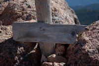
It's official I am at the top! 12,431 feet
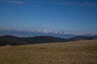
The views from the ridge. I believe that is Torreys 14er (if I was using the peak finder app correctly )
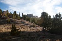 Sun dawning on the ridge where I was camped.
The Ute Creek trail starts out in the 9,000ft range and climbs 3,800ft to Bison Peak ridge in 6 miles. I'm not going to lie this trail kicked my butt hard! It's steep and the unrelenting climb in the altitude with a 27# pack ground me into the earth. I thought several times I might not reach the summit. As I passed 11,000 feet I was reduced to taking 10 steps and then catching my breath. I repeated this cycle for what seemed like hours. Finally I reached the ridge of the summit.
I had been concerned about water supply at the summit and had been restricting my water in case the snow patches I had been told were there 5 days ago had melted in our recent hot days. But once I crested the ridge there where plenty of 30-40 foot patches to melt for water. I sat in the shade and drank plentifully. I ate a little and just chilled. Then I got to business of setting up camp. Everything is work at 12,000ft, even fluffing your down bag feels like work. Next i filled trash compacter bag I use as a pack liner with snow and got busy making water. By now 2 hours had passed and I was feeling a lot better. I grabbed my camera and bottle of water and headed for the summit.
The summit is an impressive boulder field. I picked my way up to the top and was rewarded when i finally found the summit sign and metal box with a summit register. I proudly jotted my name on the paper and took in the views. Back at camp i made dinner and small fire. I thought I might get some good star shots up here but as the sun set the clouds rolled in. No stars tonight. I was beat and turned in for the night. Sunday morning i made my coffee and breakfast and broke camp. I was on the trail heading down by 7:15a.m. Going down gives the quads and knees a tough work out but it was easy peasy for the lungs on the way down. My legs were tired from yesterdays ascent and I cursed every time the trail dare take a slight uphill curve. Soon enough i was back at my car, exhausted, and proud. It was no 14er but a hell of a start for this Florida girl.

The trail head starts by crossing a river.

My camp, nestled up against the rock to try and find a little wind protection.

This pinnacle is huge, if you look closely you'll see two hikers at the base to put it in perspective.

More cool rock formations.

It's official I am at the top! 12,431 feet

The views from the ridge. I believe that is Torreys 14er (if I was using the peak finder app correctly )
 Sun dawning on the ridge where I was camped.
Last edited:
