hikerboy
Member
- Joined
- Aug 31, 2015
- Messages
- 35
the benton mackaye trail runs 286 miles from springer mountain in georgia thru the smokies ,ending at davenport gap.named after one of the founders of the appalachian trail, it provides a wilder alternative to the appalachian trail, which starts at the same place and meets again after the smokies. last year i hiked it for the first time, then continued on the at north to bland virginia, 700 miles over the course of 2 months. this past spring i decided to go back down south and hike it again.
here is my trip report:
4/5/15 i arrive in gainesville,ga, get picked up by hiker hostel, and shuttled to the hostel to stay overnight. i got to meet some of the prospective thrus including 2 french canadians who told me they were from quebec. when i asked what part of france that was, they seemed confused.
noone knew about the benton mackaye trail, and didnt know who benton mackaye was.
hiker hostel is a very nice, clean place.its the second time ive stayed there , and they're really nice people.

4/6/14- 12.5 miles
hiker hostel shuttles us up to fs42 parking lot. i decided to forego my third trip back to the summit of springer and save myself a couple of miles. i had heard from trebor, who wanted to come meet me my first night and camp overnight at toccoa river bridge.its 14.7 miles from the terminus,with an extra .8 to get to the terminus from the lot.as it was rainy as well, i didnt think it wise to be doing a 16 mile first day.
so i decided to head north straight from the parking lot stay on the at till the final crossing and save myself about 3 miles. i got back on the bmt at long creek falls. i saw no one at all on the trail until i got closer to the river, where i heard some voices.although i had never met him before, i knew trebor as soon as i saw him.we laughed, he told me the fishing was great, but we had meat tonight.he had brought out steaks and beer. as it was now steadily raining, we headed to his truck, parked in the lot nearby, cooked in the back of the truck, and ate inside.the steaks were awesome, and the conversation even better.
we headed back to our tents in the rain and said our goodnights. it was a really great way for me to begin my hike. thank you soooo much for coming out trebor.
and steak became a regular part of my diet after that.
4/7/15 toccoa river bridge to payne gap
we got up the next morning to some light sprinkles and cloudy skies, i walked with trebor back to his truck,i thanked him for his kindness, and headed up the trail. i had thought this was gonna be an easy 12 miles but made a mistake by not bringing enough water from the spring by the river. soon after i started hiking, the clouds began to break up, the sun came out,, and it became rather warm. i remembered water being plentiful last year, but as it turns out, this is one of the driest sections of the trail. it also included to modest climbs up wallallah and licklog mtns, so i was spent by the time i got to the gap. had a dinner of ramen, nido and bacon.drank as much as i could.


4/8/15 payne gap to fall branch falls 14.5 miles
this was another day i had planned on being easy. i remembered the 4 mile road walk late in the day last year was brutal, so i planned on camping at shallowford bridge, but when i got there i really couldnt find any place suitable to tent, so i ended up doing the road walk, although i had taken my time anticipating a lo miles day, but now had to push a bit to get to the falls by dark. i stopped at toccoa riverside restaurant and got a soda, and then walked the rest of the way to the falls. this was one of the few sites this year that i stayed at last year.
its a pretty site right next to a stream almost directly above the falls.
4/9/15 falls branch falls to hwy 76 blue ridge 8.4 miles
another beautiful sunny day. originally i had planned on getting in and out of blue ridge for resupply on the same day, but i didnt reach the hwy till 1:30 and decided id stay the night. i got a hitch from a local couple who took me right to days inn,. when i asked about the weather, he said they were predicting heavy storms the next day. being it was my birthday friday, i booked the room for 2 nights, decided not to hike in the rain on my birthday and eat well.
after checking in , i noticed a guy with a backpack looking for his own room, asked him if he was hiking the benton mackaye, he told me he was. i introduced myself, and he smiled , told me he was sheepdog, and he was with superman, both of whom i knew from sgt rocks hiking hq.
went to dinner that night with superman, and got a nice piece of prime rib at the village restaurant.they were staying out of the rain the following day, as well, and heading out on saturday.
4/10/15 blue ridge 0 miles
it rained.
i ate and slept.
planned on shuttling back to the trail with sheepdog and superman.
ate and slept.
4/11/15 us hwy 76 to hatley gap 11.1 miles
days inn shuttled me, superman and sheepdog back to the trailhead. it was a beautiful sunny day, perfect for hiking, we passed through upper cherry log as well as indian rock shelter, one of 2 shelters on the entire bmt.superman and sheepdog had never met before this hike, and we joked pretty much through the day. we were following superman's slower pace, but i didnt mind the company and i was in no hurry,and so decided to camp with them at hatley gap.


4/12/15 hatley gap to dyer gap fs64 8.0 miles
a short day. superman was taking a break every 20 minutes, and i didn't mind slowing down somewhat, i was in no hurry this trip, and we were having some hysterical conversations, supeerman was a bit upset with his phone only working in spanish. we ran into the few other hikers on the bmt, a young couple from europe who we never saw again, and ned from maine, who i would run into several times before my hike was through. he camped with us that night
we camped at a stream a little after dyer gap.


4/13/15 dyer gap to double spring gap. 12.3 miles
relatively flat section, its a nice stretch that runs through mostly rhododendron forests with mossy boulders and streams. we had thought about heading down at watson gap to jacks river country store, but when we called them, we found out it was closed, so we hiked on. nedtrailnamened hiked with us and again we camped together at double spring gap. it was here i had an incident with the zipper on my rainfly. i was able to tape the fly closed, but decided to go into ducktown after thunder rock the next day and see if i could fix it.
4/14/15 double spring gap to thunder rock campground 10.9 miles
this is a beautiful section of the trail that also has its first steep climb, from double spring gap, 900 feet up in the first mile over big frog. everything is lush and green with pine duff trails to hike on. sky is overcast and we here theres rain moving into the area. sheepdog and superman are going to get a room in ducktown for the night, and he calls to see if he can get a hold of bearpaw for a shuttle. bearpaw, a marine who lives nearby in benton, picks us up, asks our plan, and then tells us he'll put us up at his place until the rain moves through and slackpack us every day in the interim. its an offer we cant refuse, so he takes us to hardees for burgers and shakes, then piggly wiggly, and finally to his home, where we meet his wife and beautiful 3 yr old daughter, who reminds me a lot of my own granddaughter. we go out for dinner at a local steakhouse, the ribeye was great.
bearpaw sets up a couple of cots and a hammock for us in the basement, we shower, and are thankful to be out of the rain, well fed and warm.


4/15/15 thunder rock to lost creek campground 13.3 miles
bearpaw drops us off at the trailhead and we slackpack the next 13 miles. this is a really pretty stretch of trail,it was raining lightly when we started but the rest of the day was simply overcast with some drizzle.
we got to lost creek around 4:30, with bearpaw there to meet us and bring us back home. he cooked up some steaks and potatoes when we got back, and listened to he and superman trade war stories.
bearpaw offers to lend me one of his tents,six moons design, so i wouldnt have to worry about mine. as it was gonna rain for the next week or so, i thanked him for it.although smaller than my own, it was enough to keep me and my gear dry, even in a windy rainstorm on newton bald.
the next day, heavy storms were forecast, so we planned a short slackpack

4/16/15 lost creek campgraound to hiawassee fly and tackle 4.1 iles.
superman decided he needed a rest, so bearpaw dropped me and sheepdog off at lost creek.the stretch from lost creek to reliance, imho, is one of the prettiest of the entire trail. it runs alongside a stream that flows through a limestone gorge, plush with mossy boulders and ferns, a scene out of avatar. sheepdog stepped right over a copperhead he didnt see,sitting right in the middle of the trail.it didnt pay us any mind and we continued down the lush forest trail. it started raining more heavily and by the time we got to reliance, it was pouring and we were wetter than swimming.the last forest road crossing had 2 ft of water, we didnt bother taking our shoes off, just stomped right through. we got to hiawassee outfitters before 1pm, superman and bearpaw's wife and superman were to pick us up at 1:3o but didnt show up till 2:30. we took refuge in the bunkroom, which was left open and unlocked, where we zqueezed the water out of our clothes, and waited. we stopped at reliance fly and tackle to pick up my only maildrop(which is=t turned out ws unnecessary), and headed back to bearpaw's.after hot showers, me supe and sheepdog treated bearpaws family to dinner. bearpaw told us it was supposed to be heavy storms for 3 more days and told us to just stay with him, but i insisted we couldnt impose any longer, that we'd be moving on.superman and sheepdog agreed, and the next day we would head back to reliance.


4/17/15 -4/18/15 reliance to hwy 68 12 miles
bearpaw dropped us off at reliance fly and tackle. as it was gonna continue to rain for the next few days, we booked the cabin for friday and saturday, intending to hike out sunday.we ran into nedtrailnamened who had stayed at the cabin the night before.we took a zero for the day and settled in.
the next day,another leisurely slackpack over a tough stretch of trail the same stretch that was kicking rasty's butt last year his first day out with me, but a heck of a lot easier without a full pack. it rained all day, and when bearpaw picked us up, he shuttled us back into town so we could get some food for the cabin. we heard the forecast called for heavy storms again that sunday, so we decided to just book the cabin for sunday, when we would just zero before continuing.we had steaks,bacon, eggs, snacks, coffee, beer, and good company.
but not really what i originally had in mind.


4/18 hwy 68 to unicoi gap
bearpaw met us and drove us to buck bald for some nice 360 views,then we drove down the toccoa river to watch kayakers, then headed back to the cabin


4/19/15 reliance 0 miles.
Heavy rain all day.eat sleep tv

4/20/15 unicoi gap to ambulance 3.6 miles
the weather was finally breaking and it was moving day. bearpaw couldnt pick us up till after work, so we just hung out at the cabin till he arrived. he came around 3:30 and drove us back up to unicoi gap. we thanked him for all his kindness and hospitality and headed up the trail to an old forest road where theres an abandoned ambulance with a spring box near the ruins of an old two story rock home, and camped for the night.
4/21/15 ambulance to brookshire creek. 13.0 miles
this was a tough day, as the area has a lot of blowdown,very few blazes,stream fords, and a trail that in some places was nothing more than a faint trace of matted leaves.we got to brookshire creek around 5;30pm but i wasnt crazy about the site, told them i was gonna head down the trail a bit more to find a flat spot, which i did in another miles. that night, i knew that our hike together was coming to an end. sheepdog was going home the next weekend, and superman was hiking a bit too slow for my liking.i cooked up some ramen and hit the hay early.


4/22/15 brookshire creek to "secret campsite" 10.8 miles
i woke to another sunny, beautiful dawn, and lingered tll the guys caught up with me. sheepdog mentioned to me superman and he were going to stay at green cove motel overnight. i told him i didnt know if i would as well, would wait till we got there, so we hiked on to tellico river road, it was early in the day, and with the weather so nice, i wanted to take advantage, so we snacked at the picnic tables at the parking turnout, then we said our goodbyes, and they walked down the road towards the motel.
i hiked on till i came to a campsite about .1 off the trail that me and rasty had lunched at. its a pretty sight with a beautiful stream that falls over giant mossy boulders.i washed up, cooked dinner, and felt raindrops. a brief while later the heavens opened once again and it poured hard for about an hour. i started to wonder if i should've stayed with the guys when it abruptly ended, and a little while later the skies once again cleared.


superman and sheepdog leaving at green cove marked the approximate halfway point of my hike,a far different hike than i had originally envisioned.
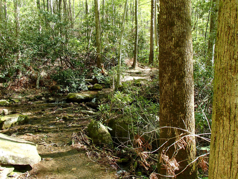
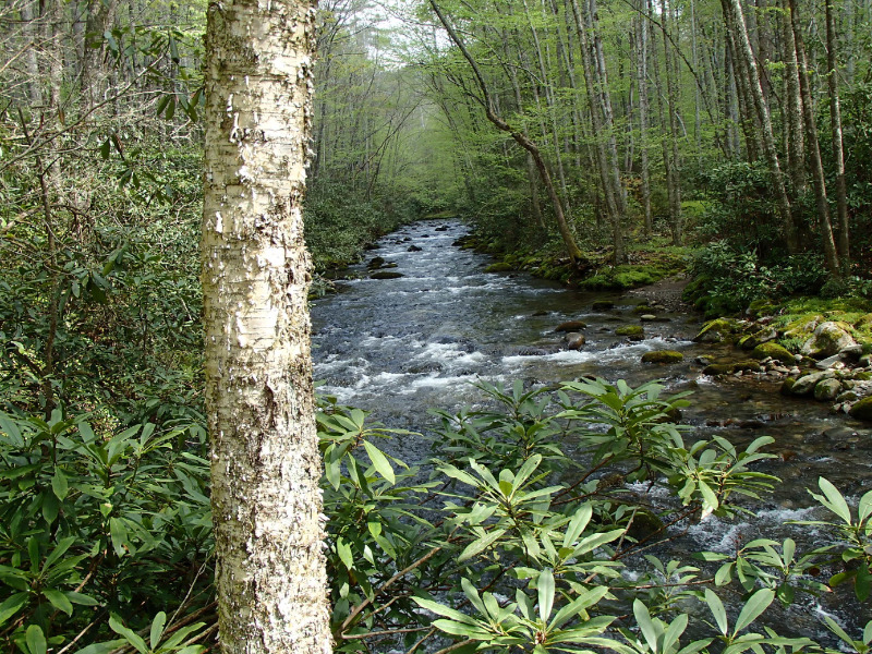
although hiking with them was a lot slower than my normal pace, i not only enjoyed their company, but it slowed me down a lot and i was able to pay more attention to the millions of miracles occurring all around me. i was in awe at the diversity of the plant life, and couldnt believe the number of different types of plants, ferns and flowers i saw.at the start, the forest was still a bit brown ,but with all the rain, and the sun reemerging finally, the wildflowers were in bloom, butterflies abounded, and i felt like i was hiking in a scene from avatar in beautiful,lush green forest.
when people ask about views, i always get confused. i love the "green tunnel" as much as i love the mountain vistas, and this trail has both. one day youre on a ridgeline walk, the next youre back in the forest, with more streams, creeks, cascades and luscious lush green mossy boulders.
so now i was back on my own, and open to whatever the next day would bring.
4/23 secret campsite to cold spring gap 9.3 miles
i woke to birdsong and sunshine. i lingered around the falls while i got water and had a safety meeting. i thought about whether the guys were continuing we had made some tentative plans early on to meet up with a few of the hobos from hiking hq at whigg meadow. i packed up my tent, still wet from the rainstorm the night before,and headed up toward whigg meadow. it was windy, and the sun was out, so i hung out my tent and sleeping bag to dry completely, sat down and ate some lunch. as it was beautiful out and i was only looking to hike a few more miles that day,i decided to linger and see if the guys were following. by 2:30, i finally decided to get going, and found out later they were both off the trail.it was all me, at least for now.


4/24/15 cold spring gap to tapoco lodge 14.3 miles
another day of warm sunshine. after the usual shake for breakfast and some bacon, i was once again on the ridge and the views were spectacular!!

this was the new slickrock creek bypass,and the trails were in much better condition than they were in the "heart of darkness" i had just hiked through the past few days.i approached the top of haoe bald and it wsa there i ran into tipi walter.when he saw me he said "you look familiar" and as i smiled,said"tipi walter, i'm hikerboy!" he showed me his new ul setup including a 3 lb hilleberg. he examined my pack closely, knew he could never carry 18 days f food in it, and we both laughed. chatted a bit, he told me he had hiked for a while with willow, a lady friend, one of the few people that thru'd the bmt so far this year. he heard storms were moving in again,and he was gonna see if he could hole up somewhere. he told me a bit about the trail ahead, we said goodbye, and i went off towards the hangover, where i was treated to more 360 views


coming off the hangover and getting back on the trail wsa a bit confusing and i had to go back and forth 3 times before i was sure i was on the right trail going down. it was a fairly steep downhill the rest of the day, and i finally made out through the trees some signs of civilization , and walked down the road till i got to tapoco lodge. i had called ahead so was already prepared for the high prices, checked into a room, and took a nice hot shower. went to dinner and while i was eating my $46 ribeye, nedtrailnamened from maine walked over. jhe had had to get off and go into tellico for a coupla days as a tree limb had fallen on his tent in the night and bent one of the poles of his hubba, so we had to wait to get them overnighted. he was headed out the next day, but i was going to wait out sunday's expected storms before heading to fontana.


as it turned out, the storms never came, it was a bright beautiful sunny day.although i was annoyed to have made the decision to stay, and never wanting to waste a good day, i figured the rooms already paid for,so i may as well enjoy myself. i was able to get my laundry done, i went on their computer and booked my smokies permits, then ate and drank down by the river and watched kayakers the rest of the day.
tapoco lodge at $179++/night is pricey, but the service was outstanding, everyone warm and friendly.there is no resupply available however,although i intended to resupply at fontana village anyway.
that night i booked a room for the following night at fontana inn.


4/26/15 tapoco lodge to fontana inn 10 mi
i had breakfast and checked out early as i remembered this stretch of trail from last year with rasty.,and even though the miles were short , i had a coupla thousand feet of elevation gain over steep ups and downs ahead of me, wanted to get to fontana early to resupply and check into fontana inn.
the yellow creek ridge trail was part of the original at before fontana dam was built.
last year, the trail had only been flagged but not cleared in most areas, this year the trail was in great shape, except for the occasional blowdon, i got to a fs crossing and saw a tree down across from where i thought the trail went, looked at my map and the guidebook, and started down the fs to the left. it wasnt long till it led to a dead end water source, and i realized my mistake. when i got back to the owned tree, i saw a bmt marker on the underside, and knew the trail was right behind it. this is the beginning of the stairway too heaven, a series of steep ups and downs with some steps in places, leading to the top of yellow creek mtn , and its a ball buster.when i got to the top of the mtn, i checked my phone for service, as i hadnt had a chance to speak to my mom in a while, had no service for the past week. i got a signal and sat down, called mom, called my daughters, and checked in with my boss at work. i ate some crackers, and started down the trail again the downhill became quite steep , came back over some steps again, and came to the same tree down across the trail i had passed some 45 minutes before! i had just hiked 2 miles in the wrong direction!!!
after some fine cussing, i just started back up again. once your over the mtn, the downside into fontana village is very pretty. finally got to fontana inn around 4pm. checked in and decided to just resupply in the am before i hit the smokies.had another ribeye for dinner.
up next the smokies


4/27/15 fontana inn to possum hollow campsite 88 11 miles
checked out early and headed down to the general store to resupply. i ran into a few nobos crossing the dam , and split off onto the lost cove trail.
when i made my reservations at tapoco lodge, i planned on staying at mt sterling again for my last night, but found 3 days already marked full. this meant a coupla extra days to kill so i split the trip into two permits-- 4 nights, into cherokee overnight, and then 3 more nights and out.this allowed me to again set an agenda different than last years hike, and chose all different sites,except for sterling.
the lakeshore trail is very pretty with many views of the lake through the trees, as well as touching the shore several times.
i set up camp alone,and gathered a little wood to make a small fire to get rid of the biting flies that have been a constant nuisance anytime i stopped moving. while foraging for wod, i came acros a nice size rattler wondering what i was up to.


4/28/15 possum hollow to chambers creek 16.2 miles
another bright sunny morning, let my tent dry out from overnight condensation, then headed down the trail. i passed through the abandoned town of proctor, where rasty and i had camped last year. i made a shake and ate some bacon on the porch of the calhoun house, and then headed on.so far ive seen noone at all on the trail.this would be my highest mileage day on the hike so far, but the terrain was flat and the trail easy,


4/29/15 chambers creek to mill creek. 13.8 miles.
another easy day over mild terrain, through the tunnel along the highway to nowhere. i got to mill creek around 4pm and reunited with nedtrailnamened. another nice day through beautiful forest, with several stream crossings.


4/30/15 mill creek to newton bald 16.3 mi
we started early as it was going to be a long day, and we had heard bad weather might be moving in late afternoon.the trail starts at 2540' at mill creek, climbs to 4250' at the noland divide trail, then drops back down to martins gap at 2360' and finally climbs up to newton bald at 5000'
its a beautiful stretch with huge old growth trees, and water plentiful until martins gap.nedtrailname ned and i saw noone on the trail at all.it started clouding up and the wind picked up as we climbed.
newton bald campsite lay a coupla hundred feet from the summit in a gap that looked swept clean.we set up our tents just as it was starting to rain, cooked a quick dinner, and figured on leaving early the next morning and get into cherokee, so we said goodnight.the temperature dropped and all night the wind kept blowing,maybe 30-40 mph, enough that i worried my stakes wouldnt hold, but bearpaw's tent managed to keep me dry through the night.


5/1/15 newton bald to smokemont campground/cherokee 5.6 miles
when we awoke, , the rain had stopped , but the wind was blowing hard and cold so we just packed up and headed down the trail. the night before we msde reservations at microtel motel in cherokee, and arranged for a taxi to pick us up at smokemont at 12 noon. we had 5 hours to do 5.6 miles. i bolted down hill to get warm, and trucked down the trail for an hour before is topped to make a shake and a snack. the sun had come out, and it felt good,felt warm . the trail was an easy downhill, but didnt seem as steep as i remembered last year, but i remembered hitting that part later in the day last year, so figured i must have been pushing harder. i waited around for nedtrailnamened, but finally decided to head on. i finally came to a stream, with a small cascade, also unfamiliar, decided to wash up , make some coffee, and wait for nedtrailnamened again. around 10:30 i decided to move on, and wait for him at the road. i got to a parking area that looked totally unfamiliar, and when i checked my map, saw i was 2 miles farther south than i should have been. i had taken the wrong trail down! from newton bald, you stay on the newton bald trail down to the road. instead, i had taken the mingus creek trail. i laughed at my mistake, and figured , oh well, id already done the other trail last year, and the stream i had snacked at was very pretty so i just got the opportunity to hike a new blue blaze, and i still had time to hike the 2 miles up to smokemont to meet nedtrailnamened and the taxi. i started walking up 441 and about 5 minutes later, and unfamiliar suv honked and waved at me, pulled over , and nedtrailnamened jumped out, waved me over. he had hitched a ride from a german engineer who was in the atlanta for a conference took a day to go up to clingman's dome, and was headed back to atlanta. he drove us into cherokee, we called the taxi to cancel, and walked the last mile to the motel.its a good place to stay with a food lion and family dollar nearby for resupply.
tony the guy at the desk remembered me from last year, we checked in, i did my laundry, showered and changed. the motel runs a shuttle to the casino, and i wanted a good ribeye, so we took it to harrah's for dinner.
as nedtrailnamened had a different reservation schedule for the next few days, i told him i wasnt leaving till afternoon so i could have a good lunch, as i only had a few miles to hike , so we said goodbye that night.


5/2/15 smokemont campground to upper chasteen creek 4.5 miles
my smokies reservation was for lower chasteen creek, only 2 miles from smokemont, so i planned on not checking out till noon, so i could get another good meal in me before i hit the trail.i chatted with tony, the motel desk clerk, he thanked me for coming back again, and asked if i'd be coming back next year. i told them it was highly likely, as i love this trail, and wanted to do it again. i had been looking for a more solitary experience, but as it turned out, i spent less nights alone than not.he then asked one of the girls who worked there to take his truck and drive me to smokemont. i thanked him and told him i looked forward to seeing him again. i called standing bear and arranged a shuttle to ashville, so i could get a bus and get back home.
after getting dropped off at the trailhead at smokemont, i took my time getting to the campsite, which was adjacent to a pretty stream. i saw a tent set up and met a young couple, who was camped there to fish. we chatted a bit, they told me they were headed to another stream to fish taht day, and would see me later that night. after having a little lunch, i decided the site was way to close to the road, and would probably crowd up later so i hiked on to the next site farther up the creek.when i got to upper chasteen creek it was empty except for a couple camped right by the stream, so i chose a flat spot near a fire ring on the adjacent hill and set up for the night. i never met the other couple, cooked dinner and read "the deerslayer" in my tent till it got dark. i lit a small fire to get rid of the bugs, and when it went out, i hit the tent for the night.


5/3/14 upper chasten creek to mcgee spring campsite 8.3 mi
the morning saw me climbing back to the ridge before dipping down to enloe creek and then back up to the ridge. i had some breakfast at enloe creek under the bridge by the creek, where i had camped the year before, enjoying the sunshine and thee surroundings.
the mcgee spring campsite is .9 mi on the hyatt ridge trail, and within a few minutes i came upon a beautiful campsite in a gap, lush verdant aquatic plants surrounded the spring, and set within a grove of old growth hemlocks.i again lit a small fire to get rid of the nagging biting flies, that stayed each afternoon till dusk.i cooked while the sun went down, and got treated to a sky full of stars before i retired to my tent.
that night i though a lot about the hike, how it was completely different than what i had planned, but nonetheless, was a wonderful trip so far. i had one more night to sleep in the forest before my return home.


5/4/15 mcgee spring to mt sterling 14.5 miles
my last full day on the trail. i got up early , had a quick liquid breakfast and started back down the hyatt ridge trail to where it rejoined the bmt and started down towards straight fork and then back up to laurel gap shelter. as i climbed i got my first scent of balsam fir, which always turns me on. huge old growth trees the floor of the forest carpeted with tiny white flowers, like a fresh snowfall, and the forest took on a fragrant magical feel. as i got to the shelter, it was clouding over, and it looked like i was in for some more storms.i had been hoping for a clear night on mt sterling, but i guess mother nature had different plans. i ate lunch at the shelter and continued up the trail, so that i could set up before the weather moved in. its a fairly flat stretch between the shelter and mt sterling, with a primeval forest to walk through, fragrant with the christmassy scent of balsam. when i got to the fire tower, there were 2 guys,30ish, overnighting that had their tents already set up. i pitched mine nearby and we talked about the trail. this was their longest hike to date a 3 day 2 night trip, and they had loved it, were hoping to get out for longer hikes.the skies cleared, and we were treated to a beautiful moonrise. they enjoyed my trail stories by a campfire, and as the embers died away, we said goodnight and retired to our tents.


5/5/15 mt sterling to big creek 6.1 miles
i woke up to see the guys already packing up. i went up to the fire tower to see the sunrise, and smiled, thinking back on my hike, and how different it had turned out. i had just over 6 miles to finish the trail and another 6 or so to get to standing bear. i packed up and headed down the trail,in no hurry, as i was surrounded in beauty.
its an amazing piece of forest, and i would take frequent safety breaks, not wanting my hike to come to an end.i had half a thought to turn around and walk back to springer, but the weather was turning warmer, i had enjoyed my hike, and wanted to save some "vacation time " for another long walk in the fall. i eventually came out of the boreal forest, back into the hardwoods, and rhodos. and came to the northern terminus.


some final thoughts about my hike.
the best plan is no plan.
what planning does for me is give me flexibility in adapting to changing circumstances. as a life long blue blazer, im not locked in to any agenda, and ,even in the smokies ,i didnt adhere to my reservations all the time.
but i stay open to every new day, every new opportunity, and when im on the trail, just deal with it a day at a time. i had originally wanted to be alone for the duration of the hike, but as it turned out with the weather, i had a wonderful time with bearpaw,superman, sheepdog, and nedtrailnamened. i know we are all now lifelong friends, and only through meeting entirely by chance. i am thankful that my hike took the turns it did.when we hiked together , we did fairly lo mileage days. this didnt trouble me at all, as it slowed me down a bit, and i just enjoyed the ride. as i was not continuing up the at the way i did last year, i had plenty of time to spend on this trail itself. and the company was a great way to ride out the weather.
the trail can teach you so much to take home with you. teach you how happy you can be with so little.teach you to simplify your life. teach you to deal with whatever comes your way. teach you that things always work out, although it may not seem so at the time, teach you to embrace the suck, that those are the events that define us,the tough times are the events we grow from. teach you that things dont always come easy, but are worthwhile nonetheless. teach you that most people are kind, compassionate and helpful, when you are respectful and thankful , an attitude that carries over into every aspect of my life.
i am grateful for everything thats happened in my life, both good and bad, because i wouldnt be in the place i am, if anything were different.
i'm hoping to hike the bmt again next year, solo, and again look for that solitary experience. but if i end up meeting more of you along the way, well,what can i say? its all good.
Featured image for home page:

here is my trip report:
4/5/15 i arrive in gainesville,ga, get picked up by hiker hostel, and shuttled to the hostel to stay overnight. i got to meet some of the prospective thrus including 2 french canadians who told me they were from quebec. when i asked what part of france that was, they seemed confused.
noone knew about the benton mackaye trail, and didnt know who benton mackaye was.
hiker hostel is a very nice, clean place.its the second time ive stayed there , and they're really nice people.
4/6/14- 12.5 miles
hiker hostel shuttles us up to fs42 parking lot. i decided to forego my third trip back to the summit of springer and save myself a couple of miles. i had heard from trebor, who wanted to come meet me my first night and camp overnight at toccoa river bridge.its 14.7 miles from the terminus,with an extra .8 to get to the terminus from the lot.as it was rainy as well, i didnt think it wise to be doing a 16 mile first day.
so i decided to head north straight from the parking lot stay on the at till the final crossing and save myself about 3 miles. i got back on the bmt at long creek falls. i saw no one at all on the trail until i got closer to the river, where i heard some voices.although i had never met him before, i knew trebor as soon as i saw him.we laughed, he told me the fishing was great, but we had meat tonight.he had brought out steaks and beer. as it was now steadily raining, we headed to his truck, parked in the lot nearby, cooked in the back of the truck, and ate inside.the steaks were awesome, and the conversation even better.
we headed back to our tents in the rain and said our goodnights. it was a really great way for me to begin my hike. thank you soooo much for coming out trebor.
and steak became a regular part of my diet after that.
4/7/15 toccoa river bridge to payne gap
we got up the next morning to some light sprinkles and cloudy skies, i walked with trebor back to his truck,i thanked him for his kindness, and headed up the trail. i had thought this was gonna be an easy 12 miles but made a mistake by not bringing enough water from the spring by the river. soon after i started hiking, the clouds began to break up, the sun came out,, and it became rather warm. i remembered water being plentiful last year, but as it turns out, this is one of the driest sections of the trail. it also included to modest climbs up wallallah and licklog mtns, so i was spent by the time i got to the gap. had a dinner of ramen, nido and bacon.drank as much as i could.
4/8/15 payne gap to fall branch falls 14.5 miles
this was another day i had planned on being easy. i remembered the 4 mile road walk late in the day last year was brutal, so i planned on camping at shallowford bridge, but when i got there i really couldnt find any place suitable to tent, so i ended up doing the road walk, although i had taken my time anticipating a lo miles day, but now had to push a bit to get to the falls by dark. i stopped at toccoa riverside restaurant and got a soda, and then walked the rest of the way to the falls. this was one of the few sites this year that i stayed at last year.
its a pretty site right next to a stream almost directly above the falls.
4/9/15 falls branch falls to hwy 76 blue ridge 8.4 miles
another beautiful sunny day. originally i had planned on getting in and out of blue ridge for resupply on the same day, but i didnt reach the hwy till 1:30 and decided id stay the night. i got a hitch from a local couple who took me right to days inn,. when i asked about the weather, he said they were predicting heavy storms the next day. being it was my birthday friday, i booked the room for 2 nights, decided not to hike in the rain on my birthday and eat well.
after checking in , i noticed a guy with a backpack looking for his own room, asked him if he was hiking the benton mackaye, he told me he was. i introduced myself, and he smiled , told me he was sheepdog, and he was with superman, both of whom i knew from sgt rocks hiking hq.
went to dinner that night with superman, and got a nice piece of prime rib at the village restaurant.they were staying out of the rain the following day, as well, and heading out on saturday.
4/10/15 blue ridge 0 miles
it rained.
i ate and slept.
planned on shuttling back to the trail with sheepdog and superman.
ate and slept.
4/11/15 us hwy 76 to hatley gap 11.1 miles
days inn shuttled me, superman and sheepdog back to the trailhead. it was a beautiful sunny day, perfect for hiking, we passed through upper cherry log as well as indian rock shelter, one of 2 shelters on the entire bmt.superman and sheepdog had never met before this hike, and we joked pretty much through the day. we were following superman's slower pace, but i didnt mind the company and i was in no hurry,and so decided to camp with them at hatley gap.
4/12/15 hatley gap to dyer gap fs64 8.0 miles
a short day. superman was taking a break every 20 minutes, and i didn't mind slowing down somewhat, i was in no hurry this trip, and we were having some hysterical conversations, supeerman was a bit upset with his phone only working in spanish. we ran into the few other hikers on the bmt, a young couple from europe who we never saw again, and ned from maine, who i would run into several times before my hike was through. he camped with us that night
we camped at a stream a little after dyer gap.
4/13/15 dyer gap to double spring gap. 12.3 miles
relatively flat section, its a nice stretch that runs through mostly rhododendron forests with mossy boulders and streams. we had thought about heading down at watson gap to jacks river country store, but when we called them, we found out it was closed, so we hiked on. nedtrailnamened hiked with us and again we camped together at double spring gap. it was here i had an incident with the zipper on my rainfly. i was able to tape the fly closed, but decided to go into ducktown after thunder rock the next day and see if i could fix it.
4/14/15 double spring gap to thunder rock campground 10.9 miles
this is a beautiful section of the trail that also has its first steep climb, from double spring gap, 900 feet up in the first mile over big frog. everything is lush and green with pine duff trails to hike on. sky is overcast and we here theres rain moving into the area. sheepdog and superman are going to get a room in ducktown for the night, and he calls to see if he can get a hold of bearpaw for a shuttle. bearpaw, a marine who lives nearby in benton, picks us up, asks our plan, and then tells us he'll put us up at his place until the rain moves through and slackpack us every day in the interim. its an offer we cant refuse, so he takes us to hardees for burgers and shakes, then piggly wiggly, and finally to his home, where we meet his wife and beautiful 3 yr old daughter, who reminds me a lot of my own granddaughter. we go out for dinner at a local steakhouse, the ribeye was great.
bearpaw sets up a couple of cots and a hammock for us in the basement, we shower, and are thankful to be out of the rain, well fed and warm.
4/15/15 thunder rock to lost creek campground 13.3 miles
bearpaw drops us off at the trailhead and we slackpack the next 13 miles. this is a really pretty stretch of trail,it was raining lightly when we started but the rest of the day was simply overcast with some drizzle.
we got to lost creek around 4:30, with bearpaw there to meet us and bring us back home. he cooked up some steaks and potatoes when we got back, and listened to he and superman trade war stories.
bearpaw offers to lend me one of his tents,six moons design, so i wouldnt have to worry about mine. as it was gonna rain for the next week or so, i thanked him for it.although smaller than my own, it was enough to keep me and my gear dry, even in a windy rainstorm on newton bald.
the next day, heavy storms were forecast, so we planned a short slackpack
4/16/15 lost creek campgraound to hiawassee fly and tackle 4.1 iles.
superman decided he needed a rest, so bearpaw dropped me and sheepdog off at lost creek.the stretch from lost creek to reliance, imho, is one of the prettiest of the entire trail. it runs alongside a stream that flows through a limestone gorge, plush with mossy boulders and ferns, a scene out of avatar. sheepdog stepped right over a copperhead he didnt see,sitting right in the middle of the trail.it didnt pay us any mind and we continued down the lush forest trail. it started raining more heavily and by the time we got to reliance, it was pouring and we were wetter than swimming.the last forest road crossing had 2 ft of water, we didnt bother taking our shoes off, just stomped right through. we got to hiawassee outfitters before 1pm, superman and bearpaw's wife and superman were to pick us up at 1:3o but didnt show up till 2:30. we took refuge in the bunkroom, which was left open and unlocked, where we zqueezed the water out of our clothes, and waited. we stopped at reliance fly and tackle to pick up my only maildrop(which is=t turned out ws unnecessary), and headed back to bearpaw's.after hot showers, me supe and sheepdog treated bearpaws family to dinner. bearpaw told us it was supposed to be heavy storms for 3 more days and told us to just stay with him, but i insisted we couldnt impose any longer, that we'd be moving on.superman and sheepdog agreed, and the next day we would head back to reliance.
4/17/15 -4/18/15 reliance to hwy 68 12 miles
bearpaw dropped us off at reliance fly and tackle. as it was gonna continue to rain for the next few days, we booked the cabin for friday and saturday, intending to hike out sunday.we ran into nedtrailnamened who had stayed at the cabin the night before.we took a zero for the day and settled in.
the next day,another leisurely slackpack over a tough stretch of trail the same stretch that was kicking rasty's butt last year his first day out with me, but a heck of a lot easier without a full pack. it rained all day, and when bearpaw picked us up, he shuttled us back into town so we could get some food for the cabin. we heard the forecast called for heavy storms again that sunday, so we decided to just book the cabin for sunday, when we would just zero before continuing.we had steaks,bacon, eggs, snacks, coffee, beer, and good company.
but not really what i originally had in mind.
4/18 hwy 68 to unicoi gap
bearpaw met us and drove us to buck bald for some nice 360 views,then we drove down the toccoa river to watch kayakers, then headed back to the cabin
4/19/15 reliance 0 miles.
Heavy rain all day.eat sleep tv
4/20/15 unicoi gap to ambulance 3.6 miles
the weather was finally breaking and it was moving day. bearpaw couldnt pick us up till after work, so we just hung out at the cabin till he arrived. he came around 3:30 and drove us back up to unicoi gap. we thanked him for all his kindness and hospitality and headed up the trail to an old forest road where theres an abandoned ambulance with a spring box near the ruins of an old two story rock home, and camped for the night.
4/21/15 ambulance to brookshire creek. 13.0 miles
this was a tough day, as the area has a lot of blowdown,very few blazes,stream fords, and a trail that in some places was nothing more than a faint trace of matted leaves.we got to brookshire creek around 5;30pm but i wasnt crazy about the site, told them i was gonna head down the trail a bit more to find a flat spot, which i did in another miles. that night, i knew that our hike together was coming to an end. sheepdog was going home the next weekend, and superman was hiking a bit too slow for my liking.i cooked up some ramen and hit the hay early.
4/22/15 brookshire creek to "secret campsite" 10.8 miles
i woke to another sunny, beautiful dawn, and lingered tll the guys caught up with me. sheepdog mentioned to me superman and he were going to stay at green cove motel overnight. i told him i didnt know if i would as well, would wait till we got there, so we hiked on to tellico river road, it was early in the day, and with the weather so nice, i wanted to take advantage, so we snacked at the picnic tables at the parking turnout, then we said our goodbyes, and they walked down the road towards the motel.
i hiked on till i came to a campsite about .1 off the trail that me and rasty had lunched at. its a pretty sight with a beautiful stream that falls over giant mossy boulders.i washed up, cooked dinner, and felt raindrops. a brief while later the heavens opened once again and it poured hard for about an hour. i started to wonder if i should've stayed with the guys when it abruptly ended, and a little while later the skies once again cleared.
superman and sheepdog leaving at green cove marked the approximate halfway point of my hike,a far different hike than i had originally envisioned.
although hiking with them was a lot slower than my normal pace, i not only enjoyed their company, but it slowed me down a lot and i was able to pay more attention to the millions of miracles occurring all around me. i was in awe at the diversity of the plant life, and couldnt believe the number of different types of plants, ferns and flowers i saw.at the start, the forest was still a bit brown ,but with all the rain, and the sun reemerging finally, the wildflowers were in bloom, butterflies abounded, and i felt like i was hiking in a scene from avatar in beautiful,lush green forest.
when people ask about views, i always get confused. i love the "green tunnel" as much as i love the mountain vistas, and this trail has both. one day youre on a ridgeline walk, the next youre back in the forest, with more streams, creeks, cascades and luscious lush green mossy boulders.
so now i was back on my own, and open to whatever the next day would bring.
4/23 secret campsite to cold spring gap 9.3 miles
i woke to birdsong and sunshine. i lingered around the falls while i got water and had a safety meeting. i thought about whether the guys were continuing we had made some tentative plans early on to meet up with a few of the hobos from hiking hq at whigg meadow. i packed up my tent, still wet from the rainstorm the night before,and headed up toward whigg meadow. it was windy, and the sun was out, so i hung out my tent and sleeping bag to dry completely, sat down and ate some lunch. as it was beautiful out and i was only looking to hike a few more miles that day,i decided to linger and see if the guys were following. by 2:30, i finally decided to get going, and found out later they were both off the trail.it was all me, at least for now.
4/24/15 cold spring gap to tapoco lodge 14.3 miles
another day of warm sunshine. after the usual shake for breakfast and some bacon, i was once again on the ridge and the views were spectacular!!
this was the new slickrock creek bypass,and the trails were in much better condition than they were in the "heart of darkness" i had just hiked through the past few days.i approached the top of haoe bald and it wsa there i ran into tipi walter.when he saw me he said "you look familiar" and as i smiled,said"tipi walter, i'm hikerboy!" he showed me his new ul setup including a 3 lb hilleberg. he examined my pack closely, knew he could never carry 18 days f food in it, and we both laughed. chatted a bit, he told me he had hiked for a while with willow, a lady friend, one of the few people that thru'd the bmt so far this year. he heard storms were moving in again,and he was gonna see if he could hole up somewhere. he told me a bit about the trail ahead, we said goodbye, and i went off towards the hangover, where i was treated to more 360 views
coming off the hangover and getting back on the trail wsa a bit confusing and i had to go back and forth 3 times before i was sure i was on the right trail going down. it was a fairly steep downhill the rest of the day, and i finally made out through the trees some signs of civilization , and walked down the road till i got to tapoco lodge. i had called ahead so was already prepared for the high prices, checked into a room, and took a nice hot shower. went to dinner and while i was eating my $46 ribeye, nedtrailnamened from maine walked over. jhe had had to get off and go into tellico for a coupla days as a tree limb had fallen on his tent in the night and bent one of the poles of his hubba, so we had to wait to get them overnighted. he was headed out the next day, but i was going to wait out sunday's expected storms before heading to fontana.
- 4/25/15 tapoco lodge 0 miles
as it turned out, the storms never came, it was a bright beautiful sunny day.although i was annoyed to have made the decision to stay, and never wanting to waste a good day, i figured the rooms already paid for,so i may as well enjoy myself. i was able to get my laundry done, i went on their computer and booked my smokies permits, then ate and drank down by the river and watched kayakers the rest of the day.
tapoco lodge at $179++/night is pricey, but the service was outstanding, everyone warm and friendly.there is no resupply available however,although i intended to resupply at fontana village anyway.
that night i booked a room for the following night at fontana inn.
4/26/15 tapoco lodge to fontana inn 10 mi
i had breakfast and checked out early as i remembered this stretch of trail from last year with rasty.,and even though the miles were short , i had a coupla thousand feet of elevation gain over steep ups and downs ahead of me, wanted to get to fontana early to resupply and check into fontana inn.
the yellow creek ridge trail was part of the original at before fontana dam was built.
last year, the trail had only been flagged but not cleared in most areas, this year the trail was in great shape, except for the occasional blowdon, i got to a fs crossing and saw a tree down across from where i thought the trail went, looked at my map and the guidebook, and started down the fs to the left. it wasnt long till it led to a dead end water source, and i realized my mistake. when i got back to the owned tree, i saw a bmt marker on the underside, and knew the trail was right behind it. this is the beginning of the stairway too heaven, a series of steep ups and downs with some steps in places, leading to the top of yellow creek mtn , and its a ball buster.when i got to the top of the mtn, i checked my phone for service, as i hadnt had a chance to speak to my mom in a while, had no service for the past week. i got a signal and sat down, called mom, called my daughters, and checked in with my boss at work. i ate some crackers, and started down the trail again the downhill became quite steep , came back over some steps again, and came to the same tree down across the trail i had passed some 45 minutes before! i had just hiked 2 miles in the wrong direction!!!
after some fine cussing, i just started back up again. once your over the mtn, the downside into fontana village is very pretty. finally got to fontana inn around 4pm. checked in and decided to just resupply in the am before i hit the smokies.had another ribeye for dinner.
up next the smokies
4/27/15 fontana inn to possum hollow campsite 88 11 miles
checked out early and headed down to the general store to resupply. i ran into a few nobos crossing the dam , and split off onto the lost cove trail.
when i made my reservations at tapoco lodge, i planned on staying at mt sterling again for my last night, but found 3 days already marked full. this meant a coupla extra days to kill so i split the trip into two permits-- 4 nights, into cherokee overnight, and then 3 more nights and out.this allowed me to again set an agenda different than last years hike, and chose all different sites,except for sterling.
the lakeshore trail is very pretty with many views of the lake through the trees, as well as touching the shore several times.
i set up camp alone,and gathered a little wood to make a small fire to get rid of the biting flies that have been a constant nuisance anytime i stopped moving. while foraging for wod, i came acros a nice size rattler wondering what i was up to.
4/28/15 possum hollow to chambers creek 16.2 miles
another bright sunny morning, let my tent dry out from overnight condensation, then headed down the trail. i passed through the abandoned town of proctor, where rasty and i had camped last year. i made a shake and ate some bacon on the porch of the calhoun house, and then headed on.so far ive seen noone at all on the trail.this would be my highest mileage day on the hike so far, but the terrain was flat and the trail easy,
4/29/15 chambers creek to mill creek. 13.8 miles.
another easy day over mild terrain, through the tunnel along the highway to nowhere. i got to mill creek around 4pm and reunited with nedtrailnamened. another nice day through beautiful forest, with several stream crossings.
4/30/15 mill creek to newton bald 16.3 mi
we started early as it was going to be a long day, and we had heard bad weather might be moving in late afternoon.the trail starts at 2540' at mill creek, climbs to 4250' at the noland divide trail, then drops back down to martins gap at 2360' and finally climbs up to newton bald at 5000'
its a beautiful stretch with huge old growth trees, and water plentiful until martins gap.nedtrailname ned and i saw noone on the trail at all.it started clouding up and the wind picked up as we climbed.
newton bald campsite lay a coupla hundred feet from the summit in a gap that looked swept clean.we set up our tents just as it was starting to rain, cooked a quick dinner, and figured on leaving early the next morning and get into cherokee, so we said goodnight.the temperature dropped and all night the wind kept blowing,maybe 30-40 mph, enough that i worried my stakes wouldnt hold, but bearpaw's tent managed to keep me dry through the night.
5/1/15 newton bald to smokemont campground/cherokee 5.6 miles
when we awoke, , the rain had stopped , but the wind was blowing hard and cold so we just packed up and headed down the trail. the night before we msde reservations at microtel motel in cherokee, and arranged for a taxi to pick us up at smokemont at 12 noon. we had 5 hours to do 5.6 miles. i bolted down hill to get warm, and trucked down the trail for an hour before is topped to make a shake and a snack. the sun had come out, and it felt good,felt warm . the trail was an easy downhill, but didnt seem as steep as i remembered last year, but i remembered hitting that part later in the day last year, so figured i must have been pushing harder. i waited around for nedtrailnamened, but finally decided to head on. i finally came to a stream, with a small cascade, also unfamiliar, decided to wash up , make some coffee, and wait for nedtrailnamened again. around 10:30 i decided to move on, and wait for him at the road. i got to a parking area that looked totally unfamiliar, and when i checked my map, saw i was 2 miles farther south than i should have been. i had taken the wrong trail down! from newton bald, you stay on the newton bald trail down to the road. instead, i had taken the mingus creek trail. i laughed at my mistake, and figured , oh well, id already done the other trail last year, and the stream i had snacked at was very pretty so i just got the opportunity to hike a new blue blaze, and i still had time to hike the 2 miles up to smokemont to meet nedtrailnamened and the taxi. i started walking up 441 and about 5 minutes later, and unfamiliar suv honked and waved at me, pulled over , and nedtrailnamened jumped out, waved me over. he had hitched a ride from a german engineer who was in the atlanta for a conference took a day to go up to clingman's dome, and was headed back to atlanta. he drove us into cherokee, we called the taxi to cancel, and walked the last mile to the motel.its a good place to stay with a food lion and family dollar nearby for resupply.
tony the guy at the desk remembered me from last year, we checked in, i did my laundry, showered and changed. the motel runs a shuttle to the casino, and i wanted a good ribeye, so we took it to harrah's for dinner.
as nedtrailnamened had a different reservation schedule for the next few days, i told him i wasnt leaving till afternoon so i could have a good lunch, as i only had a few miles to hike , so we said goodbye that night.
5/2/15 smokemont campground to upper chasteen creek 4.5 miles
my smokies reservation was for lower chasteen creek, only 2 miles from smokemont, so i planned on not checking out till noon, so i could get another good meal in me before i hit the trail.i chatted with tony, the motel desk clerk, he thanked me for coming back again, and asked if i'd be coming back next year. i told them it was highly likely, as i love this trail, and wanted to do it again. i had been looking for a more solitary experience, but as it turned out, i spent less nights alone than not.he then asked one of the girls who worked there to take his truck and drive me to smokemont. i thanked him and told him i looked forward to seeing him again. i called standing bear and arranged a shuttle to ashville, so i could get a bus and get back home.
after getting dropped off at the trailhead at smokemont, i took my time getting to the campsite, which was adjacent to a pretty stream. i saw a tent set up and met a young couple, who was camped there to fish. we chatted a bit, they told me they were headed to another stream to fish taht day, and would see me later that night. after having a little lunch, i decided the site was way to close to the road, and would probably crowd up later so i hiked on to the next site farther up the creek.when i got to upper chasteen creek it was empty except for a couple camped right by the stream, so i chose a flat spot near a fire ring on the adjacent hill and set up for the night. i never met the other couple, cooked dinner and read "the deerslayer" in my tent till it got dark. i lit a small fire to get rid of the bugs, and when it went out, i hit the tent for the night.
5/3/14 upper chasten creek to mcgee spring campsite 8.3 mi
the morning saw me climbing back to the ridge before dipping down to enloe creek and then back up to the ridge. i had some breakfast at enloe creek under the bridge by the creek, where i had camped the year before, enjoying the sunshine and thee surroundings.
the mcgee spring campsite is .9 mi on the hyatt ridge trail, and within a few minutes i came upon a beautiful campsite in a gap, lush verdant aquatic plants surrounded the spring, and set within a grove of old growth hemlocks.i again lit a small fire to get rid of the nagging biting flies, that stayed each afternoon till dusk.i cooked while the sun went down, and got treated to a sky full of stars before i retired to my tent.
that night i though a lot about the hike, how it was completely different than what i had planned, but nonetheless, was a wonderful trip so far. i had one more night to sleep in the forest before my return home.
5/4/15 mcgee spring to mt sterling 14.5 miles
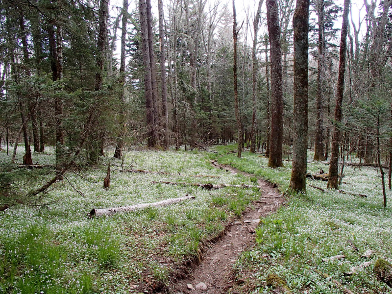
my last full day on the trail. i got up early , had a quick liquid breakfast and started back down the hyatt ridge trail to where it rejoined the bmt and started down towards straight fork and then back up to laurel gap shelter. as i climbed i got my first scent of balsam fir, which always turns me on. huge old growth trees the floor of the forest carpeted with tiny white flowers, like a fresh snowfall, and the forest took on a fragrant magical feel. as i got to the shelter, it was clouding over, and it looked like i was in for some more storms.i had been hoping for a clear night on mt sterling, but i guess mother nature had different plans. i ate lunch at the shelter and continued up the trail, so that i could set up before the weather moved in. its a fairly flat stretch between the shelter and mt sterling, with a primeval forest to walk through, fragrant with the christmassy scent of balsam. when i got to the fire tower, there were 2 guys,30ish, overnighting that had their tents already set up. i pitched mine nearby and we talked about the trail. this was their longest hike to date a 3 day 2 night trip, and they had loved it, were hoping to get out for longer hikes.the skies cleared, and we were treated to a beautiful moonrise. they enjoyed my trail stories by a campfire, and as the embers died away, we said goodnight and retired to our tents.
5/5/15 mt sterling to big creek 6.1 miles
i woke up to see the guys already packing up. i went up to the fire tower to see the sunrise, and smiled, thinking back on my hike, and how different it had turned out. i had just over 6 miles to finish the trail and another 6 or so to get to standing bear. i packed up and headed down the trail,in no hurry, as i was surrounded in beauty.
its an amazing piece of forest, and i would take frequent safety breaks, not wanting my hike to come to an end.i had half a thought to turn around and walk back to springer, but the weather was turning warmer, i had enjoyed my hike, and wanted to save some "vacation time " for another long walk in the fall. i eventually came out of the boreal forest, back into the hardwoods, and rhodos. and came to the northern terminus.
some final thoughts about my hike.
the best plan is no plan.
what planning does for me is give me flexibility in adapting to changing circumstances. as a life long blue blazer, im not locked in to any agenda, and ,even in the smokies ,i didnt adhere to my reservations all the time.
but i stay open to every new day, every new opportunity, and when im on the trail, just deal with it a day at a time. i had originally wanted to be alone for the duration of the hike, but as it turned out with the weather, i had a wonderful time with bearpaw,superman, sheepdog, and nedtrailnamened. i know we are all now lifelong friends, and only through meeting entirely by chance. i am thankful that my hike took the turns it did.when we hiked together , we did fairly lo mileage days. this didnt trouble me at all, as it slowed me down a bit, and i just enjoyed the ride. as i was not continuing up the at the way i did last year, i had plenty of time to spend on this trail itself. and the company was a great way to ride out the weather.
the trail can teach you so much to take home with you. teach you how happy you can be with so little.teach you to simplify your life. teach you to deal with whatever comes your way. teach you that things always work out, although it may not seem so at the time, teach you to embrace the suck, that those are the events that define us,the tough times are the events we grow from. teach you that things dont always come easy, but are worthwhile nonetheless. teach you that most people are kind, compassionate and helpful, when you are respectful and thankful , an attitude that carries over into every aspect of my life.
i am grateful for everything thats happened in my life, both good and bad, because i wouldnt be in the place i am, if anything were different.
i'm hoping to hike the bmt again next year, solo, and again look for that solitary experience. but if i end up meeting more of you along the way, well,what can i say? its all good.
Featured image for home page:
Last edited: