Bee Hive Traverse

I've done most of it with some added stuff to make a loop. Great hike. Some pics and TR here.

Edit: tried to send you a pm but not working...I'll just say it's not that close to the vest and was published in a particular backpack related mag a few years ago. There's plenty of info out there to do it.
 
Last edited:
I've done most of it with some added stuff to make a loop. Great hike. Some pics and TR here.

Edit: tried to send you a pm but not working...I'll just say it's not that close to the vest and was published in a particular backpack related mag a few years ago. There's plenty of info out there to do it.

Thanks very much. I'll look through back issues. You can also contact me here it so inclined Thanks much.

http://over50outdoors.org/contact/
 
I've done most of it with some added stuff to make a loop. Great hike. Some pics and TR here.

Edit: tried to send you a pm but not working...I'll just say it's not that close to the vest and was published in a particular backpack related mag a few years ago. There's plenty of info out there to do it.

Found it:
http://www.backpacker.com/stories/national-parks-capitol-reef/

The GPS track is long gone but I think I can put it together from the blurry map in the article. Google has back issues to 2009. This one is from 2011.
 
I saw that same trip on the guiding site. Would love to know more about the route. 32 miles is a good length for a 4 day trip.
 
Awesome. I've hiked in CR NP a bunch of times and has often wondered about routes across the reef but never bothered to put something together.
 
I tried to PM it to you @SKLund, but you have your profile locked down and it won't let me, so I'll post the file here. This is the one from Backpacker from Capitol Gorge to Pleasant Creek.

Hope this helps.
 

Attachments

  • Capitol Reef National Park Capitol Gorge to Pleasant Creek.kmz
    10 KB · Views: 332
I saw that same trip on the guiding site. Would love to know more about the route. 32 miles is a good length for a 4 day trip.

I've gotten some solid info from folks on this site and expect to do something with it in the Fall. What I don't know yet because there are a number of options on this particular route.
 
Looks like a fun route.

Sidenote -- I find it odd that the author feels the need to compare the route to the John Muir Trail in that blog post. Maybe it plays to his audience; not sure. He evidently got the notion initially from the guide/originator who declares early in post that the traverse is "just as nice as the John Muir Trail”.

I'm not really sure how one compares a 17-mile scramble through Capitol Reef to a 211-mile trail through the High Sierras. Seems like apples and oranges. Or... an apple vs a bag of oranges. :)

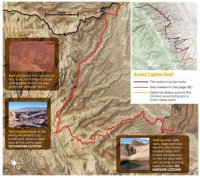
I can tell already from what I can discern from topo maps and a very fuzzy picture from an old online article from Backpacker Magazine, that this is a Southeast to Northwest transit that comes out at Cohab Canyon or Grand Wash and ends with ice cream in Fruita. Not trivial by any means (except the ice cream) and it appears to be puzzled out over time. The author, Steve Howe, lives in Torrey, guides clients through it, and I expect that no one will get this route by any other way but the old fashioned way. The fuzzy follows. The black line is the incomplete Beehive, the yellow works around steeps and deep pools, the red is a day hike or overnight. I think this is a late Winter to Spring trip. I wouldn't try it when the pools are dry.

capitolreefindd.jpg
 
I was wrong. It comes out at Spring Canyon based on eyeballing the map.
 
@SKLund, I'm actually aiming to do this route as well as I've been piecing together info on it over the last couple of weeks, but not the full 32 miles of Spring Canyon to Pleasant Creek Route that was published by the magazine aforementioned. I'm aiming to just do the 17 miles or so from Grand Wash to Capitol Gorge which is what Michael Lanza and a friend of his did with Steve Howe's route beta, which I think it the section they've called the Beehive Traverse. Despite Michael's post and Backpacker publishing info about that route and beyond (courtesy of Steve which you can't fault because after all, he's the one who apparently pioneered it), I'd be willing to bet that it still sees few, if anybody else, traverse that route outside of Steve's guided trips from year to year.

Next month I'm aiming to do the Capitol Gorge-Pleasant Creek route as an overnight loop, and then hopefully fit the actual Beehive Traverse in, possibly the week after, or later this fall myself. My in-laws live in Torrey now and so since I've essentially married into that park, I'm hoping to become as familiar with at least all the non-technical areas as I can, and I think I'm just going to continue working through various sections moving southward as time and circumstances permit me to. I know there's one somewhat tricky and exposed spot to climb out of Bear Canyon and another exposed ledge just before descending down to the Tanks as you enter Capitol Gorge. I'm hoping to have time to scout out these more exposed spots near the beginning and end of the route when I'm down there next month in order to make sure I'd be comfortable enough with them myself. Steve also marked a waypoint where there is a short slot that when he and his crew had done it, they had to wade through chest high water that was unavoidable, but interestingly, Michael makes no mention of such a wader in his write up of that. I've actually created my own map in my Caltopo account using Steve's GPS track and all of his key waypoints and then made more precise adjustments with satellite imagery so that I can have all that cached and on the ready whenever I attempt it. That's a route with a handful of pour-offs that you need to know exactly where to look and go to safely bypass them.

I was selfishly hoping to be the first one to break a TR of it here, but maybe you'll beat me to it. Then again, If you don't mind company, maybe I could join you if the time you're looking at this fall overlaps with days I'll have off? My only concern with doing it in the fall as opposed to the spring is that fall is typically drier and so the many potholes throughout the washes along the way may almost all be dried up come fall, where as in Spring, it's more likely that water sources would be more abundant. Then again, Michael said in his write up that they only found water in two spots and it was April when he did it.

Looks like you have some good intel and connections there. Slowly I am piecing it together from multiple sources including this one. I consider the route that Mr. Howe guides as proprietary information (it's not) but that is my operational definition and will proceed that way. This means I either go with people who know it already or I puzzle it out myself. I would be happy to join you but in the near term I am committed to a an Escalante trip in April. I live in Santa Fe and I can make maybe 2 to 3 Utah trips per year.

Fall is not the best time to make a multi-day backpack into the Fold. I do however plan on visiting then to scout and do day hikes, maybe hauling water as an overnight. Generally it may take 2 or 3 trips for me to scout, map out, and do an area. Complex routes like this one are my favorites. This makes my timeline, a trip this Fall and an attempt next Spring to do the route from Pleasant Creek to Spring Canyon.

Regarding the chest wade, it you look at the fuzzy map I posted, the yellow line goes around some steep drops and water, according to the author. With all that, if we can coordinate, heck yes let's do it, whatever it is.
 
Last edited:
Keep in mind Backpacker is Backpacker and the other articles are trying to make you think you need to hire them to get you through there. If you're an experienced canyon hiker it's pretty typical fare. Don't worry about pinpointing exact routes around stuff; if there's only one way around it you'll see it when you're there. There's also a pretty well-established trail for a lot of it.

I see little appeal for the Spring Canyon section. You can easily dayhike that and if you include it you have to actually travel on the highway only a few miles into the trip. If you want more there's still 60 miles or so as the crow flies of the Fold south of Pleasant Creek.
 
I do lot's of canyon and desert hiking here in NM. That's pretty much the default terrain I find myself in most of the time. I do not know the Fold well although it is a current obsession. Do you know if anyone has traversed the whole thing? That would be sick and I get the idea that one or more of the epic through hikers in this forum have mulled it over. I see re-supply drops as the major obstacle, an expedition in itself, and that is probably wildly underestimating the task at hand.
 
There's also a pretty well-established trail for a lot of it.
Though I haven't done the whole "beehive" portion route, Ive dayhiked several stretches of it as out and backs. Haven't done the slot section that supposedly is wet. But I rarely saw trail as at least 1/2 of it is pleasant sklickrock hiking. I do remember tread, probably more game used, on the sw trending rib above Waterpocket Canyon until reaching the slickrock. This was prior to 2013. Hopefully more tread isn't developing.

April 21,2011 "Tanks Draw":
http://www.nwhikers.net/forums/viewtopic.php?t=7990608

April 17, 2013 South Rim of Waterpocket Canyon:
http://www.nwhikers.net/forums/viewtopic.php?t=8004508

Fern's Nipple alternate route connecting Grand Wash and Capitol Gorge (south to north April 14, 2010):
http://www.nwhikers.net/forums/viewtopic.php?t=7982568
 
Last edited:
Keep in mind Backpacker is Backpacker and the other articles are trying to make you think you need to hire them to get you through there. If you're an experienced canyon hiker it's pretty typical fare. Don't worry about pinpointing exact routes around stuff; if there's only one way around it you'll see it when you're there. There's also a pretty well-established trail for a lot of it.

Good to know. I don't know how much it takes to truly be experienced, but after doing a solo trip connecting Chimney Canyon, Spring Canyon, Grand Wash, Frying Pan, Cohab, and Sulphur, and several other backpacking trips and day hikes through and over similar terrain, I'm reasonably confident I could probably do this one with no more risk than what I've already done by the sounds of it.

Can I ask, just how long is the wader slot? How long did it take to get through it? Also, how spicy was the climb up and over the pass out of Bear Canyon? Same question for that little shelf that bypasses the pouroff that drops down to the Tanks into Capitol Gorge? Any more exposed and riskier than the pouroff bypass in lower Spring Canyon?

I may just try to pull this off as an overnighter one week next month in addition to the other one I have lined up. It sounds like there may be more people who've traveled this route than I thought.
I don't remember anything being very difficult or sketchy (assuming a light pack and appropriate footwear ie not stiff hard-rubber boots) aside from one bypass of a drop that is kinda steep and exposed (and it was raining), but there are big cracks that make it not bad, and IIRC you could do a longer but easier bypass on the other side. The wade is no biggie.
 
Similar threads
Thread starter Title Forum Replies Date
Kullaberg63 Gore high traverse Backpacking 11
radioradio Sad Cowboy Traverse - A Week in Escalante Backpacking 12
J Death Valley Natl. Pk. A Black Mtns and Canyons Traverse Nov 30, 2021 Hiking & Camping 2
TheMountainRabbit Northern Wind River Traverse (Bridger/Fitzpatrick Wilderness) - September 2021 Backpacking 16
Hiker Seth Single day Presidential traverse Hiking & Camping 5
G Zion (half) traverse in April '21? Trip Planning 31
Dustynails0 Beartooth lake to East rosebud traverse Trip Planning 6
stretch Most Scenic Route to Traverse the Gros Ventre? Trip Planning 17
B Dark Canyon - Young's to Lean-to Traverse Trip Planning 3
NorthwestWanderer The Bailey Range Traverse | An 8 Day Olympic National Park Epic Backpacking 15
danger02ward 2020 Spring Beatout traverse Winter Sports 18
J North Cascades National Park Black and Corteo Peaks Traverse Aug 21-23, 2007 Retro Backpacking 3
fossana Bat Mountain traverse (Funeral Mountains) Hiking & Camping 5
WasatchWill Beehive Traverse - Through the Heart of Capitol Reef's Waterpocket Fold Backpacking 39
3 Grand Canyon Traverse - Map? Trip Planning 0
Ugly Snowy Dawn Traverse on Deer Ridge Hiking & Camping 6
McKee80 Glacier NP Multi Segment Quasi Northern Traverse Backpacking 19
J Zion Traverse in early December Trip Planning 19
ram The Inspiration Traverse - Part 4 Backpacking 4
ram The Inspiration Traverse - Part 3 Backpacking 6
ram The Inspiration Traverse - Part 2 Backpacking 2
ram The Inspiration Traverse Backpacking 19
andyjaggy Sawtooths Traverse and Stashing a Bike General Discussion 5
Stickerbumper Zion Traverse Memorial Day Weekend - Shuttle Meet Up (Members Only) 0
J Canyonlands Needles Dist.: Crosscanyon Backpack Traverse April 10-15, 2016 Backpacking 1
steve Backpacking the Zion Traverse Backpacking 12
hatchcanyon The Great Traverse Off Road 9
LarryBoy Beartooths - East/West Traverse (any/all advice welcome!) Trip Planning 15
steve Wind Rivers Traverse - Backpacking 90 miles in the Wind Rivers Backpacking 102
LarryBoy Wasatch North-South Traverse General Discussion 5
Vegan.Hiker Great Range Traverse Part 1 Backpacking 19
L July Zion Traverse and Narrows Backpacking Itinerary Trip Planning 18
IntrepidXJ Colorado National Monument Traverse II Backpacking 3
scatman Wildcat Ridge Traverse - May 25, 2014 Hiking & Camping 6
markj Zion Traverse- April 23-26. Backpacking 8
IntrepidXJ Colorado National Monument Traverse Hiking & Camping 6
Bob Sawtooth Mountains Traverse Resource Discussions 7
Bob Wind River Mountains - South to North High Traverse Resource Discussions 0
as Wind Rivers Traverse Backpacking 11
ram Ptarmigan Traverse- Day 5- July 26th 2013 Backpacking 3
ram Ptarmigan Traverse- Day 4- July 25th 2013 Backpacking 1
ram Ptarmigan Traverse- Day 3- July 24th 2013 Backpacking 1
ram Ptarmigan Traverse- Day 2- July 23nd 2013 Backpacking 1
ram Ptarmigan Traverse- Day 1- July 22nd 2013 Backpacking 4
Bob Wind River Range Traverse Backpacking 14
lostlandscapes Zion Traverse: April 26-28, 2013 Backpacking 7
xjblue Southern Utah Traverse 2009 Off Road 15
Bob Sawtooth Wilderness, Idaho - North to South Traverse Backpacking 25

Similar threads

Back
Top