Bee Hive Traverse

FYI...that link in the OP no longer goes to a complete write up. Mr. Lanza has taken the bulk of his blog and closed it off from free access. You now have to pay subscription to even see his pictures and read his story, along with so many others, even when so many of his article likes this one, don't reveal any detailed route beta, or they are often areas already regulated by permits, etc. Anyway...I digress.

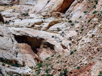
Can any of you who've come down (or went up) the pour-off above the Tanks in doing this route, take my picture below and draw a line along the exact shelf you cling to when bypassing the pour-off and connecting on to the rock slide? Yes, I'm looking at you @Brendan S and @John Morrow. Please and thank you.
upload_2018-2-23_19-18-24.png

I've got this penciled in for late April with another experienced friend. I may still go on to scout up there before hand to make sure it's not too sketchy and exposed for my comfort level, but in case I don't, I'd really like to know what I'd be committing myself to when I get to that point, as I understand this to be the crux of the whole route...Also, how tricky is the "Butt Crack" further up this drainage? I understand there is some chimneying or stemming involved to come down it. What's the best way to deal with packs coming down that part? I'd welcome a PM for any more beta that can be provided. I've got the route all mapped out in detail already and seems fairly straight forward up until these sections. Then I've got the wader to consider with the option to bail out the other way and bypass all of this entirely, but I also understand that would miss the most scenic section of the whole route.
 
FYI...that link in the OP no longer goes to a complete write up. Mr. Lanza has taken the bulk of his blog and closed it off from free access. You now have to pay subscription to even see his pictures and read his story, along with so many others, even when so many of his article likes this one, don't reveal any detailed route beta, or they are often areas already regulated by permits, etc. Anyway...I digress.

Can any of you who've come down (or went up) the pour-off above the Tanks in doing this route, take my picture below and draw a line along the exact shelf you cling to when bypassing the pour-off and connecting on to the rock slide? Yes, I'm looking at you @Brendan S and @John Morrow. Please and thank you.

View attachment 61923

I've got this penciled in for late April with another experienced friend. I may still go on to scout up there before hand to make sure it's not too sketchy and exposed for my comfort level, but in case I don't, I'd really like to know what I'd be committing myself to when I get to that point, as I understand this to be the crux of the whole route...Also, how tricky is the "Butt Crack" further up this drainage? I understand there is some chimneying or stemming involved to come down it. What's the best way to deal with packs coming down that part? I'd welcome a PM for any more beta that can be provided. I've got the route all mapped out in detail already and seems fairly straight forward up until these sections. Then I've got the wader to consider with the option to bail out the other way and bypass all of this entirely, but I also understand that would miss the most scenic section of the whole route.
I still am way interested in this route. I am thinking of contacting Mr Howe and try to get a package by deal if I can bring folks on board. Won't happen for me this year however. This route is still held pretty tight.

Goodluçk. Hope you get it done.


Sent from my E6810 using Tapatalk
 
Last edited:
The other way to do this leg is to skip the domes and go out to theGolden Throne to Fern's nipple on the Kayenta. Still quite scenic.
My memory, Will, is it is the higher sloping ledge in the pic. I honestly don't fullyremember but there is more there in the way of a reasonable secure route thanthe pic suggests.
The butt crack is strictly a stem move. It is at a low angle which makes it both weird and easier. Big pack should be fine.
I have a pic of it here:
https://www.flickr.com/photos/23557848@N03/sets/72157626459227507
also pictured is a better angle of the traverse showing the width of the ledge
Here's the route to Pleasant Creek out of Cap Gorge (incomplete)
https://www.flickr.com/photos/23557848@N03/sets/72157633272533691/with/8661250058/
starts with pic titles ascending the southern rim
 
Yikes, I am a broken record. I already sent links in an earlier post. Forgot about it. Didn't realize this thread has been pondered so long!
 
I still am way interested in this route. I am thinking of contacting Mr Howe and try to get a package by deal if I can bring folks on board. Won't happen for me this year however. This route is still held pretty tight.

Goodluçk. Hope you get it done.


Sent from my E6810 using Tapatalk[/QUOT
@SKLund, I'm actually aiming to do this route as well as I've been piecing together info on it over the last couple of weeks, but not the full 32 miles of Spring Canyon to Pleasant Creek Route that was published by the magazine aforementioned. I'm aiming to just do the 17 miles or so from Grand Wash to Capitol Gorge which is what Michael Lanza and a friend of his did with Steve Howe's route beta, which I think it the section they've called the Beehive Traverse. Despite Michael's post and Backpacker publishing info about that route and beyond (courtesy of Steve which you can't fault because after all, he's the one who apparently pioneered it), I'd be willing to bet that it still sees few, if anybody else, traverse that route outside of Steve's guided trips from year to year.

Next month I'm aiming to do the Capitol Gorge-Pleasant Creek route as an overnight loop, and then hopefully fit the actual Beehive Traverse in, possibly the week after, or later this fall myself. My in-laws live in Torrey now and so since I've essentially married into that park, I'm hoping to become as familiar with at least all the non-technical areas as I can, and I think I'm just going to continue working through various sections moving southward as time and circumstances permit me to. I know there's one somewhat tricky and exposed spot to climb out of Bear Canyon and another exposed ledge just before descending down to the Tanks as you enter Capitol Gorge. I'm hoping to have time to scout out these more exposed spots near the beginning and end of the route when I'm down there next month in order to make sure I'd be comfortable enough with them myself. Steve also marked a waypoint where there is a short slot that when he and his crew had done it, they had to wade through chest high water that was unavoidable, but interestingly, Michael makes no mention of such a wader in his write up of that. I've actually created my own map in my Caltopo account using Steve's GPS track and all of his key waypoints and then made more precise adjustments with satellite imagery so that I can have all that cached and on the ready whenever I attempt it. That's a route with a handful of pour-offs that you need to know exactly where to look and go to safely bypass them.

I was selfishly hoping to be the first one to break a TR of it here, but maybe you'll beat me to it. Then again, If you don't mind company, maybe I could join you if the time you're looking at this fall overlaps with days I'll have off? My only concern with doing it in the fall as opposed to the spring is that fall is typically drier and so the many potholes throughout the washes along the way may almost all be dried up come fall, where as in Spring, it's more likely that water sources would be more abundant. Then again, Michael said in his write up that they only found water in two spots and it was April when he did it.
 
The other way to do this leg is to skip the domes and go out to theGolden Throne to Fern's nipple on the Kayenta. Still quite scenic.
My memory, Will, is it is the higher sloping ledge in the pic. I honestly don't fullyremember but there is more there in the way of a reasonable secure route thanthe pic suggests.
The butt crack is strictly a stem move. It is at a low angle which makes it both weird and easier. Big pack should be fine.
I have a pic of it here:
https://www.flickr.com/photos/23557848@N03/sets/72157626459227507
also pictured is a better angle of the traverse showing the width of the ledge
Here's the route to Pleasant Creek out of Cap Gorge (incomplete)
https://www.flickr.com/photos/23557848@N03/sets/72157633272533691/with/8661250058/
starts with pic titles ascending the southern rim

Thanks. I did PC up and over to CG last year, staying a night up high along the way. Love it up there! Now to just make this connection from GW up and over into CG.
 
Similar threads
Thread starter Title Forum Replies Date
Kullaberg63 Gore high traverse Backpacking 11
radioradio Sad Cowboy Traverse - A Week in Escalante Backpacking 12
J Death Valley Natl. Pk. A Black Mtns and Canyons Traverse Nov 30, 2021 Hiking & Camping 2
TheMountainRabbit Northern Wind River Traverse (Bridger/Fitzpatrick Wilderness) - September 2021 Backpacking 16
Hiker Seth Single day Presidential traverse Hiking & Camping 5
G Zion (half) traverse in April '21? Trip Planning 31
Dustynails0 Beartooth lake to East rosebud traverse Trip Planning 6
stretch Most Scenic Route to Traverse the Gros Ventre? Trip Planning 17
B Dark Canyon - Young's to Lean-to Traverse Trip Planning 3
NorthwestWanderer The Bailey Range Traverse | An 8 Day Olympic National Park Epic Backpacking 15
danger02ward 2020 Spring Beatout traverse Winter Sports 18
J North Cascades National Park Black and Corteo Peaks Traverse Aug 21-23, 2007 Retro Backpacking 3
fossana Bat Mountain traverse (Funeral Mountains) Hiking & Camping 5
WasatchWill Beehive Traverse - Through the Heart of Capitol Reef's Waterpocket Fold Backpacking 39
3 Grand Canyon Traverse - Map? Trip Planning 0
Ugly Snowy Dawn Traverse on Deer Ridge Hiking & Camping 6
McKee80 Glacier NP Multi Segment Quasi Northern Traverse Backpacking 19
J Zion Traverse in early December Trip Planning 19
ram The Inspiration Traverse - Part 4 Backpacking 4
ram The Inspiration Traverse - Part 3 Backpacking 6
ram The Inspiration Traverse - Part 2 Backpacking 2
ram The Inspiration Traverse Backpacking 19
andyjaggy Sawtooths Traverse and Stashing a Bike General Discussion 5
Stickerbumper Zion Traverse Memorial Day Weekend - Shuttle Meet Up (Members Only) 0
J Canyonlands Needles Dist.: Crosscanyon Backpack Traverse April 10-15, 2016 Backpacking 1
steve Backpacking the Zion Traverse Backpacking 12
hatchcanyon The Great Traverse Off Road 9
LarryBoy Beartooths - East/West Traverse (any/all advice welcome!) Trip Planning 15
steve Wind Rivers Traverse - Backpacking 90 miles in the Wind Rivers Backpacking 102
LarryBoy Wasatch North-South Traverse General Discussion 5
Vegan.Hiker Great Range Traverse Part 1 Backpacking 19
L July Zion Traverse and Narrows Backpacking Itinerary Trip Planning 18
IntrepidXJ Colorado National Monument Traverse II Backpacking 3
scatman Wildcat Ridge Traverse - May 25, 2014 Hiking & Camping 6
markj Zion Traverse- April 23-26. Backpacking 8
IntrepidXJ Colorado National Monument Traverse Hiking & Camping 6
Bob Sawtooth Mountains Traverse Resource Discussions 7
Bob Wind River Mountains - South to North High Traverse Resource Discussions 0
as Wind Rivers Traverse Backpacking 11
ram Ptarmigan Traverse- Day 5- July 26th 2013 Backpacking 3
ram Ptarmigan Traverse- Day 4- July 25th 2013 Backpacking 1
ram Ptarmigan Traverse- Day 3- July 24th 2013 Backpacking 1
ram Ptarmigan Traverse- Day 2- July 23nd 2013 Backpacking 1
ram Ptarmigan Traverse- Day 1- July 22nd 2013 Backpacking 4
Bob Wind River Range Traverse Backpacking 14
lostlandscapes Zion Traverse: April 26-28, 2013 Backpacking 7
xjblue Southern Utah Traverse 2009 Off Road 15
Bob Sawtooth Wilderness, Idaho - North to South Traverse Backpacking 25

Similar threads

Back
Top