This is amazing advice, thank you all! Taken your advice and have the beginnings of a new route focused to the east of the Stillwater.
"Beartooth Plateau"
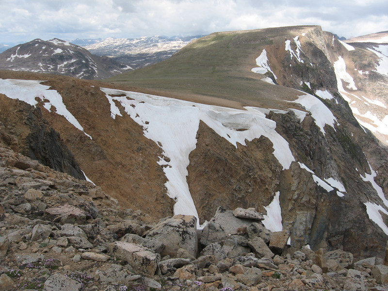
On my second ever backpacking trip, and first real of trail hiking experience, on our second day we climbed up from Flake Lake onto the Beartooth Plateau (We called it "Lightning Ridge" based on an obvious hazard) and came back down at Jasper Lake. Going up at the time for me was pretty rough, as I still hadn't figured out how to get in shape for these trips. Were I to do it again, I'd do it no questions asked. The views from on the ridge are amazing, and it's probably one of the best days of backpacking I've done.
That's what I'm hoping for! Million-mile views, way above treeline, the whole nine yards. High alpine has me hooked.
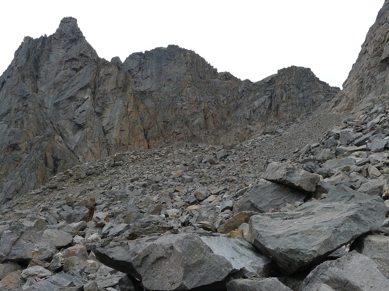
Won't say it's impassable, as there are a lot of crazy climbers in this world, but for a hiker, pretty sure it's a no go. If you look toward the right in the photo, up all those boulders and talus is a pass that will take you up to Elpestrine Lake. There is one spot that was pretty sketchy to me, otherwise it's plenty doable. Lots of unstable boulders and talus, but nothing revolutionary.
The worst of this section is that to either get to this pass, or away from this pass, you have to go up or down below Martin Lake, which is where I had my worst backpacking experience ever. It's certainly doable, and if you're in good shape and use your head while bushwhacking, it shouldn't be as terrible as what I had, but it will at best be Type 2 fun.
I tried to fit Bergschrund Lake into this trip but just couldn't... as you point out, there's no way to go through there without making the heinous ascent/descent through the Martin Lake area. Not that I'd mind making it, but if my trailhead is at Beartooth Pass, it doesn't make sense to gain and loose that much elevation if that's where my trailhead is. Having read your trip report, do you think that you weren't in the right state of mind to tackle it, or do you think it was the dehydration and insane steepness that wore you down?
If you're starting from Beartooth Pass, is it doable to make it all the way to Hwy 89 in a week? I really don't know...I'm a slow hiker (the joys of being short), so I just don't know. Depending on where you leave your car, I would think that starting on the Beartooth Highway and ending somewhere else on the Highway would make hitching pretty easy. If you hitch on 89 to a place back to the Highway, it may take multiple hitches, since most people going into Yellowstone probably aren't going all the way to Cooke City and beyond.
I plan to be there in early August...remind me, and I'll update you on the trail conditions when I get back.
I'm coming around to your line of thinking - two points on the Highway should make for a much more straight-forward hitching experience. Nothing worse than getting stuck in the middle of a big multi-hitch.
I had a route something similar planned for a 28 day loop several years ago. I've traversed 90% of the backcountry in the Winds, mostly off trail, and 10-15 mi /day in Wind's stills give me time to wet a line or two. The BT's kicked my ass !!! Think 5-10 mi a day, on a good day ..... or less.
The BT's , though flatter, are much more broken up on the small scale. What looks like miles of easy contouring is normally miles of boulder-hopping across miles of car/bus/house sized boulders, with no clear sight window ahead, that often leads to ending up in a lot of dead ends and backtracking. A 40' contour interval hides lots and lots of 35' cliffs/boulders .
In the end, I had to abort my loop and settle for wandering around for 28 days on top of the Plateau, 17 of which I never even saw a trail.
Oh, the humanity! Those 28 days sure look amazing though!
That's really good advice regarding slow travel. I had just a taste of that in the Winds - the Alpine Lakes Basin is really slow and tedious going; I imagine that's a useful comparison to the Beartooths?
In my youth, long, long ago, I was in pretty good shape but Deep Lake to Pine Creek in a week??? Ain't likely gonna happen. But a decent week trip sort of east to west is Lake Fork past Keyser Brown, First/Second Rock Lakes, and Sky Pilot. Then Donelsn, Maryott, Crystal, and Castle. There is a very nice campsite at the upper end of Castle and it's very much worth a day hike from there up past Flat Rock and make a loop around Castle Rock Glacier. Then Summerville, Eratic, Till, Gravel, Desolation, Blue Anchor, and Jordan. Then Otter and Mariane and another day trip from Mariane to Summit Mountain.
If you are burned out by then or timed out, you can exit to Chief Joseph Trailhead on the "beaten path" at that point. Otherwise, take the beaten path the other direction to Fossil, Fizzel, Looking Glass, to Rough Lake. Another day trip up through Skytops, then pop over the top to Upper and Lower Aero and exit out Zimmer Creek. Be aware, slogging through the burn around Broadwater and Curl is a pain in the posterior. Personally, that would be a 2 week trip for me. My guess is that would be about 2/3's off-trail.
I did the Chief Joseph to Lake Fork section of that and spent 9 days on it. It was a very nice trip but before GPS, we got hung up a lot.
I don't own a GPS, and will happily do a route without it. That being said, my maps are always loaded on my phone as a backup when traveling off-trail.
")
I wonder if it's possible to stay a touch higher through the Castle Rock Glacier area. It looks like it; I think the big question would be exposure of campsites.
I've taken everybody's great advice and come up with a new route. I welcome everybody's comments! In particular, the route I've put together is only ~35 miles long, plus the on-trail mileage needed to get back to the Highway (likely to Cooke City). I'm looking to add another 35 at least, as I'll have probably 7.5 or 8 hiking days. I'm thinking about turning the hike into a loop, turning to the north and looping back to my car at Beartooth Pass.
Questions:
1) Would it be a scenic letdown? A lot of the north side is forested, and I'm not necessarily keen on spending most of my time below treeline. Not that there's anything wrong with hiking in the trees, but it's a pretty different kind of hike from the high-alpine route on the Plateau on the south side of the crest.
2) Would it be possible? I sketched out a couple of possibilities to get to the FTD plateau (with Blue and Green markers). The Blue is avoidable if it's nasty, the Green are pretty much the only way I can see to get to the north side of the crest, aside from all the way down to West Rosebud (I'm looking to stay high if at all possible; see above).
I'm thinking climbing onto the FTD via a probably-heinous thousand-foot-climb from just north of Avalanche Lake. From there, cross the FTD, drop down to East Rosebud, and from there... (
something, to be continued; probably involves climbing onto the East Rosebud Plateau, dropping down past Lake Mary, over Sundance Pass, up to Black Canyon Lake, and rejoin my original route across the high ridge ["Lightning Ridge"] back to the car.)
Click here to view on CalTopo