- Joined
- Jul 23, 2013
- Messages
- 1,665
Alright, I'm now contemplating a backpacking trip along the Hole in the Rock Trail. I don't know if it's ever been done that way. Seems like everyone else has used horses and wagons while others have since hiked smaller sections and/or used high clearance 4WD and ATVs. Yes, there'd be some long stretches of road side hiking, but I'm thinking I'd like to hike it from Dance Hall Rock (where the real journey began for the pioneers) all the way out to Bluff, and keep as faithful to the original trail/route as possible. And hey, there's even an opportunity to throw in some packrafting! The total distance for the route should be in the ball park of 120 miles. I know this would be rather ambitious to try and do in 9 days and with a few different days of about 20 miles each, this is certainly the kind of trip where an ultralight gear set and mindset would be advisable.
I wouldn't be able to pull this off until next year at the soonest, but I thought it'd be good to throw out the idea now and start collecting any beta I can now from any of you who are already familiar with any sections.
Some questions I have to start off with:
1. PACKRAFTING: How feasible would packrafting across Lake Powell, from the actual Hole in the Rock across to Cottonwood be? How much time could be expected having to paddle a distance of 2-3 miles across flat water like that? Any kind of current coming through there that could pull a packraft off course? Anybody have experience with a Klymit LiteWater Dingy? Even if I could afford an Alpalcka, I'm sure I'd much rather have the lighter weight LWD in my pack, or maybe an Alpalcka Ghost?
2. WATER: Are there any other good water sources besides the springs, streams, and potholes/washes I've scoured google satellite and marked up on the map below? Are any of the ones I have marked less reliable? How is Green Water Spring or Irish Water Spring near the Castle ruins? What about Red House Spring or Collins Spring off either side of Highway 276 coming out of Clay Hills? Would Spring be a better season than Fall for increased potential water sources such snowmelt running off from higher elevations? I already expect I'll have to carry a full day's worth of water between camps for many of the days.
3. HAZARDS: Any other hazards to be aware of besides the usual flashfloods, weather, and such? I'm thinking this is a route I'd only want to attempt when I have a 7-10 day forecast of fair to good weather forecasted for the area. It should go without saying that I'd want to do this in Spring or Fall when temperatures should be more ideal.
Based on the route I've laid out below, the itinerary would look something like this:
Pre-Hike: Camp near Dance Hall Rock
Day 1: Dance Hall Rock to Hole-In-the-Rock Spring, ~15 miles
Day 2: HIR Spring to Cottonwood Canyon, ~8.5 (including packraft across Powell)
Day 3: Cottonwood Canyon to Lake Canyon, ~20 miles
Day 4: Lake Canyon to Castle Creek/Green Water Spring, ~16 miles
Day 5: Castle Creek/Green Water Spring to Dripping Canyon, ~19 miles
Day 6: Dripping Canyon to Kane Gulch, ~18 miles
Day 7: Kane Gulch to Snow Flat (The Twist), ~17 miles
Day 8: Snow Flat (The Twist) to Butler Wash, ~20 miles
Day 9 : Butler Wash to Bluff, ~6 miles
Post-hike: Lunch in Bluff, stay a night and/or get picked up and go home.
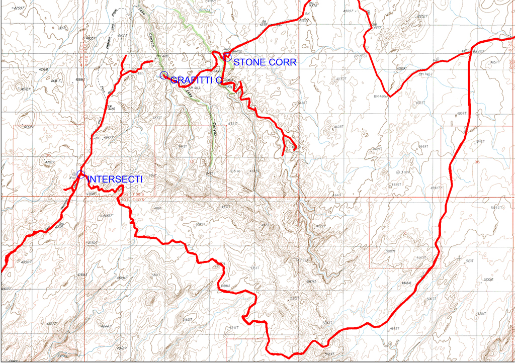
Map:
Click here to view on CalTopo
I wouldn't be able to pull this off until next year at the soonest, but I thought it'd be good to throw out the idea now and start collecting any beta I can now from any of you who are already familiar with any sections.
Some questions I have to start off with:
1. PACKRAFTING: How feasible would packrafting across Lake Powell, from the actual Hole in the Rock across to Cottonwood be? How much time could be expected having to paddle a distance of 2-3 miles across flat water like that? Any kind of current coming through there that could pull a packraft off course? Anybody have experience with a Klymit LiteWater Dingy? Even if I could afford an Alpalcka, I'm sure I'd much rather have the lighter weight LWD in my pack, or maybe an Alpalcka Ghost?
2. WATER: Are there any other good water sources besides the springs, streams, and potholes/washes I've scoured google satellite and marked up on the map below? Are any of the ones I have marked less reliable? How is Green Water Spring or Irish Water Spring near the Castle ruins? What about Red House Spring or Collins Spring off either side of Highway 276 coming out of Clay Hills? Would Spring be a better season than Fall for increased potential water sources such snowmelt running off from higher elevations? I already expect I'll have to carry a full day's worth of water between camps for many of the days.
3. HAZARDS: Any other hazards to be aware of besides the usual flashfloods, weather, and such? I'm thinking this is a route I'd only want to attempt when I have a 7-10 day forecast of fair to good weather forecasted for the area. It should go without saying that I'd want to do this in Spring or Fall when temperatures should be more ideal.
Based on the route I've laid out below, the itinerary would look something like this:
Pre-Hike: Camp near Dance Hall Rock
Day 1: Dance Hall Rock to Hole-In-the-Rock Spring, ~15 miles
Day 2: HIR Spring to Cottonwood Canyon, ~8.5 (including packraft across Powell)
Day 3: Cottonwood Canyon to Lake Canyon, ~20 miles
Day 4: Lake Canyon to Castle Creek/Green Water Spring, ~16 miles
Day 5: Castle Creek/Green Water Spring to Dripping Canyon, ~19 miles
Day 6: Dripping Canyon to Kane Gulch, ~18 miles
Day 7: Kane Gulch to Snow Flat (The Twist), ~17 miles
Day 8: Snow Flat (The Twist) to Butler Wash, ~20 miles
Day 9 : Butler Wash to Bluff, ~6 miles
Post-hike: Lunch in Bluff, stay a night and/or get picked up and go home.
Map:
Click here to view on CalTopo


")
") I'd like to do it with a backpack. I would be cool to re-read the book The Undanunted while on the trip.
I'd like to do it with a backpack. I would be cool to re-read the book The Undanunted while on the trip.