Backpacking Canyonlands The Maze, April 2025

Mikjik86

Member
Joined
Apr 22, 2018
Messages
91
Hey there Friends check out my newest Backpacking video! You can find all my other Hiking/Backpacking/Camping content on my Youtube channel TheWayOutdoors
This is a 4 day backpacking trip in the Maze District of Canyonlands National Park. Sunday April, 13th 2025 we drove out to Hanksville, Utah where we met up with Jake and grabbed Burgers from Stan's Burger Shack, loaded up the gear and headed towards the Maze. Night 1 we car camped near the Hans Flat Ranger Station where we would be getting our permits the next morning.
This is a reverse route of the hike I did back in 2017. You can find that video here.
https://youtu.be/1Sn-dEjwE_I?si=wjxUHT2q9KIm0bms

That trip was filmed with a GoPro and was some of my earlier content.
Day 1 we picked up our permits at the Hans Flat Ranger station and headed toward the Maze Overlook where we would start backpacking. The drive from the Highway to the Maze Overlook will take anywhere between 3-5 hours with the second half being on high clearance 4x4 short wheel base only. We headed down the Flint Switchbacks dropping down a couple thousand feet as we got closer to the Maze Overlook. The drive is long and bumpy, with a few sections where having someone spot the vehicle is ideal. Once at the Maze Overlook we loaded up gear, ate our delicious sandwiches and dropped down into The Maze. We hiked roughly 5-6 miles and found camp on a sandy beach along the dry creek bed.

Day 2 we woke up ready for a big day. This would prove to be just that. The plan for Day 2 was to hike out of the main canyon system and head South and up onto the land of standing rocks. From there we headed South to The Dollhouse then Northeast to the mouth of Water Canyon for night 2. This day ended up being nearly 20 miles with dozens of ups and downs climbing in and out of canyons. A huge backpacking day for sure, and one of the longest in recent memory. We camped at a beautiful spot overlooking the pour off pool in Water Canyon.

Day 3 we enjoyed a beautiful morning in Water Canyon and hit the trail. This day took us through Shot Canyon back up top near the standing rocks and back into the main canyon system where we passed The Harvest Scene. This is an excellent Pictograph panel with multiple scenes. This as another strenuous and windy hike, yet we made it to camp just under the Overlook where wed be hiking out the next morning at around 3:30 PM. We had plenty of time to relax and unwind at camp on our last day.

Day 4 we packed up early, made the big climb out of the Maze and headed back to Hanksville. The drive out was more manageable with us being more familiar with the route, and we also aired down the tires significantly. We stopped by Stan's Burgers one more time on the way out and headed home.
The Maze district of Canyonlands is extremely remote, and getting there requires a long 4x4 drive, or a Jet Boat drop-off near the Southeast corner of The maze at the Dollhouse. Water is extremely difficult to find with us having to rely on seasonal springs and potholes that dry up quickly once the weather heats up. April was a perfect time for us to go with temperatures in the high 70's and low 80's and it being nice and cool in the evenings. The miles were roughly 20-30% more than I anticipated and very rough on the feet. We hiked roughly 38 miles with close to 4.5k of elevation gain.

I hadn't expected to return to The Maze with it being so remote and a huge undertaking yet this trip was unbelievable. I spent dozens of hours editing, and hope you enjoy the added media clips and narration.

Safe Trails!
 
Nice! Question for you: At 20:40 in your video, you guys are climbing down a rock feature. Right before you got to that spot, did you get there from the left (as seen from below, as in the video)? That's what it looks like in the video. Last year I attempted a climb of the Maze Overlook (starting from below) and when I got to that spot in your video, I carefully climbed up it but then I couldn't tell if the route was to the left or to the right. To the left looked very sketchy to me and I didn't see any cairns or clear route to the right either so we turned back (we were short on time though). At least I think it was that spot! Do you happen to have any video or photos of the little section right before that point in the video? (I have a future trip in mind that would attempt that route again).
 
Last edited:
Thanks for the report, I'll watch the video when I get home tonight. My son and I are taking the boat to Spanish Bottom in the fall and backpacking in, staying two nights. Main goal is to see the famous panel and the granaries. We'll likely have a bit of extra time to kill. Anything else in that general area that you would label "can't miss".
 
Thanks for the report, I'll watch the video when I get home tonight. My son and I are taking the boat to Spanish Bottom in the fall and backpacking in, staying two nights. Main goal is to see the famous panel and the granaries. We'll likely have a bit of extra time to kill. Anything else in that general area that you would label "can't miss".
Jasper Ridge. Two nights is really pushing it though (three would be much better)
 
Jasper Ridge. Two nights is really pushing it though (three would be much better)
Wow, some really cool vistas from up there. I'll have to do a deeper dive to find routes/water sources/etc. We're comfortable with higher mileage, but after a bad experience I'm hesitant to take on anything too sketchy.
 
Wow, some really cool vistas from up there. I'll have to do a deeper dive to find routes/water sources/etc. We're comfortable with higher mileage, but after a bad experience I'm hesitant to take on anything too sketchy.
There are no water sources up on the ridge, but it doesn't really add any length or difficulty to your trip at all (if you look at any map you'll see an official trail there; it's no harder than any of the other trails in the Maze). I was merely saying that 2 nights is tough regardless of your route specifics if you want to visit the panel, since you need to get back to catch the boat ride on the way out pretty early the last day (unless they run later these days).

Another tip: you'll want to visit the panel in the morning, before the sun hits it. Both times I've been there were in the morning and both times when the sun came up over the canyon walls the panel instantly became much harder to see (almost invisible compared to a few minutes earlier!). The evening is likely good as well. Maybe on an overcast day it doesn't really make a difference.
Thanks so much for the tip on seeing the panel early. A lot of the photos I see of it look faded out, and that's probably the reason. I've looked at several maps online and have found nothing that mentions Jasper Ridge, but I finally ran across one that shows Jasper Canyon. With that info and after reading thru and trying to decipher a couple trip reports I think I've determined that Jasper Ridge is the easternmost part of the trail loop that goes to the panel (called Pete's Mesa trail on my map). Is that correct? That was my planned route anyways and it seemed manageable, even with the early boat pickup (10am). Again, thanks for your assistance, really appreciate the shared wisdom.
 
The trail down toward Pete's Mesa is very nice. The Harvest scene is amazing, and being there in the morning is definitely the way to go. 2 nights is just barely enough time to get a taste of the Maze.

Always wanted to take a shot at climbing the Maze Overlook trail, but I'm not sure when I'll ever get back down to the Maze.
Thanks for the info and confirmation. I didn't do my first backpacking trip until I was 60 and I've never done more than 2 days. I started on a longer one a couple years ago and had a random accident that resulted in an airlift out, so confidence suffered a bit. With all the trouble it takes to get out to the Maze I am regretting not spending more time out there though.
 
Thanks so much for the tip on seeing the panel early. A lot of the photos I see of it look faded out, and that's probably the reason. I've looked at several maps online and have found nothing that mentions Jasper Ridge, but I finally ran across one that shows Jasper Canyon. With that info and after reading thru and trying to decipher a couple trip reports I think I've determined that Jasper Ridge is the easternmost part of the trail loop that goes to the panel (called Pete's Mesa trail on my map). Is that correct? That was my planned route anyways and it seemed manageable, even with the early boat pickup (10am). Again, thanks for your assistance, really appreciate the shared wisdom.

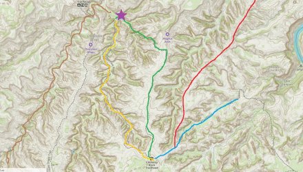
Yes, the trail/canyon names in the The Maze are a bit confusing. Just for clarity, the Jasper Ridge route is an 'unofficial' trail (red line on the map below) that heads NNE from close to the junction of Shot Canyon trail (blue line) and the Chimney Rock Trailhead.

I agree with @RyanP and @b.stark that the Pete's Mesa trail (green line) is a highlight. In fact, this would make a great spot to camp on Day #1 of your trip, since it has magnificent panoramic views across the entire area, especially at sunset. From there, you'd be able to reach the Harvest Panel early the next day, and get some water from the spring close by (purple star on the map).

From there, it's only 4 miles back to Chimney Rock via Pictograph Fork (orange line), or if you have decided to do Day #2 as a day-hike from camp, then it's 13 miles via South Fork Horse Canyon (brown line). South Fork is probably my favourite in The Maze, since there is occasional ground water, and therefore some pretty vegetation along the way.

A bonus of the South Fork return route is that, after exiting the canyon, you'll then be hiking past some outstanding sandstone features, such as The Wall, Lizard Rock, and The Plug.

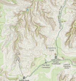
Even if you don't take this route in its entirety, then it'd be worth hiking the first quarter-mile south, in order to get some of the best views of The Chocolate Drops. And, you might even want to clamber up to the Maze Overlook, for some magnificent views. It's about a 1.5 - 2 hour return trip from the canyon floor.
.
.

Maze Routes Jun 2025 v1.jpg
 
Last edited:
I think that's referring to the mesa itself, and not the ridge that the trail goes along (correct me if I'm wrong!)

Yes, from the park map, it looks as though it's ok to camp along most of the Pete's Mesa trail, but as @IntrepidXJ says, it's not allowed on the mesa itself.

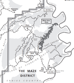
It's interesting to note just how extensive the exclusion zone for backpacking camping actually is in The Maze. On the map below, it's only officially permitted in the light grey areas. This, of course, makes an early start to catch the returning jet-boat essential. (p.s. the ugly dark grey blob on the map is Jasper Canyon, which is out of bounds to all travel)

As an aside, National Parks commonly have some restrictions on backcountry camping in locations close to water sources, or archaeological sites, or trailheads, or vehicle camps etc, which are all understandable, but I'm not sure I see why they often don't allow camping next to remote jeep roads, such as those in the heart of The Maze.
.
.

Maze Camping JUne 2025 v1.png
 
Last edited:
Yes, the trail/canyon names in the The Maze are a bit confusing. Just for clarity, the Jasper Ridge route is an 'unofficial' trail (red line on the map below) that heads NNE from close to the junction of Shot Canyon trail (blue line) and the Chimney Rock Trailhead.

I agree with @RyanP and @b.stark that the Pete's Mesa trail (green line) is a highlight. In fact, this would make a great spot to camp on Day #1 of your trip, since it has magnificent panoramic views across the entire area, especially at sunset. From there, you'd be able to reach the Harvest Panel early the next day, and get some water from the spring close by (purple star on the map).

From there, it's only 4 miles back to Chimney Rock via Pictograph Fork (orange line), or if you have decided to do Day #2 as a day-hike from camp, then it's 13 miles via South Fork Horse Canyon (brown line). South Fork is probably my favourite in The Maze, since there is occasional ground water, and therefore some pretty vegetation along the way.

A bonus of the South Fork return route is that, after exiting the canyon, you'll then be hiking past some outstanding sandstone features, such as The Wall, Lizard Rock, and The Plug.

Even if you don't take this route in its entirety, then it'd be worth hiking the first quarter-mile south, in order to get some of the best views of The Chocolate Drops. And, you might even want to clamber up to the Maze Overlook, for some magnificent views. It's about a 1.5 - 2 hour return trip from the canyon floor.
.
.

View attachment 142053
Thanks so much for the map and the detailed info...very helpful and clears up a couple things I was unsure of. I was intrigued by adding the Maze overlook to our trip, but was not sure how sketchy and how long that would take...I'll have to do a bit more research. I love the suggestion of returning via South Fork...most of that trail shows on my map as unmaintained so wasn't sure how long it would take to navigate thru there. We're fast hikers when the way is clear, but need to be sure we can get to a spot on night 2 that will allow us to catch our boat ride the next morning.
 
Nice! Question for you: At 20:40 in your video, you guys are climbing down a rock feature. Right before you got to that spot, did you get there from the left (as seen from below, as in the video)? That's what it looks like in the video. Last year I attempted a climb of the Maze Overlook (starting from below) and when I got to that spot in your video, I carefully climbed up it but then I couldn't tell if the route was to the left or to the right. To the left looked very sketchy to me and I didn't see any cairns or clear route to the right either so we turned back (we were short on time though). At least I think it was that spot! Do you happen to have any video or photos of the little section right before that point in the video? (I have a future trip in mind that would attempt that route again).
Hey Ryan, from the shot at 20:40 you climb that wall then walk left (South) along an exposed shelf to a dry pour that has a small opening you climb through. You can see that spot at 1:32:15. Check out my footage of the climb out as it might show more of what you are looking for. I appreciate you checking out the video!
 
Thanks so much for the map and the detailed info...very helpful and clears up a couple things I was unsure of. I was intrigued by adding the Maze overlook to our trip, but was not sure how sketchy and how long that would take...I'll have to do a bit more research. I love the suggestion of returning via South Fork...most of that trail shows on my map as unmaintained so wasn't sure how long it would take to navigate thru there. We're fast hikers when the way is clear, but need to be sure we can get to a spot on night 2 that will allow us to catch our boat ride the next morning.
South Fork is relatively fast traveling. The climb out of South Fork heading up to the Land of Standing Rocks is pretty long and winds around much more than my outdated Nat Geo map showed. South Fork of Horse Canyon is beautiful and plentiful with water for the most part, especially with potholes. 2 days would be pushing it, but get creative with your route, and wake up early to crush those miles as needed. The above recommendations are excellent information as well. One other note is that our mileage ended up being roughly 25%-35% more than what we anticipated while map planning. Safe Trails!
 
Hey Ryan, from the shot at 20:40 you climb that wall then walk left (South) along an exposed shelf to a dry pour that has a small opening you climb through. You can see that spot at 1:32:15. Check out my footage of the climb out as it might show more of what you are looking for. I appreciate you checking out the video!
Thanks! Somehow it didn't occur to me to check later in the video for the climb on the way back out... yup, that answers my question. The initial/obvious route to the left was indeed the correct route. Looked more sketchy in person than in your video! (I'm not a climber at all though and we were kind of rushed on time)
 

Don't like ads? Become a BCP Supporting Member and kiss them all goodbye. Click here for more info.

Back
Top