Mikjik86
Member
- Joined
- Apr 22, 2018
- Messages
- 93
This is a 4 day backpacking trip in the Maze District of Canyonlands National Park. Sunday April, 13th 2025 we drove out to Hanksville, Utah where we met up with Jake and grabbed Burgers from Stan's Burger Shack, loaded up the gear and headed towards the Maze. Night 1 we car camped near the Hans Flat Ranger Station where we would be getting our permits the next morning.
This is a reverse route of the hike I did back in 2017. You can find that video here.
https://youtu.be/1Sn-dEjwE_I?si=wjxUHT2q9KIm0bms
That trip was filmed with a GoPro and was some of my earlier content.
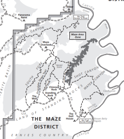
Day 1 we picked up our permits at the Hans Flat Ranger station and headed toward the Maze Overlook where we would start backpacking. The drive from the Highway to the Maze Overlook will take anywhere between 3-5 hours with the second half being on high clearance 4x4 short wheel base only. We headed down the Flint Switchbacks dropping down a couple thousand feet as we got closer to the Maze Overlook. The drive is long and bumpy, with a few sections where having someone spot the vehicle is ideal. Once at the Maze Overlook we loaded up gear, ate our delicious sandwiches and dropped down into The Maze. We hiked roughly 5-6 miles and found camp on a sandy beach along the dry creek bed.
Day 2 we woke up ready for a big day. This would prove to be just that. The plan for Day 2 was to hike out of the main canyon system and head South and up onto the land of standing rocks. From there we headed South to The Dollhouse then Northeast to the mouth of Water Canyon for night 2. This day ended up being nearly 20 miles with dozens of ups and downs climbing in and out of canyons. A huge backpacking day for sure, and one of the longest in recent memory. We camped at a beautiful spot overlooking the pour off pool in Water Canyon.
Day 3 we enjoyed a beautiful morning in Water Canyon and hit the trail. This day took us through Shot Canyon back up top near the standing rocks and back into the main canyon system where we passed The Harvest Scene. This is an excellent Pictograph panel with multiple scenes. This as another strenuous and windy hike, yet we made it to camp just under the Overlook where wed be hiking out the next morning at around 3:30 PM. We had plenty of time to relax and unwind at camp on our last day.
Day 4 we packed up early, made the big climb out of the Maze and headed back to Hanksville. The drive out was more manageable with us being more familiar with the route, and we also aired down the tires significantly. We stopped by Stan's Burgers one more time on the way out and headed home.
The Maze district of Canyonlands is extremely remote, and getting there requires a long 4x4 drive, or a Jet Boat drop-off near the Southeast corner of The maze at the Dollhouse. Water is extremely difficult to find with us having to rely on seasonal springs and potholes that dry up quickly once the weather heats up. April was a perfect time for us to go with temperatures in the high 70's and low 80's and it being nice and cool in the evenings. The miles were roughly 20-30% more than I anticipated and very rough on the feet. We hiked roughly 38 miles with close to 4.5k of elevation gain.
I hadn't expected to return to The Maze with it being so remote and a huge undertaking yet this trip was unbelievable. I spent dozens of hours editing, and hope you enjoy the added media clips and narration.
Safe Trails!


