Vegan.Hiker
Member
- Joined
- Jul 5, 2014
- Messages
- 2,099
Assateague Island National Seashore
February 27th - March 1st, 2015
Rather than head north into the Catskills, Whites, or Adirondacks for another winter hike in the mountains, I decided to try something a little different for my next trip. So this past weekend, I headed 4.5 hours south to Maryland to backpack two nights on Assateague Island.
For those of you that aren't familiar with Assateague Island, it is a 37 mile long barrier island off the coast of Maryland and Virginia. Although it's 37 miles long, it never reaches more than a mile wide. The island is divided into 3 parts, Assateague Island National Seashore and Assateague State Park on the Maryland side, and the Chincoteague National Wildlife Refuge on the Virginia side. The island is well known for it's wild horses that inhabit the island. The NPS took over the island after a nor'easter destroyed ensuing plans to build a 5,000 unit resort community in 1962. Building structures on the island was deemed too dangerous.
The island has wide sandy beaches on the eastern edge facing the Atlantic ocean. The western side facing the mainland is predominantly salt marshes, maritime forests, and coastal bays.
Here is a google maps image so you can see the general shape of the island.

A 12 mile stretch of the National Park is set aside for backcountry use. You can hike in, or kayak in on the bay side. Part of the area allows for OSV's (Over Sand Vehicles) to travel into parts of the backcountry along the top edge of the beach. Fortunately, I didn't see any while I was there.
Below is a map showing the backcountry campsites and paddling routes. There is no trail system, backpackers just hike along the beach for the most part. When crossing over to the bay side it is easier to find an OSV path to ensure you stay on solid ground and don't end up in a marsh. My original plan was to hike the 12 miles one way to the State Line campsite, set up camp, and spend the weekend hiking around exploring the island. However, I realized last minute that you cannot get a backcountry permit ahead of time, you need to get it in-person at the Ranger Station. Since I couldn't make it to the station on Friday before they closed (4 pm), I had to change my plans. I camped on the beach my first night not far from the Ranger Station. In the morning I went to the Ranger Station to get my backcountry permit and headed out. Since I lost time not being able to head out Friday evening, I decided to set up camp Saturday night at the closer Little Levels campsite, then would hike around and explore the island for the rest of the day.

Packing for a trip like this was very different than for most hikes. My pack was already heavy from packing in firewood and 2 days of water, so the idea of going light was out the window. Despite it's weight and that it's several holes, I took an old tent that is the only fully free-standing tent I own. I knew that there could be some ocean winds to contend with and staking in sand is a crapshoot. So going with a fully freestanding tent felt like the way to go. I was tempted to try out my new Terra Nova UL tent but I figured that getting sand in the seams before seam sealing it would be a bad idea.
Where I camped Friday night. It was very relaxing to fall asleep to the sound of the crashing waves.

The beach consisted of patches of sand and snow.
One good thing about this turn of events was that my car wasn't too far of a walk the first night and I had a trunk load of firewood and yeungling! Even though the forecast for the island was for lows of around 17 degrees, being directly on the shore, the temps fell below zero both nights..


Eager to head out, I got up early to get my permit. I was also able to catch part of the sunrise Saturday morning. However, it was not nearly as beautiful as the sunrise I would be treated to on Sunday.
This horseshoe crab apparently succumbed to the winter.
Finally got my permit when the office opened up.

@ben cowan asked me in another thread whether National Parks saw overpopulation on the east coast. As I was leaving to enter the backcountry, my car was the only one in the parking lot. The possibility of having over 41,000 acres of coastal backcountry all to myself boggled my mind... on a weekend no less. Turned out to be true. My car was still the only one there when I returned on Sunday and I didn't see another person or OSV the whole time I was out there.
I headed out along the beach... elevation: sea level, elevation gain: 0'. In the warmer months walking on soft sand would be pretty tiring. In the winter the sand freezes pretty solid so it was extremely easy going. Not to mention no elevation gain/loss and no need to ever look at a map or compass... If the ocean is on your left you are heading south, on your right and your heading north.

And we have a winter survivor.

After a few miles I saw a stretch of woods close by, on the inner part of the island. I decided to hike through the woods for a while. I thought this tree was pretty cool.

As I was hiking I entered a small clearing and encountered a family of five wild horses. They were about 30 feet away when I stumbled upon them. They were the size of full-sized horses, but had the look and shape of ponies... giant ponies. Only one paid any attention to me and stared a lot. I assume he was the stallion feeling protective of it's mares. One strange thing that I saw happen was one laying on the ground about 30 feet from me and rolling over, I assume to scratch his back? He/she then stood up and shook itself clean. I've witnessed my dog do this before, but it was strange seeing a wild horse do it. I was lucky to have gotten this on video. The clip is in my video at the end of the report.

This was the one that was grilling me. I thought it was Sebastian Bach for a moment.. but wait, Skid Row broke up years ago didn't they? Turns out, it was a wild horse.

It just stared at me for several minutes.
After a while, he began to eat and ignore me like the others.

I know you guys out west probably see wild horses pretty often but this was a first for me. I must say they are majestic, beautiful creatures. I didn't want to disturb them so I left them after snapping a few pics and videos. Btw - if you're wondering how these horses got here, the most common theory is that they are survivors from an offshore shipwreck that occurred in the 1600's.

I headed back to the beach and finally came across the sign for the Little Levels campsite. Well, besides the sign there wasn't anything. No assigned sites, no picnic tables, fire rings, etc. So I walked around the dunes looking for a good, somewhat sheltered spot to pitch camp. I came across this sunken-in spot between two dunes. While the wind was pretty calm the whole weekend, the breeze off the ocean is extremely cold. This spot sheltered me from the ocean breeze keeping me a little warmer.
Again the ground was frozen and it was impossible to get the stakes in the ground. I thought of something this time though. I boiled some water and poured it on the sand where I wanted to stake. I'm sure I'm not the first person to ever think of this and I felt dumb for not thinking of it the night before when I broke 3 stakes.

After pitching the tent, I ate lunch before heading out to explore for the day. What does a vegan hiker eat for lunch you ask? An avocado, an opal apple, some walnuts (already in my tummy) and a yeungling made for an almost-healthy lunch.
After lunch, I decided to explore the bay side of the island and check out the Pine Tree campsite which is on a forested peninsula. The bay side is a mix of salt marshes like this and maritime forests.

Walking on the bay side, bands of wild horses can be seen all around grazing in the salt marshes. They were all pretty far out in the distance this time. I didn't encounter any close-up except for that one time earlier in the day.
I found a path that led to the Pine Tree campsite. Apparently the horses like this path.

The Pine Tree peninsula was peaceful and serene.
As soon as I saw the Pine Tree campsite, complete with picnic tables and spare firewood I regretted not camping here. Would have been nice to camp one night on the beach and one night on the bay.
Since the bay is on the west, the sun was setting on that side.
As you can see below, the bay was frozen.

I started walking back after sunset and took a nice night time walk on the beach. It was a clear night and the moon kept the beach lit pretty well. I eventually found my way back to camp (would have never found it had I not dropped a waypoint in my GPS) and had dinner. Before going to bed, I leaned back against the dunes and stared at the sky while listening to the sound of the waves crashing. I really wasn't expecting to enjoy this trip as much as I did.
So what does a vegan hiker eat for dinner? Had some Good to Go, Herbed Mushroom Risotto. I felt fancy.

Looking out from near my camp before sunrise Sunday morning.

I took a morning walk on the beach before going back to pack up my stuff. Clouds were rolling in and there was a 70% chance of snow starting around noon so I played it safe and headed back early. Part of me wanted to experience hiking on the beach during snowfall though.
One last shot of my campsite Sunday morning.
After I packed up and headed out to the beach for the hike back, the sky was constantly changing. I almost felt guilty for having all of this to myself.
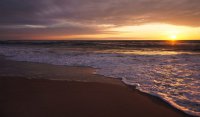
The sun starting to rise over the horizon.


Walking back along the beach, I found myself deliberately walking slow as I didn't want to get back to my car too quick. Being a mountain guy, I never realized how glorious this type of backpacking could be. It made me a little upset that my trip to backpack the Lost Coast Trail in CA was derailed by a change of plans. I want to do that trip even more now.


As more clouds rolled in the sky kept changing.
The "trail" back.


For some reason, I think this picture is my favorite.


Hiking out, I noticed something had washed ashore. It definitely wasn't there when I hiked in and it was still saturated. It looks to have been part of a dock or something. I wondered where it came from and where it would eventually end up after high tide washed it back out to sea.


I was actually a little bummed when I arrived at my vehicle. I kind of wanted to hike more. This rarely happens to me, probably because most hikes are much more strenuous and there's usually a sense of relief arriving back at the trailhead. I took a lot more pictures than usual because it was one of those easy, relaxing hikes where I had time to just putz around and play with the camera a lot.
As if this trip report wasn't already way too long, I made a little video with some of the video footage I took. It'll look much better if you watch it in 1080p.
February 27th - March 1st, 2015
Rather than head north into the Catskills, Whites, or Adirondacks for another winter hike in the mountains, I decided to try something a little different for my next trip. So this past weekend, I headed 4.5 hours south to Maryland to backpack two nights on Assateague Island.
For those of you that aren't familiar with Assateague Island, it is a 37 mile long barrier island off the coast of Maryland and Virginia. Although it's 37 miles long, it never reaches more than a mile wide. The island is divided into 3 parts, Assateague Island National Seashore and Assateague State Park on the Maryland side, and the Chincoteague National Wildlife Refuge on the Virginia side. The island is well known for it's wild horses that inhabit the island. The NPS took over the island after a nor'easter destroyed ensuing plans to build a 5,000 unit resort community in 1962. Building structures on the island was deemed too dangerous.
The island has wide sandy beaches on the eastern edge facing the Atlantic ocean. The western side facing the mainland is predominantly salt marshes, maritime forests, and coastal bays.
Here is a google maps image so you can see the general shape of the island.
A 12 mile stretch of the National Park is set aside for backcountry use. You can hike in, or kayak in on the bay side. Part of the area allows for OSV's (Over Sand Vehicles) to travel into parts of the backcountry along the top edge of the beach. Fortunately, I didn't see any while I was there.
Below is a map showing the backcountry campsites and paddling routes. There is no trail system, backpackers just hike along the beach for the most part. When crossing over to the bay side it is easier to find an OSV path to ensure you stay on solid ground and don't end up in a marsh. My original plan was to hike the 12 miles one way to the State Line campsite, set up camp, and spend the weekend hiking around exploring the island. However, I realized last minute that you cannot get a backcountry permit ahead of time, you need to get it in-person at the Ranger Station. Since I couldn't make it to the station on Friday before they closed (4 pm), I had to change my plans. I camped on the beach my first night not far from the Ranger Station. In the morning I went to the Ranger Station to get my backcountry permit and headed out. Since I lost time not being able to head out Friday evening, I decided to set up camp Saturday night at the closer Little Levels campsite, then would hike around and explore the island for the rest of the day.
Packing for a trip like this was very different than for most hikes. My pack was already heavy from packing in firewood and 2 days of water, so the idea of going light was out the window. Despite it's weight and that it's several holes, I took an old tent that is the only fully free-standing tent I own. I knew that there could be some ocean winds to contend with and staking in sand is a crapshoot. So going with a fully freestanding tent felt like the way to go. I was tempted to try out my new Terra Nova UL tent but I figured that getting sand in the seams before seam sealing it would be a bad idea.
Where I camped Friday night. It was very relaxing to fall asleep to the sound of the crashing waves.
The beach consisted of patches of sand and snow.
One good thing about this turn of events was that my car wasn't too far of a walk the first night and I had a trunk load of firewood and yeungling! Even though the forecast for the island was for lows of around 17 degrees, being directly on the shore, the temps fell below zero both nights..
Eager to head out, I got up early to get my permit. I was also able to catch part of the sunrise Saturday morning. However, it was not nearly as beautiful as the sunrise I would be treated to on Sunday.
This horseshoe crab apparently succumbed to the winter.
Finally got my permit when the office opened up.
@ben cowan asked me in another thread whether National Parks saw overpopulation on the east coast. As I was leaving to enter the backcountry, my car was the only one in the parking lot. The possibility of having over 41,000 acres of coastal backcountry all to myself boggled my mind... on a weekend no less. Turned out to be true. My car was still the only one there when I returned on Sunday and I didn't see another person or OSV the whole time I was out there.
I headed out along the beach... elevation: sea level, elevation gain: 0'. In the warmer months walking on soft sand would be pretty tiring. In the winter the sand freezes pretty solid so it was extremely easy going. Not to mention no elevation gain/loss and no need to ever look at a map or compass... If the ocean is on your left you are heading south, on your right and your heading north.
And we have a winter survivor.
After a few miles I saw a stretch of woods close by, on the inner part of the island. I decided to hike through the woods for a while. I thought this tree was pretty cool.
As I was hiking I entered a small clearing and encountered a family of five wild horses. They were about 30 feet away when I stumbled upon them. They were the size of full-sized horses, but had the look and shape of ponies... giant ponies. Only one paid any attention to me and stared a lot. I assume he was the stallion feeling protective of it's mares. One strange thing that I saw happen was one laying on the ground about 30 feet from me and rolling over, I assume to scratch his back? He/she then stood up and shook itself clean. I've witnessed my dog do this before, but it was strange seeing a wild horse do it. I was lucky to have gotten this on video. The clip is in my video at the end of the report.
This was the one that was grilling me. I thought it was Sebastian Bach for a moment.. but wait, Skid Row broke up years ago didn't they? Turns out, it was a wild horse.
It just stared at me for several minutes.
After a while, he began to eat and ignore me like the others.
I know you guys out west probably see wild horses pretty often but this was a first for me. I must say they are majestic, beautiful creatures. I didn't want to disturb them so I left them after snapping a few pics and videos. Btw - if you're wondering how these horses got here, the most common theory is that they are survivors from an offshore shipwreck that occurred in the 1600's.
I headed back to the beach and finally came across the sign for the Little Levels campsite. Well, besides the sign there wasn't anything. No assigned sites, no picnic tables, fire rings, etc. So I walked around the dunes looking for a good, somewhat sheltered spot to pitch camp. I came across this sunken-in spot between two dunes. While the wind was pretty calm the whole weekend, the breeze off the ocean is extremely cold. This spot sheltered me from the ocean breeze keeping me a little warmer.
Again the ground was frozen and it was impossible to get the stakes in the ground. I thought of something this time though. I boiled some water and poured it on the sand where I wanted to stake. I'm sure I'm not the first person to ever think of this and I felt dumb for not thinking of it the night before when I broke 3 stakes.
After pitching the tent, I ate lunch before heading out to explore for the day. What does a vegan hiker eat for lunch you ask? An avocado, an opal apple, some walnuts (already in my tummy) and a yeungling made for an almost-healthy lunch.
After lunch, I decided to explore the bay side of the island and check out the Pine Tree campsite which is on a forested peninsula. The bay side is a mix of salt marshes like this and maritime forests.
Walking on the bay side, bands of wild horses can be seen all around grazing in the salt marshes. They were all pretty far out in the distance this time. I didn't encounter any close-up except for that one time earlier in the day.
I found a path that led to the Pine Tree campsite. Apparently the horses like this path.
The Pine Tree peninsula was peaceful and serene.
As soon as I saw the Pine Tree campsite, complete with picnic tables and spare firewood I regretted not camping here. Would have been nice to camp one night on the beach and one night on the bay.
Since the bay is on the west, the sun was setting on that side.
As you can see below, the bay was frozen.
I started walking back after sunset and took a nice night time walk on the beach. It was a clear night and the moon kept the beach lit pretty well. I eventually found my way back to camp (would have never found it had I not dropped a waypoint in my GPS) and had dinner. Before going to bed, I leaned back against the dunes and stared at the sky while listening to the sound of the waves crashing. I really wasn't expecting to enjoy this trip as much as I did.
So what does a vegan hiker eat for dinner? Had some Good to Go, Herbed Mushroom Risotto. I felt fancy.
Looking out from near my camp before sunrise Sunday morning.
I took a morning walk on the beach before going back to pack up my stuff. Clouds were rolling in and there was a 70% chance of snow starting around noon so I played it safe and headed back early. Part of me wanted to experience hiking on the beach during snowfall though.
One last shot of my campsite Sunday morning.
After I packed up and headed out to the beach for the hike back, the sky was constantly changing. I almost felt guilty for having all of this to myself.
The sun starting to rise over the horizon.
Walking back along the beach, I found myself deliberately walking slow as I didn't want to get back to my car too quick. Being a mountain guy, I never realized how glorious this type of backpacking could be. It made me a little upset that my trip to backpack the Lost Coast Trail in CA was derailed by a change of plans. I want to do that trip even more now.
As more clouds rolled in the sky kept changing.
The "trail" back.
For some reason, I think this picture is my favorite.
Hiking out, I noticed something had washed ashore. It definitely wasn't there when I hiked in and it was still saturated. It looks to have been part of a dock or something. I wondered where it came from and where it would eventually end up after high tide washed it back out to sea.
I was actually a little bummed when I arrived at my vehicle. I kind of wanted to hike more. This rarely happens to me, probably because most hikes are much more strenuous and there's usually a sense of relief arriving back at the trailhead. I took a lot more pictures than usual because it was one of those easy, relaxing hikes where I had time to just putz around and play with the camera a lot.
As if this trip report wasn't already way too long, I made a little video with some of the video footage I took. It'll look much better if you watch it in 1080p.
Attachments
Last edited: