- Joined
- May 5, 2012
- Messages
- 1,732
The Ashdown Gorge route has been on my to-do list for a couple of years now. I'd originally hoped to complete it in the spring of 2012, during a trip to Cedar Breaks for the annular eclipse. However, a major landslide in October 2011 had wiped out a portion of Utah S.R. 14 through Cedar Canyon, rendering that idea moot.
S.R. 14 is the terminus of the point-to-point route and a necessary drop point for one shuttle vehicle. In fact, the pull-off where one parks is exactly where the landslide hit. The closure of the highway for stabilization and repair work lasted into the summer of 2012, with full access not restored until September.
Thankfully, I'd secured some pretty great tickets to see Hamlet at the Utah Shakespeare Festival on the night of October 20th and, since I was going to be in Cedar City, decided again to try and make a go of Ashdown.
I left Salt Lake City after work on Friday the 19th and didn't arrive until very late. This is partly due to my feeling drowsy and opting to pull off in Scipio for a nap. When I at last rolled to a stop in Cedar Canyon the clock had ticked past 3 a.m. A cold wind howled down the dark canyon. I set out my bed roll into the back of the wagon, put the camera on its tripod and went to bed.
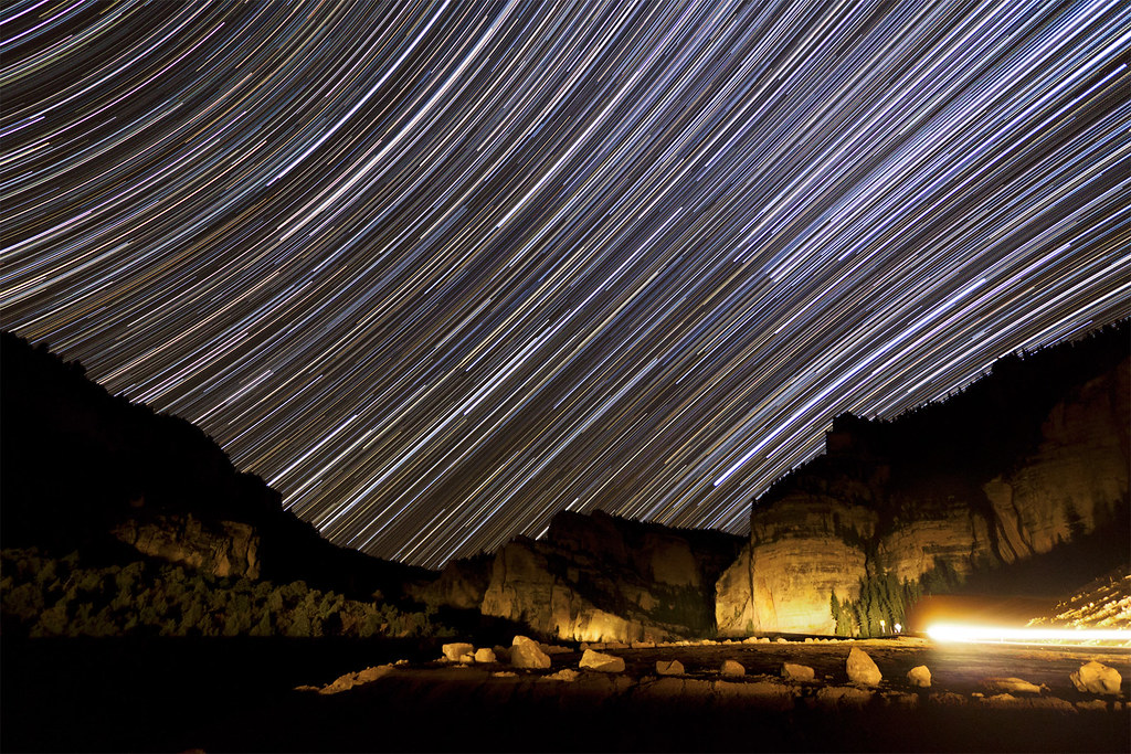
Cedar Canyon star trails by ashergrey, on Flickr
About 5:30 a.m. I roused and pulled the camera into the car. The wind still screamed. I snuggled down into my sleeping bag and drifted off again.
My phone alarm rang around 7 a.m. I ignored it. But 30 minutes later a loud knock on the window made my eyes snap open. I looked over to see my friend Jeff standing outside the car.
We'd agreed to meet at 7:30. I hastily dressed and popped out into the cold dawn. He tossed his bag into the wagon and we set out, driving the rest of the way up the canyon onto the Markagunt Plateau. The sun rising over cloudless skies made for stunning views of the Zion uplands and drainages of the upper Virgin. We didn't stop to photograph them as we should have, instead pushing to get on trail early.
Once at the Rattlesnake trailhead I scarfed down a cold breakfast of leftover pizza. A mountain biker came up the road from the direction of Brian Head as I was brushing my teeth and started asking us where the rim of Cedar Breaks was. Then he wanted to know where he could trail ride. With frothy paste dribbling down my chin I told him he was probably SOL because the wilderness boundary was only a few hundred feet away.

Scattered crusts of snow an inch or two deep ran alongside the trail as it worked toward the rim of the plateau. It was still cold even in the sunlight. We strolled along at 10,400 feet, enjoying the fragrant scent of old pine forest.
Once the trail drops over the edge of the plateau, it descends continuously until it reaches Rattlesnake Creek. Along the way you receive glimpses through the forest of the Cedar Breaks amphitheater off to the east. At Stud Flat, another exposed escarpment is revealed to the west. Most of the aspen at Stud Flat had already shed their leaves with the earlier snow. We did find a few though that still clung to autumn.
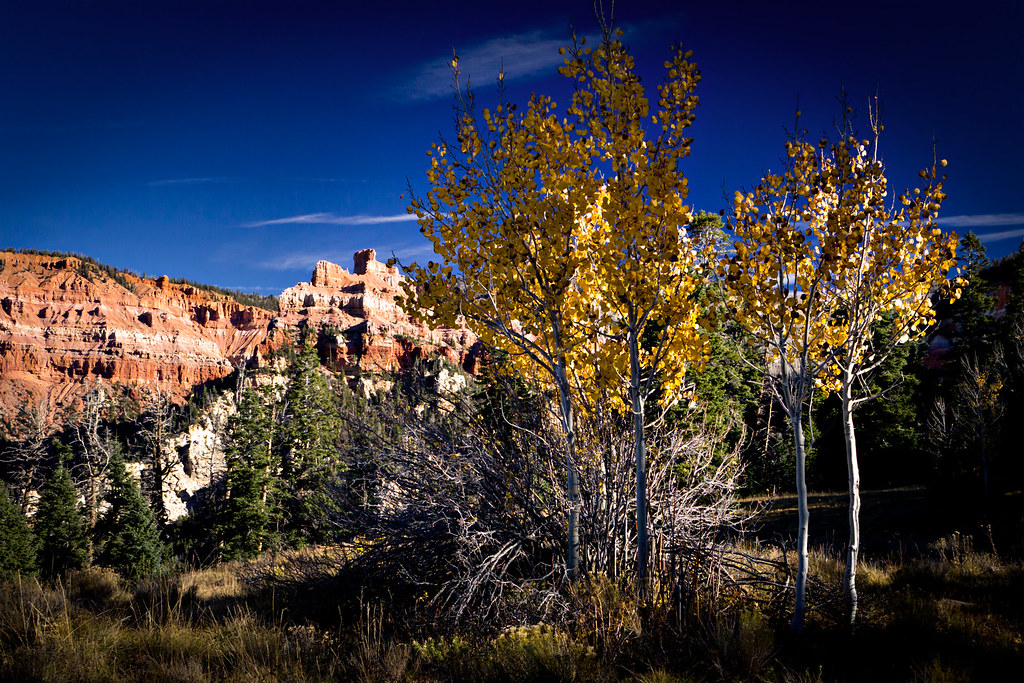
Aspens by ashergrey, on Flickr

The trail steepens as it switches its way down to the water. We followed Rattlesnake Creek along its west bank until obtaining the junction with the High Mountain Trail. This little waterfall is just feet away from the intersection.
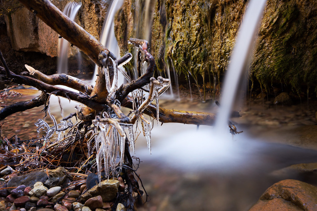
Ice by ashergrey, on Flickr
Ice. Great. We had miles of water walking coming…
Although you can't see it from the trail junction, a waterfall blocks further downstream hiking (but we'll get back to it in a bit). Instead, you have to cross over a ridge separating Rattlesnake Creek from Ashdown Creek. This is accomplished using the Potato Hollow Trail. The first hint of what's to come is revealed after cresting the ridge.

Looking east, you can see the open forest from which Ashdown Creek flows and the distant bowl of Cedar Breaks.

At the creek we donned water-suitable shoes and began splashing our way down stream. The walls immediately rise and the waterway starts to slither.

Our pace slowed as we again and again crossed, following the course around corner after corner. The brilliant blue sky and radiant beams of sunlight falling on pale-colored rock, coupled with dark shadowed nooks made for challenging photography conditions. I ended up losing the highlights on many of my shots, despite continually upping shutter speed.

The water of Ashdown Creek was turbid and milky, making it hard to gauge stream depth and foot placement. It was surprising though that when we reached the Toms Head towers and reunited with Rattlesnake Creek, the water from that tributary appeared clear.
Toms Head by ashergrey, on Flickr
It left me to wonder what the big difference is. I'm assuming it's that Ashdown originates in the very ruddy face of Cedar Breaks, while Rattlesnake Gorge rises near Brian Head, away from the red rock. In any case, the side trip up Rattlesnake Creek is well worth the time. There's a little shelf waterfall along the way that is exquisite.

A bit farther up the side canyon the walls close in… the air takes on a chill and pockets of warming sunlight become valuable resources.

Rattlesnake Creek by ashergrey, on Flickr

The waterway splits again at the junction with Lake Creek.

At this point we're not far downstream from where we crossed Rattlesnake Creek previously. It's clear here why the trail takes the circuitous path. Both Lake and Rattlesnake Creeks tumble down falls not far above their junction. We headed up Lake Creek (the western fork) first. Its waterfall is pretty but not very photogenic at low flow. The water mists out, making it all but invisible to the camera.

One spooky moment came in this spot though. There were tracks in the mud that looked very much like cougar prints. I felt grateful that we hadn't stumbled on the big cat in this dead-end canyon.
The Rattlesnake Creek waterfall is the highlight of the hike. It's narrow and obscured by the canyon walls until you're right at the foot. I was only able to shoot one photo because the heavy mist and spray soaked my camera.
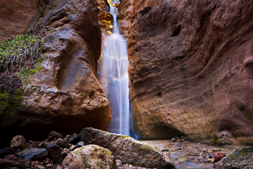
Falls on Rattlesnake Creek by ashergrey, on Flickr
Standing in this spot to take the photo left my feet numb to the point of pain. The water felt so cold it seemed to pierce my bones. The canyon is constricted enough that I'd be surprised if the floor sees more than a few minutes of sun a day.
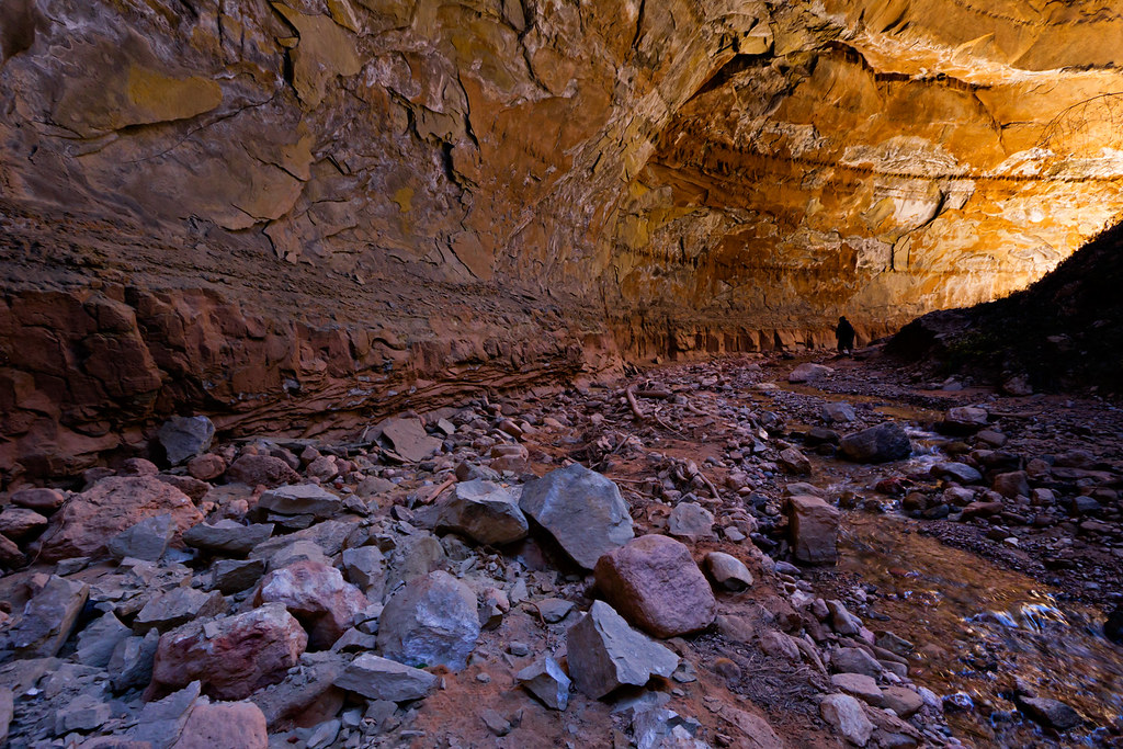
We backtracked to Ashdown Gorge and continued our walk downstream. Amazing views waited at every turn.


An interesting feature of Ashdown Gorge is its coloration. Unlike most of southern Utah's narrow spaces, it is not carved from sandstone. The walls are mostly buff-colored limestone, but in places they take on a distinct orange hue. If you look close, it becomes obvious that the brighter color is actually the result of deposits carried down from Cedar Breaks. High water flows, by which I mean flash floods, splash the sediment high up on the walls. It dries there into a sort of patina.

High flows also carry a lot — and I mean a lot — of deadfall down from the Dixie National Forest. This logjam is waiting for the right storm to turn it into a devastating debris flow. Good luck to whomever is downstream when that happens.

Even low flows have their quirks. I found this little pit of quicksand by stepping in a one-inch deep puddle. My feet sunk down until they hit a submerged rock. The mud wanted to keep my water sandals.

Instead of staring at my feet though, I tried to keep my eyes up for Flannigan Arch while working through the deepest portion of the gorge. It would be easy to miss if you weren't on the lookout. It sits high on the east wall. I've read it can be spanned, but that involves picking a path up the steep slope. We had neither the time nor inclination for that side jaunt.

The canyon floor gradually widens beyond the Arch and the views reminded me of sections of Capitol Reef. If fact, the whole experience of Ashdown Gorge is really akin to Sulphur Creek in Capitol Reef… just with trees.

Once the gorge opens, deciduous trees join with the pines. Here we saw the only other group in the canyon that day. Two guys and a gal with a dog came up from behind and passed us as I futzed with a circular polarizer.


The worst part of the trip came at the end. In the past, the hike would have continued down Coal Creek a short distance to a dirt road. It provided access to the highway. However, the landslide that cut S.R. 14 resulted in a lot of boulders, torn up trees and other debris ending up in the stream. We couldn't see a simple way around the mess and instead opted to just climb right up several hundred feet of loose debris to the spot where I'd slept in my car the night before.
We were both exhausted after 12 miles of constant downhill and about 8 hours on foot. The loose scrabbly nature of the pile didn't fill us with a lot of confidence either. In fact, large chunks of the old highway surface are embedded in the rubble… beside countless beer cans discarded by the construction contractors.
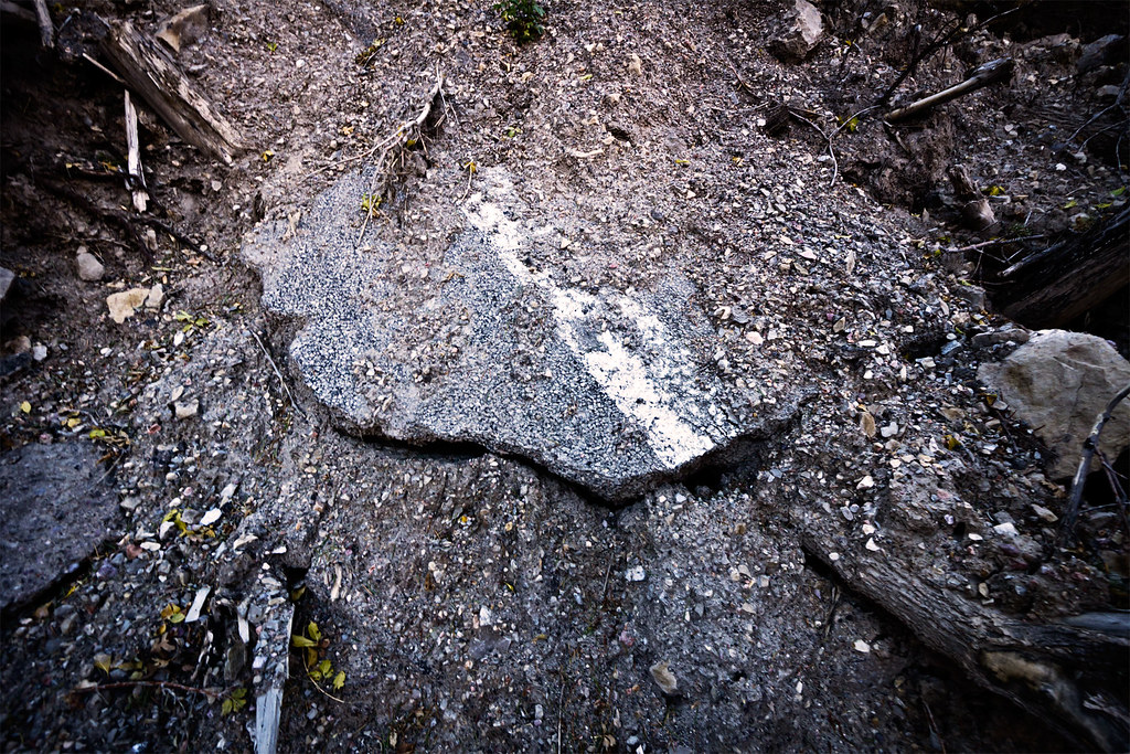
Slag by ashergrey, on Flickr
In spite of messes like this, I believe that Cedar Breaks will be Utah's next national park. Iron County has in recent years examined the impacts of pursuing park status for the monument. The economic benefit would be huge to Cedar City, Parowan and Duck Creek. An eventual park would doubtless consume the Ashdown Gorge Wilderness and turn this route (one of the few trails in the monument/wilderness) into a highlight. It certainly deserves the attention. I'm conflicted though, because parks draw tourists and Ashdown Gorge is a pretty special place to have all to one's self.
[PARSEHTML]<iframe src="http://www.mappingsupport.com/p/gmap4.php?q=http://dl.dropbox.com/u/3847512/GPS/Ashdown_Gorge.kml&t=t4" frameborder="0" marginheight="0" scrolling="no" width="800" height="800"></iframe><br><br>[/PARSEHTML]
Featured image for home page:

S.R. 14 is the terminus of the point-to-point route and a necessary drop point for one shuttle vehicle. In fact, the pull-off where one parks is exactly where the landslide hit. The closure of the highway for stabilization and repair work lasted into the summer of 2012, with full access not restored until September.
Thankfully, I'd secured some pretty great tickets to see Hamlet at the Utah Shakespeare Festival on the night of October 20th and, since I was going to be in Cedar City, decided again to try and make a go of Ashdown.
I left Salt Lake City after work on Friday the 19th and didn't arrive until very late. This is partly due to my feeling drowsy and opting to pull off in Scipio for a nap. When I at last rolled to a stop in Cedar Canyon the clock had ticked past 3 a.m. A cold wind howled down the dark canyon. I set out my bed roll into the back of the wagon, put the camera on its tripod and went to bed.
Cedar Canyon star trails by ashergrey, on Flickr
About 5:30 a.m. I roused and pulled the camera into the car. The wind still screamed. I snuggled down into my sleeping bag and drifted off again.
My phone alarm rang around 7 a.m. I ignored it. But 30 minutes later a loud knock on the window made my eyes snap open. I looked over to see my friend Jeff standing outside the car.
We'd agreed to meet at 7:30. I hastily dressed and popped out into the cold dawn. He tossed his bag into the wagon and we set out, driving the rest of the way up the canyon onto the Markagunt Plateau. The sun rising over cloudless skies made for stunning views of the Zion uplands and drainages of the upper Virgin. We didn't stop to photograph them as we should have, instead pushing to get on trail early.
Once at the Rattlesnake trailhead I scarfed down a cold breakfast of leftover pizza. A mountain biker came up the road from the direction of Brian Head as I was brushing my teeth and started asking us where the rim of Cedar Breaks was. Then he wanted to know where he could trail ride. With frothy paste dribbling down my chin I told him he was probably SOL because the wilderness boundary was only a few hundred feet away.
Scattered crusts of snow an inch or two deep ran alongside the trail as it worked toward the rim of the plateau. It was still cold even in the sunlight. We strolled along at 10,400 feet, enjoying the fragrant scent of old pine forest.
Once the trail drops over the edge of the plateau, it descends continuously until it reaches Rattlesnake Creek. Along the way you receive glimpses through the forest of the Cedar Breaks amphitheater off to the east. At Stud Flat, another exposed escarpment is revealed to the west. Most of the aspen at Stud Flat had already shed their leaves with the earlier snow. We did find a few though that still clung to autumn.
Aspens by ashergrey, on Flickr
The trail steepens as it switches its way down to the water. We followed Rattlesnake Creek along its west bank until obtaining the junction with the High Mountain Trail. This little waterfall is just feet away from the intersection.
Ice by ashergrey, on Flickr
Ice. Great. We had miles of water walking coming…
Although you can't see it from the trail junction, a waterfall blocks further downstream hiking (but we'll get back to it in a bit). Instead, you have to cross over a ridge separating Rattlesnake Creek from Ashdown Creek. This is accomplished using the Potato Hollow Trail. The first hint of what's to come is revealed after cresting the ridge.
Looking east, you can see the open forest from which Ashdown Creek flows and the distant bowl of Cedar Breaks.
At the creek we donned water-suitable shoes and began splashing our way down stream. The walls immediately rise and the waterway starts to slither.
Our pace slowed as we again and again crossed, following the course around corner after corner. The brilliant blue sky and radiant beams of sunlight falling on pale-colored rock, coupled with dark shadowed nooks made for challenging photography conditions. I ended up losing the highlights on many of my shots, despite continually upping shutter speed.
The water of Ashdown Creek was turbid and milky, making it hard to gauge stream depth and foot placement. It was surprising though that when we reached the Toms Head towers and reunited with Rattlesnake Creek, the water from that tributary appeared clear.
Toms Head by ashergrey, on Flickr
It left me to wonder what the big difference is. I'm assuming it's that Ashdown originates in the very ruddy face of Cedar Breaks, while Rattlesnake Gorge rises near Brian Head, away from the red rock. In any case, the side trip up Rattlesnake Creek is well worth the time. There's a little shelf waterfall along the way that is exquisite.
A bit farther up the side canyon the walls close in… the air takes on a chill and pockets of warming sunlight become valuable resources.
Rattlesnake Creek by ashergrey, on Flickr
The waterway splits again at the junction with Lake Creek.
At this point we're not far downstream from where we crossed Rattlesnake Creek previously. It's clear here why the trail takes the circuitous path. Both Lake and Rattlesnake Creeks tumble down falls not far above their junction. We headed up Lake Creek (the western fork) first. Its waterfall is pretty but not very photogenic at low flow. The water mists out, making it all but invisible to the camera.
One spooky moment came in this spot though. There were tracks in the mud that looked very much like cougar prints. I felt grateful that we hadn't stumbled on the big cat in this dead-end canyon.
The Rattlesnake Creek waterfall is the highlight of the hike. It's narrow and obscured by the canyon walls until you're right at the foot. I was only able to shoot one photo because the heavy mist and spray soaked my camera.
Falls on Rattlesnake Creek by ashergrey, on Flickr
Standing in this spot to take the photo left my feet numb to the point of pain. The water felt so cold it seemed to pierce my bones. The canyon is constricted enough that I'd be surprised if the floor sees more than a few minutes of sun a day.
We backtracked to Ashdown Gorge and continued our walk downstream. Amazing views waited at every turn.
An interesting feature of Ashdown Gorge is its coloration. Unlike most of southern Utah's narrow spaces, it is not carved from sandstone. The walls are mostly buff-colored limestone, but in places they take on a distinct orange hue. If you look close, it becomes obvious that the brighter color is actually the result of deposits carried down from Cedar Breaks. High water flows, by which I mean flash floods, splash the sediment high up on the walls. It dries there into a sort of patina.
High flows also carry a lot — and I mean a lot — of deadfall down from the Dixie National Forest. This logjam is waiting for the right storm to turn it into a devastating debris flow. Good luck to whomever is downstream when that happens.
Even low flows have their quirks. I found this little pit of quicksand by stepping in a one-inch deep puddle. My feet sunk down until they hit a submerged rock. The mud wanted to keep my water sandals.
Instead of staring at my feet though, I tried to keep my eyes up for Flannigan Arch while working through the deepest portion of the gorge. It would be easy to miss if you weren't on the lookout. It sits high on the east wall. I've read it can be spanned, but that involves picking a path up the steep slope. We had neither the time nor inclination for that side jaunt.
The canyon floor gradually widens beyond the Arch and the views reminded me of sections of Capitol Reef. If fact, the whole experience of Ashdown Gorge is really akin to Sulphur Creek in Capitol Reef… just with trees.
Once the gorge opens, deciduous trees join with the pines. Here we saw the only other group in the canyon that day. Two guys and a gal with a dog came up from behind and passed us as I futzed with a circular polarizer.
The worst part of the trip came at the end. In the past, the hike would have continued down Coal Creek a short distance to a dirt road. It provided access to the highway. However, the landslide that cut S.R. 14 resulted in a lot of boulders, torn up trees and other debris ending up in the stream. We couldn't see a simple way around the mess and instead opted to just climb right up several hundred feet of loose debris to the spot where I'd slept in my car the night before.
We were both exhausted after 12 miles of constant downhill and about 8 hours on foot. The loose scrabbly nature of the pile didn't fill us with a lot of confidence either. In fact, large chunks of the old highway surface are embedded in the rubble… beside countless beer cans discarded by the construction contractors.
Slag by ashergrey, on Flickr
In spite of messes like this, I believe that Cedar Breaks will be Utah's next national park. Iron County has in recent years examined the impacts of pursuing park status for the monument. The economic benefit would be huge to Cedar City, Parowan and Duck Creek. An eventual park would doubtless consume the Ashdown Gorge Wilderness and turn this route (one of the few trails in the monument/wilderness) into a highlight. It certainly deserves the attention. I'm conflicted though, because parks draw tourists and Ashdown Gorge is a pretty special place to have all to one's self.
[PARSEHTML]<iframe src="http://www.mappingsupport.com/p/gmap4.php?q=http://dl.dropbox.com/u/3847512/GPS/Ashdown_Gorge.kml&t=t4" frameborder="0" marginheight="0" scrolling="no" width="800" height="800"></iframe><br><br>[/PARSEHTML]
Featured image for home page:

")