Any Lake Powell experts who can advice on changed conditions at dramatically new lake levels?

Ross

Member
Joined
May 18, 2012
Messages
295
Happy New Year. For years I read up in Kelsey's Lake Powell book and other books and studied obscure websites with lots of info about hikes off Lake Powell. But the distances and some approaches - which may even be impossible now by boat or foot - will have changed now with current lake levels, but how much I don't know. So wondered if anyone had been to any of these at near current levels. In Kelsey's book he was talking about 3606 being low. Now it's 3524.

IN ESCALANTE ARM, can you still get to the entrances of DAVIS and FIFTY MILE?
Are there any problems getting to La Gorce Arch or 50 Mile Creek's narrows such as waterfalls, very hard upclimbs, quicksand, logjams, bad bushwacking,

I presume it's now a really long hike to the mouths of FENCE and COW canyons in Escalante arm.

Are there any stunning features or slots that have now been revealed in Escalante arm? (or anywhere else on the lake for that matter? (My dream is for Dungeon to emerge as it looks stunning in pre-Glen Canyon dam photos

Also interested in ICEBERG canyon. I presume the canyon's end right fork is still pooled by a natural dam? Wondered how far you have to hike from high water mark to reach that dam if that's changed?
One person pre-new low levels said you need to drag a kayak over the dam in order to cross the lake to hike on to alcoves and caves at the end of the canyon when lake water is high? But maybe that lake has shrunk now so you can hike around its edges?

(These were the notes on Iceberg for someone who has explored loads of the Powell' canyons hundreds of times a long, long time ago after the Glen dam, but when Powell levels were considerably higher.
  • (!) ICESRF: Iceberg second right finger, 0.77 miles GPS direct, ~0:45 one way from brushy end at full-pool up and down on decent braided trails to huge sandy flat, gardens, and pool; probably the biggest amphitheater at the lake, bigger than even "Dougs Cathedral", with a comparable 600-700' drop from the rim. You can also overlook this spot. Awesome cave on river-left along the way, not very big by Powell standards, but the greatest depth-to-height ratio I've seen at the lake. (Obstacle to getting here: Below full-pool, natural dam forms a lake up the finger, you'd have to drag a kayak over or something. Do it at full-pool, or else much lower, when it's a much longer hike.)

Finally
How long is the hike now to FACE's slot?
And how long is the walk to the narrows in SMITH FORK?
 
Was in Llewellyen Gulch and Cotonwood Gulch a couple years ago.... from upper lake level was long brushy hike with stretches of mud to the lake.
New level was roughly 1 1/2 m down from where it shows on the map. Would expect most other canyons are the same.
 
Hi Ross,

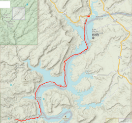
I don't have information on the specific canyons that you mention, but I did do some hiking along the shoreline of north Lake Powell (or more accurately, the edge of the Colorado River !) last year (map below).

You are correct that the falling water level is revealing some interesting 'new' areas to explore in this region.

For most of my route, it was fairly straightforward to negotiate the terrain, which mostly comprised white sandy beaches or deeply fractured dry mud. However, close to 4-Mile Canyon the wet mud/quicksand was difficult to traverse, although I got there in the end.

I usually rely on satellite images from Google Earth, when planning a backcountry route, but due to the dramatic changes to the Lake Powell topography over recent times, I also found it useful to use websites which display very recent (although not quite so detailed) satellite images. These give a pretty good idea of the current water levels in a particular canyon.
For example, https://www.sentinel-hub.com/explore/eobrowser/
.
.
.


Lake Powell Hike Screenshot April 2022.png
 
Thanks @TrailScot . You made me think, after I said about new areas, I should have said if people don't feel keen to say somewhere in a reply then by all means PM, although as I'm asking about places newly-revealed close off the main lake that are in the middle of canyons at the bottom of streams/rivers/creeks, they're not going to be either hidden away secrets or places that are delicate and could be damaged by numbers or hiking boots, and also on Lake Powell they're never going to attract crowds. Basically if you moor a boat up when the deep water ends you'd just have to stroll on up the canyon a short ways as it's not like finding a high hidden slots, or using bolts and rope grooves. I gave the example of submerged Dungeon Canyon - if the lake dropped to reveal that you'd just walk straight up canyon through the slot, so it would be pointless keeping it a secret. (Also thought I'd tag @Nick and @ram (hope you're well) on the original canyons in the question as I know they're long-time lake lovers & explorers/visitors who've probably still been going strong the past few years
 
Similar threads
Thread starter Title Forum Replies Date
J Lake Powell at 3528 feet General Discussion 1
TrailScot Lake Powell and the 'return' of Glen Canyon General Discussion 24
Duketogo13 Questions about packrafting the Escalante/Lake Powell in September. Need help! Trip Planning 5
S Packrafting Escalante - FiftyMile Creek and low water level Lake Powell Trip Planning 8
D Coyote Gulch to Lake Powell Trip Planning 8
JDWalters Access to Escalante River/Lake Powell near Cathedral in the Desert Trip Planning 7
Ross Invite Lake Powell canyons(Iceberg,Davis,Willow)or Cape Solitude/Canaan Mtn Meet Up (Members Only) 1
Ross Anyone for Lake Powell canyons (Iceberg,Davis,Willow/Cape Solitude/Canaan Mtn Trip Planning 0
DrNed Kayaking Lake Powell Trip Planning 3
CaptnKidd North End of Lake Powell and Southern Tip of Capitol Reef Hiking & Camping 11
lostlandscapes Smith Fork & Lake Powell, January 22-24 Hiking & Camping 22
Udink Lake Powell - Stanton Creek On The Water 9
Christian Lake Powell: Anasazi, Lehi Bridges, North Fork Forgotten Canyon, etc On The Water 2
Nick Floating Hite to Lake Powell Trip Planning 2
heronwheels Shoreline Fishing - Lake Powell Trip Planning 7
Nick Desert Magazine 1963: Lake Powell General Discussion 10
Nick Before Lake Powell / Memories of Glen Canyon General Discussion 0
Nick North Lake Powell On The Water 19
Nick Kayaking Lake Powell - Moqui Canyon On The Water 19
E Kayaking and Hiking in the Rainbow Area, Lake Powell. 4/7-4/13/13. On The Water 2
E 6-7 Days DIY Kayaking and Hiking on Lake Powell? Trip Planning 2
Nik Lake Powell Trip in September Trip Planning 6
scatman Grebe Lake - September 4th through the 6th, 2024 Meet Up (Members Only) 20
K How long in Lake Bled? Trip Planning 1
wsp_scott Yellowstone Lake to Brooks Lake (Aug 2023) Backpacking 16
Mikjik86 Backpacking Indian Peaks Wilderness - King Lake - August, 2023 Backpacking 0
Ugly Two Popular Lake Basins in the Cascades Backpacking 12
TheMountainRabbit Ortenburger Lake, Talus Lake, & Glacier Peak (Grand Teton NP) - October 2023 Backpacking 14
kwc Fall hike to Chase Lake, Southern Adirondacks Hiking & Camping 1
TrektheWorld Red Deer Lake & Beyond Backpacking 10
shredhiker Thorofare, Heart Lake, Snake River Sept. 2023 Backpacking 16
Bob Wind Rivers - Short Trip to Cook Lake Trip Reports 9
regehr (Uintas) Lake Fork Fun Backpacking 8
Timber High Sierra - North Lake to South Lake Loop - Layover Day Trip Planning 9
kwc Limekiln Lake paddle On The Water 0
shredhiker YNP Fawn Pass to Sportsman, Crescent, Shelf Lake Backpacking 11
Bob The Thorofare to Brooks Lake - 9 Days in Pictures Backpacking 10
Janice Lizard Head Plateau - overlook Upper Cathedral Lake? Trip Planning 15
uintafly Chepeta Lake to Hayden Pass Trip Planning 0
DrNed Naturalist Basin: Blue Lake to Shaler Lake? Trip Planning 12
shredhiker YNP Fawn Pass to Sportsman & Crescent Lake Trip Planning 14
kwc Jockeybush Lake- southern Adirondacks Hiking & Camping 0
shredhiker Yellowstone Heart Lake September 2022 Backpacking 9
TheMountainRabbit Black Lake (Rocky Mountain NP) - January 2023 Hiking & Camping 3
NorthwestWanderer Backpacking Grand Teton National Park : Fossil Pass,Fox Creek Pass,Indian Lake,Alaska Basin,Hurricane Pass,Ice Floe Lake,& Snowdrift Lake Backpacking 19
NorthwestWanderer 8 Day High Sierra trek : Humphreys Basin, Star Col, Granite Park, Lake Italy & Piute Canyon 6/25-7/2/22 Backpacking 7
TractorDoc Yellowstone's Wrangler Lake, Bog Creek, Joseph's Coat Springs, Broad Creek, Wapiti Lake, Hot Springs Basin, and Pelican Valley. The Second Half. Backpacking 15
kwc Another Southern Adirondacks hike - Clockmill Pond and Rock Lake Hiking & Camping 0
TractorDoc Yellowstone's Wrangler Lake, Bog Creek, Joseph's Coat Springs, Broad Creek, Wapiti Lake, Hot Springs Basin, and Pelican Valley. Part One of Two. Backpacking 61
kwc Round Lake, north central Adirondacks, in the Round Lake Wilderness On The Water 2

Similar threads

Back
Top