Here's the full trip report, as promised. Again, all photos are here:
https://picasaweb.google.com/balzaccom/PeruSantaCruzTrek2015#
And the illustrated version of this report is here:
https://sites.google.com/site/backpackthesierra/home/our-blog/thesantacruztrekdaybyday
Day One:
We had spent the previous two and a half days acclimating at about 10,000 feet in Huaraz, having taken the noon bus from Lima three days before. The first day after we arrived we walked around town and saw the sights (including the pre-Inca Killkawain ruins outside of town) and did some shopping. The second day we took an organized tour of the much more ancient Chavin de Huantar ruins—an all day trip to the eastern side of the Cordillera Blanca.
The good news for hiking the Santa Cruz in this direction is that the first day is not a tough one, so you don’t need to leave the hotel before dawn. Our guide Hector picked us up at the very civilized hour of 7 a.m. We picked up our hiking companion Kalie, a fit young woman from Pennsylvania who had been doing volunteer work in Cuzco, and we were off.
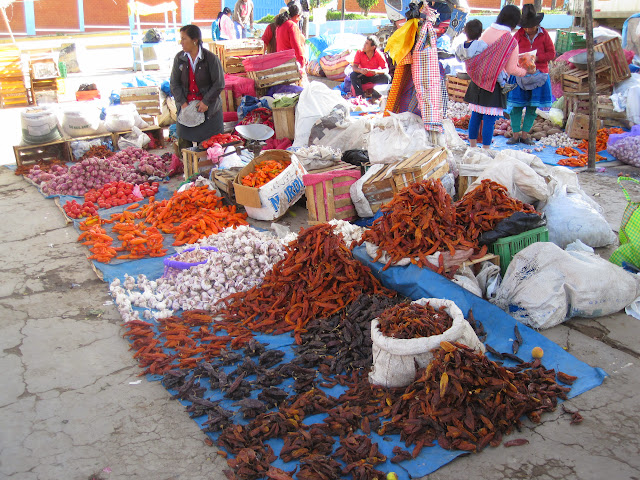
From Huaraz it was an hour drive down the valley to Caraz, where we turned off and climbed a tiny dirt road for two hours up to the trailhead, in the hamlet of Cashapampa. This is where we met Clemente our arriero or muleteer, who would manage the donkeys that took a lot of our stuff.
The weight limit per person was 12kg, but of course, as lightweight backpackers, this was way more than we needed—especially because we wouldn’t hike with the donkeys, so anything packed on them was gone for the day. We sent our sleeping bag and extra clothes with the donkeys, as Hector was providing both tent and two sleeping pads person. And the donkeys had all of our food, the kitchen and kitchen tent, a “toilet tent” and Hector and Clemente’s packs as well. We hiked with our rain gear, a warm jacket, a few snacks, bug juice, water, and our “box lunch” from Hector in our packs.
The trail starts at 9,500 feet, and starts climbing up along the Santa Cruz River immediately.
But don’t think that 9,500 feet is alpine. The vegetation here was almost tropical, and in Cashapampa there were fields of corn, amaranth, and tons of flowers and fruit.
And the temperature was in the mid 70’s and humid.
The trail climbed steadily, and it was enough for us to ignore the warnings about mosquitoes to roll up our sleeves and take off the legs of our pants. Hot sweaty work. But the river was tumbling and roaring down the canyon, and we had plenty of reasons to stop and take photos and a rest. Only later did we discover that the mosquitoes look different from our Sierra bugs...but do the same kind of damage. We were all bitten a few times.
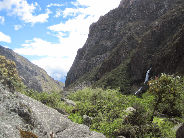
At around 1. P.m. Kalie and I arrived at a lovely waterfall right by the side of the trail, and we picked this as the spot to eat lunch. Bromeliads covered the nearby trees and hills, and it was pretty darn spectacular. The elevation was about 11,000 feet.
This is also where we learned a little more about Hector and his company. The lunches were extensive. Each of us had two sandwiches, (including an avocado sandwich—the avocados in Peru are phenomenal) a piece of fruit, a box of juice, cookies, energy bars, chocolate, dried fruit, crackers…in fact, we found each day that our initial stock of snacks that we had packed was steadily increasing, as we could never eat all the food they had given us each day. What a luxury on the trail! We brought some of those snacks back to the US at the end of our trip...
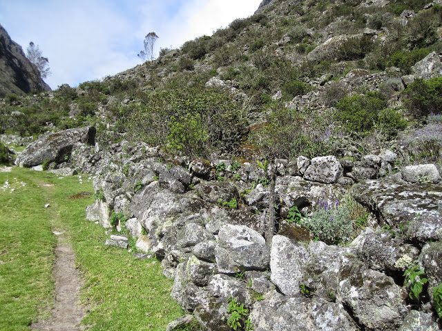
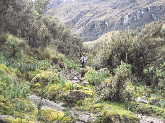
After lunch, the trail settled down a bit, and we followed the river up a huge glacial canyon. The local population still used this part of Huascaran National Park as grazing grounds, and there were often donkeys, cattle or a few horses in sight. But there were also pre-Incan stone corrals, which indicated that the area had been used this way for something like 800 years.
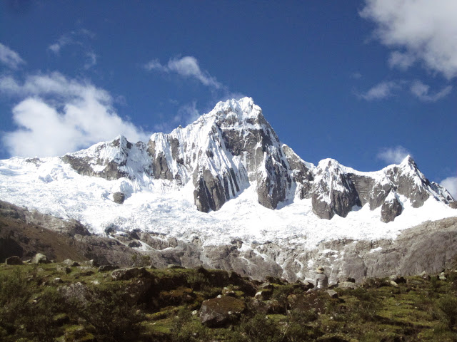
As we worked our way up the canyon, waterfalls were cascading down the sides, and occasionally we were give a glimpse of a towering peak behind the canyon walls. We got to camp about 3:30 and set up next to one other hiking group at 12,000 feet.
Dinner that night was a classic Peruvian appetizer of fried won tons with guacamole, soup, chicken filets with rice, fruit, dessert, and as much hot water for coca or regular tea, whichever you preferred. Again, it felt sumptuous at that elevation. A big wind came up right after dinner, and we spent most of the night listening to it howl and shake the tent. We were thankful to Hector for the solid four-season tents he had provided.
A note about the campsites: these are specific locations along the trail, and everybody is supposed to camp in that area. They were originally provided with stone pit toilets, but those are now completely unusable, so we had a small tent with a hole in the ground for our toilet. They are generally large open fields with lots of room...but not a lot of privacy.
Day Two:
This was to be the easy day, although there were a few adventures in store. We were awake at six, and supposed to be packed up by 7 and in the dining tent. At 6:30 Clemente delivered a small bucket of piping hot water to our tents, so that we could wash up a bit. We found the schedule quite easy, and were often in the dining tent well before 7. Oatmeal, fruit, toast, hot cocoa (and coca tea) for breakfast. By 7:45 we were on the trail, ahead of both Hector and Clemente. Hector stayed behind to help Clemente a bit, and we set off down the trail. Within a few minutes, Hector had caught up with us, and we walked comfortably up along the gradual rise of this valley, always on the southern side of the river.
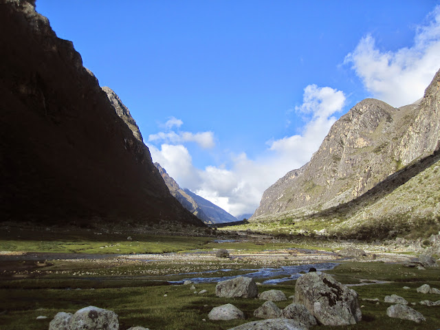
This was pretty easy walking for the first few hours, and then we came to Lake Ichicocha. Beautifully set into the heart of the canyon, this lake was a talisman for many miles afterwards. Above the lake, the remains of a massive landslide dominated the canyon. It had happened some years ago, far above in one of the side canyons, but was so massive that it blew out a lake far above, and carried that sediment down all the way to Ichicocha, filling in another lake (Juntacocha, which still appears on some of the maps of this area) along the way. Quite impressive, and a good reminder that these mountains are still quite alive! Our guide Hector--trained as a journalist, was extremely thoughtful and insightful on a wide range of topics.
Above the lake, the landslide had covered up the old trail, and we were surprised by a tiny traverse of class 5+ rock climbing to get past a tight point. M was suitably nervous, but passed the test with flying colors and a small assist from Hector. But after that, it was a few miles of walking over the dead flat rock and sand of the catastrophe, to eat lunch in the first spot of greenery, just across a small bridge at the foot of the next steep section of the canyon.
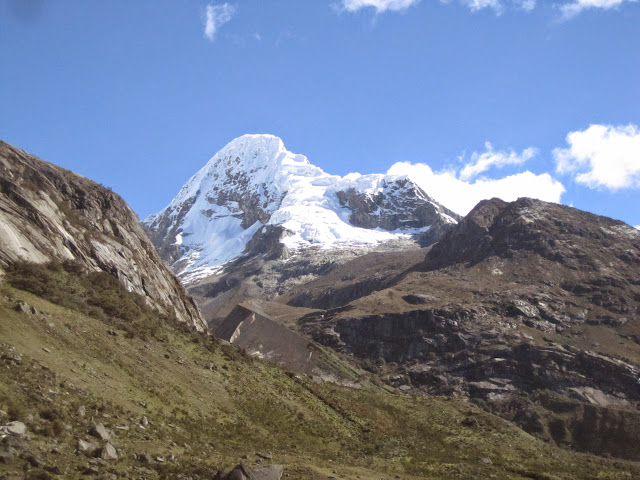
Another filling lunch led to a discussion of our route from here on out. The simple route was straight up the canyon to camp. The alternative was an hour longer, but would take us up a steep trail that switch-backed up the side canyon that would give us a better view of Alpamayo, the “most beautiful mountain in the world.” Who could pass that up?
We found the trail not that hard….and Kalie and I actually hiked past the turn-off to our camp in our enthusiasm. But a few hundred yards past it, we stopped to enjoy the view and hope that the clouds would part for a clear view of the peak. They did. And Hector and M arrived just minutes later to lead us to camp.
As we hiked this last section we could see the whole valley below us, including the lake and even a small section of the Cordillera Negra opposite us. Spectacular.
Camp here was at 13,400 feet, and it was more crowded, as this was a key spot on the trail, and groups heading both directions were camped here. But the setting was stunning. And as we enjoyed the view, the clouds blew away, the peaks came out into full view, and even a pair of condors sailed overhead. This was well worth the trip!
Here is where we also heard some sad stories from some of the groups who had paid less for their trips. One group learned that they had paid for a four-day trek, and were going to do the hike in three days. Anyone who disagreed would be left behind without food or shelter.
There were people who complained that there wasn’t really enough food for the group (one serving for each person, and some of the young guys were really hungry) others whose tents leaked or seeped water, etc.
Our hike was flawless in this regard, and we really liked both Hector and Clemente. Hector, in particular, seemed to know everyone on the trail, greeted them all as friends, and was accorded great respect by the other guides and arrieros.
A dinner of hot buttered popcorn appetizer (!) soup, trout filets, and chocolate pudding left us with lots left over! And afterwards, we watched the sun go down and cast a rosy glow on the surrounding peaks.
That night, however, it rained all night long. In our tent, we worried whether the hike of the pass (15,500) would be possible the next day.
Day Three:
It was still sprinkling when we woke up, but by the time we were into a breakfast of eggs and toast, juice and hot beverages, it was down to a very light and occasional drizzle. And that continued, off and on, for most of the day. Again Hector sent us out on our own for the first twenty minutes, while he assisted Clemente in packing up camp. He knew that he would catch up quickly…and Clemente, even though we know he left camp an hour after we did, always beat us into camp by hours.
This was a steep climb. From the campsite it was about 2.5 miles, and we would climb over 2,000 feet in that distance. But this part of the trail was stunning. We were surrounded by peaks, albeit often with their heads in the clouds, and views back down the canyon to our campsite and beyond.
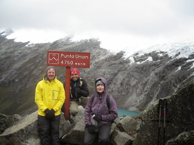
After the first mile we could begin to see the small lake below Mount Taulliraju, as well as other hikers (and Clemente and his donkeys) working along the trail below us. Parts of this trail had been built by the Incas, and it was a pleasure to hike it. It took a good two hours to get to the pass, Punta Union, which is at 15,617 feet. As we rested here, Clemente passed us by.
The following section was nowhere near as pleasant. Equally steep, but with jumbled boulders everywhere, it was slow going down this side of the pass. And while there were some lovely lakes below, we were now having the worst day-time weather of the trip, with rain and hail showers in between minutes of intense sunlight. The surrounding peaks were generally hidden by the clouds.
We ate lunch along the shores of one of the many lakes in this section, but then came the worst part of the trail. About six miles of pure, unadulterated mud, often six to ten inches deep. Hector did his best to pick a path through the mud that kept his (and our) feet dry, but this often involved rock hopping, climbing well above the actual route of the trail, and endlessly slow going. That's the mud, below. Six miles of it.
But the scenery in this section was amazing. We kept thinking of Jurassic Park as we hiked through this fantastic setting of towering peaks, jungle vegetation, and cascading water on all sides.
In the end, it took us just about ten hours to hike those twelve miles—and we had certainly used up all of our water by the time we collapsed into camp at 5:30. We were at a little over 12,000 feet here.
Hector, amazingly, set immediately to cooking dinner, and by 7:30 we had soup, spaghetti, dessert, and as a special treat for all of our hard work, hot mulled wine afterwards. Incredible.
Kalie struggled on this day. She had started very strongly (Hector told us later that he thought she had pushed too hard on the first climb, and never really recovered.) but after the pass, she began to feel poorly. She could still hike faster than we could, but she was not feeling well at all, and eventually Hector sent her on ahead. She said later that it was enormously difficult. She was probably dehydrated, certainly suffering from the altitude, and in the end went straight to bed before eating any dinner. Hector insisted that she drink some tea before sleeping that night, and by the next morning she was partially, if not completely, recovered.
Day Four:
This was a piece of cake.
A stroll down the canyon was on a perfectly good trail, with no mud and no boulders. We were in high spirits. We stopped in at the National Park office to get our permits and chat with the ranger. And then it was a nice walk down to the tiny town of Huaripampa, (elevation 11,000) where the local children had already learned that we might be carrying cookies. (When we made our reservations for this trip, our contact in Peru had suggested that we bring pencils or ballpoint pens for this situation. The school was always short of supplies…)
So we began to give out little pens, and we were extremely popular for a few hundred yards.
There is a road to Huaripampa, but it is so long and rough that the trek doesn’t end here. Instead, it climbs another 1,000 feet along trails and roads to reach Vaqueria, where our van awaited. Here we could buy sodas, use a clean restroom, and get settled in for our long drive back to Huaraz. And here we said good-bye to Clemente’s four-legged friends.
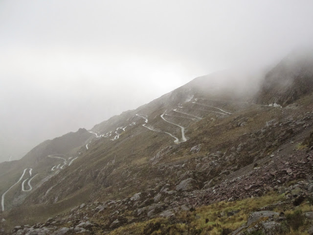
But we were not prepared for the scenery of the drive that followed. Starting at 12,000 feet it soared and climbed up to 15,600 feet at the pass, with snow, rain, and hail on the way, and then dropped down through endless narrow switchbacks for more than two more hours. Along the way we passed the shrine to those who went over the edge on a hairpin turn a few years ago, killing everyone on the bus.
It was stunning, electrifying, and we are happy we don’t have to do it very often!
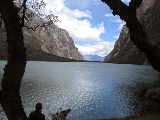
We passed a small local rodeo where the local veterinarian was treated the cattle, drove alongside the glorious Llanganuco lakes, where we stopped to take the photo below, and eventually dropped back down into the valley near Yungay, where a massive avalanche from Mt. Huascaran had completely covered the city in 1960, killing virtually everyone in town.
By that time we were back on a paved road, and it was an easy drive back to Huaraz. We checked into the hotel, took long, reviving showers, and enjoyed a great dinner at a local restaurant. We were back in civilization.
This was a great hike, and we enjoyed all of it. We were very happy with Hector, whom we hired through ActivePeru in Huaraz. In Huaraz, the local contact is Romer, who was also full of information and very considerate. We stayed in relative luxury at the Hotel Santa Cruz, although Kalie spent only about $10 a night to stay in a local hostel. While Huaraz has 80,000 inhabitants, it's a small town at heart. There are lots of shops selling anything you might have forgotten for your trek...albeit maybe not exactly what you might buy in the US. And there are many, many agencies offering to organize any adventure you would like. Caveat Emptor---not all of them can deliver, and some of the ones with the nicest offices have terrible reviews on tripadvisor.