An Allen inspired trip to Dark Canyon

Your TR's are very helpful--thanks! Could you please describe the "talus side-hilling" on the ramps to rejoin the Allen high route just before leaving Dark? Would you call it a class 3 scramble using Allen's ratings, or more like class 4 or higher? Is the best path simple/obvious, or is this in the realm of your ultra-crux alternate that non-technical hikers should avoid?
 
Your TR's are very helpful--thanks! Could you please describe the "talus side-hilling" on the ramps to rejoin the Allen high route just before leaving Dark? Would you call it a class 3 scramble using Allen's ratings, or more like class 4 or higher? Is the best path simple/obvious, or is this in the realm of your ultra-crux alternate that non-technical hikers should avoid?
Thanks, the alt canyon I went up to rejoin the Allen route was class 3 max. I didn't personally find the routefinding there challenging, but I spend quite a bit of time off-trail. I thought it was nice alternative to maximize proximity to water sources and enjoy the lower canyon. Allen's ratings are soft sometimes IMO, but class 4 - low 5 is fuzzy in the climbing world.
 
Thanks, that'll make the water carry easier. Yeah, I can tell you have significant off-trail experience and move at Kelsey speeds because I did a slightly longer version of the Stevens/Fold route after reading your TR and watching My Own Frontier's video. I aimed for 5 days, packed food for 6 days, and it took me 7 days. :)
 
Thanks, that'll make the water carry easier. Yeah, I can tell you have significant off-trail experience and move at Kelsey speeds because I did a slightly longer version of the Stevens/Fold route after reading your TR and watching My Own Frontier's video. I aimed for 5 days, packed food for 6 days, and it took me 7 days. :)
I hope it wasn't too brutal. I'm not necessarily that fast, but I am willing to walk for long periods of time :)
 
It was quite brutal, but also my favorite trip ever. This'll be my first time in Dark Canyon, so I'm excited and optimistic after all the Utah snow I read about.
 
I'm with you; I'm ready to do Stevens/Fold again. The one thing you might want to keep an eye on is the snow/mud situation on the rim. Those dirt roads on the rim contain quite a bit of clay and can turn into a major slog (more so than when I went) if it's muddy.
 
Not sure what all you’re planning for but if the escalante route took a little longer than expected I’ll put out there that Dark area is quite a bit more difficult hiking than Escalante (though maybe my memory is jaded by a 4th of July 100+ degree Gypsum/Bowdie loop haha). More elevation and the bypasses tend to be monsters.
 
I'm with you; I'm ready to do Stevens/Fold again. The one thing you might want to keep an eye on is the snow/mud situation on the rim. Those dirt roads on the rim contain quite a bit of clay and can turn into a major slog (more so than when I went) if it's muddy.
Ah, thanks--I only have a 2WD SUV. I'll have driven around the state a bit before Dark Canyon because I plan to do a 2-night section of the Beehive Traverse beforehand (maybe I should plan 3 nights!), so I'll be able to get a sense of mud conditions. Worst case scenario, I guess it's only 5 hours of muddy road walk from pavement to the Sundance trailhead.
For selfish reasons, I hope you try a variation on Stevens/Fold like Cliff/Georges Camp so I can read a new TR!
 
Not sure what all you’re planning for but if the escalante route took a little longer than expected I’ll put out there that Dark area is quite a bit more difficult hiking than Escalante (though maybe my memory is jaded by a 4th of July 100+ degree Gypsum/Bowdie loop haha). More elevation and the bypasses tend to be monsters.
You're right, so I'm going to leave Gypsum for another day... hopefully with packrafts all the way to Hite to avoid the hike out. For this April, I was initially thinking of only going up Youngs and down Lean-To, but if I'm driving all the way to Utah I figured I'd try something longer. I'll plan the Allen route for Bowdie, but with options to bail from Midway to Lean-To if I'm having too much difficulty.
Anyone have thoughts on how this thread's route compares to only a Young's/Lean-To route in terms of difficulty/beauty?
 
Logistics-wise you can for sure get to the upper Sundance TH in your car. Sweet Alice is more problematic from a ruggedness standpoint, plus mud. It's higher elevation and has long stretches of shade and places where the snow drifts/collects on the back side of the Bear Ears saddle. You might consider going in from the bottom this time of year.

Jamal has some good photos of Youngs to get a sense of the scenery.

p.s. PM if you are doing the off-trail section of the Beehive Traverse and need beta. There was one section that was not obvious from a map.
 
Fossana,
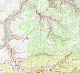
Read your report and it brought back fond memories of our 1998 Steve Allen inspired Dark Canyon walk. We added a few worthwhile variations to his basic route. We went down Bowdie a bit and then up and out the north side for an overland to look in Gypsum Canyon at North Point. Then our own take on getting back to Young's Canyon for the return home. We don't recall Bowdie as being particularly problematic, but the trip was almost 25 years ago...

We did not carry a camera on the trip, they used film in those days and we thought we already had enough Utah pictures from previous trips, so looking at yours is a treat. Thank you so much for posting them.

Below is a map of our route:

Screen Shot 2021-07-01 at 8.46.10 PM.jpg
 
That looks like an interesting variation. Thanks for sharing, James.
 

Don't like ads? Become a BCP Supporting Member and kiss them all goodbye. Click here for more info.

Back
Top