Amazing Discovery in Utah-Glen Canyon

Ugly

Life really is better Here
.
Joined
Apr 20, 2013
Messages
1,154
It’s with the BLM Archaeologist now…
See what they say.

I think it is likely just a natural oddity. It seems where it is, is not that steep, so it would be subject to a lot of erosion. There is also a lot of crossbedding around there and some similar features just south.
As for getting there, I looked at my pictures and still cannot remember if the middle fork of Annie's is still hikeable. For sure the north fork is a big alcove, because we ate lunch there. Once in Annie's one should be able to get onto the Fold, but there are potential barriers, and slots/pouroffs that come along with that area.

Ironically, I was 10 miles due west of that spot last weekend. Wrong canyon complex and a few canyons in between.
 
Joined
Nov 28, 2022
Messages
29
See what they say.

I think it is likely just a natural oddity. It seems where it is, is not that steep, so it would be subject to a lot of erosion. There is also a lot of crossbedding around there and some similar features just south.
As for getting there, I looked at my pictures and still cannot remember if the middle fork of Annie's is still hikeable. For sure the north fork is a big alcove, because we ate lunch there. Once in Annie's one should be able to get onto the Fold, but there are potential barriers, and slots/pouroffs that come along with that area.

Ironically, I was 10 miles due west of that spot last weekend. Wrong canyon complex and a few canyons in between.
So the two I have spoken to are very intrigued.They did confirm It does not come up in the Utah Historic preservation files. So, assuming it is ‘something’, chances are no one has seen it. Don’t want to get ahead of myself, but this is so cool lol. Thanks all!
 

Brendan S

Member
Joined
Mar 19, 2016
Messages
398
See what they say.

I think it is likely just a natural oddity. It seems where it is, is not that steep, so it would be subject to a lot of erosion. There is also a lot of crossbedding around there and some similar features just south.
As for getting there, I looked at my pictures and still cannot remember if the middle fork of Annie's is still hikeable. For sure the north fork is a big alcove, because we ate lunch there. Once in Annie's one should be able to get onto the Fold, but there are potential barriers, and slots/pouroffs that come along with that area.

Ironically, I was 10 miles due west of that spot last weekend. Wrong canyon complex and a few canyons in between.
I've hiked near the spot (and actually camped just a couple hundred meters from there) a few years ago. I'd say it definitely isn't a spot that would get much Lake hiker traffic, though there is a very old mining track somewhat nearby. I kinda agree it is probably a natural oddity. Some similar geology along the same drainage in other spots. Very cool area though.
 

Ugly

Life really is better Here
.
Joined
Apr 20, 2013
Messages
1,154
I've hiked near the spot (and actually camped just a couple hundred meters from there) a few years ago. I'd say it definitely isn't a spot that would get much Lake hiker traffic, though there is a very old mining track somewhat nearby. I kinda agree it is probably a natural oddity. Some similar geology along the same drainage in other spots. Very cool area though.
You would be one of my first guesses, if anyone had been there.

I was just reading In the book The Glen Canyon Country it mentions that one group of archaeologists drove down to the area Long Creek Canyon. If so, it would have been a mining track somewhere along the Fold, and possibly nearby.
Long Creek and Bowns canyon/Bechan Cave are cool in their own regard. They have been on my list for a while.

Interesting to see if anything more comes of this.
 
Joined
Nov 28, 2022
Messages
29
No update as of yet. I am trying to stay skeptical, however, I will say this…
Out of everyone I have been in contact with, including the BLM archaeologists, the idea that this spot might be so remote that no one actually has seen it (which I honestly figured was 0%), is growing more and more real. Obviously could be shadows, etc., but that is why I went to the local community of experts, instead of jumping in the next flight lol. Thanks all
 
Joined
Nov 28, 2022
Messages
29
You would be one of my first guesses, if anyone had been there.

I was just reading In the book The Glen Canyon Country it mentions that one group of archaeologists drove down to the area Long Creek Canyon. If so, it would have been a mining track somewhere along the Fold, and possibly nearby.
Long Creek and Bowns canyon/Bechan Cave are cool in their own regard. They have been on my list for a while.

Interesting to see if anything more comes of this.
Ok, so the archaeologists got back to me. They reached out to a Navajo representative, who also confirmed that they have no survey data from this area either and doesn’t know of anyone who would. He also mentioned the old mine trail by Schock Bar(?), that someone here mentioned was in the area, and he said it would be 3-4 miles from that location. He is intrigued as well and mentioned that if anyone does plan a trip, he would love to go! This is amazing.
 
Joined
Nov 28, 2022
Messages
29
So, I have been in contact with BLM, NPS and Navajo representatives. While some do believe it is nothing more than water erosion of rock, shadows, etc. and likely natural, a few things are confirmed:
1. Despite the surrounding well known sites, trails, boaters, etc..; it is a very remote site.
2. Only way to access it (without hiking 10+ miles one way), would be through one of two canyons from the water.
3. There is no historical documentation of Native art/glyphs, etc for this area, nor any survey data.

They did agree it is very intriguing, obviously can’t say without having actual eyes on it. The Navajo representative also stated as I mentioned before, that if someone does plan a trip, he would love to go.

I have family nearby in Durango, I could potentially be taking a trip in the semi-near future, but if anyone else plans a trip, please keep me in the loop. I would love to see what it really looks like close up. Thanks again to everyone for all of the information that was provided.
 

dcsmith1212

New Member
Joined
Dec 1, 2022
Messages
1
If anyone would like to PM me, I will provide the coordinates.
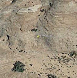
Hey there, new to the forum but I am headed to GCNRA tomorrow and I'm still undecided on where exactly I want to do some backpacking, so would love to see where exactly this is at. Sent you a PM to get the coordinates.
 

pinyon_juniper

New Member
Joined
Apr 29, 2016
Messages
1
Looking at historical imagery on Google Earth I'm pretty sure it's just shadows on the crossbedding, lot's of textures in those rocks.
 

Attachments

  • lk powell.jpg
    lk powell.jpg
    306.1 KB · Views: 94

Bob

Trailmaster
Joined
Mar 3, 2013
Messages
3,645
lower left corner on GE, after you zoom in a little a date showsup.... click that and brings photo timeline up in the upper left corner....
 

Ted

Member
Joined
Oct 1, 2022
Messages
18
Even if it were "real", the fact is, people have been pulling archaeological pranks for hundreds of years. Years ago on a van trip through Wyoming, I think on a two-lane highway to Casper, the driver stopped at a remote informal rest area kind of wide spot in the road. He pointed out some really creepy looking faces carved into the rock, they had been done in historical times, but were probably fairly old.

Go Ogle Earth is definitely a time sink!
 

CodyL

Member
Joined
Jan 23, 2018
Messages
81
Even if it were "real", the fact is, people have been pulling archaeological pranks for hundreds of years.
Ha ha this is true! It wasn't built as a prank, but a good local example for me is a granary in Canyonlands that gets a lot of attention and pics of it posted. This topic would be an interesting thread or make a good discussion around a fire. On second hand, maybe I don't want to find out some of the things I've searched for in the backcountry aren't authentic lol.
 

Bob

Trailmaster
Joined
Mar 3, 2013
Messages
3,645
False Kiva ......... example
 

CodyL

Member
Joined
Jan 23, 2018
Messages
81
False Kiva ......... example
Yep Bob! I thought of that one too. Granary I mentioned above is by Lou's Spring in Ernies country. It was built in the 90s by a Professor and a few students. I'm not sure why the NPS hasn't broken it down- maybe at this point they figure why bother.
 
Similar threads
Thread starter Title Forum Replies Date
BJett Amazing Appalachians - Backpacking/Packrafting the AT and Nantahala River Backpacking 5
SteveR Amazing Akamina Ridge Hiking & Camping 4
norwegianxplorer Ski Dogs, Norway, fun days off piste ski touring amazing conditions Winter Sports 0
K Amazing Sunrises and Sunsets General Discussion 0
Reef&Ruins Amazing Photos from An Air-Freighter Pilot Photography 0
TJ Sheridan AMAZING Fantasy Canyon - Pics & Film Hiking & Camping 17
xjblue The Amazing Maze, Sept. 2011 Hiking & Camping 13
Dave Amazing historical resource General Discussion 4
Stickerbumper Uinta Discovery Trail 2018 Backpacking 17
Deadeye008 Bear Grylls Fired by Discovery! General Discussion 15
Seldom Seen Anderson "Discovery" of Vermilion Cliffs General Discussion 8
Martyn Hi from Hurricane Utah! Noobs: Introduce yourself! 0
B Good trips in Southern Utah given current conditions Trip Planning 26
saltybird SE Utah NPs in April Trip Planning 12
C Grand Gulch Cedar Mesa Utah 11 Day Backpack October 2022 Backpacking 10
V four day backpacking trip in southern Utah starting this weekend Trip Planning 4
regehr recent Utah meteorite General Discussion 0
TrailScot "I Would Walk 500 Miles ..." - A Utah Adventure - April 2022 - Final Part Backpacking 7
TrailScot "I Would Walk 500 Miles ..." - A Utah Adventure - April 2022 - Part 5 Backpacking 3
TrailScot "I Would Walk 500 Miles ..." - A Utah Adventure - April 2022 - Part 4 Backpacking 8
TrailScot "I Would Walk 500 Miles ..." - A Utah Adventure - April 2022 - Part 3 Backpacking 4
TrailScot "I Would Walk 500 Miles ..." - A Utah Adventure - April 2022 - Part 2 Backpacking 4
TrailScot "I Would Walk 500 Miles ..." - A Utah Adventure - April 2022 - Part 1 Backpacking 5
Rudolf_The_Red Hello from BFE, Utah! Noobs: Introduce yourself! 4
H location of thirteen faces-horse canyon Utah Hiking & Camping 4
TrailScot Dripping Canyon to Grand Gulch, Cedar Mesa, Utah - March 2022 Hiking & Camping 7
H Horse Canyon needles district Utah Off Road 0
S Howdy from Utah!! Noobs: Introduce yourself! 0
D jackets found in southern Utah Noobs: Introduce yourself! 0
kwc Southern Utah Accommodations Question General Discussion 10
C Utah Mountains in Late May Trip Planning 12
CodyL Southern Utah in January Backpacking 11
T Southern Utah Backpacking ideas for MLK Weekend? Trip Planning 21
U greetings from southwest Utah Noobs: Introduce yourself! 3
Jumper84 Hello from Kearns, Utah Noobs: Introduce yourself! 0
Parma The Best Arch in Utah is... General Discussion 20
Jazerrad Parunweap Canyon / The Barracks (Utah) Trip Planning 4
TrektheWorld Utah Trip - last weekend of October 2021 Meet Up (Members Only) 2
garyhost Cedar Mesa Utah Trip. Conditions? Water? Trip Planning 8
GramaNana Newbie Overnight with REI gear - Farmington, Utah May 2021 Hiking & Camping 12
GramaNana Seeking Short Overnights in Utah General Discussion 5
AnneMarieO Food protection in SE Utah? General Discussion 2
GramaNana Hello from Utah - future GWT hiker Noobs: Introduce yourself! 11
norwegianxplorer In the shadow of the Henry Mountains, Utah Backpacking 2
Windy What is this? Geoglyphs in utah Hiking & Camping 5
Rockskipper New Utah State Park General Discussion 0
regehr 2001: A Space Odyssey in Utah General Discussion 142
Nethos Southern Utah - Late October & Early November 2020 Trip Planning 16
Mikjik86 Utah loosening restrictions? General Discussion 4
seekinglost Desolation Canyon, Utah... Any info? Trip Planning 24

Similar threads

Don't like ads? Become a BCP Supporting Member and kiss them all goodbye. Click here for more info.

Top