Vegan.Hiker
Member
- Joined
- Jul 5, 2014
- Messages
- 2,099
A Night on the Appalachian Trail
10/18/2014
I debated whether to post this since most TR’s on here are epic and this one certainly is not. I live about 20 minutes from Harriman State Park in NY and consider it my “backyard” for hiking. Roughly 19 miles of the Appalachian Trail traverses through the Park. This past Saturday (10/18/14) my wife had her girlfriends over so that was my cue to pack up the overnight bag and slip out the back door. I decided to do 16 of the 19 miles of the AT that runs through the Park with an overnight at the West Mountain Shelter.
Harriman in a nutshell:
Where is it? 30 miles north of New York City
How big is it? Approx. 47 thousand acres
What’s there? An intricate trail system consisting of over 200 miles of trails. There are also 31 lakes, a public camping area, and a dozen rustic first-come first-serve shelters.
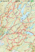
A small section of the trail map showing just how jam packed this place is with trails. I suppose this is because we just don’t have as much wilderness in the NYC area.
I started at the Elk Pen parking lot where the AT enters Harriman and works its way north. AT thru-hikers hiking SOBO usually arrive in June, NOBO hikers arrive in July, and flip floppers (those who switch from NOBO to SOBO by flying from Damascus VA to Maine) arrive throughout August, so there are only day hikers and weekenders on the trails in October unless you get on the Long Path (the LP is a 356 mile trail that goes from the NJ side of the George Washington Bridge to Thatcher State Park near Albany).
There are 12 shelters in Harriman State Park. They are rustic stone and wood lean-to’s that were built in the 1920’s, right around the time the AT was constructed. My plan was to hike 13 miles from my car to the West Mountain Shelter on Saturday. Sunday morning I would have a short 3.5 mile hike to another parking lot where my wife would pick me up and shuttle me back to my car. The West Mountain Shelter is my favorite shelter in Harrimian because it overlooks the Hudson River and the NYC skyline can be seen right from the shelter platform. It’s also only 0.6 miles off of the AT.
When I got to the West Mountain Shelter, I met a young couple around the same age as myself who had set their tent up on one side of the shelter platform. I thought about setting my tent up somewhere else in the vicinity, but they were really friendly and down to earth and insisted they preferred company to privacy, so I ended up setting my tent up on the other side of the shelter platform. We were joined by another hiker who was a 2011 AT thru-hiker and 2012 PCT thru-hiker. He set his tent up behind the shelter but the four of us hung out for a few hours while we cooked dinner and watched the NYC skyline light up as the sun went down. They were awesome company and we had some great conversation until we all decided to hit the hay and call it a night.
It was a short 3.5 mile hike the next morning to the parking lot where we were all ending our trips so we all hiked together. We arrived at the parking lot around 10 a.m. and said our goodbyes. A few minutes later, my wife arrived to pick me up and shuttle me back to my car at Elk Pen. I was home on the couch ready to watch football before the games even started.
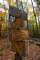
The intersection of the Appalachian Trail and the Long Path. According to the signs I was standing on the AT 793 miles from the northern terminus (Mount Katahdin, ME) and 1,365 miles from the southern terminus (Springer Mountain, GA)
As everyone probably knows, to hike the AT, you simply follow the white blazes. Some shots with the standard white AT blaze.


Some of the lakes of Harriman State Park


From Black Mountain you get a view of the NYC skyline

The West Mountain Shelter is 0.6 miles off of the AT on the Timp Torne Trail which goes along the ridge of West Mountain.


Finally arriving at the West Mountain Shelter
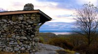
From the shelter you can see the Hudson River and the NYC skyline off to the right
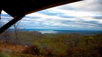
The NYC skyline on the right of the horizon


I tried to get up early to catch the sun rise but I sort of missed it. But this is what I got.

In the morning I hiked with the 3 others I had met at the Shelter.

We were looking at Bear Mountain... You can see Perkins Tower atop Bear Mountain on the left of the picture.

When my wife picked me up, we took a nice scenic ride down Seven Lakes Drive back to my car

Sometimes it's just nice to get out for a quick overnighter even if you don't bother going too far.
Featured image for home page:

10/18/2014
I debated whether to post this since most TR’s on here are epic and this one certainly is not. I live about 20 minutes from Harriman State Park in NY and consider it my “backyard” for hiking. Roughly 19 miles of the Appalachian Trail traverses through the Park. This past Saturday (10/18/14) my wife had her girlfriends over so that was my cue to pack up the overnight bag and slip out the back door. I decided to do 16 of the 19 miles of the AT that runs through the Park with an overnight at the West Mountain Shelter.
Harriman in a nutshell:
Where is it? 30 miles north of New York City
How big is it? Approx. 47 thousand acres
What’s there? An intricate trail system consisting of over 200 miles of trails. There are also 31 lakes, a public camping area, and a dozen rustic first-come first-serve shelters.
A small section of the trail map showing just how jam packed this place is with trails. I suppose this is because we just don’t have as much wilderness in the NYC area.

I started at the Elk Pen parking lot where the AT enters Harriman and works its way north. AT thru-hikers hiking SOBO usually arrive in June, NOBO hikers arrive in July, and flip floppers (those who switch from NOBO to SOBO by flying from Damascus VA to Maine) arrive throughout August, so there are only day hikers and weekenders on the trails in October unless you get on the Long Path (the LP is a 356 mile trail that goes from the NJ side of the George Washington Bridge to Thatcher State Park near Albany).
There are 12 shelters in Harriman State Park. They are rustic stone and wood lean-to’s that were built in the 1920’s, right around the time the AT was constructed. My plan was to hike 13 miles from my car to the West Mountain Shelter on Saturday. Sunday morning I would have a short 3.5 mile hike to another parking lot where my wife would pick me up and shuttle me back to my car. The West Mountain Shelter is my favorite shelter in Harrimian because it overlooks the Hudson River and the NYC skyline can be seen right from the shelter platform. It’s also only 0.6 miles off of the AT.
When I got to the West Mountain Shelter, I met a young couple around the same age as myself who had set their tent up on one side of the shelter platform. I thought about setting my tent up somewhere else in the vicinity, but they were really friendly and down to earth and insisted they preferred company to privacy, so I ended up setting my tent up on the other side of the shelter platform. We were joined by another hiker who was a 2011 AT thru-hiker and 2012 PCT thru-hiker. He set his tent up behind the shelter but the four of us hung out for a few hours while we cooked dinner and watched the NYC skyline light up as the sun went down. They were awesome company and we had some great conversation until we all decided to hit the hay and call it a night.
It was a short 3.5 mile hike the next morning to the parking lot where we were all ending our trips so we all hiked together. We arrived at the parking lot around 10 a.m. and said our goodbyes. A few minutes later, my wife arrived to pick me up and shuttle me back to my car at Elk Pen. I was home on the couch ready to watch football before the games even started.
The intersection of the Appalachian Trail and the Long Path. According to the signs I was standing on the AT 793 miles from the northern terminus (Mount Katahdin, ME) and 1,365 miles from the southern terminus (Springer Mountain, GA)

As everyone probably knows, to hike the AT, you simply follow the white blazes. Some shots with the standard white AT blaze.


Some of the lakes of Harriman State Park


From Black Mountain you get a view of the NYC skyline

The West Mountain Shelter is 0.6 miles off of the AT on the Timp Torne Trail which goes along the ridge of West Mountain.


Finally arriving at the West Mountain Shelter

From the shelter you can see the Hudson River and the NYC skyline off to the right

The NYC skyline on the right of the horizon


I tried to get up early to catch the sun rise but I sort of missed it. But this is what I got.

In the morning I hiked with the 3 others I had met at the Shelter.

We were looking at Bear Mountain... You can see Perkins Tower atop Bear Mountain on the left of the picture.

When my wife picked me up, we took a nice scenic ride down Seven Lakes Drive back to my car

Sometimes it's just nice to get out for a quick overnighter even if you don't bother going too far.
Featured image for home page:

Last edited:
