fossana
Member
- Joined
- Jan 11, 2018
- Messages
- 1,081

Intro
Recovering from gluteus medius tendonopathy, the last few months have been a bit rough. I even passed on a Sierra trip, since steep uphills wreaked havoc on my hip. With temps surpassing 100 F in town, I decided to test things out again in the Tushars and invited my neighbors along.
We headed up to Big John Flat the night before, and passed numerous sites occupied by people who annoyingly left their unoccupied RVs, and sometimes ATVs, likely for extended periods despite the 16-day limit. We found a quiet spot to pitch our tents, threw sticks for border collie Aeden, then settled in for the night.
Logistics
Jurisdiction: Fishlake National Forest
Permits: none required
Dogs friendly: yes
Water: many streams along the way, possible snow fields
Start/end: Recommend Skyline trail crossing at Big John Flat. Some of the other trailheads have less reliable road access.
Mileage: ~11.1 miles
Elevation gain: ~4200 ft
Navigation: For the most part the trail and most junctions were signed; however the trail was inapparent at times during the high meadow crossings.
The Route (Caltopo link)
Our plan was to hike the Skyline Trail (225) to 219, then either continue over the Alunite Saddle to the northern approach to Delano Peak (072 to 224) or find a cross-country route up Delano from east.


Photos
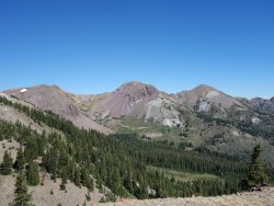
We hiked the rolling terrain through trees and wildflower-filled meadows. The larkspur (Delphium sp.) and elephant head orchids (Pedicularis groenlandica) were particularly striking We turned north onto 219 and climbed to the saddle to the west of Mt Holly. I felt surprisingly good above 10K ft despite only a handful of higher altitude hikes in the Pine Valleys this season.


At the Mt Holly saddle we stopped for snacks and surveyed our options. The shallow drainage I had originally scoped out on the map had a nasty appearing scree slope near the top. We decided to scope things out further after we dropped into the valley. The flower-filled valley below the craggy NE face of Mt Holly was as spectacular as always.


The gentle ridge of the unnamed 12K ft peak just to the east of Delano Peak looked inviting. From the valley it looked like we would be able to cut north near the top to join the summit plateau. We left the trail and headed up the talus slopes, doing our best to avoid the thorny current bushes. I walked ahead to scope out our route. The further right I traversed, the more loose the scree. I called down to my neighbors to head straight up the headwall, which looked likely 3rd class.
As I topped out on the short headwall I saw an easy, but exposed ridge traverse. Fun in my book, but maybe not so much for my more risk adverse companions. As I waited for my neighbors to catch up, the winds picked up and the thunder started; the forecast had said 0% chance of precipitation. Several times the wind gusts caused me and Aeden to stumble. My neighbor asked me to talk her through the traverse (she did great in the end). The routefinding was relatively straightforward with only one gendarme bypass.


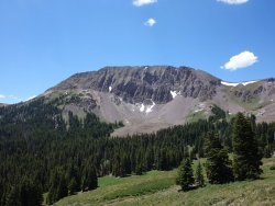
Finally we topped out on the grassy summit plateau and took a quick snack break. All that was left was the final 400' push to the top of Delano Peak. We checked out the mountain goat herds from a distance as we made our way up. The wind was blowing so hard on the summit that we could barely hear each other. As we heading down, we were hit with short bursts of giant rain drops and hail. Luckily we knew we only had only ~2 miles to go. When we hit the trailhead I walked ahead to retrieve the car, and we headed home tired but happy.


Attachments
Last edited:
")