Navigation
Install the app
How to install the app on iOS
Follow along with the video below to see how to install our site as a web app on your home screen.
Note: This feature may not be available in some browsers.
More options
You are using an out of date browser. It may not display this or other websites correctly.
You should upgrade or use an alternative browser.
You should upgrade or use an alternative browser.
Survivorman in Utah
- Thread starter Aldaron
- Start date
Aldaron
Member
- Joined
- Jun 16, 2012
- Messages
- 1,487
I'm watching the episode right now with all of the pictures we took this weekend, and I think I've about got it pieced together. I'll post the pictures and screen shots in a minute...but I'm afraid my conclusions are going to hurt your opinion of Les.
Aldaron
Member
- Joined
- Jun 16, 2012
- Messages
- 1,487
Alright, I think I'm ready to make my case. After thinking about it, I'm not quite as disappointed in him as I initially was, but my conclusions are still surprising to me.
So here's what I've got:
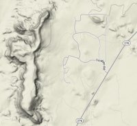
This is a screen shot from them flying over a town. I'm confident this is Ticaboo. @Nick, I'm sure @audraiam can confirm that. See my satellite picture below of Ticaboo for comparison.
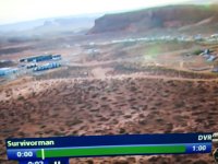
You can see a row of three long buildings in the picture above and the satellite view, as well as the row of houses to the west of the 3 buildings.
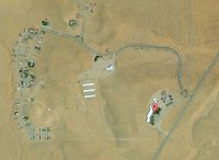
And west of the row of houses, you can see the butte on the map below that is beside the houses in the screen shot.
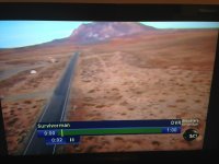
Next, is a screen shot from the helicopter. The gravel driveway in the foreground is the entrance to Ticaboo Lodge, the road is Hwy 276, and the mountain is Mt Ellsworth.
Here's a Google Street shot of the same view right outside the Ticaboo Lodge. Notice the yellow road sign in the screen shot above and on the Google view.
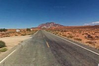
So, I think we can reliably conclude they are in the Ticaboo area.
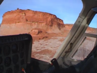
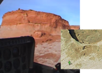
Next, we have the place where the helicopter landed at the beginning of the show:
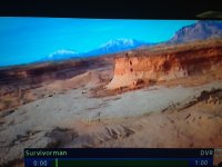
Now, this is the one shot from the whole show that I'm not completely confident about, but I think it's taken from the east side of Smith Fork. If you'll notice the perspective of the mountains and then look at the map below, you'll see why I think that.
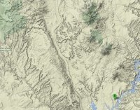
The "B" marks the area where I think they landed. From there, you would see Ellsworth in the foreground, and then Hillers and Pennell in the background. You can't see the South Summit Ridge further north from Pennell, because from this angle it would be completely behind Pennell. And when we were there this weekend, Hillers and Pennell had snow on them, but the south side of Ellsworth didn't have any snow on it. This matches what we see in the screen shot above. Additionally, the east side of Smith Fork has lots of slickrock which matches the slickrock he rode his bike on.
So, I think he landed the helicopter and rode his bike on the slickrock around Smith Fork. And if you look at the coordinatesI've marked for Smith Fork, there's a butte right in the middle of the slickrock that closely matches the butte in the screen shot. I can't swear it's the same place, though, but it fits my interpretation of the map.
But this is where it gets weird. Remember, based on my conclusion, he landed south of Ellsworth. After landing, he rides around on a bike. Then he starts "surviving."
Here is a screen shot from his first day:
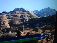
You can see him in the foreground, so you know this isn't a "stock" shot. But notice the mountain in the background. Look familiar?
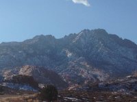
That's right, it's the north side of Mt Holmes. Notice the profile of the mountain top peaks, and you can see it's the same mountain.
Obviously, my picture from this weekend isn't from exactly the same spot, but it's pretty close. And it's definitely close enough to confidently conclude that he's on the north side of Holmes.
Now, of course, up to this point, it's possible that I'm wrong about where he landed, and he actually landed north of the Little Rockies rather than south of the Little Rockies. I'm not totally confident that he landed south of the Little Rockies, but I am totally confident that he spent his first couple of days north of the Little Rockies.
So, he's north of Mt Holmes the first couple of days. But this is where it gets really weird. On his second day he complains that he can't find any water at his campsite so he's going to have to move and look for water. And this is the next shot we get after he has walked off:
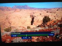
Well, I took the next two pictures from near Ticaboo Shelf Spring on the south side of the Little Rockies just below Ellsworth:
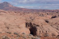
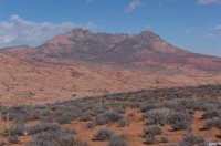
Again, compare the mountain profile from the screen shot with the mountain profile in my second picture. My second picture is Mt Holmes again...but this one is from the south side. I am completely confident that we are looking at Mt Holmes from its SOUTH side, and I am completely confident that the day before we were looking at Mt Holmes from its NORTH side. In fact, I am completely confident that he took this video from the top of Ticaboo Shelf Spring at the CCC cow trail that drops down into a fork of the South Fork Ticaboo Creek.
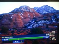
And here's the real kicker that seals the deal for me:
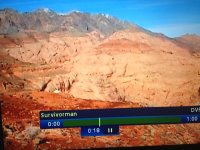
It's not easy to see, but do you see the white spot just above where it says Survivorman?
I believe that is this:
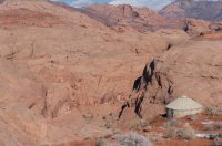
The water tank at the spring. This tank is a little down hill from the desert floor. And from east of the tank, this is the view of Mt Ellsworth that you have:
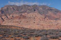
Compare the profile of the mountain from the screen shot and the profile of the mountain in my picture. Do you see the same Mt Ellsworth view from the screen shot? The water tank is just out of view in my picture.
From here, it appears to me that he drops down into South Fork Ticaboo Creek from the cow trail at the tank and continues into the canyon.
And that's it.
So, here is my theory:
The video of him riding the bike is not actually where he was dropped off. They just filmed him riding his bike on the slickrock above Smith Fork. From there, he went to the north side of Mt Holmes...and not very far from the highway at all...and tried to do his show. But after two days he realized that his show was about to be cut very short because he couldn't find water and couldn't get down into the canyons...and I think the canyon was Swett. So he got picked up and moved back to the south side of the Little Rockies where they knew he could find a way down into the canyons, and they dropped him off near the water tank at Ticaboo Shelf Spring and pointed him towards the cow trail that was built by the CCC. From there he dropped down into the canyon and did the rest of his show.
So, what do you think? Poke holes in the theory! Help me figure it out!
And if my conclusions are right, does this affect your view of the show?
And while you're thinking I'm crazy for going to all this trouble, remember that it was your tax money that turned me into this!
So here's what I've got:
This is a screen shot from them flying over a town. I'm confident this is Ticaboo. @Nick, I'm sure @audraiam can confirm that. See my satellite picture below of Ticaboo for comparison.

You can see a row of three long buildings in the picture above and the satellite view, as well as the row of houses to the west of the 3 buildings.

And west of the row of houses, you can see the butte on the map below that is beside the houses in the screen shot.

Next, is a screen shot from the helicopter. The gravel driveway in the foreground is the entrance to Ticaboo Lodge, the road is Hwy 276, and the mountain is Mt Ellsworth.

Here's a Google Street shot of the same view right outside the Ticaboo Lodge. Notice the yellow road sign in the screen shot above and on the Google view.

So, I think we can reliably conclude they are in the Ticaboo area.
Next, we have the place where the helicopter landed at the beginning of the show:

Now, this is the one shot from the whole show that I'm not completely confident about, but I think it's taken from the east side of Smith Fork. If you'll notice the perspective of the mountains and then look at the map below, you'll see why I think that.

The "B" marks the area where I think they landed. From there, you would see Ellsworth in the foreground, and then Hillers and Pennell in the background. You can't see the South Summit Ridge further north from Pennell, because from this angle it would be completely behind Pennell. And when we were there this weekend, Hillers and Pennell had snow on them, but the south side of Ellsworth didn't have any snow on it. This matches what we see in the screen shot above. Additionally, the east side of Smith Fork has lots of slickrock which matches the slickrock he rode his bike on.
So, I think he landed the helicopter and rode his bike on the slickrock around Smith Fork. And if you look at the coordinatesI've marked for Smith Fork, there's a butte right in the middle of the slickrock that closely matches the butte in the screen shot. I can't swear it's the same place, though, but it fits my interpretation of the map.
But this is where it gets weird. Remember, based on my conclusion, he landed south of Ellsworth. After landing, he rides around on a bike. Then he starts "surviving."
Here is a screen shot from his first day:

You can see him in the foreground, so you know this isn't a "stock" shot. But notice the mountain in the background. Look familiar?

That's right, it's the north side of Mt Holmes. Notice the profile of the mountain top peaks, and you can see it's the same mountain.
Obviously, my picture from this weekend isn't from exactly the same spot, but it's pretty close. And it's definitely close enough to confidently conclude that he's on the north side of Holmes.
Now, of course, up to this point, it's possible that I'm wrong about where he landed, and he actually landed north of the Little Rockies rather than south of the Little Rockies. I'm not totally confident that he landed south of the Little Rockies, but I am totally confident that he spent his first couple of days north of the Little Rockies.
So, he's north of Mt Holmes the first couple of days. But this is where it gets really weird. On his second day he complains that he can't find any water at his campsite so he's going to have to move and look for water. And this is the next shot we get after he has walked off:

Well, I took the next two pictures from near Ticaboo Shelf Spring on the south side of the Little Rockies just below Ellsworth:


Again, compare the mountain profile from the screen shot with the mountain profile in my second picture. My second picture is Mt Holmes again...but this one is from the south side. I am completely confident that we are looking at Mt Holmes from its SOUTH side, and I am completely confident that the day before we were looking at Mt Holmes from its NORTH side. In fact, I am completely confident that he took this video from the top of Ticaboo Shelf Spring at the CCC cow trail that drops down into a fork of the South Fork Ticaboo Creek.
And here's the real kicker that seals the deal for me:

It's not easy to see, but do you see the white spot just above where it says Survivorman?
I believe that is this:

The water tank at the spring. This tank is a little down hill from the desert floor. And from east of the tank, this is the view of Mt Ellsworth that you have:

Compare the profile of the mountain from the screen shot and the profile of the mountain in my picture. Do you see the same Mt Ellsworth view from the screen shot? The water tank is just out of view in my picture.
From here, it appears to me that he drops down into South Fork Ticaboo Creek from the cow trail at the tank and continues into the canyon.
And that's it.
So, here is my theory:
The video of him riding the bike is not actually where he was dropped off. They just filmed him riding his bike on the slickrock above Smith Fork. From there, he went to the north side of Mt Holmes...and not very far from the highway at all...and tried to do his show. But after two days he realized that his show was about to be cut very short because he couldn't find water and couldn't get down into the canyons...and I think the canyon was Swett. So he got picked up and moved back to the south side of the Little Rockies where they knew he could find a way down into the canyons, and they dropped him off near the water tank at Ticaboo Shelf Spring and pointed him towards the cow trail that was built by the CCC. From there he dropped down into the canyon and did the rest of his show.
So, what do you think? Poke holes in the theory! Help me figure it out!
And if my conclusions are right, does this affect your view of the show?
And while you're thinking I'm crazy for going to all this trouble, remember that it was your tax money that turned me into this!
- Joined
- Aug 9, 2007
- Messages
- 12,950
First thought - I think you are right to not be sure of the coords of where the helicopter landed. The sandstone isn't the right color or texture there. I think they landed here:
37.616615,-110.64164
37.616615,-110.64164
Aldaron
Member
- Joined
- Jun 16, 2012
- Messages
- 1,487
Yeah, you might be right...I wasn't sure if the butte was a stand-alone or if it were attached to the desert floor. I did believe that they were near the desert floor, though, so your actual coordinates are more likely to be right. But that's still at Smith Fork.
- Joined
- Aug 9, 2007
- Messages
- 12,950
So I just started watching and I grabbed a screen shot that makes me 100% positive that we are right on the helicopter landing at 37.616615,-110.64164.
The quality sucks because I'm using Netflix, but check out this shot from the helicopter as they show Les riding his bike away, heading east. It's easy to match up the exact same features on the slickrock in the helicopter shot and the sat view. Probably easier to click the coords above and compare up close, but the darker soil on the lighter slickrock matches up perfectly in many spots. That little blur in the middle of the shot is Les riding the bike away.
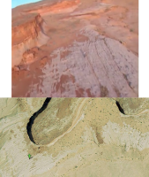
Okay, now I go back and keep watching. This is fun.
The quality sucks because I'm using Netflix, but check out this shot from the helicopter as they show Les riding his bike away, heading east. It's easy to match up the exact same features on the slickrock in the helicopter shot and the sat view. Probably easier to click the coords above and compare up close, but the darker soil on the lighter slickrock matches up perfectly in many spots. That little blur in the middle of the shot is Les riding the bike away.

Okay, now I go back and keep watching. This is fun.
- Joined
- Aug 9, 2007
- Messages
- 12,950
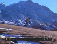
So I just watched the biking scene after the helicopter drop off and noticed those clips were taken from all over the place. Lots of aerial shots from the helicopter near the obvious drop off point, but lots of shots from who knows where and one very brief, but very interesting shot on the north side of Holmes. Hahaha!

Aldaron
Member
- Joined
- Jun 16, 2012
- Messages
- 1,487
Yeah, that dark spot directly in front of Les on the screen shot matches a spot to the right of the marker on your sat view. I think you nailed it.
Next, you need to find the rock dome where he was camped on night one that was north of Holmes somewhere around Swett Canyon.
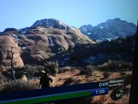
My wife has turned it into a competition and wants to figure it out first!
Next, you need to find the rock dome where he was camped on night one that was north of Holmes somewhere around Swett Canyon.


My wife has turned it into a competition and wants to figure it out first!
Aldaron
Member
- Joined
- Jun 16, 2012
- Messages
- 1,487
So I just watched the biking scene after the helicopter drop off and noticed those clips were taken from all over the place. Lots of aerial shots from the helicopter near the obvious drop off point, but lots of shots from who knows where and one very brief, but very interesting shot on the north side of Holmes. Hahaha!
Yeah, I noticed that, too.
- Joined
- Aug 9, 2007
- Messages
- 12,950
Okay, so just watched through that again. My thoughts:
You nailed it. The helicopter ride was definitely just for some fancy footage and nothing to do with his hike. Definitely on the north side of Holmes by Swett Creek the first two nights and definitely the south side afterward. Definitely would have needed a lift to get down there and it appears it was still quite early in the day. Very disappointing, Mr. Stroud.
So long as I'm feeling dissapointed, let's pick a few other things apart in that video...
Since when does the temp range fluctuate between 57 and 12 degrees each day down there?! Those are the actual temps they listed.
Snow all around his first campsite but has to leave for lack of water?
At the first site, which we can safely say can't be more than a mile or two from the road (maybe even less than a mile), Les says "The crew will have to fly in later to cleanup the site". SERIOUSLY, LES!??!
On the descent from Ticaboo Shelf Spring which was clearly on a well-worn cattle trail, he's talking about how it is AT LEAST 1,000 feet down. I understand that many of us tend to exaggerate heights at times, I am not innocent of this. But after the climb, they toss some text up that says "1500 Vertical Feet Drop". What the hell is that about?! I kind of understand the helicopter/bike drop off lie. I can even maybe sort of understand filming the show a few hundred yards from the highway. Okay, maybe not. But there's something about going back to the studio, 'verifying data', and then putting such an complete lie up on the screen in text. There is no canyon with a 1500 foot descent out there! Looks closer to 500 feet to me. How disappointing....
Now with that said, I'd like to go find both of his campsites. When are we going? I'll post my speculation and opinion on your guess on the first site in a bit, but I don't think you're far off.
Similar threads
Similar threads
-
-
-
-
-
-
-
-
-
Invite Looking for shuttle partner -- two trips in Southern Utah
- Started by Normie
- Replies: 5
-
Identify the spot Utah: I don't know where it is
- Started by James and Amy
- Replies: 2
-
Oh look yet another Utah conditions thread: mid May 2023
- Started by BeardoMcGrath
- Replies: 9
-
-
-
-
-
-
Grand Gulch Cedar Mesa Utah 11 Day Backpack October 2022
- Started by canyonman342
- Replies: 10
-
-
four day backpacking trip in southern Utah starting this weekend
- Started by vrak
- Replies: 4
-
-
"I Would Walk 500 Miles ..." - A Utah Adventure - April 2022 - Final Part
- Started by TrailScot
- Replies: 11
-
"I Would Walk 500 Miles ..." - A Utah Adventure - April 2022 - Part 5
- Started by TrailScot
- Replies: 3
-
"I Would Walk 500 Miles ..." - A Utah Adventure - April 2022 - Part 4
- Started by TrailScot
- Replies: 10
-
"I Would Walk 500 Miles ..." - A Utah Adventure - April 2022 - Part 3
- Started by TrailScot
- Replies: 4
-
"I Would Walk 500 Miles ..." - A Utah Adventure - April 2022 - Part 2
- Started by TrailScot
- Replies: 5
-
"I Would Walk 500 Miles ..." - A Utah Adventure - April 2022 - Part 1
- Started by TrailScot
- Replies: 6
-
-
-
Dripping Canyon to Grand Gulch, Cedar Mesa, Utah - March 2022
- Started by TrailScot
- Replies: 7
-
-
-
-
-
-
-
-
-
-
-
-
-
-
Newbie Overnight with REI gear - Farmington, Utah May 2021
- Started by GramaNana
- Replies: 12
-
-
-
-
-
-
-

