Incredible Coyote Gulch trip! We are so appreciative of all the info and advice we received here and through other sources online. I won't detail all of our trip, as there are many reports elsewhere about the outstanding scenery in Coyote Gulch, but I wanted to share some special things that made this such a wonderful experience.
We flew into Vegas. I always try to get a window seat and love looking down when the clouds aren't too thick. When we were getting near Utah, I kept track of where we were and was thrilled to see Coyote Gulch and the Escalante River below.


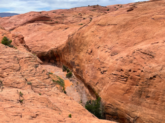
We spent the night in St. George, then drove to our trailhead the next day. Since we had a full week for our trip, we wanted to stretch things out and decided to enter and exit via Red Well. We loved this and thought it worked great! The scenery was interesting right away, it wasn't too brushy, and we saw no one the whole day. We checked out the entrance to Sleepy Hollow, which we hoped to be able to explore near the end of the week... We camped the first night at a wonderful campsite at the confluence of Coyote Gulch and Hurricane Wash, and with perfect weather we didn't bother putting up our tent. The bright moon (almost full on April 21) lit up not only the rock walls but also the shiny cottonwood leaves. This was my view while falling asleep:

The next day was terrific - we thoroughly enjoyed all the fabulous things that make Coyote Gulch such a desirable trip, but I'm not going to bother sharing photos in this report: Jacob Hamlin Arch, a zillion alcoves, Coyote/Natural Bridge, petroglyphs and Native remains, waterfalls, etc etc etc. The mix of green, orange, and blue repeating over and over again was gorgeous, and I took a million reflection shots with glowing green leaves, orange rock, and blue sky. We saw our first cactus bloom, which always delights me. We made our way past the poison ivy up to the Black Lagoon, and I captured this reflection there:

Most of the lizards darted away when I tried to photograph them. Not this one!

We thoroughly enjoyed that full day. We saw some people along the way but not too many to diminish our enjoyment. We set up camp for two nights at a wonderful spot a little bit upstream from the confluence with the Escalante; thank you for the info, @TrailScot! Here's a view of Stevens Arch from behind our campsite:

That evening, we had time to explore and went up the trail behind the campsite to the fantastic promontory across from Stevens Arch that @Jammer describes in his acrossutah website. We loved being up there and had a great time not only viewing the arch (would we make it there the next day???) but also checking out lots of things down below where we might be the next day... Here's one of my photos from up there with the glowing golden light:

The next day, we took small day packs and set out for some adventure, unsure of what we'd be able to manage but hopeful. We had an incredible day! First, we went up to the Crack in the Wall. (Along the way, we saw some people on the "slanted sketchy ledge" that can be used to get to the Escalante; my husband did not like the looks of that at all.) We had fun in the crack and didn't have to worry about using a rope since our packs were small. At the top, we spent almost an hour wandering around on the glorious slickrock and looking down on the Escalante. It was fun to see different bends in the river and a different view of Stevens Arch from what we had seen at our campsite and from the Crack in the Wall route:


Navajo Mtn off in the distance

Then we went back down Crack in the Wall (fun to do it both ways!) and instead of returning the way we came, we used the trail that @desertvic had told me about (thank you!) and enjoyed new scenery along the way. We were able to go down the "steep descent" (again, thanks for the info @desertvic and @Jammer) and found that a little intimidating but definitely do-able. Here are pictures going down and looking back up afterward:


By the way, here's a close-up of what that descent looks like from across the way - taken the previous evening when we were on the promontory:

We helped each other get down to Coyote Gulch via a sandy mini-cliff that was a bit too long for us to comfortably slide down:


Then we were down at the gulch, having bypassed the rock jumble and "slanted sketchy ledge." I was thrilled to get to the river! Now would we be able to accomplish the next goal of getting up to Stevens Arch?
I'm happy to say that YES, we did! @Jammer's wonderful acrossutah descriptions gave us the inspiration and information to get there. It is terrific! The previous evening, we had seen from the promontory the spot where you go up, and my husband assumed it wouldn't be possible for us to make it:

But Jamal is correct when he says it's doable. Hooray!


We went through the arch and down the other side for a little while. Here's a picture of the arch from that side: (Is it possible that the plane was on the same route that my plane was on a few days earlier?)

We saw a little bit of Stevens Canyon from the top:

Then we made our way back through the arch and down the way we had come. We got down to the river and were happy to cool off on this hot day. We walked upstream, not sure if we'd go as far as Stevens Canyon. Along the way, I took a zillion photos of the beautiful scenery. One of the times I turned around and looked behind me I was rewarded with this incredible reflection that I would have missed if I had turned around a moment earlier or later:

We ended up going to Stevens Canyon and enjoyed chatting with some packrafters who were also heading up there. We had set for ourselves a turn-around time of 5:30pm so didn't make it up to the Grotto but were glad to get into the canyon a little bit and see Stevens Arch from yet another vantage point. (Yes, Stevens Arch was our fixation for the day - so magical!)

After Stevens, we decided to try getting back to our campsite via the other part of the alternate route, exiting the river a little bit downstream of Stevens and going up from there to the promontory and then following the route from the previous evening back to our campsite. There were a few sketchy spots, including one where my husband made some rocks tumble below (thank goodness I was above him at that point), but we made it. Yet another view of the arch!

Both nights at that campsite we slept under the stars (well, under the full moon is more accurate) and were serenaded by sheep frogs for hours. Perfect!
The next day, we headed back up Coyote Gulch. Typically, we prefer a loop to an out-and-back, but when the scenery is this outstanding who minds seeing it twice? Plus, you see things differently. For example, our view of Cliff Arch in this direction made us think it should be called Monster Arch:

Early in the week, there was almost no cottonwood fluff. By this point, though, we enjoyed lots of flying fluff, something I had wanted to see on a previous Escalante trip but was too early for. The fluff looked great when it was backlit by the sun, but I couldn't get good photos of that. Here are some other pictures of the fluff:


It was a hot day. Over and over we dunked in the water or took off our shirts, wet them, and put them back on so we could stay cool while hiking. Such an easy way to cool down! Here's my husband at Swiss Cheese Falls:

Our original hope for this evening was to camp in Sleepy Hollow under one of the giant alcoves there. However, we talked to a few people who knew Coyote Gulch well and the previous day had tried to get up Sleepy Hollow to the alcoves. They said it was slow going with lots of poison ivy, cattails, and thick brush. We decided that instead of trying to get up there with heavy packs late in the day we would camp nearby and attempt it with small packs the next day. We found a wonderful campsite and headed to Sleepy Hollow the next morning. Fortunately it was a cool, overcast day, so I wore my rainpants to reduce poison ivy exposure and my jacket to minimize scratches from the bushes. We didn't know what to expect and figured we'd give it our best shot. We ended up having a glorious day! We made our way through the thick brush and eventually got up to the giant alcove on the right (going up canyon). It was spectacular! Then we went to the other giant alcove across the way. It was spectacular, too!
Going to the top of the big sand hill inside the first alcove

Looking down from the sand hill inside the alcove

View from inside first alcove

If you're not flexible, you can get a neck-ache trying to see the top here and throughout Coyote Gulch!

Going up the sand dune inside the second alcove


View from inside second alcove - elephant head?

Going back down sand dune in second alcove

After exploring a bit, we headed back the way we came and thrashed through the reeds, cattails, and other brush. Earlier, on the way in, we had noticed some slickrock up above that would be fun to explore if we could get up there. By this point, I had forgotten all about that, but my husband had not.

Hmm... how can we get up? Ah, look at that those logs...

Let's do it!

Success! We explored up there for hours. Let's go look at Sleepy Hollow from above. Ok! Let's go look at Coyote Gulch from above. Ok! Let's go look at Long Branch from above. Ok! Let's go look at Don't Do It slot canyon from above. Ok! Let's go look at these fabulous rocks. Ok! And on and on. Lots of beautiful cacti and other great stuff to look at up there. We couldn't get far enough up Sleepy Hollow to see the giant alcoves from above because Long Branch was in the way, but that was ok. Sometimes the clouds were tinged orange from the rock below, and sometimes there were interesting threatening clouds off in the distance. We had a couple of sprinkles here and there but nothing bad. We had a great time - this was a totally unexpected delight!


It was fun to see where our campsite was - behind that tall rock (or whatever you call such a thing)

The next day we headed back to the trailhead, sad to be finishing but thrilled with the wonderful trip. We had fun doing things differently from our way in, often going up above the gulch rather than alongside it. At one point, we took a cut-off we shouldn't have taken which led us to go up Dry Fork a bit. Before we realized this, I was fascinated to see this dead tree up on the slickrock. What a big flash flood there must have been to bring that tree up so high and deposit it there.

On our way back to the trailhead, we had originally hoped to drive down the road a few miles and have fun at Spooky/Peekaboo/Brimstone. But there were dark clouds and rainstorms off in the distance, so we knew there would be no slot canyons for us that day.

Instead we went to Escalante Outfitters for some pizza.")
On our way to St. George, we made an impromptu visit to Bryce, first to the Mossy Cave trailhead and then around to the main entrance for a quickie at that glorious amphitheater. The brooding skies made for a great backdrop!


The next morning we had hoped to explore Yant Flat / Candy Cliffs, but we got in so late the night before that we slept in and didn't have time before driving back for our flight. We had such a perfect week! Thanks again to those who provided us with such great information - you helped make our experience the best it possibly could be!
We flew into Vegas. I always try to get a window seat and love looking down when the clouds aren't too thick. When we were getting near Utah, I kept track of where we were and was thrilled to see Coyote Gulch and the Escalante River below.
We spent the night in St. George, then drove to our trailhead the next day. Since we had a full week for our trip, we wanted to stretch things out and decided to enter and exit via Red Well. We loved this and thought it worked great! The scenery was interesting right away, it wasn't too brushy, and we saw no one the whole day. We checked out the entrance to Sleepy Hollow, which we hoped to be able to explore near the end of the week... We camped the first night at a wonderful campsite at the confluence of Coyote Gulch and Hurricane Wash, and with perfect weather we didn't bother putting up our tent. The bright moon (almost full on April 21) lit up not only the rock walls but also the shiny cottonwood leaves. This was my view while falling asleep:
The next day was terrific - we thoroughly enjoyed all the fabulous things that make Coyote Gulch such a desirable trip, but I'm not going to bother sharing photos in this report: Jacob Hamlin Arch, a zillion alcoves, Coyote/Natural Bridge, petroglyphs and Native remains, waterfalls, etc etc etc. The mix of green, orange, and blue repeating over and over again was gorgeous, and I took a million reflection shots with glowing green leaves, orange rock, and blue sky. We saw our first cactus bloom, which always delights me. We made our way past the poison ivy up to the Black Lagoon, and I captured this reflection there:
Most of the lizards darted away when I tried to photograph them. Not this one!
We thoroughly enjoyed that full day. We saw some people along the way but not too many to diminish our enjoyment. We set up camp for two nights at a wonderful spot a little bit upstream from the confluence with the Escalante; thank you for the info, @TrailScot! Here's a view of Stevens Arch from behind our campsite:
That evening, we had time to explore and went up the trail behind the campsite to the fantastic promontory across from Stevens Arch that @Jammer describes in his acrossutah website. We loved being up there and had a great time not only viewing the arch (would we make it there the next day???) but also checking out lots of things down below where we might be the next day... Here's one of my photos from up there with the glowing golden light:
The next day, we took small day packs and set out for some adventure, unsure of what we'd be able to manage but hopeful. We had an incredible day! First, we went up to the Crack in the Wall. (Along the way, we saw some people on the "slanted sketchy ledge" that can be used to get to the Escalante; my husband did not like the looks of that at all.) We had fun in the crack and didn't have to worry about using a rope since our packs were small. At the top, we spent almost an hour wandering around on the glorious slickrock and looking down on the Escalante. It was fun to see different bends in the river and a different view of Stevens Arch from what we had seen at our campsite and from the Crack in the Wall route:
Navajo Mtn off in the distance
Then we went back down Crack in the Wall (fun to do it both ways!) and instead of returning the way we came, we used the trail that @desertvic had told me about (thank you!) and enjoyed new scenery along the way. We were able to go down the "steep descent" (again, thanks for the info @desertvic and @Jammer) and found that a little intimidating but definitely do-able. Here are pictures going down and looking back up afterward:
By the way, here's a close-up of what that descent looks like from across the way - taken the previous evening when we were on the promontory:
We helped each other get down to Coyote Gulch via a sandy mini-cliff that was a bit too long for us to comfortably slide down:
Then we were down at the gulch, having bypassed the rock jumble and "slanted sketchy ledge." I was thrilled to get to the river! Now would we be able to accomplish the next goal of getting up to Stevens Arch?
I'm happy to say that YES, we did! @Jammer's wonderful acrossutah descriptions gave us the inspiration and information to get there. It is terrific! The previous evening, we had seen from the promontory the spot where you go up, and my husband assumed it wouldn't be possible for us to make it:
But Jamal is correct when he says it's doable. Hooray!
We went through the arch and down the other side for a little while. Here's a picture of the arch from that side: (Is it possible that the plane was on the same route that my plane was on a few days earlier?)
We saw a little bit of Stevens Canyon from the top:
Then we made our way back through the arch and down the way we had come. We got down to the river and were happy to cool off on this hot day. We walked upstream, not sure if we'd go as far as Stevens Canyon. Along the way, I took a zillion photos of the beautiful scenery. One of the times I turned around and looked behind me I was rewarded with this incredible reflection that I would have missed if I had turned around a moment earlier or later:
We ended up going to Stevens Canyon and enjoyed chatting with some packrafters who were also heading up there. We had set for ourselves a turn-around time of 5:30pm so didn't make it up to the Grotto but were glad to get into the canyon a little bit and see Stevens Arch from yet another vantage point. (Yes, Stevens Arch was our fixation for the day - so magical!)
After Stevens, we decided to try getting back to our campsite via the other part of the alternate route, exiting the river a little bit downstream of Stevens and going up from there to the promontory and then following the route from the previous evening back to our campsite. There were a few sketchy spots, including one where my husband made some rocks tumble below (thank goodness I was above him at that point), but we made it. Yet another view of the arch!
Both nights at that campsite we slept under the stars (well, under the full moon is more accurate) and were serenaded by sheep frogs for hours. Perfect!
The next day, we headed back up Coyote Gulch. Typically, we prefer a loop to an out-and-back, but when the scenery is this outstanding who minds seeing it twice? Plus, you see things differently. For example, our view of Cliff Arch in this direction made us think it should be called Monster Arch:
Early in the week, there was almost no cottonwood fluff. By this point, though, we enjoyed lots of flying fluff, something I had wanted to see on a previous Escalante trip but was too early for. The fluff looked great when it was backlit by the sun, but I couldn't get good photos of that. Here are some other pictures of the fluff:
It was a hot day. Over and over we dunked in the water or took off our shirts, wet them, and put them back on so we could stay cool while hiking. Such an easy way to cool down! Here's my husband at Swiss Cheese Falls:
Our original hope for this evening was to camp in Sleepy Hollow under one of the giant alcoves there. However, we talked to a few people who knew Coyote Gulch well and the previous day had tried to get up Sleepy Hollow to the alcoves. They said it was slow going with lots of poison ivy, cattails, and thick brush. We decided that instead of trying to get up there with heavy packs late in the day we would camp nearby and attempt it with small packs the next day. We found a wonderful campsite and headed to Sleepy Hollow the next morning. Fortunately it was a cool, overcast day, so I wore my rainpants to reduce poison ivy exposure and my jacket to minimize scratches from the bushes. We didn't know what to expect and figured we'd give it our best shot. We ended up having a glorious day! We made our way through the thick brush and eventually got up to the giant alcove on the right (going up canyon). It was spectacular! Then we went to the other giant alcove across the way. It was spectacular, too!
Going to the top of the big sand hill inside the first alcove
Looking down from the sand hill inside the alcove
View from inside first alcove
If you're not flexible, you can get a neck-ache trying to see the top here and throughout Coyote Gulch!
Going up the sand dune inside the second alcove
View from inside second alcove - elephant head?
Going back down sand dune in second alcove
After exploring a bit, we headed back the way we came and thrashed through the reeds, cattails, and other brush. Earlier, on the way in, we had noticed some slickrock up above that would be fun to explore if we could get up there. By this point, I had forgotten all about that, but my husband had not.
Hmm... how can we get up? Ah, look at that those logs...
Let's do it!
Success! We explored up there for hours. Let's go look at Sleepy Hollow from above. Ok! Let's go look at Coyote Gulch from above. Ok! Let's go look at Long Branch from above. Ok! Let's go look at Don't Do It slot canyon from above. Ok! Let's go look at these fabulous rocks. Ok! And on and on. Lots of beautiful cacti and other great stuff to look at up there. We couldn't get far enough up Sleepy Hollow to see the giant alcoves from above because Long Branch was in the way, but that was ok. Sometimes the clouds were tinged orange from the rock below, and sometimes there were interesting threatening clouds off in the distance. We had a couple of sprinkles here and there but nothing bad. We had a great time - this was a totally unexpected delight!
It was fun to see where our campsite was - behind that tall rock (or whatever you call such a thing)
The next day we headed back to the trailhead, sad to be finishing but thrilled with the wonderful trip. We had fun doing things differently from our way in, often going up above the gulch rather than alongside it. At one point, we took a cut-off we shouldn't have taken which led us to go up Dry Fork a bit. Before we realized this, I was fascinated to see this dead tree up on the slickrock. What a big flash flood there must have been to bring that tree up so high and deposit it there.
On our way back to the trailhead, we had originally hoped to drive down the road a few miles and have fun at Spooky/Peekaboo/Brimstone. But there were dark clouds and rainstorms off in the distance, so we knew there would be no slot canyons for us that day.
Instead we went to Escalante Outfitters for some pizza.
On our way to St. George, we made an impromptu visit to Bryce, first to the Mossy Cave trailhead and then around to the main entrance for a quickie at that glorious amphitheater. The brooding skies made for a great backdrop!
The next morning we had hoped to explore Yant Flat / Candy Cliffs, but we got in so late the night before that we slept in and didn't have time before driving back for our flight. We had such a perfect week! Thanks again to those who provided us with such great information - you helped make our experience the best it possibly could be!
Attachments
Last edited:
