Coyote Gulch Plus...

Janice

Member
.
Joined
Dec 5, 2017
Messages
1,062
On dreary winter days in Michigan (if we can't have sun, can we please have some snow?), my mind is on trip planning for this spring and summer. I would love some help...

My husband and I have never been to Coyote Gulch and are planning a midweek backpacking trip the last full week of April. We're hoping that the spring break crowds will have died down a bit by then. We know we won't have the place to ourselves, and we're ok with that, but we're trying to figure out some ways to get off the beaten path and have some adventures.

We have multiple days and are looking to extend the trip as much as possible with things we're capable of. It's just the two of us and we're not comfortable with challenges beyond Class 2 - maybe a little spice here and there, but not a lot. I've been researching and am 99% sure that big loops like @John Morrow 's and @Jammer 's are beyond us. But I think there are some interesting out-and-backs we can do. Here are some things I'm considering and would like advice about:

Possible Plan:
Start Hurricane Wash TH, go downstream Coyote Gulch, then upstream Escalante, check out Stevens Arch and go up Stevens Canyon a bit.​
Go back to Coyote Gulch, go up Crack in the Wall just for fun and then come back down. Continue upstream in Coyote Gulch.​
Go past the turn-off for Hurricane Wash and continue upstream in Coyote to the Sleepy Hollow turn-off. Find the giant alcove and maybe camp there.​
Go back down Sleepy Hollow to Coyote and then back to turn-off for Hurricane Wash. Return to car.​
We would have flexibility about how far to go each day and where to camp.​

I would love feedback and info:
1) Does this seem like a good plan? Any changes?​
2) Should we consider entering and exiting from Red Well instead of Hurricane?​
3) How tricky is the slickrock downclimb getting from Coyote to the Escalante? I know everyone's ability and comfort zone are different, but we really want to get to the river. Any tips to help us succeed? What's the alternative route like that Jamal describes in his AcrossUtah info?​
4) We would love to get up to Stevens Arch and be underneath that enormous structure. It seems incredible! From Jamal's description, it seems do-able, but I don't know if we've got the skills. I realize we can turn back if it doesn't work, but I'd love to hear your thoughts from any of you who have done it (or not).​
5) It seems like there's at least one camping spot in lower Stevens Canyon. Correct? Assuming we can manage Coyote to the river, we think it would be fun to spend a night there. Any info on that would be great.​
6) I stumbled on Sleepy Hollow from looking at the cracks in the map and researched to figure out what those are. I know we will not do those slots, but I would love to go up canyon a little and get to the giant alcove and perhaps camp there (Jack Brauer's photos are extremely enticing). I'm a bit uncertain, though, if it's between Coyote Gulch and the fork for Big Tony/Long Branch (perhaps halfway between?), or if it's past the fork and up Big Tony a little bit. Also, is there one alcove, or two facing each other? If you've gone up there, I would greatly appreciate details.​

Thanks in advance for your help!
 
Last edited:
On dreary winter days in Michigan (if we can't have sun, can we please have some snow?), my mind is on trip planning for this spring and summer. I would love some help...

My husband and I have never been to Coyote Gulch and are planning a midweek backpacking trip the last full week of April. We're hoping that the spring break crowds will have died down a bit by then. We know we won't have the place to ourselves, and we're ok with that, but we're trying to figure out some ways to get off the beaten path and have some adventures.

We have multiple days and are looking to extend the trip as much as possible with things we're capable of. It's just the two of us and we're not comfortable with challenges beyond Class 2 - maybe a little spice here and there, but not a lot. I've been researching and am 99% sure that big loops like @John Morrow 's and @Jammer 's are beyond us. But I think there are some interesting out-and-backs we can do. Here are some things I'm considering and would like advice about:

Possible Plan:
Start Hurricane Wash TH, go downstream Coyote Gulch, then upstream Escalante, check out Stevens Arch and go up Stevens Canyon a bit.​
Go back to Coyote Gulch, go up Crack in the Wall just for fun and then come back down. Continue upstream in Coyote Gulch.​
Go past the turn-off for Hurricane Wash and continue upstream in Coyote to the Sleepy Hollow turn-off. Find the giant alcove and maybe camp there.​
Go back down Sleepy Hollow to Coyote and then back to turn-off for Hurricane Wash. Return to car.​
We would have flexibility about how far to go each day and where to camp.​

I would love feedback and info:
1) Does this seem like a good plan? Any changes?​
2) Should we consider entering and exiting from Red Well instead of Hurricane?​
3) How tricky is the slickrock downclimb getting from Coyote to the Escalante? I know everyone's ability and comfort zone are different, but we really want to get to the river. Any tips to help us succeed? What's the alternative route like that Jamal describes in his AcrossUtah info?​
4) We would love to get up to Stevens Arch and be underneath that enormous structure. It seems incredible! From Jamal's description, it seems do-able, but I don't know if we've got the skills. I realize we can turn back if it doesn't work, but I'd love to hear your thoughts from any of you who have done it (or not).​
5) It seems like there's at least one camping spot in lower Stevens Canyon. Correct? Assuming we can manage Coyote to the river, we think it would be fun to spend a night there. Any info on that would be great.​
6) I stumbled on Sleepy Hollow from looking at the cracks in the map and researched to figure out what those are. I know we will not do those slots, but I would love to go up canyon a little and get to the giant alcove and perhaps camp there (Jack Brauer's photos are extremely enticing). I'm a bit uncertain, though, if it's between Coyote Gulch and the fork for Big Tony/Long Branch (perhaps halfway between?), or if it's past the fork and up Big Tony a little bit. Also, is there one alcove, or two facing each other? If you've gone up there, I would greatly appreciate details.​

Thanks in advance for your help!

Did basically the exact trip you described here, except from Red Well. I found this hike very pleasant, even though you don't slingshot directly into CG, I found the development of the canyon from broad sandy wash to gorgeous fluted slick rock to be engaging, not boring, especially for a first time visit, and especially at that time of year before it's hot.

I did not camp in Stevens, but day hiked from a camp near the waterfall in CG. There is definitely a bit of camping in Lower Stevens, especially for one tent (or just cowboy) and being creative. YMMV with Poison Ivy in that area, depending on the year. I found it easy to avoid wearing long sleeves, pants, and gloves, and I am allergic to Urishiol. IIRC decent slick rock spots just before the stack of rocks to access the area near the Grotto just before Poison Ivy Hill. It is a smaller canyon in this section than CG though, and won't offer comparable camping, but should offer solitude. Anyone is welcome to correct me.

As far as the "slick rock down climb" to the Escalante, I can't even remember that being a thing. My guess is that if you have any experience with slick rock walking, you'll do just fine. Sometimes in popular areas like this, small obstacles can become over-exaggerated by lots of discussion online. I would not extend that same description to the "sneak" route across from JHA, though.

Good news is you can't make bad choices here. It's a fabulous place to be, even if the price of admission is carrying wag bags. Have fun!

Sent from my Pixel 6a using Tapatalk
 
On dreary winter days in Michigan (if we can't have sun, can we please have some snow?), my mind is on trip planning for this spring and summer. I would love some help...

My husband and I have never been to Coyote Gulch and are planning a midweek backpacking trip the last full week of April. We're hoping that the spring break crowds will have died down a bit by then. We know we won't have the place to ourselves, and we're ok with that, but we're trying to figure out some ways to get off the beaten path and have some adventures.

We have multiple days and are looking to extend the trip as much as possible with things we're capable of. It's just the two of us and we're not comfortable with challenges beyond Class 2 - maybe a little spice here and there, but not a lot. I've been researching and am 99% sure that big loops like @John Morrow 's and @Jammer 's are beyond us. But I think there are some interesting out-and-backs we can do. Here are some things I'm considering and would like advice about:

Possible Plan:
Start Hurricane Wash TH, go downstream Coyote Gulch, then upstream Escalante, check out Stevens Arch and go up Stevens Canyon a bit.​
Go back to Coyote Gulch, go up Crack in the Wall just for fun and then come back down. Continue upstream in Coyote Gulch.​
Go past the turn-off for Hurricane Wash and continue upstream in Coyote to the Sleepy Hollow turn-off. Find the giant alcove and maybe camp there.​
Go back down Sleepy Hollow to Coyote and then back to turn-off for Hurricane Wash. Return to car.​
We would have flexibility about how far to go each day and where to camp.​

I would love feedback and info:
1) Does this seem like a good plan? Any changes?​
2) Should we consider entering and exiting from Red Well instead of Hurricane?​
3) How tricky is the slickrock downclimb getting from Coyote to the Escalante? I know everyone's ability and comfort zone are different, but we really want to get to the river. Any tips to help us succeed? What's the alternative route like that Jamal describes in his AcrossUtah info?​
4) We would love to get up to Stevens Arch and be underneath that enormous structure. It seems incredible! From Jamal's description, it seems do-able, but I don't know if we've got the skills. I realize we can turn back if it doesn't work, but I'd love to hear your thoughts from any of you who have done it (or not).​
5) It seems like there's at least one camping spot in lower Stevens Canyon. Correct? Assuming we can manage Coyote to the river, we think it would be fun to spend a night there. Any info on that would be great.​
6) I stumbled on Sleepy Hollow from looking at the cracks in the map and researched to figure out what those are. I know we will not do those slots, but I would love to go up canyon a little and get to the giant alcove and perhaps camp there (Jack Brauer's photos are extremely enticing). I'm a bit uncertain, though, if it's between Coyote Gulch and the fork for Big Tony/Long Branch (perhaps halfway between?), or if it's past the fork and up Big Tony a little bit. Also, is there one alcove, or two facing each other? If you've gone up there, I would greatly appreciate details.​

Thanks in advance for your help!

Yup, I completely agree with @Nethos , Janice ... I think you've pretty much nailed it, with your proposed itinerary

If you can, I would recommend camping in the lower canyon, well past Jacob Hamblin Arch and Coyote Natural Bridge, since the opportunities for solitude increase the further down you go.

I took @Jammer 's alternate route between Coyote Gulch and the river. There is a bit of scrambling, but it is quite straightforward. I haven't attempted the slickrock downclimb to reach the Escalante. A great bonus of this alternate route is that you can walk out along a long promontory to get an amazing view of Steven's Arch.

I wonder if you might consider doing the visit to Steven's Canyon as a day-hike from lower Coyote Gulch. Steven's is worth visiting, but I wouldn't say that you would need to camp overnight to appreciate it. It would also be a much more enjoyable hike, if you didn't have to carry your pack and gear. On this same day-hike, you could also attempt the route up to the arch itself, although I haven't done this.

A day-hike up to Crack-in-the-Wall could be fun, but it's a steep and sandy route, if I remember, although the views from the upper section are fantastic.

I have walked into Coyote Gulch from both Red Well, and Hurricane Wash, and prefer the latter, although both are lovely. If you are going to visit Sleepy Hollow, you'll see part of the Red Well route anyway, I guess.

And again, to echo @Nethos , you really can't go far wrong with your plans; it is an amazing location. I'm sure you'll have a fantastic adventure.
 
Consider forgetting Sleepy Hollow for this trip. Enter/exit from Crack In The Wall and make only one or two campsites for the entire trip. You could camp right where you drop into Coyote Gulch, or up canyon at the waterfalls, or up canyon near Cliff Arch in a couple of huge alcoves. There will definitely be competition for good campsites at that time of year.

Another option would be to camp at the aforementioned spots for the first 2 nights, then move to camping along the Escalante River. Instead of camping in lower Stevens (not ideal), just camp at river level on sandbars between Coyote and Stevens. I sort of feel like that's bad form, but I've seen people do it and with modern satellite texting it's easy to check with a friend to learn if it's rained anywhere within 30 miles of there. A final option is a dry camp up top on the alternate high route between Coyote and Stevens, at the same height as Stevens Arch on an epic peninsula in the sky.

On your 1st full day, you could day-hike up canyon to see Coyote Bridge and Jacob Hamblin Arch. On your 2nd full day, you could either day hike or move camps to explore the Stevens Arch and Stevens Canyon areas. One day could be spent just trying to figure out how to get up to stand inside Stevens Arch (I think Jamal's website even has a photo with a line drawn to show the route). The next day could be spent walking in the river to Stevens Canyon and poking around perhaps all the way to The Grotto/Poison Ivy Hill area.

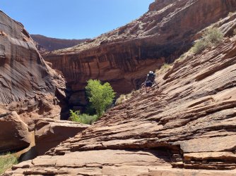
As for the "slickrock downclimb from Coyote to the Escalante", that doesn't really exist (EDIT: it does exist; see desertvic's post below). There's a slanted cliff edge you have to walk along inside Coyote Gulch before dropping back down to the canyon floor and walking another 1/4-1/2 mile to the river. We call it "Sketchy Ledge", and since it's the only bit of exposure you'll experience up to that point, it will definitely make you pause. It's essentially right where you drop into Coyote Gulch from Crack In The Wall. Stay relatively low and near the edge, despite the urge to go up high. I'd only avoid it if it's completely covered in loose sand. The fall is perhaps 30-40 feet onto a jumble of rocks, despite how deceptively short distances look in the attached pic. If this ledge feels too scary, the alternate high route on the opposite side of the gulch is an option (never done it) but I would assume there are spots with exposure along a narrow path. I'd take one route to Stevens and the other route on the way back for variety/views.IMG_9008.jpeg
 
Last edited:
We had a great time in Coyote Gulch. Came in from Red Well and enjoyed the walk, quite a bit in the creek. Camped a bit beyond Cliff Arch. Had no one anywhere near though a pair of rangers did come by to inspect the camp. They were pleased to see we had a canister stove set up and asked to see our wag bags. We day hiked towards the confluence day 2 but saw that ledge and said "good enough". Great area despite the popularity. Learning experience too as we woke to a lot of sand in the tent after a windy night. MSR Freelight has a lot of mesh.

Did this on a 2 week visit of Bryce, Zion, GSE and the Wave. Lots left to see

IMG_0087.JPG
IMG_2807_LargeB.JPG
 
Last edited:
I can't add much to what's already been said, as I did the loop down at JH Arch and up the Crack as a day hike. I have no memory of the ledges down to the Escalante causing me any concern at all. The hike up to the Crack is a long, sandy slog and my first thought was to skip that part, but I do remember that the views out over CG and to Steven's Arch were quite nice.
 
> 3) How tricky is the slickrock downclimb getting from Coyote to the Escalante? I know everyone's ability and comfort zone are different, but we really want to get to the river. Any tips to help us succeed? What's the alternative route like that Jamal describes in his AcrossUtah info?

Not sure which down climb you are referring to, but as mentioned above, there is this slanted cliff ledge you have to walk along inside Coyote Gulch before dropping back down to the canyon floor.

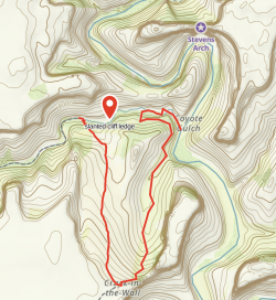
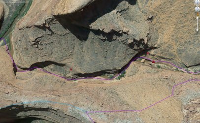
You could take the route on the north side of the canyon (described on Jamal's website) but since you said you want to go up to crack in the wall, you could follow the route marked in red in the following map.

You would avoid the slanted cliff ledge, and take a scenic way down to the Escalante with great views of Steven's arch. There is a good social trail to follow. To drop down Coyote, you have to find a steep slick rock descent (sorry no picture, but it would be easy to find with the map below), and then a final scramble down the canyon. Super easy and in my opinion, less dangerous than the slanted cliff ledge.

Edit: I actually have a video taken at the top of the slick rock descent. You can see my wife in the distance scouting for a way down canyon. It looks steep but with good shoes it's absolutely no problems.

CleanShot 2024-02-14 at 10.36.29@2x.png
 
Last edited:
2) Should we consider entering and exiting from Red Well instead of Hurricane?
You can also come in from the end of the road past Chimney Rock. I've entered both Coyote Gulch and Hurricane Wash from this spot on day hikes and it is pretty straightforward to routefind into either canyon (see Michael Kelsey's guide for a description into Coyote Gulch from here). It would also allow you to see parts of both canyons in a loop, and cut off a few approach miles. Also, the TH at Hurricane Wash can be quite busy and you are unlikely to see anyone out this way.

6) I stumbled on Sleepy Hollow from looking at the cracks in the map and researched to figure out what those are. I know we will not do those slots, but I would love to go up canyon a little and get to the giant alcove and perhaps camp there (Jack Brauer's photos are extremely enticing). I'm a bit uncertain, though, if it's between Coyote Gulch and the fork for Big Tony/Long Branch (perhaps halfway between?), or if it's past the fork and up Big Tony a little bit. Also, is there one alcove, or two facing each other? If you've gone up there, I would greatly appreciate details.
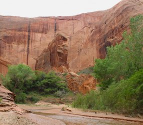
I've been in Sleepy Hollow twice (in 2020 and 2022) and found it worth the visit both times. You enter just above the mouth of the canyon, near the "h" in "Gulch" on the USGS topo, which avoids thick brush at the actual mouth. There is a trail in places but you'll have to do some bushwhacking to get to the two big alcoves, which sit across from each other. The biggest alcove has a great protected campsite and deep pool below it. You can hike farther up the canyon but it was pretty brushy in 2022 and I didn't go much farther. Despite its proximity to JHA I've not seen much sign of humans up that way either time.

Coyote Gulch above its confluence with Hurricane Wash to Sleepy Hollow had quite a lot of brush in places in 2022, but this may have changed if there have been some flash floods since then.

Looks like a great trip!
 
It's great to read all these replies and start digesting your info. Thanks, everyone. And I welcome additional information if anyone wants to share. With a long wishlist of future trips, we might not make it back again and want to maximize our opportunity!

A few specifics:

A day-hike up to Crack-in-the-Wall could be fun, but it's a steep and sandy route
I think we'll be ok with this. We've loved our adventures at the gigantic dunes along Lake Michigan, and I'm curious to see how this compares to those.

Instead of camping in lower Stevens (not ideal)
I'd love to hear more about why camping in lower Stevens is not ideal.
(I think Jamal's website even has a photo with a line drawn to show the route)
Yes! It's interesting to see his arrows showing the route. I'm guessing it will be a bit more challenging to figure it out than his arrows make it seem. ;)
Stay relatively low and near the edge, despite the urge to go up high.
Helpful to know this for the "Sketchy Ledge" - thanks. As I expected, this type of thing is a big deal to some people and less so or not at all to others. I'll be interested to see what it's like for us.
A final option is a dry camp up top on the alternate high route between Coyote and Stevens, at the same height as Stevens Arch on an epic peninsula in the sky
I'm intrigued by this option. Have you done this? If so, I'd love to hear about your experience camping up there.

follow the route marked in red
Very helpful to see your map and video - thanks!

You enter just above the mouth of the canyon, near the "h" in "Gulch" on the USGS topo,
That fits with what I had read elsewhere. Just marked it on my map - thanks!
 
I'd love to hear more about why camping in lower Stevens is not ideal.

Helpful to know this for the "Sketchy Ledge" - thanks. As I expected, this type of thing is a big deal to some people and less so or not at all to others. I'll be interested to see what it's like for us.

I'm intrigued by this option. Have you done this? If so, I'd love to hear about your experience camping up there.
Stevens near the mouth is narrow without many flat spots, and depending on the year it can be quite brushy and mucky with gross standing water.

You mentioned you didn't want anything past "Class 2". Even dropping through Crack In The Wall must be Class 3 (but completely harmless). And although you probably don't need to use your hands to cross Sketchy Ledge, a fall would have serious consequences. So technically, it's probably a 3 or 4, even though for some people it would be like walking on a city sidewalk that's angled because of tree roots. I've done a long Allen loop and the trip to Halls Creek Narrows from there, and both times I hesitated. By the end of the trips, I laughed at how trivial the ledge seemed compared to all the other foolish things I'd done.

I haven't camped up high on that peninsula because I'm lazy about dry camps even though you could be at water in probably 30 min. Jarl or Joey used to have a Youtube video showing it, with a perfect-looking flat spot and epic views. That high alt is, of course, more work than the other two paths to the river.
 
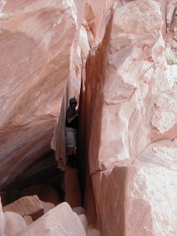
Only pics I could find. Crack...if I remember you can crawl up and over or go thru. And the terrain from the bottom headed up to it. There is a trailP1010092.JPGP1010095.JPG
 
Sounds like a good trip plan and lots of good advice already. Here are my initial thoughts:

-- "planning a midweek backpacking trip..." great plan! Try to stick with it as it really does make a pretty big difference re: crowd size even after spring break (most of my experience is in May.) Weekends definitively to be avoided if at all possible.

-- avoid camping around Jacob Hamblin Arch. It attracts probably 10x more campers than the lower canyon.

-- if you climb all the way out Crack-in-the-Wall, be sure to go see the amazing viewpoint just to the south looking back down on the big bend in the Escalante.

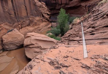
-- the "slanted ledge" in lower Coyote isn't terrible, but... it depends on the person and the conditions (eg sand). Many people walk right past it without slowing down, others can't do it and turn around. I've said it before but I'll repeat: some sidewalks are just as cracked and slanted and walking them wouldn't bother anyone, but when it's sandy and sloping toward a big drop-off it gets a bit scary!

Coyote_Gulch_ledge2-800x552.jpg

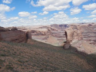
-- I've done the "steep slickrock" route downcanyon as well as described by @desertvic above and I actually found it more intimidating at the time. BUT... that was my first visit long ago so it's possible I was just a bit "green" back then. That route does have the advantage that a fall would likely only result in a tumble down the slickrock to a nice sandy flat patch. It's possible to get to that point w/o going all way up and around via social trail right above the "slanted ledge" route. Here's looking across to the "steep slickrock" route (note from a distance it looks even worse than reality IMHO.) One day I'll get around to putting all these details on my site along with video references.

DSC01175.JPG

-- Frequently on my site (and in videos) I describe stuff as a little more difficult/scary than most experienced hikers might find them to be (guess I'm the "Reverse Kelsey" in that sense!) That said, the High-Water Route alternate to Stevens (documented originally by Allen I think) and the route up under Stevens Arch really aren't that bad. I probably wouldn't recommend them to a complete novice, but in general there's nothing too hard/scary about either route. Making a loop out of the High-Water Route is great and standing under the arch is pretty amazing so I def recommend it if you have the time.

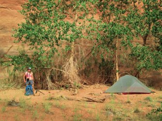
-- some people camp at the small spot right at the mouth of Stevens, but it's really not that great. A better option would to be continue up Stevens just about a quarter mile (through the initial brush) and then there's a decent spot that's larger. If that's taken there's nothing else that I can remember until above the Grotto. Another good-weather option would be behind the willows along the Escalante just downstream of Stevens.

LowerStevesCamp.jpg

BehindTheWillows.jpg

OK -- that's all I've got for now. ✌
 
I have no memory of the ledges down to the Escalante causing me any concern at all.
@napatony13 - I just remembered that you did the low route from Deer Creek to Tapeats and thought that was fine. We happily did the upper route! As much as I would love to have the same skill and risk tolerance as you, I clearly don't!
 
Stevens near the mouth is narrow without many flat spots, and depending on the year it can be quite brushy and mucky with gross standing water.

You mentioned you didn't want anything past "Class 2". Even dropping through Crack In The Wall must be Class 3 (but completely harmless). And although you probably don't need to use your hands to cross Sketchy Ledge, a fall would have serious consequences. So technically, it's probably a 3 or 4, even though for some people it would be like walking on a city sidewalk that's angled because of tree roots. I've done a long Allen loop and the trip to Halls Creek Narrows from there, and both times I hesitated. By the end of the trips, I laughed at how trivial the ledge seemed compared to all the other foolish things I'd done.

I haven't camped up high on that peninsula because I'm lazy about dry camps even though you could be at water in probably 30 min. Jarl or Joey used to have a Youtube video showing it, with a perfect-looking flat spot and epic views. That high alt is, of course, more work than the other two paths to the river.
Thanks for the additional info. I just watched some of the Jarl/Joey video, and that spot really does look great. Maybe we'll get there for a lunch break or something, and I'm guessing we'll camp down near the water in Coyote. The whole thing looks beautiful!
 
Sounds like a good trip plan and lots of good advice already. Here are my initial thoughts:

-- "planning a midweek backpacking trip..." great plan! Try to stick with it as it really does make a pretty big difference re: crowd size even after spring break (most of my experience is in May.) Weekends definitively to be avoided if at all possible.

-- avoid camping around Jacob Hamblin Arch. It attracts probably 10x more campers than the lower canyon.

-- if you climb all the way out Crack-in-the-Wall, be sure to go see the amazing viewpoint just to the south looking back down on the big bend in the Escalante.

-- the "slanted ledge" in lower Coyote isn't terrible, but... it depends on the person and the conditions (eg sand). Many people walk right past it without slowing down, others can't do it and turn around. I've said it before but I'll repeat: some sidewalks are just as cracked and slanted and walking them wouldn't bother anyone, but when it's sandy and sloping toward a big drop-off it gets a bit scary!

View attachment 129403

-- I've done the "steep slickrock" route downcanyon as well as described by @desertvic above and I actually found it more intimidating at the time. BUT... that was my first visit long ago so it's possible I was just a bit "green" back then. That route does have the advantage that a fall would likely only result in a tumble down the slickrock to a nice sandy flat patch. It's possible to get to that point w/o going all way up and around via social trail right above the "slanted ledge" route. Here's looking across to the "steep slickrock" route (note from a distance it looks even worse than reality IMHO.) One day I'll get around to putting all these details on my site along with video references.

View attachment 129404

-- Frequently on my site (and in videos) I describe stuff as a little more difficult/scary than most experienced hikers might find them to be (guess I'm the "Reverse Kelsey" in that sense!) That said, the High-Water Route alternate to Stevens (documented originally by Allen I think) and the route up under Stevens Arch really aren't that bad. I probably wouldn't recommend them to a complete novice, but in general there's nothing too hard/scary about either route. Making a loop out of the High-Water Route is great and standing under the arch is pretty amazing so I def recommend it if you have the time.

-- some people camp at the small spot right at the mouth of Stevens, but it's really not that great. A better option would to be continue up Stevens just about a quarter mile (through the initial brush) and then there's a decent spot that's larger. If that's taken there's nothing else that I can remember until above the Grotto. Another good-weather option would be behind the willows along the Escalante just downstream of Stevens.

View attachment 129405

View attachment 129406

OK -- that's all I've got for now. ✌
Thanks for all of this. Your videos & descriptions have been really helpful already and I appreciate your additional info & pics.

For the "steep slickrock" route, I'm trying to figure that out based on @desertvic's map and your photo. I'm looking at the satellite imagery on Caltopo, and it seems like you go down a bit from the Crack and then go on the east side of the fin and then when you get close to Coyote there are social trails which might be the ones in your photo. I just looked on Google Earth and the images seem pretty distorted, so that's not helping much. I assume that not many people go this way instead of on the typical trail. I guess we'll figure it out when we're there. I definitely am looking forward to that wonderful view from above the Crack!
 
Here's a SAT view rotated 180 so that N is at the bottom: LowerCoyote2.JPG

The Escalante is seen on the left, big fin is seen at top, and sand dune route up to Crack-in-the-Wall in on the right.

❗ on the left is the "steep descent"
❗on the right is the "slanted ledge"
❗above/left of "slanted ledge" is another route which requires climbing (not recommended)

The "steep descent" route can be accessed via social trails either east or west of the "fin". It appears that the trail from the west is more popular but it's hard to tell for sure. I haven't done either route as once I climbed up I went back down and did the ledge route instead. I have a video overview of this which I might be able to dig up soon.

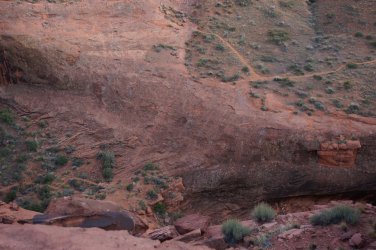
Funny... I just found another photo I had from below the "steep descent" and it doesn't look that bad. So now I don't know which of my own memories to trust! Not a great pic, but here it is. The steep part is almost out of view at the top right. After that descent you traverse sideways for a short ways before being able to get down to the canyon floor.

Coyote_Gulch_Lower3.jpg
 
Last edited:
Funny... I just found another photo I had from below the "steep descent" and it doesn't look that bad. So now I don't know which of my own memories to trust! Not a great pic, but here it is.
It's really not that bad, so I am sure you were either green or your memory is failing you :)

Great satellite imagery, though. You can clearly see the social trail that goes around the butte.

-Victor
 
@napatony13 - I just remembered that you did the low route from Deer Creek to Tapeats and thought that was fine. We happily did the upper route! As much as I would love to have the same skill and risk tolerance as you, I clearly don't!
Hi Janice, big difference between the two. The low route danger was obvious (trip/slip and die) and a memorable experience that sticks with you. I had no memory of the ledges in CG, and only after seeing the pictures in this thread did I even know what spot was being discussed. It just didn't register as being dangerous. The steep shortcut descent to JH Arch had my attention, but after that there was nothing that seemed risky to me.
 
I think this is looking upstream from around that spot in CG:
DSC04372.jpg

p.s. If this gives you pause, lower Stevens has at least one short 4th class move you'll need to get through before "poison ivy hill".
 
Last edited:
Similar threads
Thread starter Title Forum Replies Date
XID_AZ Coyote Gulch Northish Side Canyons Trip Planning 0
RyanP Coyote Gulch to Halls Creek via Steven's Canyon and the Baker Route (car/key swap) Meet Up (Members Only) 8
A Coyote Gulch crowds? Trip Planning 0
C Coyote Gulch via Chimney rock trail Trip Planning 0
J Trip first week of April 2021 Southern UT/Anywhere AZ - Death Hollow, Coyote Gulch, or other suggestions? Trip Planning 9
D Coyote Gulch to Lake Powell Trip Planning 8
D Coyote Gulch additional parking Trip Planning 3
RyanP Coyote Gulch to Halls Creek via Stevens Canyon Trip Planning 28
F Coyote Gulch via Dry Fork? Trip Planning 2
Jon Carbaugh A Leisurely Stroll Through Coyote Gulch Backpacking 11
DrNed Coyote Gulch Pit Toilet Trip Planning 14
Mikjik86 Backpacking Coyote Gulch, 3 Days, 2 Nights- October 2018 Backpacking 2
cjhaines Coyote Gulch Trailhead Trip Planning 2
Stephanie Quick trip to Coyote Gulch via Red Well Trip Planning 4
C New Member - Coyote Gulch Solo Trip Noobs: Introduce yourself! 8
Devin Ashby Coyote Gulch Loop Starting From Water Tanks Trip Planning 4
Eric_LV Hiker Coyote Gulch trip May 20-23 Trip Planning 16
Nick New Waste Disposal Requirements for Coyote Gulch Visitors General Discussion 11
J Big Escalante Backpack Loop: Stevens/Fold/Bobway/Coyote Gulch April 25-30, 2015 Backpacking 8
mike54704 Backpacking in Coyote Gulch the first week of March Trip Planning 26
slc_dan Too Good for the Cinema Thread-Andrew Bird in Coyote Gulch! General Discussion 3
steve Coyote Gulch Backpacking 10
natylka Backpacking: Hurricane Wash into Coyote Gulch of 26 miles back in May Backpacking 3
IntrepidXJ Coyote Gulch Backpacking 18
BrendanLB Coyote gulch via 40 mile ridge road Trip Planning 17
DrNed Coyote Gulch April 10-12 Backpacking 27
DrNed Springs in Coyote Gulch Trip Planning 2
DrNed Map for Coyote Gulch Trip Planning 6
Tater Head Coyote Gulch... Trip Planning 11
Bob Coyote Gulch Resource Discussions 0
M Coyote Gulch next week and footwear recommendations? Trip Planning 1
Howells Outdoors Coyote Gulch Backpacking 15
powderglut Return To Coyote Gulch Backpacking 7
Aldaron Coyote Gulch Backpacking 4
NAYR Coyote Gulch Backpacking 7
Dave Coyote Gulch, March 22-24 2013 Backpacking 22
Ericephoto Coyote Gulch via Jacob Hamblin Arch trail and Crack in the Wall Backpacking 11
powderglut Coyote Gulch Route? Trip Planning 56
Nick Coyote Gulch Pit Toilet Destroyed? General Discussion 32
J Coyote Gulch btw 22 and 27 May - anyone wanna share a ride? Trip Planning 0
Bill Coyote Gulch Conditions 7.2012 Trip Planning 0
Nurrgle Backpacker's America's Best Camp Sites - Coyote Gulch General Discussion 7
wes242 First time to Coyote Gulch Backpacking 4
Tyler Coyote Gulch, Escalante Utah - 5 year anniversary backpacking trip Backpacking 6
Yvonne Invite Coyote Gulch Meet Up (Members Only) 49
gloo Coyote Gulch Trip Planning 20
Nick Coyote Gulch Loop Backpacking 20
SteveR Coyote Buttes South- New Daily Permit Process Trip Planning 8
S Driving to poverty flats (South Coyote Buttes) on AWD Trip Planning 11
Janice Vermillion Cliffs Trip - Part 2 - White Pocket & Coyote Buttes South Hiking & Camping 7

Similar threads

Back
Top