Joey
walking somewhere
- Joined
- Apr 1, 2014
- Messages
- 878
This is a 5 day backpacking loop I did in Yellowstone National Park. I did this back in July, 2012, but its a pretty neat loop, possibly one of the best trips I've done in the park, so I thought I would share. Here is the trip route: http://caltopo.com/map?id=3S43 . I have a trip video for this, which is basically a photo slideshow, with a few neat video clips. You can check it out here:

We started at the Lamar River Trailhead, in the northeast corner of the park. The first part of the hike is through the open Lamar Valley.

Lots of Buffalo, and quite swampy near the river. My friend Kyle, who was hiking with me, sunk down to his waste in the mud.

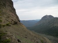
About 4 miles in, we forded Cache Creek, which wasn't deep but a little swift. After that, the canyon narrows around the river, and much of the terrain is fire burn. It was really hot and dry.


It was late in the day by the time we reached Miller Creek. Miller Creek is really nice. Some fire burn exists, but its prettier than the Lamar River stretch. Lots of grizzlies around, and we couldn't help but notice all the scat and tracks. Its fairly common to see this in the Yellowstone backcountry, but it started getting excessive. We camped at backcountry campsite 3M2, which I think is the creepiest campsite I've stayed at (on par with a few along the Yellowstone River in the Thorofare). The food prep area is surrounded by the creek, and thick, dark woods with lots of grass and uneven terrain surround that. So we couldn't hear or see anything. Oh yeah, and there was grizzly scat all around the fire pit. Neither of us slept well that night.


Kyle at the food prep area the morning of day 2

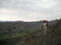
Day 2 we headed up Miller Creek towards the Hoodoo Basin. We followed the river for several miles.


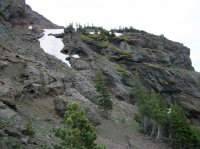
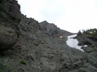
Soon we began to climb out of the drainage, and the views got good

We went up about 2 thousand feet, and soon were on a nice alpine ridge. We passed Parker Peak, and went through a saddle were we dropped into the Hoodoo Basin.


Dropping down into the Hoodoo Basin


The Hoodoos, and Hoodoo Peak


We set up camp at backcountry campsite 3M7, which was near the Hoodoos, but in beautiful alpine meadows, with some nice views. Kyle commented that he felt better here than the night before, since he didn't think there were any bears around.


After setting up the tent, we went to our food prep area, and started cooking dinner. I was in the middle of cooking some cheesy potatoes, when Kyle calming stated there was a grizzly bear in front of us. I thought he was kidding, but sure enough a grizzly was about a hundred yards away, grazing in a ravine that runs below the food prep area. Kyle went closer to get a better look, and I watched him through the binoculars. Photos are taken from our food prep area.


While I was watching him, he lifted his head and winded us. Then he put his head back down and acted like he was still eating. But he wasn't. I could see his mouth close up through my binocs, and he was just moving his head through the grasses. I've read that bears will do this sometimes, like they are thinking about what they are going to do, and don't want to let anything know they know we are there. (Since this incident, I've witnessed this happen once more). Soon he lifted his head, and took a few galloping steps in our direction, before suddenly turning around and running off.

Later that evening we walked past our camp to look around, and realized the bear had been digging all around us. He had probably been around a few days, and we were no doubt the first people to come through that year. Another night of somewhat light sleeping, but it was really pretty.


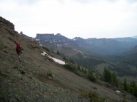
Day 3 might be one of the most spectacular days of hiking I've done in Yellowstone National Park. We followed the trail to the park boundary, which looked like a giant golf course.


Finally we made it to the Park's boundary with the North Absaroka Wilderness. There were spectacular views in all directions. The Beartooth's to the north, the Absaroka's to the east and south, The Tetons way off in the distant southwest, and all of Yellowstone to the west. I think this is the most spectacular spot I've been to in Yellowstone.


Things only got better. From here, we left the trail, and headed southwest, following the park boundary. There is a faint game trail here in some places, although you don't really need a trail to travel. Pretty easy walking. And just wow views:


As we rounded the Hoodoo Basin, and approached Lamar Mountain, we noticed a patrol cabin that isn't shown on the maps. I've since asked about it, and turns out backcountry rangers still use it to do poacher patrol in the fall.

Now back to walking up to the top of Lamar Mountain:


And more spectacular views at the top of Lamar Mountain:


In these next pictures, your looking back north, northeast. Hoodoo Basin is below, and the snowcapped Beartooth's can be seen way off in the distance:


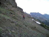
We continued to follow the ridge along the park boundary, going up and down


This next view is looking down the Little Lamar River drainage.

We continued on


We found an old can of bear spray, empty with a hole in it. Maybe someone shot it, maybe a bear got ahold of it.


We were lucky enough to see some Bighorn Sheep.


Finally we set up camp along the ridge, just outside the Yellowstone Park Boundary.


Day 4 rainy weather moved in. We had already dropped down a bit from the ridge (instead of following the obvious route around the drainage). We skirted around cliffs, with Kyle trying to convince me to drop down into the valley, and me trying to convince him to climb up to the ridge top.


The rain got harder, and Kyle won the argument. We dropped down to the Little Lamar River. At first we were able to find an old game trail, which we followed for a while.


Then we reached fire burn, and extreme downfall. To add to the misery, the mosquitos were intense. It took us several hours to go the final few miles down to the Lamar River. Once at the Lamar, we followed that down to the main trail.


Oh yeah, grizzly scat was everywhere again

We reached the trail as it began to really downpour. We found our campsite 3U3, and went to bed early.
Day 5 we headed north, down the Lamar River.


The very next backcountry campsite to where we had camped was closed because of bears. Apparently there was a grizzly on a carcass in the campsite.

We continued on down the trail. Although much of the hillside is burned, some areas along the river are beautiful.


We were suppose to camp one more night along Cache Creek, but talk of food got the better of us, and we hiked another 4 miles back to the trailhead.


We drove up to Cooke City, where we ate deep fried Sloppy Joes and deep fried Snickers. If you ever find yourself in Cooke City during the summer, definitely try one of these.

After dinner, we drove back down to the trailhead, and slept in the van (since we still had a permit to be parked there. As an FYI, its not really allowed, and they do check for that). We had a beautiful sunset, and got to listen to wolves howl. Only time we heard wolves on that trip.

Featured image for home page:

We started at the Lamar River Trailhead, in the northeast corner of the park. The first part of the hike is through the open Lamar Valley.
Lots of Buffalo, and quite swampy near the river. My friend Kyle, who was hiking with me, sunk down to his waste in the mud.
About 4 miles in, we forded Cache Creek, which wasn't deep but a little swift. After that, the canyon narrows around the river, and much of the terrain is fire burn. It was really hot and dry.
It was late in the day by the time we reached Miller Creek. Miller Creek is really nice. Some fire burn exists, but its prettier than the Lamar River stretch. Lots of grizzlies around, and we couldn't help but notice all the scat and tracks. Its fairly common to see this in the Yellowstone backcountry, but it started getting excessive. We camped at backcountry campsite 3M2, which I think is the creepiest campsite I've stayed at (on par with a few along the Yellowstone River in the Thorofare). The food prep area is surrounded by the creek, and thick, dark woods with lots of grass and uneven terrain surround that. So we couldn't hear or see anything. Oh yeah, and there was grizzly scat all around the fire pit. Neither of us slept well that night.
Kyle at the food prep area the morning of day 2
Day 2 we headed up Miller Creek towards the Hoodoo Basin. We followed the river for several miles.
Soon we began to climb out of the drainage, and the views got good
We went up about 2 thousand feet, and soon were on a nice alpine ridge. We passed Parker Peak, and went through a saddle were we dropped into the Hoodoo Basin.
Dropping down into the Hoodoo Basin
The Hoodoos, and Hoodoo Peak
We set up camp at backcountry campsite 3M7, which was near the Hoodoos, but in beautiful alpine meadows, with some nice views. Kyle commented that he felt better here than the night before, since he didn't think there were any bears around.
After setting up the tent, we went to our food prep area, and started cooking dinner. I was in the middle of cooking some cheesy potatoes, when Kyle calming stated there was a grizzly bear in front of us. I thought he was kidding, but sure enough a grizzly was about a hundred yards away, grazing in a ravine that runs below the food prep area. Kyle went closer to get a better look, and I watched him through the binoculars. Photos are taken from our food prep area.
While I was watching him, he lifted his head and winded us. Then he put his head back down and acted like he was still eating. But he wasn't. I could see his mouth close up through my binocs, and he was just moving his head through the grasses. I've read that bears will do this sometimes, like they are thinking about what they are going to do, and don't want to let anything know they know we are there. (Since this incident, I've witnessed this happen once more). Soon he lifted his head, and took a few galloping steps in our direction, before suddenly turning around and running off.
Later that evening we walked past our camp to look around, and realized the bear had been digging all around us. He had probably been around a few days, and we were no doubt the first people to come through that year. Another night of somewhat light sleeping, but it was really pretty.
Day 3 might be one of the most spectacular days of hiking I've done in Yellowstone National Park. We followed the trail to the park boundary, which looked like a giant golf course.
Finally we made it to the Park's boundary with the North Absaroka Wilderness. There were spectacular views in all directions. The Beartooth's to the north, the Absaroka's to the east and south, The Tetons way off in the distant southwest, and all of Yellowstone to the west. I think this is the most spectacular spot I've been to in Yellowstone.
Things only got better. From here, we left the trail, and headed southwest, following the park boundary. There is a faint game trail here in some places, although you don't really need a trail to travel. Pretty easy walking. And just wow views:
As we rounded the Hoodoo Basin, and approached Lamar Mountain, we noticed a patrol cabin that isn't shown on the maps. I've since asked about it, and turns out backcountry rangers still use it to do poacher patrol in the fall.
Now back to walking up to the top of Lamar Mountain:
And more spectacular views at the top of Lamar Mountain:
In these next pictures, your looking back north, northeast. Hoodoo Basin is below, and the snowcapped Beartooth's can be seen way off in the distance:
We continued to follow the ridge along the park boundary, going up and down
This next view is looking down the Little Lamar River drainage.
We continued on
We found an old can of bear spray, empty with a hole in it. Maybe someone shot it, maybe a bear got ahold of it.
We were lucky enough to see some Bighorn Sheep.
Finally we set up camp along the ridge, just outside the Yellowstone Park Boundary.
Day 4 rainy weather moved in. We had already dropped down a bit from the ridge (instead of following the obvious route around the drainage). We skirted around cliffs, with Kyle trying to convince me to drop down into the valley, and me trying to convince him to climb up to the ridge top.
The rain got harder, and Kyle won the argument. We dropped down to the Little Lamar River. At first we were able to find an old game trail, which we followed for a while.
Then we reached fire burn, and extreme downfall. To add to the misery, the mosquitos were intense. It took us several hours to go the final few miles down to the Lamar River. Once at the Lamar, we followed that down to the main trail.
Oh yeah, grizzly scat was everywhere again
We reached the trail as it began to really downpour. We found our campsite 3U3, and went to bed early.
Day 5 we headed north, down the Lamar River.
The very next backcountry campsite to where we had camped was closed because of bears. Apparently there was a grizzly on a carcass in the campsite.
We continued on down the trail. Although much of the hillside is burned, some areas along the river are beautiful.
We were suppose to camp one more night along Cache Creek, but talk of food got the better of us, and we hiked another 4 miles back to the trailhead.
We drove up to Cooke City, where we ate deep fried Sloppy Joes and deep fried Snickers. If you ever find yourself in Cooke City during the summer, definitely try one of these.
After dinner, we drove back down to the trailhead, and slept in the van (since we still had a permit to be parked there. As an FYI, its not really allowed, and they do check for that). We had a beautiful sunset, and got to listen to wolves howl. Only time we heard wolves on that trip.
Featured image for home page:
Attachments
-
 Yellowstone July 2012 585.JPG88.1 KB · Views: 41
 -
 Yellowstone July 2012 587.JPG68.5 KB · Views: 42
 -
 Yellowstone July 2012 590.JPG85.5 KB · Views: 39
 -
 Yellowstone July 2012 591.JPG123.8 KB · Views: 41
 -
 Yellowstone July 2012 592.JPG134.8 KB · Views: 44
 -
 Yellowstone July 2012 594.JPG99.9 KB · Views: 72
Last edited:
") . We probably should have done the lightning method, and spread out. That way if one of us got attacked, the other one could get away.
. We probably should have done the lightning method, and spread out. That way if one of us got attacked, the other one could get away.