- Joined
- Aug 21, 2018
- Messages
- 781
I like visiting Yellowstone during the month of September, and was fortunate to make a return trip in 2023 after the epic August Thorofare adventure. @scatman had invited me and good friend Cody for a couple nights he planned near the Gallatin River. Brother Patrick ( @CajunPoncho ) was invited as well, but he had some preexisting work commitments and could not join us.
Last year I put Cody thru some long miles/rough terrain on our Bog Creek Bushwack and Pelican Creek Hypothermia Hike. I promised him things would be more tame this time around. . . at least as much as Hugh would allow.")
Cody and I flew into Bozeman on the evening of September 7th. The variable pricing on airline tickets made it more cost effective to fly in the night before we were to meet up with Hugh and spend the night at a hotel in town. (Yep, flight + hotel on Sept 7th was $100 less a person than a flight on Sept 8th!) We were supposed to have a hotel shuttle pick us up at the airport, but the shuttle driver went home early and we had to fend for ourselves. Luckily the rental car people were nice and let me pick up our vehicle a day (night) early. I always reserve a compact car/the cheapest option and never know what they are actually going to give me. This year I was given a Cadillac Escalade.
Day 1: Thursday, September 7, 2023
Cody and I planned to meet Hugh and his group of work friends for lunch in West Yellowstone. We left Bozeman early and took our time driving down the Gallatin Gateway towards the park. Tradition demands we stop and take a picture of the Yellowstone sign with Black Butte looming, so we gave in to those demands.

Somewhere near the boundary of the park before reaching West Yellowstone we noticed some critter movement on the side of the road. We pulled off and watched what I think must have been a group of four or more Coyotes.


We had several hours before Hugh and the Gang were due to arrive, so I took Cody on a side trip to an area I've heard and read about for years but had never seen. A turn West on Highway 287 took us toward Hebgen Lake and the site of the landslide that created Earthquake Lake.
My fascination with thermal features has provided an understanding that many geyser/hots spring/etc. behavior changes were caused by the 7.5 earthquake on August 17, 1959. The earthquake also created a landslide in the Madison River Canyon that took the lives of many unsuspecting campers and blocked the flow of the Madison River. I have always wanted to take a side trip to see the area, and today provided a good opportunity to do so.
Cody and I drove along the highway near Hebgen Lake, passed by Hebgen Dam, and there it was. . . Earthquake Lake. A forest of trees still stands submerged in its waters. Seeing the scale of the landslide in person finally put a visual to all the stories and history I had read about the area. The huge hole left in the mountain is still clearly visible on the left and the volume of rubble blocking the canyon is massive.

A view looking West from the landslide area. It was much more open than I was expecting; I can see why this would have been a popular camping spot in 1959.

A look back East of Earthquake Lake from the landslide area. The earth is an amazing place. . . I might pursue a career in geology if I ever decide to grow up some day.

Cody and I headed back East, for it was nearing time to meet up with Hugh and the group of guys we'd be camping with the next couple days. We met at the West Yellowstone Backcountry Office to gather our permit. @scatman was punctual as always and introduced us to Brent, Ryan, Mark, and Danny. The backcountry ranger was the same individual that gave us our permit for the Bog Creek adventure last year. He actually remembered us and seemed a bit surprised we completed the trip as planned. He gave us this year's permit without making us watch the bear video, so I'll give him a thumbs up.
The next stop was Ernie's Bakery, Sandwich Shop, and Deli for lunch before hitting the trailhead. There were four different vehicles amongst our group of seven and everyone scattered in different directions. We all arrived at Ernie's. Everyone else ordered a light lunch but I went the opposite direction with a cheesy burger.


Lunch was good. We all walked out of Ernie's with the instruction to meet up at the Bighorn Pass Trailhead -- about 20 miles North of West Yellowstone. Four different vehicles scattered in what seemed like four different directions again. Cody, Hugh, Ryan, Brent, and I all arrived at the parking area within minutes of each other. Danny and Mark needed to pickup some coffee, so they would be a few minutes later than the rest of us.
Getting ready at the trailhead.

A few minutes turned into 30 minutes or more as we waited for Mark and Danny. Cell range is nonexistent at the Bighorn Trailhead, so Hugh drove Brent and I South on 191 until we found service just North of West Yellowstone. Calls to both Danny and Mark went directly to voicemail. Messages/texts were left, and we headed back to the trailhead -- 20 miles North of West Yellowstone. All this activity took another 30 minutes or so. When we arrived back at the trailhead it was raining, but Danny and Mark's car was there. It turns out they had driven quite a distance North -- outside of the park boundary in fact -- before turning around and making their way back. They had also packed up and started out on the trail, leaving the rest of us to catch up. Perhaps this was part of their plan all along.
Map at the Bighorn Trailhead. We would be staying several nights at campsite WB1, about four miles from the trailhead, which is about 20 miles North of West Yellowstone.")

It was just a month ago that I had been hiking 8+ miles a day, sometimes over some serious elevation with quite the heavy pack. I reasoned that if I could make it all that distance across the Thorofare and Teton Wilderness with the weight of 10 days of food, gear, etc. I could make it four miles into basecamp with a couple extra luxury items this time. Such items included a camp chair, an extra camera lens, and some additional beverages. Luckily my pack accommodated the case of Cold Smokes (eight cans!) easily. Cody hauled in another four in his pack. I forgot to have a picture taken of me with my loaded pack in action, so this one from the hotel will have to do.

Trailhead Photo -- everyone except Mark and Danny. Right to left: Brent, Cody, Ryan, Hugh, and myself.

I've been to a lot of areas in Yellowstone National Park, but have not spent much time in the Northwest corner. I have always wanted to see what is out here so I was very happy to take Hugh up on his offer to join his party -- group of scallywags that they were proving to be.
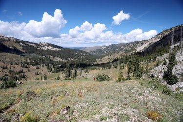
The hike to WB1 follows a path near the Gallatin River at times, and at other times covers some higher ground just North of the river. Hills guarding the sides of the valley were usually part of the view.

Follow the leader. Ryan in this case. I quickly learned that Ryan hikes at a brisk pace. It was a challenge to keep up with him!

One of the times the trail passes close to the Gallatin River. Mark and Danny sighting ahead!

Brent is getting the shot. Unlike me, Cody does not take a lot of pictures. I think he told me he took less than 50(?) pictures during our entire trip, and most of those were probably of some Bison we encountered on the road when we were leaving the park.

The large hill at the right dominated the view for most of the hike. We would eventually pass it. Getting closer to Mark and Danny.

The trail climbs up into a rocky hillside with trees to provide some shade. An interesting change to the open valley we had previously been hiking in.

WB1 this way!

The view East (up Gallatin River Canyon) from campsite WB1.

Home for the next two nights. I very much liked the surroundings of Campsite WB1. There were enough trees around to provide some cover, but not enough to block the views up and down the valley. The Gallatin River was a short walk to retrieve water, and some kind of cascading spring/water feature was present on the opposite bank. While it was not visible thru the trees it was audible and provided gentle splashing sounds that easily lured one to sleep. . . or woke one up with thoughts of needing to pee.

Looking upstream from campsite WB1's water supply.

The water in the Gallatin River was COLD. Normally I'd jump in and splash off the grime of the day -- luckily four miles does not allow enough time for a lot of grime to build up. No way I was jumping in this water anyway; it numbed my fingers just filling water bottles. Cold water has its advantages though, and we used it as nature's refrigerator.

Group shot of everyone gathered for supper. Danny and Mark were experts at getting the fire going and gathering enough wood to keep us supplied for days to come.

Mother Nature provided a nice evening light show and also blew in a rain shower or two -- something that would continue to be a trend. Never enough to describe as a soaking but just enough to provide some variety and atmosphere. We all headed off to bed shortly after the rain started falling in the dark.

Day 2: Friday September 8, 2023
I've not yet discussed the plans for the day(s) spent while at campsite WB1, have I? Did you think we were going to sit around the fire and drink beers all day? (Not to say it was not a consideration. . . ).
Hugh had some day hikes in mind and today we would take a walk up the Gallatin River Valley to Bighorn Pass. Hugh, Brent, Ryan, Cody, and I would attempt the out and back hike while Danny and Mark would explore the area around camp.
It did not take long for Danny and Mark to get a good fire going for breakfast and we watched the sun rise from the eating area.

Shortly after breakfast we packed our day bags and hit the trail heading towards Bighorn Pass. I had not noticed the fog on my lens when I took this picture.

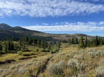
The trail wound its way on the North side of the Gallatin River. The hike up valley began with a gentle ascent thru open terrain and the occasional patch of forest.

Everyone moved at a good pace. I practically had to run up the trail to get a picture of Ryan walking towards me, the fast hiker that he is.

If one of us moved too far ahead on the trail we would stop and wait for the others to catch up. It was during one of these rest stops that I was lured into the woods by the siren song of rushing water.
I knew there was a waterfall hiding somewhere in the cliffs to our North and I planned on taking a side trip up to see it during the hike back. I'm not very good at standing still, so I thought I'd scout out the area to see if I could maneuver a route to the falls while the others caught up. Cody came with me, and we told Ryan to move ahead if we were taking too long -- we would catch up.
Following the sound of the water led us to this playful creek.

Temptation to follow the creek up the hillside was strong. . . as the sound of crashing water grew louder and louder with each step I knew I might as well follow the noise to its source.
The setting of Stone Hollow Falls is quite spectacular. The water plummets thru a hole in a near vertical cliff face. The rock forms a small, natural bridge just ahead of the opening the water drops into. The approach to the main falls is narrow, full of brush, and quite slippery. I had to navigate up the creek bed to reach it. Cody decided to wait for me here in case I slipped up. He figured I would walk or wash down the creek eventually.

View from the base of the falls. Standing here was quite the multi-sensorial experience.

Cody and I spent about 15 minutes at the falls before heading out to catch up with the rest of the group.
The trail took us thru a woodsy area and showed evidence of all types of foot traffic.

The trail climbed steadily alongside the Gallatin River, which was beginning to look more like a creek.

Cody and I caught Hugh, Ryan, and Brent as they were taking a sunscreen break.
This was the view up valley from our rest spot. Pictures taken towards the East in the morning tend to get washed out by the sun.

So most of the morning pictures during the hike were taken by turning around and looking back West.

The approach to Bighorn Pass veered away from what was left of the Gallatin River and began to climb some appreciable elevation. We encountered impressive patches of wildflowers that still had beautiful blooms.

One of my favorites. Hugh told me what it was, but I've since forgotten.

Looking back down the Gallatin River Valley. Cody is right behind Ryan in this picture and Brent is a little farther downhill to Ryan's right. Hugh is even in this picture -- he is the faint pink dot that is above Brent.

A view to the right from the trail and the headwaters of the Gallatin River.

The map suggests that is Three Rivers Peak in the distance. I was hoping to catch a view of Gallatin Lake in the bowl at the base of the peak, but I do not recall it being visible from the pass.

Final push to the top of the pass. The wind started to pickup and became quite a force to recon with on the top of the pass.

Success!

Taking a rest at the top of the pass. Brent took cover out of the wind on the Northeast facing side. He was probably the smart one.


View into Yellowstone National Park from Bighorn Pass. Somewhere out there is Mammoth Hot Springs.

Group Photo

Wide Angle View.

We did not linger on the pass for long. The wind was chapping my lips by the minute. The hike back down the valley retraced our steps up. The sun was now moving towards the West so I ended up taking more pictures behind than ahead again.


On the walk back to camp I might have mentioned the off trail waterfall once or twice. The group seemed interested enough to accompany me for a return visit. The approach was just as treacherous as the first time, but by afternoon the light had changed and provided a blue sky for pictures.


As we left the waterfall it was hard not to notice the clouds building to the West.


Still a little blue to the East.

Luckily there was no heavy rain, just some hit and miss showers that made having a campfire that much more enjoyable.
Beef Stroganoff was the dinner of choice at Hugh's recommendation. It did not disappoint. The beer was good too. Luckily no Grizzlies raided our fridge while we were away.

This picture looks like it could be a meme. Add your own caption here.

Dinner group shot.

As the sky grew dark Cody, Ryan, and I continued to hang out by the fire while everyone else headed for their tents. The sky changed by the minute with swirling clouds, twinkling stars, and the occasional flash of lighting. I tried propping the camera up on a rock or a stump for some pictures.

The rain did eventually begin to fall with more force and the three of us decided it was time to call it a night. We gave the fire a good dousing and turned in to sleep.
GPS Track for the Bighorn Pass hike.

Day Three: Saturday September 9, 2023.
Today's day hike would take us up to Fawn Pass. We would take the cutoff trail not far from our campsite to reach the Fawn Pass Trail. Mark would be joining us today while Danny continued to watch over camp. Cody and I requested an early start because we would be hiking back out to the trailhead this afternoon. I had made reservations in the park for my typical September trip before Hugh had invited us -- tonight we would drive back to the Old Faithful area to experience some geothermal areas in the days to come.
We left camp by 9AM and made quick work of the climb up the cutoff trail. Some may be pleased to hear that pictures of the Fawn Pass hike will be less in number (by my standards) because I made the rookie mistake of leaving the ISO turned way up on my camera after yesterday's night time pictures. I'd like to think I learned my lesson for next time, but more often than not I still forget to switch out of delay timer mode when taking a group shot, so. . .
The Bighorn Pass Trail (yesterday's hike) climbed gradually then gained significant elevation as we approached the pass. The Fawn Pass Trail felt like it climbed the hills much sooner and provided views that allowed the hiker to look down vs. looking up.

Junction with the official Fawn Pass Trail. @Rockskipper -- did you lose a shoe?

View to the West.

One of many small ponds encountered along the way. A kingfisher was hanging out on the roots of the sideways snag.

Several stands of recently burned trees lined the trail as well.

A trio of nicely staggered hikers.

I was glad we chose Fawn Pass for the second day -- it allowed us to look down in the Gallatin Valley and see where we had been the day before.

A little trailside wildlife. Hugh, Cody, and I also watched a large hawk circle over us for a minute or two.

There was some noticeable elevation gain as we approached the pass. Fawn Pass looks more like a meadow than a high mountain divide. No wind to speak of either.

Group shot at the pass. How am I not wearing my usual brightly colored shirt?

You don't realize it, but both of us are smiling.

We rested at the pass for a bit, then Cody and I started back down towards camp before the others in order to have time to pack up and hike back to the trailhead. Views looking down the Gallatin Valley were still spectacular.

I noticed my ISO mistake sometime during the descent. The sun rose enough to get a good shot up the Gallatin River Valley towards Bighorn Pass.

Cody and I made good time in returning to camp. We packed up all our gear and hauled our packs to the eating area just as the others were walking in from the trail. We hung out for a few minutes, said our thank yous/goodbyes, and took one last group photograph.

The four mile walk back to the trailhead felt longer than it did coming in. . . and my pack was probably a good ten pounds lighter! The sun was beating down and I was grateful for the groups of trees/shade when they presented themselves.
Not sure what kind of luck it is, but garter snakes crossed my path multiple times during this visit.

One last look back at the Gallatin River.

Back at the trailhead.

GPS Track for Day Three.

I had been looking forward to experiencing this part of Yellowstone and it did not disappoint. A return trip to this area is a must do and might even include another stay at campsite WB1. Thank You Hugh for inviting us along and it was great meeting those quirky guys you get to work with.
Cody and I made it back to Old Faithful with plenty of time to check into our cabin. We spent Sunday walking the boardwalks and hiked up to Mystic Falls. On Monday we attempted the Paintbrush Canyon - Cascade Canyon Loop in the Tetons. . . I'll post a trip report on that to declare if we were successful.
I will close out with a couple of thermal feature pictures.
A storm was moving out around 4AM Sunday morning behind Old Faithful.

More menacing clouds added some atmosphere to an eruption of Castle Geyser.

Thanks for Reading!
Last year I put Cody thru some long miles/rough terrain on our Bog Creek Bushwack and Pelican Creek Hypothermia Hike. I promised him things would be more tame this time around. . . at least as much as Hugh would allow.
Cody and I flew into Bozeman on the evening of September 7th. The variable pricing on airline tickets made it more cost effective to fly in the night before we were to meet up with Hugh and spend the night at a hotel in town. (Yep, flight + hotel on Sept 7th was $100 less a person than a flight on Sept 8th!) We were supposed to have a hotel shuttle pick us up at the airport, but the shuttle driver went home early and we had to fend for ourselves. Luckily the rental car people were nice and let me pick up our vehicle a day (night) early. I always reserve a compact car/the cheapest option and never know what they are actually going to give me. This year I was given a Cadillac Escalade.
Day 1: Thursday, September 7, 2023
Cody and I planned to meet Hugh and his group of work friends for lunch in West Yellowstone. We left Bozeman early and took our time driving down the Gallatin Gateway towards the park. Tradition demands we stop and take a picture of the Yellowstone sign with Black Butte looming, so we gave in to those demands.
Somewhere near the boundary of the park before reaching West Yellowstone we noticed some critter movement on the side of the road. We pulled off and watched what I think must have been a group of four or more Coyotes.
We had several hours before Hugh and the Gang were due to arrive, so I took Cody on a side trip to an area I've heard and read about for years but had never seen. A turn West on Highway 287 took us toward Hebgen Lake and the site of the landslide that created Earthquake Lake.
My fascination with thermal features has provided an understanding that many geyser/hots spring/etc. behavior changes were caused by the 7.5 earthquake on August 17, 1959. The earthquake also created a landslide in the Madison River Canyon that took the lives of many unsuspecting campers and blocked the flow of the Madison River. I have always wanted to take a side trip to see the area, and today provided a good opportunity to do so.
Cody and I drove along the highway near Hebgen Lake, passed by Hebgen Dam, and there it was. . . Earthquake Lake. A forest of trees still stands submerged in its waters. Seeing the scale of the landslide in person finally put a visual to all the stories and history I had read about the area. The huge hole left in the mountain is still clearly visible on the left and the volume of rubble blocking the canyon is massive.
A view looking West from the landslide area. It was much more open than I was expecting; I can see why this would have been a popular camping spot in 1959.
A look back East of Earthquake Lake from the landslide area. The earth is an amazing place. . . I might pursue a career in geology if I ever decide to grow up some day.
Cody and I headed back East, for it was nearing time to meet up with Hugh and the group of guys we'd be camping with the next couple days. We met at the West Yellowstone Backcountry Office to gather our permit. @scatman was punctual as always and introduced us to Brent, Ryan, Mark, and Danny. The backcountry ranger was the same individual that gave us our permit for the Bog Creek adventure last year. He actually remembered us and seemed a bit surprised we completed the trip as planned. He gave us this year's permit without making us watch the bear video, so I'll give him a thumbs up.
The next stop was Ernie's Bakery, Sandwich Shop, and Deli for lunch before hitting the trailhead. There were four different vehicles amongst our group of seven and everyone scattered in different directions. We all arrived at Ernie's. Everyone else ordered a light lunch but I went the opposite direction with a cheesy burger.
Lunch was good. We all walked out of Ernie's with the instruction to meet up at the Bighorn Pass Trailhead -- about 20 miles North of West Yellowstone. Four different vehicles scattered in what seemed like four different directions again. Cody, Hugh, Ryan, Brent, and I all arrived at the parking area within minutes of each other. Danny and Mark needed to pickup some coffee, so they would be a few minutes later than the rest of us.
Getting ready at the trailhead.
A few minutes turned into 30 minutes or more as we waited for Mark and Danny. Cell range is nonexistent at the Bighorn Trailhead, so Hugh drove Brent and I South on 191 until we found service just North of West Yellowstone. Calls to both Danny and Mark went directly to voicemail. Messages/texts were left, and we headed back to the trailhead -- 20 miles North of West Yellowstone. All this activity took another 30 minutes or so. When we arrived back at the trailhead it was raining, but Danny and Mark's car was there. It turns out they had driven quite a distance North -- outside of the park boundary in fact -- before turning around and making their way back. They had also packed up and started out on the trail, leaving the rest of us to catch up. Perhaps this was part of their plan all along.
Map at the Bighorn Trailhead. We would be staying several nights at campsite WB1, about four miles from the trailhead, which is about 20 miles North of West Yellowstone.
It was just a month ago that I had been hiking 8+ miles a day, sometimes over some serious elevation with quite the heavy pack. I reasoned that if I could make it all that distance across the Thorofare and Teton Wilderness with the weight of 10 days of food, gear, etc. I could make it four miles into basecamp with a couple extra luxury items this time. Such items included a camp chair, an extra camera lens, and some additional beverages. Luckily my pack accommodated the case of Cold Smokes (eight cans!) easily. Cody hauled in another four in his pack. I forgot to have a picture taken of me with my loaded pack in action, so this one from the hotel will have to do.
Trailhead Photo -- everyone except Mark and Danny. Right to left: Brent, Cody, Ryan, Hugh, and myself.
I've been to a lot of areas in Yellowstone National Park, but have not spent much time in the Northwest corner. I have always wanted to see what is out here so I was very happy to take Hugh up on his offer to join his party -- group of scallywags that they were proving to be.
The hike to WB1 follows a path near the Gallatin River at times, and at other times covers some higher ground just North of the river. Hills guarding the sides of the valley were usually part of the view.
Follow the leader. Ryan in this case. I quickly learned that Ryan hikes at a brisk pace. It was a challenge to keep up with him!
One of the times the trail passes close to the Gallatin River. Mark and Danny sighting ahead!
Brent is getting the shot. Unlike me, Cody does not take a lot of pictures. I think he told me he took less than 50(?) pictures during our entire trip, and most of those were probably of some Bison we encountered on the road when we were leaving the park.
The large hill at the right dominated the view for most of the hike. We would eventually pass it. Getting closer to Mark and Danny.
The trail climbs up into a rocky hillside with trees to provide some shade. An interesting change to the open valley we had previously been hiking in.
WB1 this way!
The view East (up Gallatin River Canyon) from campsite WB1.
Home for the next two nights. I very much liked the surroundings of Campsite WB1. There were enough trees around to provide some cover, but not enough to block the views up and down the valley. The Gallatin River was a short walk to retrieve water, and some kind of cascading spring/water feature was present on the opposite bank. While it was not visible thru the trees it was audible and provided gentle splashing sounds that easily lured one to sleep. . . or woke one up with thoughts of needing to pee.
Looking upstream from campsite WB1's water supply.
The water in the Gallatin River was COLD. Normally I'd jump in and splash off the grime of the day -- luckily four miles does not allow enough time for a lot of grime to build up. No way I was jumping in this water anyway; it numbed my fingers just filling water bottles. Cold water has its advantages though, and we used it as nature's refrigerator.
Group shot of everyone gathered for supper. Danny and Mark were experts at getting the fire going and gathering enough wood to keep us supplied for days to come.
Mother Nature provided a nice evening light show and also blew in a rain shower or two -- something that would continue to be a trend. Never enough to describe as a soaking but just enough to provide some variety and atmosphere. We all headed off to bed shortly after the rain started falling in the dark.
Day 2: Friday September 8, 2023
I've not yet discussed the plans for the day(s) spent while at campsite WB1, have I? Did you think we were going to sit around the fire and drink beers all day? (Not to say it was not a consideration. . . ).
Hugh had some day hikes in mind and today we would take a walk up the Gallatin River Valley to Bighorn Pass. Hugh, Brent, Ryan, Cody, and I would attempt the out and back hike while Danny and Mark would explore the area around camp.
It did not take long for Danny and Mark to get a good fire going for breakfast and we watched the sun rise from the eating area.
Shortly after breakfast we packed our day bags and hit the trail heading towards Bighorn Pass. I had not noticed the fog on my lens when I took this picture.
The trail wound its way on the North side of the Gallatin River. The hike up valley began with a gentle ascent thru open terrain and the occasional patch of forest.
Everyone moved at a good pace. I practically had to run up the trail to get a picture of Ryan walking towards me, the fast hiker that he is.
If one of us moved too far ahead on the trail we would stop and wait for the others to catch up. It was during one of these rest stops that I was lured into the woods by the siren song of rushing water.
I knew there was a waterfall hiding somewhere in the cliffs to our North and I planned on taking a side trip up to see it during the hike back. I'm not very good at standing still, so I thought I'd scout out the area to see if I could maneuver a route to the falls while the others caught up. Cody came with me, and we told Ryan to move ahead if we were taking too long -- we would catch up.
Following the sound of the water led us to this playful creek.
Temptation to follow the creek up the hillside was strong. . . as the sound of crashing water grew louder and louder with each step I knew I might as well follow the noise to its source.
The setting of Stone Hollow Falls is quite spectacular. The water plummets thru a hole in a near vertical cliff face. The rock forms a small, natural bridge just ahead of the opening the water drops into. The approach to the main falls is narrow, full of brush, and quite slippery. I had to navigate up the creek bed to reach it. Cody decided to wait for me here in case I slipped up. He figured I would walk or wash down the creek eventually.
View from the base of the falls. Standing here was quite the multi-sensorial experience.
Cody and I spent about 15 minutes at the falls before heading out to catch up with the rest of the group.
The trail took us thru a woodsy area and showed evidence of all types of foot traffic.
The trail climbed steadily alongside the Gallatin River, which was beginning to look more like a creek.
Cody and I caught Hugh, Ryan, and Brent as they were taking a sunscreen break.
This was the view up valley from our rest spot. Pictures taken towards the East in the morning tend to get washed out by the sun.
So most of the morning pictures during the hike were taken by turning around and looking back West.
The approach to Bighorn Pass veered away from what was left of the Gallatin River and began to climb some appreciable elevation. We encountered impressive patches of wildflowers that still had beautiful blooms.
One of my favorites. Hugh told me what it was, but I've since forgotten.
Looking back down the Gallatin River Valley. Cody is right behind Ryan in this picture and Brent is a little farther downhill to Ryan's right. Hugh is even in this picture -- he is the faint pink dot that is above Brent.
A view to the right from the trail and the headwaters of the Gallatin River.
The map suggests that is Three Rivers Peak in the distance. I was hoping to catch a view of Gallatin Lake in the bowl at the base of the peak, but I do not recall it being visible from the pass.
Final push to the top of the pass. The wind started to pickup and became quite a force to recon with on the top of the pass.
Success!
Taking a rest at the top of the pass. Brent took cover out of the wind on the Northeast facing side. He was probably the smart one.
View into Yellowstone National Park from Bighorn Pass. Somewhere out there is Mammoth Hot Springs.
Group Photo
Wide Angle View.
We did not linger on the pass for long. The wind was chapping my lips by the minute. The hike back down the valley retraced our steps up. The sun was now moving towards the West so I ended up taking more pictures behind than ahead again.
On the walk back to camp I might have mentioned the off trail waterfall once or twice. The group seemed interested enough to accompany me for a return visit. The approach was just as treacherous as the first time, but by afternoon the light had changed and provided a blue sky for pictures.
As we left the waterfall it was hard not to notice the clouds building to the West.
Still a little blue to the East.
Luckily there was no heavy rain, just some hit and miss showers that made having a campfire that much more enjoyable.
Beef Stroganoff was the dinner of choice at Hugh's recommendation. It did not disappoint. The beer was good too. Luckily no Grizzlies raided our fridge while we were away.
This picture looks like it could be a meme. Add your own caption here.
Dinner group shot.
As the sky grew dark Cody, Ryan, and I continued to hang out by the fire while everyone else headed for their tents. The sky changed by the minute with swirling clouds, twinkling stars, and the occasional flash of lighting. I tried propping the camera up on a rock or a stump for some pictures.
The rain did eventually begin to fall with more force and the three of us decided it was time to call it a night. We gave the fire a good dousing and turned in to sleep.
GPS Track for the Bighorn Pass hike.
Day Three: Saturday September 9, 2023.
Today's day hike would take us up to Fawn Pass. We would take the cutoff trail not far from our campsite to reach the Fawn Pass Trail. Mark would be joining us today while Danny continued to watch over camp. Cody and I requested an early start because we would be hiking back out to the trailhead this afternoon. I had made reservations in the park for my typical September trip before Hugh had invited us -- tonight we would drive back to the Old Faithful area to experience some geothermal areas in the days to come.
We left camp by 9AM and made quick work of the climb up the cutoff trail. Some may be pleased to hear that pictures of the Fawn Pass hike will be less in number (by my standards) because I made the rookie mistake of leaving the ISO turned way up on my camera after yesterday's night time pictures. I'd like to think I learned my lesson for next time, but more often than not I still forget to switch out of delay timer mode when taking a group shot, so. . .
The Bighorn Pass Trail (yesterday's hike) climbed gradually then gained significant elevation as we approached the pass. The Fawn Pass Trail felt like it climbed the hills much sooner and provided views that allowed the hiker to look down vs. looking up.
Junction with the official Fawn Pass Trail. @Rockskipper -- did you lose a shoe?
View to the West.
One of many small ponds encountered along the way. A kingfisher was hanging out on the roots of the sideways snag.
Several stands of recently burned trees lined the trail as well.
A trio of nicely staggered hikers.
I was glad we chose Fawn Pass for the second day -- it allowed us to look down in the Gallatin Valley and see where we had been the day before.
A little trailside wildlife. Hugh, Cody, and I also watched a large hawk circle over us for a minute or two.
There was some noticeable elevation gain as we approached the pass. Fawn Pass looks more like a meadow than a high mountain divide. No wind to speak of either.
Group shot at the pass. How am I not wearing my usual brightly colored shirt?
You don't realize it, but both of us are smiling.
We rested at the pass for a bit, then Cody and I started back down towards camp before the others in order to have time to pack up and hike back to the trailhead. Views looking down the Gallatin Valley were still spectacular.
I noticed my ISO mistake sometime during the descent. The sun rose enough to get a good shot up the Gallatin River Valley towards Bighorn Pass.
Cody and I made good time in returning to camp. We packed up all our gear and hauled our packs to the eating area just as the others were walking in from the trail. We hung out for a few minutes, said our thank yous/goodbyes, and took one last group photograph.
The four mile walk back to the trailhead felt longer than it did coming in. . . and my pack was probably a good ten pounds lighter! The sun was beating down and I was grateful for the groups of trees/shade when they presented themselves.
Not sure what kind of luck it is, but garter snakes crossed my path multiple times during this visit.
One last look back at the Gallatin River.
Back at the trailhead.
GPS Track for Day Three.
I had been looking forward to experiencing this part of Yellowstone and it did not disappoint. A return trip to this area is a must do and might even include another stay at campsite WB1. Thank You Hugh for inviting us along and it was great meeting those quirky guys you get to work with.
Cody and I made it back to Old Faithful with plenty of time to check into our cabin. We spent Sunday walking the boardwalks and hiked up to Mystic Falls. On Monday we attempted the Paintbrush Canyon - Cascade Canyon Loop in the Tetons. . . I'll post a trip report on that to declare if we were successful.
I will close out with a couple of thermal feature pictures.
A storm was moving out around 4AM Sunday morning behind Old Faithful.
More menacing clouds added some atmosphere to an eruption of Castle Geyser.
Thanks for Reading!