Recently, four of us from work did a three day trip to the Shoshone Geyser Basin area of Yellowstone. Rex and Susan had wanted to get to that area for quite some time. While they regularly do long day hikes, they didn't feel comfortable attempting a twenty mile day hike, so when we started taking about a backpacking trip, the Shoshone Geyser Basin became our goal.
We left from the Lone Star Geyser trailhead. The cast of characters is Susan, Nancy, Rex and me. So far, so good. We've managed to get out of our cars and put on our packs. And, we're still smiling!

The trail to the Lone Star Geyser is an old road. Rex and I chatted a little as we hiked down the road, and he told me that when he came to Yellowstone as a kid, his family drove on this road to see the geyser. Cool. Currently, you can hike or ride a bicycle to get to the geyser. Lone Star Geyser goes off about every three hours, and if you're there to see it, you're supposed to write down the day and time in the book that's in the viewing area, so others have an idea of how long it will be before it goes off again.

The trail is pretty level for the two and a half miles to Lone Star Geyser. It goes up a little, and down a little, but mostly, it's just a narrow road in the woods. For some of the road, we were beside the Firehole River, which added variety. We were all a little worried about making it the ten-ish miles to our campsite, so we moved along pretty quickly here.
Our first waypoint was the Lone Star Geyser. The first of our group to arrive (i.e. not me) asked the other visitors if it had erupted recently, and got some mixed answers. Apparently, it had gone off, and some folks were leaving. Well, that was disappointing, but we decided to stop for a little bit, anyway.

There was a couple that seemed to think it might be about to go off again. There was steam coming out the vent. They perched themselves on a log, front and center. They were on their honeymoon. It was kind of sweet.

Sure enough, in a few minutes, the geyser erupted. It was a pretty nice display, made nicer by the fact that only a few people were around to see it, and we got to see it from up close. You may notice that the clouds were looking a little menacing, and shortly after Lone Star stopped its show, the heavens opened and the rain fell and there was lightening and thunder. We put on our rain gear, and just hunkered under the fairly small trees where we were. In a bit, the thunder and lightening stopped and the rain slowed and we started hiking again.

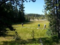
We went through a meadow, crossed the Firehole River on a bridge, and then walked through some lightly forested areas. Here, Susan and Nancy appear to be hiding behind very little trees, but really they're just trying to get a better look at a thermal area.

For quite a ways we had nice views through the trees.

We began to pass campsites, and we stopped at the third one to eat lunch. It was by the river, and I thought it was quite pleasant. We ate and then moved on. Over the course of the 10.5 miles that day, it rained on us some, and we had four periods of lightening and thunder. There was even hail or sleet for a little while. Between the rain and the fact that we were trying to get to our site, I didn't get many pictures. This is a fairly representative picture of the trail, though. It was well maintained (Thanks trail crew!) and nicely graded.

The trail down to our campsite (8R5) from the Shoshone Lake Trail was about half a mile long. We had a nice view of Shoshone Lake before we got to the campsite. The little tree on the peninsula that juts out into the lake, that's a little spit of land that's right below our campsite.

We got to our campsite in the late afternoon, hung our food bags, set up our tents, and ate. As the sun set, it got cool fast, and we all disappeared into our tents.

Day 2 was a layover day. The plan was to hike about a mile to the Shoshone Geyser Basin, and explore. First, Rex and Susan made an awesome breakfast of scrambled eggs (Egg Beaters carried in frozen, but thawed by morning) and coffee-press coffee. Mmmmm.
After breakfast, we donned our day packs and headed back up the trail. I imagined that the hike back to the trail would seem shorter, since I was no longer tired from the hike in to the campsite. Umm, yeah. It still seemed like it was a loooooong ways. According to Rex's pedometer, it was .8 mile from the campsite to the turnoff to the geyser basin. The first thing you did as you entered the geyser basin was to walk the plank. Er, the boardwalk.

The geyser basin didn't give up any secrets right away, though. We were happy looking at the lay of the geyser basin, and a pretty moss garden on the hillside.


Next, we came to either an old geyser or a current geyser that wasn't really doing anything. The trail was not marked, but it was pretty clear where people had walked before us. When I picked up the permit we were warned to stay on the trail, and it led us to a number of interesting thermal features. The trail was maybe half a mile long in the thermal area, maybe more, and we saw a lot of bubbling, churning and colorful features.


Hey look, a self portrait!


As you see, the trail goes right next to thermal features.


We wondered, if a body in one of these pools dissolves, why did that log not do the same?


We came to what seemed like the end of the thermal area, but kept going, hoping to see another feature that was supposed to be a bit further on the trail. We got some views of Shoshone Lake, waaaaaay on the other side of some marshy areas.

We didn't see where the trail clearly went, and we got to a stream crossing, so we opted to turn back.

We wanted to eat lunch. The place we had thought would be a good rest stop was occupied by a family when we got back, so we went on. Rex spotted some wildlife--a sage lizard, the only lizard in Yellowstone (according to the Yellowstone website, anyway).

We started hiking back into the thermal area. Rex found a spot where we could all sit, so we did, and Nancy served lunch. It was the second great meal of the day, and we enjoyed it while sitting about 10 feet from some old geyser.

It turned out it wasn't "some old geyser," though. It's name was Minuteman, and while we hadn't seen it do *anything* on our way through the geyser basin, after we had made ourselves at home on a rise facing the geyser, it started to sputter and eventually went off.

Minuteman went off twenty times while we ate lunch, packed up, and started to depart. The water shot about 10-15 feet high every few minutes, hence the name Minuteman.
We watched it go off repeatedly. It was our own personal show.
.jpg")
We began to watch the outflow, and the pool of blue water at the base of the geyser. It would telegraph when an eruption was about to happen.

Eventually, we started back.
From a different direction, the features looked different.


The others wanted to take the side trail to where people in boats could land to visit the geyser basin. I had a higher priority--I wanted a nap. So they went to the boat landing and I headed back to camp.
One last look of the geyser basin.

Back at camp, there were some kayakers on that little bit of land that juts out onto the lake. So I went and talked to them for a bit. They had no idea there was a campsite there. One asked how we knew it was a campsite, since it didn't have a big sign that could be seen from the water. So I explained that this was a walk-in site, not a water site, and the sign for us was on the trail. He looked baffled. Where was the trail? So I pointed to the ridge and tried to explain. They felt bad that they had invaded our campsite, but I didn't want them to feel bad, I just wanted to know about their kayaking trip. They had had to pull their boats about a mile up the Lewis Channel. Hmmm. That might be fun... someday. In the mean time, I think I'll stick to backpacking.
I did get my nap in. I was a happy camper.")
There were more boats at, or headed to, the landing site than the kayakers I had talked to. I watched one blue canoe with a man and a boy. The boy was maybe 10, and wasn't really contributing in a meaningful way to the propulsion of the boat. We all have to learn, but I was really floored watching the man--he was gouging at the water with his paddle, and trying to force the canoe to go where he wanted it to. For a number of strokes, they were both pulling on the same side at the same time, and I was really nervous they were going to go over. Eventually, the man got the boat to the far shore, and they disembarked and I assume they went off to see the geyser basin. After an hour or more, the blue canoe, an aluminum canoe, and another canoe were the only boats still at the landing spot. The wind had come up, and all I could think of was that little boy getting tossed into the cold lake because the man was not a capable canoeist. We all talked, and thought that maybe if Rex talked to them, they might be willing to pull in rather than try to go further into the lake (The paddle to our campsite was relatively sheltered). We didn't have a lot to offer, but stopping at our site would beat getting dumped into the lake. At least that's what we thought. All three adult canoeists refused the offers. We hoped that we wouldn't read about canoeing disasters in the newspaper when we got back. (We didn't.)
The next day, we were up and packing by 7.
Nancy made oatmeal that was really good. (I think it was really good because it had as much fruit and nuts as it did oatmeal.) And Susan again handled the coffee.


By 9 am, we were on the trail.
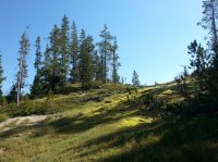
Since we had miles to make I didn't stop to take pictures very often. This is a notable spot, even though it looks pretty unassuming. The spot of sunshine on the trail is Grant Pass, the high point of our hike, and where we crossed the Continental Divide.

Here we are, back at Lone Star. It looks much sunnier on this day!

We stopped at the pull off on the park's loop road, where you can see Shoshone Lake from a distance. Waaaaaay far away, you can see a little teeny bit of blue, right behind the trees.
We made it over there. And back.

We left from the Lone Star Geyser trailhead. The cast of characters is Susan, Nancy, Rex and me. So far, so good. We've managed to get out of our cars and put on our packs. And, we're still smiling!
The trail to the Lone Star Geyser is an old road. Rex and I chatted a little as we hiked down the road, and he told me that when he came to Yellowstone as a kid, his family drove on this road to see the geyser. Cool. Currently, you can hike or ride a bicycle to get to the geyser. Lone Star Geyser goes off about every three hours, and if you're there to see it, you're supposed to write down the day and time in the book that's in the viewing area, so others have an idea of how long it will be before it goes off again.
The trail is pretty level for the two and a half miles to Lone Star Geyser. It goes up a little, and down a little, but mostly, it's just a narrow road in the woods. For some of the road, we were beside the Firehole River, which added variety. We were all a little worried about making it the ten-ish miles to our campsite, so we moved along pretty quickly here.
Our first waypoint was the Lone Star Geyser. The first of our group to arrive (i.e. not me) asked the other visitors if it had erupted recently, and got some mixed answers. Apparently, it had gone off, and some folks were leaving. Well, that was disappointing, but we decided to stop for a little bit, anyway.
There was a couple that seemed to think it might be about to go off again. There was steam coming out the vent. They perched themselves on a log, front and center. They were on their honeymoon. It was kind of sweet.
Sure enough, in a few minutes, the geyser erupted. It was a pretty nice display, made nicer by the fact that only a few people were around to see it, and we got to see it from up close. You may notice that the clouds were looking a little menacing, and shortly after Lone Star stopped its show, the heavens opened and the rain fell and there was lightening and thunder. We put on our rain gear, and just hunkered under the fairly small trees where we were. In a bit, the thunder and lightening stopped and the rain slowed and we started hiking again.
We went through a meadow, crossed the Firehole River on a bridge, and then walked through some lightly forested areas. Here, Susan and Nancy appear to be hiding behind very little trees, but really they're just trying to get a better look at a thermal area.
For quite a ways we had nice views through the trees.
We began to pass campsites, and we stopped at the third one to eat lunch. It was by the river, and I thought it was quite pleasant. We ate and then moved on. Over the course of the 10.5 miles that day, it rained on us some, and we had four periods of lightening and thunder. There was even hail or sleet for a little while. Between the rain and the fact that we were trying to get to our site, I didn't get many pictures. This is a fairly representative picture of the trail, though. It was well maintained (Thanks trail crew!) and nicely graded.
The trail down to our campsite (8R5) from the Shoshone Lake Trail was about half a mile long. We had a nice view of Shoshone Lake before we got to the campsite. The little tree on the peninsula that juts out into the lake, that's a little spit of land that's right below our campsite.
We got to our campsite in the late afternoon, hung our food bags, set up our tents, and ate. As the sun set, it got cool fast, and we all disappeared into our tents.
Day 2 was a layover day. The plan was to hike about a mile to the Shoshone Geyser Basin, and explore. First, Rex and Susan made an awesome breakfast of scrambled eggs (Egg Beaters carried in frozen, but thawed by morning) and coffee-press coffee. Mmmmm.
After breakfast, we donned our day packs and headed back up the trail. I imagined that the hike back to the trail would seem shorter, since I was no longer tired from the hike in to the campsite. Umm, yeah. It still seemed like it was a loooooong ways. According to Rex's pedometer, it was .8 mile from the campsite to the turnoff to the geyser basin. The first thing you did as you entered the geyser basin was to walk the plank. Er, the boardwalk.
The geyser basin didn't give up any secrets right away, though. We were happy looking at the lay of the geyser basin, and a pretty moss garden on the hillside.
Next, we came to either an old geyser or a current geyser that wasn't really doing anything. The trail was not marked, but it was pretty clear where people had walked before us. When I picked up the permit we were warned to stay on the trail, and it led us to a number of interesting thermal features. The trail was maybe half a mile long in the thermal area, maybe more, and we saw a lot of bubbling, churning and colorful features.
Hey look, a self portrait!
As you see, the trail goes right next to thermal features.
We wondered, if a body in one of these pools dissolves, why did that log not do the same?
We came to what seemed like the end of the thermal area, but kept going, hoping to see another feature that was supposed to be a bit further on the trail. We got some views of Shoshone Lake, waaaaaay on the other side of some marshy areas.
We didn't see where the trail clearly went, and we got to a stream crossing, so we opted to turn back.
We wanted to eat lunch. The place we had thought would be a good rest stop was occupied by a family when we got back, so we went on. Rex spotted some wildlife--a sage lizard, the only lizard in Yellowstone (according to the Yellowstone website, anyway).
We started hiking back into the thermal area. Rex found a spot where we could all sit, so we did, and Nancy served lunch. It was the second great meal of the day, and we enjoyed it while sitting about 10 feet from some old geyser.
It turned out it wasn't "some old geyser," though. It's name was Minuteman, and while we hadn't seen it do *anything* on our way through the geyser basin, after we had made ourselves at home on a rise facing the geyser, it started to sputter and eventually went off.
Minuteman went off twenty times while we ate lunch, packed up, and started to depart. The water shot about 10-15 feet high every few minutes, hence the name Minuteman.
We watched it go off repeatedly. It was our own personal show.
We began to watch the outflow, and the pool of blue water at the base of the geyser. It would telegraph when an eruption was about to happen.
Eventually, we started back.
From a different direction, the features looked different.
The others wanted to take the side trail to where people in boats could land to visit the geyser basin. I had a higher priority--I wanted a nap. So they went to the boat landing and I headed back to camp.
One last look of the geyser basin.
Back at camp, there were some kayakers on that little bit of land that juts out onto the lake. So I went and talked to them for a bit. They had no idea there was a campsite there. One asked how we knew it was a campsite, since it didn't have a big sign that could be seen from the water. So I explained that this was a walk-in site, not a water site, and the sign for us was on the trail. He looked baffled. Where was the trail? So I pointed to the ridge and tried to explain. They felt bad that they had invaded our campsite, but I didn't want them to feel bad, I just wanted to know about their kayaking trip. They had had to pull their boats about a mile up the Lewis Channel. Hmmm. That might be fun... someday. In the mean time, I think I'll stick to backpacking.
I did get my nap in. I was a happy camper.
There were more boats at, or headed to, the landing site than the kayakers I had talked to. I watched one blue canoe with a man and a boy. The boy was maybe 10, and wasn't really contributing in a meaningful way to the propulsion of the boat. We all have to learn, but I was really floored watching the man--he was gouging at the water with his paddle, and trying to force the canoe to go where he wanted it to. For a number of strokes, they were both pulling on the same side at the same time, and I was really nervous they were going to go over. Eventually, the man got the boat to the far shore, and they disembarked and I assume they went off to see the geyser basin. After an hour or more, the blue canoe, an aluminum canoe, and another canoe were the only boats still at the landing spot. The wind had come up, and all I could think of was that little boy getting tossed into the cold lake because the man was not a capable canoeist. We all talked, and thought that maybe if Rex talked to them, they might be willing to pull in rather than try to go further into the lake (The paddle to our campsite was relatively sheltered). We didn't have a lot to offer, but stopping at our site would beat getting dumped into the lake. At least that's what we thought. All three adult canoeists refused the offers. We hoped that we wouldn't read about canoeing disasters in the newspaper when we got back. (We didn't.)
The next day, we were up and packing by 7.
Nancy made oatmeal that was really good. (I think it was really good because it had as much fruit and nuts as it did oatmeal.) And Susan again handled the coffee.
By 9 am, we were on the trail.
Since we had miles to make I didn't stop to take pictures very often. This is a notable spot, even though it looks pretty unassuming. The spot of sunshine on the trail is Grant Pass, the high point of our hike, and where we crossed the Continental Divide.
Here we are, back at Lone Star. It looks much sunnier on this day!
We stopped at the pull off on the park's loop road, where you can see Shoshone Lake from a distance. Waaaaaay far away, you can see a little teeny bit of blue, right behind the trees.
We made it over there. And back.
Attachments
Last edited: