Yellowstone Lottery 2025

CodyL

Member
Joined
Jan 23, 2018
Messages
120
Well. 3 years in a row of a bad draw for our group! Soonest access day for us is April 18th. Each year has been a disappointment on results day, but somehow everything seems to work out and we end up with a great trip anyway! Hope everyone else fared better!!
 
I got 1st. Very, very lucky. But I have a question for you.

I was thinking of doing a 3-day, 2-night loop hike in the Gallatin area. My plan was to start from Indian Creek TH, cross Bighorn Pass, and camp at Gallatin River (WB1). The next day, I would connect with Fawn Pass Trail, then follow Fan Creek, and finally take the Sportsman Lake Trail to Sportsman Lake Camp. On the last day, I planned to head toward Electric Peak Pass and exit through Glen Creek TH, where we would have parked the car.


That was the plan, but after checking the recreation.gov website and looking at the backcountry campsites, I noticed warnings—specifically at Sportsman Lake—stating that the Glen Creek and Snow Pass trails will be closed in 2025 (this is the only place where I’ve seen this information). So, how can I exit to the Mammoth-Norris road?
I don't know the details of the closure, but could you use Sepulcher Mountain TH instead of Glen Creek TH?
 
Once again Recreation.gov is laughing all the way to the bank with my $10 as I did not get selected for a spot.

I think my e-mail must be flagged and is on some sort of "automatic no" list.

Trying to plan a September trip -- one of the guys coming along signed in and received an April 20th date, brother in law Patrick (also invited along) registered with rec.gov but never entered the lottery so. . . . :rolleyes:

We will make something work. May just have to target the path less travelled.
 
I got 1st. Very, very lucky. But I have a question for you.

I was thinking of doing a 3-day, 2-night loop hike in the Gallatin area. My plan was to start from Indian Creek TH, cross Bighorn Pass, and camp at Gallatin River (WB1). The next day, I would connect with Fawn Pass Trail, then follow Fan Creek, and finally take the Sportsman Lake Trail to Sportsman Lake Camp. On the last day, I planned to head toward Electric Peak Pass and exit through Glen Creek TH, where we would have parked the car.


That was the plan, but after checking the recreation.gov website and looking at the backcountry campsites, I noticed warnings—specifically at Sportsman Lake—stating that the Glen Creek and Snow Pass trails will be closed in 2025 (this is the only place where I’ve seen this information). So, how can I exit to the Mammoth-Norris road?

Are these trailheads closed due to road construction or trailhead reconstruction? Anyway, @TheMountainRabbit 's Sepulcher Trailhead is the best option for an alternative. If for some reason that trailhead is affected too, then you could use the Bighorn Pass - Indian Creek Trailhead and use the old Howard Eaton Trail to hike north to intersect with the Glen Creek Trail.

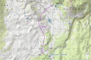
Here is a map of where the trail runs on the ground. It would add 3.8 miles to your first and last days.

Howard_Eaton_Trail_Glen_Creek_to_Indian_Creek.jpg

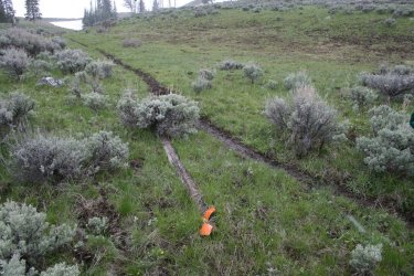
Now knowing all of this, the old trail is easier to pick up on the Glen Creek Trail side than the Indian Creek side, but even if you can't locate the trail right off the bat, the off-trail you would be doing is pretty easy. There are old downed trail markers along the way once on the old trail.

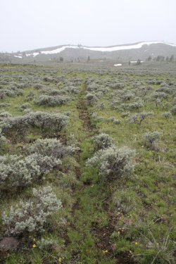
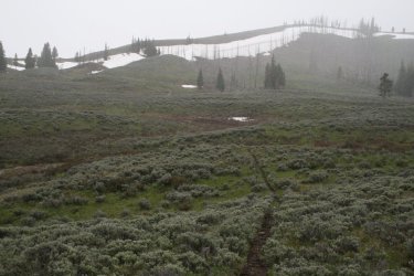
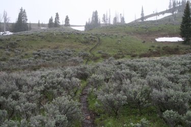
The terrain looks like this -
Old Howard Eaton Trail between Glen Creek and Indian Creek
02.jpg
03.jpg
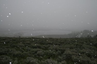
Looking down on Swan Lake for the Howard Eaton Trail
06.jpg
04.jpg
05.jpg
 
Thank you, everyone. I'm from Spain, and I had the recreation.gov app set to Spanish. In certain backcountry campsites in the eastern Gallatin area, it literally says, "Los senderos de Glen Creek y Snow Pass estarán CERRADOS en 2025." The word "sendero" translates to "trail" in English. However, if you switch the app to English, the notice says, "Glen Creek and Snow Pass Trailheads are CLOSED in 2025." And, my friend, "trail" and "trailhead" are not the same thing.


Anyway, I also asked the Backcountry office about this yesterday, and they replied with the following:
"Hello Alejandro: You will still be able to come out in Mammoth but coming out from the Sepulcher Mountain trail, or coming down Snow Pass and connecting on the Howard Eaton trail behind the Mammoth Terraces. I hope that helps answer your question."
 
Once again Recreation.gov is laughing all the way to the bank with my $10 as I did not get selected for a spot.

I think my e-mail must be flagged and is on some sort of "automatic no" list.

Trying to plan a September trip -- one of the guys coming along signed in and received an April 20th date, brother in law Patrick (also invited along) registered with rec.gov but never entered the lottery so. . . . :rolleyes:

We will make something work. May just have to target the path less travelled.
I suspect if you want to do that boundary creek one.... That the harder site to get would be at dunada. Probly get walk in for others if you're a little flexibke
 
Are these trailheads closed due to road construction or trailhead reconstruction? Anyway, @TheMountainRabbit 's Sepulcher Trailhead is the best option for an alternative. If for some reason that trailhead is affected too, then you could use the Bighorn Pass - Indian Creek Trailhead and use the old Howard Eaton Trail to hike north to intersect with the Glen Creek Trail.

Here is a map of where the trail runs on the ground. It would add 3.8 miles to your first and last days.

View attachment 140431

Now knowing all of this, the old trail is easier to pick up on the Glen Creek Trail side than the Indian Creek side, but even if you can't locate the trail right off the bat, the off-trail you would be doing is pretty easy. There are old downed trail markers along the way once on the old trail.

The terrain looks like this -
Old Howard Eaton Trail between Glen Creek and Indian Creek
View attachment 140432
View attachment 140433
Looking down on Swan Lake for the Howard Eaton Trail
View attachment 140436
View attachment 140434
I'm seriously considering this alternative you're suggesting, @scatman. This way, I could complete a true loop hike and forget about hitchhiking. The idea would be to finish my backpacking route with that section. Do you have the coordinates or a GPX file of that old trail?
 
I don't have a GPX file for you @Ymyr , but the old trail is easy enough to be seen on Google Earth. It sounds like you will be coming back down the Glen Creek Trail, and if so then the old Howard Eaton is easy to pick up.

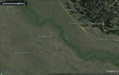
Here is a shot from Google Earth to help you locate the trail.

Howard_Eaton_Glen_Creek.jpg

As you make your way down the Glen Creek Trail heading towards the Glen Creek Trailhead, you will intersect with the still maintained Howard Eaton Trail that heads north towards Mammoth. Just take a right at the junction and head off into the sagebrush and you will eventually run into the old trail. It actually goes straight through the backcountry information sign that used to be located at the trail junction. After crossing Glen Creek the old trail should cross the old wagon road before heading off to the west of Swan Lake.

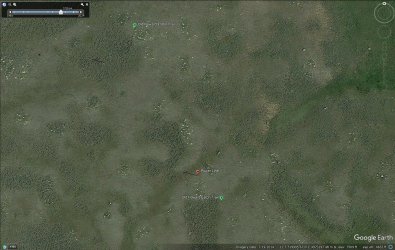
As you get closer to the Indian Creek side of the trail, you will run into a powerline. At this point, you can just follow the power poles all the way to the Bighorn Pass Trail. The actual Howard Eaton Trail parallels the powerline to the east, but as I mentioned before the old trail gets a little tricky to follow as you approach the Gardner River and Indian Creek, so unless you are an old trail perfectionist like me :), it might be easier to follow the power poles. Once at the Bighorn Pass Trail, hang a right and it will lead you to the Trailhead.

Howard_Eaton_Power_Line.jpg
UTM Coordinates for the power pole where you turn off the old trail and start following the powerline corridor are UTM Zone 12, 519996 E, 4973157 N

Be sure and check it out on Google Earth and you'll be fine.
 
Last edited:

Don't like ads? Become a BCP Supporting Member and kiss them all goodbye. Click here for more info.

Back
Top