A month or so ago, I asked if anyone wanted to join me for a leisurely trip into the Bechler. It didn't take long before I got a response from Eric and Kevin, and after a few questions, things were set. On the appointed morning we met at the Grant backcountry office and were soon on our way to the trailhead.
We were to go from the Lonestar Trailhead to a site just beyond Lonestar Geyser, then to a site at the top of the divide, then down to a site beside Albright Falls. After a layover day, we were to go back up to the second site, then have a final site just before Lonestar Geyser, again, and finally, out.
We started out next to the Firehole River. The trail's a popular dayhike, so there were plenty of people mixed in with us. There was a family that was large and hardly separated and at one point they asked us how far it was to the geyser. Someone answered a couple of miles and, well, they disappeared.

We came to the geyser, and there were a bunch of people. A couple told us that the geyser had just gone off. This geyser usually has a first eruption that's sort of small, and then a bigger eruption. We weren't sure if this couple would know a big eruption from a small eruption, but opted to head on anyway. We had a bit more than a mile to go, and covered it relatively quickly.

The campsite had a stream running through it. Across the trail was a pit toilet and a thermal area.
We set up camp, and talked, getting to know each other. In the early evening, we were joined by 2 CDT hikers. They mostly did their chores and went to sleep, but I did have a nice chat with the lady, who had hiked the AT.
The next day we got up early, hoping to get out of camp relatively early, but the flies on our tents were drenched, and we waited a bit for the sun to do its thing. Two rangers came in, and cleaned out the firering and chatted.
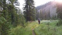
We ended up leaving about an hour after we had intended to leave. We hiked up to Grant Pass and the Continental Divide and turned onto the Becher River Trail. The first few miles had open woods and small meadows. Then it became steeper, and went through pine forests. Fir forests, actually. I didn't get many picture's because we were moving along. Mind you, I didn't move fast, but I didn't stop for pictures, mostly.
The climb was not horrid, but there were almost no flat sections once it started. We separated (I took my rightful place at the back). Eventually, I came upon Kevin sitting on a log, having some lunch. I picked my own log and joined him.

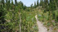
We probably only spent 15 minutes eating and chatting and were on our way. In just a few minutes we came to a spot on the trail where Eric left us a message--writteen in littl sticks, it told us he had left that spot about half an hour before we had gotten there. We moved on, getting to the top, and beginning a mile of lititle ups and downs. It was beautiful. I referred to it as Obsidian Gardens, as there was a lot of Obsidian, and all kinds of flowers.

I was last to make it to camp (a well developed habit of mine), but quite happy to get there. It overlooked a big meadow, and a mini canyon, from which we got our water. There were LOTS of mosquitoes.


We set up camp. I'm thankful that Kevin watched me try to toss my bear rope over the first bear pole, and while he laughed at my attempt, he also grabbed my rope and tossed it over for me, for the rest of the trip. (I CAN toss my rope over the pole, but somrtimes it takes a number of tries.) Eric went and filled my water bag. (I must have looked mostly dead.) I got up my tent and ate and went and looked out at the meadow. It was beautiful.

That night, you could hear the incessant whining of mosquitoes. I hadn't heard it that bad since the Boundary Waters.
The next day we began our descent into the upper Bechler. We first had to cross the meadow.

Eric set up a camera on a tripod and got some video, that he may post here. We had to splash through the stream, then walk through the grass, and do about a hundred yards through marshy grass (thwick, thwick, thwick) before coming out on solid ground, climbing the little ridge and starting down.
For maybe a mile it was gentle, but mostly down, and then the downward trend became serious. We were in firs, and the trail had enough rocks to make you pay attention lest you slide.
I caught up to them at a campsite. There was a creek, but the bridge was out. The livestock ford was obvious. I'm (kind of) scared of the water, but this was a good place to cross. I could see the bottom, and it was all rock. The water was nearly knee deep, but I managed fine. We continued along the trail quickly coming to the turn off for Twister Falls. We headed down. I got nervous about the slope and the loose gravel and never really got a good view of it. Hopefully Kevin or Eric will post a picture.
Back on the trail, we separated again. the descent was stiff. Eventually, I came to another campsite, and could see some meadows on the other side of what was now a river. There was a cliff on the facing side, which I thought looked like Caldera. Whatever it was, it was impressive.

(This was near the top.)

(The foundation for the bridge that wasn't.)

(A stream.)
I saw the guys below, and then saw that I had to cross a very active stream, on a log--flattened on top, and turned into a bridge. It was pretty high over the water. I was really careful, and got across without any problem. The trail splashed through run off from some thermal pools.

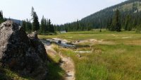
The trail entered a meadow along the river, with thermal features. Yellowstone is filled with thermal features, but not that you can see without a zillion people alongside you. Here, we had them to ourselves. What a treat.


Kevin sat and looked at the pool.
Next, we found our campsite. From the kitchen, we had a glorious view of 200 foot high Albright Falls.

Not bad decorating.
Eric had decided he wanted to take on the challenge of hiking the entire 16-ish miles back to the car the next day. So he made preparations for that. He decided to get up at five, and leave at 6. I said my good byes, as I wasn't sure I'd be up that early on a nonhiking day.
I did end up getting to the kitchen area just as he was leaving. Farewells were said and he was off.
One interesting thing about this site and the previous site were the pit toilets. They were plywood with a hole cut in them. We thought they looked like a cut out of the national park emblem.

Kevin and I talked and looked at the waterfall and drank coffee, and eventually had lunch and decided to walk down to the first ford of the Bechler River. That was the point I had decided I wouldn't pass when I made the reservation request.

There were lots of flowers.

And all kinds of impressive water scenery.
We headed back. I turned into camp and took a nap, while Kevin explored a little.
Dinner was interrupted by a short thunderstorm.
It was maybe 7 pm when we were visited by a ranger, who wanted.to clean our firepit. It was a no fire site, so that was really fast. He talked to us for a few minutes, then took his shovel and left.
We decided to leave at 8 the next morning.
It ended up being a bit after that, but not a lot. We moved more slowly on this day, wanting to take pictures, and ration our energy for the climb ahead. At least those were my thoughts. Here are some photos from that day...


We didn't see any wildlife, so this is my brother in law's dog. He's only wild if you are a toy with a squeaker in it. Then he's a holy terror.


We spent the night at our previous campsite. This time it was windy and we went to our tents early. The next day was to be our longest day, at about 8 miles.
We left at about 8, after a group of boys noisily crossed the meadow.
We stopped for a snack and while talking, decided to hike out, rather than stay one last night, at least if we still felt OK when we got to our site. That would mean an 11+ mile day.
We hiked through the Obsidian Garden, over Grant Pass and the Continental Divide, and Kevin got a good look at the geyser going off, while I saw steam. The last couple of miles were harder, but we got to our vehicles in time to order cheeseburgers by 3:30.
Best. Cheeseburger. Ever.


What IS this stuff?

We were to go from the Lonestar Trailhead to a site just beyond Lonestar Geyser, then to a site at the top of the divide, then down to a site beside Albright Falls. After a layover day, we were to go back up to the second site, then have a final site just before Lonestar Geyser, again, and finally, out.
We started out next to the Firehole River. The trail's a popular dayhike, so there were plenty of people mixed in with us. There was a family that was large and hardly separated and at one point they asked us how far it was to the geyser. Someone answered a couple of miles and, well, they disappeared.
We came to the geyser, and there were a bunch of people. A couple told us that the geyser had just gone off. This geyser usually has a first eruption that's sort of small, and then a bigger eruption. We weren't sure if this couple would know a big eruption from a small eruption, but opted to head on anyway. We had a bit more than a mile to go, and covered it relatively quickly.
The campsite had a stream running through it. Across the trail was a pit toilet and a thermal area.
We set up camp, and talked, getting to know each other. In the early evening, we were joined by 2 CDT hikers. They mostly did their chores and went to sleep, but I did have a nice chat with the lady, who had hiked the AT.
The next day we got up early, hoping to get out of camp relatively early, but the flies on our tents were drenched, and we waited a bit for the sun to do its thing. Two rangers came in, and cleaned out the firering and chatted.
We ended up leaving about an hour after we had intended to leave. We hiked up to Grant Pass and the Continental Divide and turned onto the Becher River Trail. The first few miles had open woods and small meadows. Then it became steeper, and went through pine forests. Fir forests, actually. I didn't get many picture's because we were moving along. Mind you, I didn't move fast, but I didn't stop for pictures, mostly.
The climb was not horrid, but there were almost no flat sections once it started. We separated (I took my rightful place at the back). Eventually, I came upon Kevin sitting on a log, having some lunch. I picked my own log and joined him.
We probably only spent 15 minutes eating and chatting and were on our way. In just a few minutes we came to a spot on the trail where Eric left us a message--writteen in littl sticks, it told us he had left that spot about half an hour before we had gotten there. We moved on, getting to the top, and beginning a mile of lititle ups and downs. It was beautiful. I referred to it as Obsidian Gardens, as there was a lot of Obsidian, and all kinds of flowers.
I was last to make it to camp (a well developed habit of mine), but quite happy to get there. It overlooked a big meadow, and a mini canyon, from which we got our water. There were LOTS of mosquitoes.
We set up camp. I'm thankful that Kevin watched me try to toss my bear rope over the first bear pole, and while he laughed at my attempt, he also grabbed my rope and tossed it over for me, for the rest of the trip. (I CAN toss my rope over the pole, but somrtimes it takes a number of tries.) Eric went and filled my water bag. (I must have looked mostly dead.) I got up my tent and ate and went and looked out at the meadow. It was beautiful.
That night, you could hear the incessant whining of mosquitoes. I hadn't heard it that bad since the Boundary Waters.
The next day we began our descent into the upper Bechler. We first had to cross the meadow.
Eric set up a camera on a tripod and got some video, that he may post here. We had to splash through the stream, then walk through the grass, and do about a hundred yards through marshy grass (thwick, thwick, thwick) before coming out on solid ground, climbing the little ridge and starting down.
For maybe a mile it was gentle, but mostly down, and then the downward trend became serious. We were in firs, and the trail had enough rocks to make you pay attention lest you slide.
I caught up to them at a campsite. There was a creek, but the bridge was out. The livestock ford was obvious. I'm (kind of) scared of the water, but this was a good place to cross. I could see the bottom, and it was all rock. The water was nearly knee deep, but I managed fine. We continued along the trail quickly coming to the turn off for Twister Falls. We headed down. I got nervous about the slope and the loose gravel and never really got a good view of it. Hopefully Kevin or Eric will post a picture.
Back on the trail, we separated again. the descent was stiff. Eventually, I came to another campsite, and could see some meadows on the other side of what was now a river. There was a cliff on the facing side, which I thought looked like Caldera. Whatever it was, it was impressive.
(This was near the top.)
(The foundation for the bridge that wasn't.)
(A stream.)
I saw the guys below, and then saw that I had to cross a very active stream, on a log--flattened on top, and turned into a bridge. It was pretty high over the water. I was really careful, and got across without any problem. The trail splashed through run off from some thermal pools.
The trail entered a meadow along the river, with thermal features. Yellowstone is filled with thermal features, but not that you can see without a zillion people alongside you. Here, we had them to ourselves. What a treat.
Kevin sat and looked at the pool.
Next, we found our campsite. From the kitchen, we had a glorious view of 200 foot high Albright Falls.
Not bad decorating.
Eric had decided he wanted to take on the challenge of hiking the entire 16-ish miles back to the car the next day. So he made preparations for that. He decided to get up at five, and leave at 6. I said my good byes, as I wasn't sure I'd be up that early on a nonhiking day.
I did end up getting to the kitchen area just as he was leaving. Farewells were said and he was off.
One interesting thing about this site and the previous site were the pit toilets. They were plywood with a hole cut in them. We thought they looked like a cut out of the national park emblem.
Kevin and I talked and looked at the waterfall and drank coffee, and eventually had lunch and decided to walk down to the first ford of the Bechler River. That was the point I had decided I wouldn't pass when I made the reservation request.
There were lots of flowers.
And all kinds of impressive water scenery.
We headed back. I turned into camp and took a nap, while Kevin explored a little.
Dinner was interrupted by a short thunderstorm.
It was maybe 7 pm when we were visited by a ranger, who wanted.to clean our firepit. It was a no fire site, so that was really fast. He talked to us for a few minutes, then took his shovel and left.
We decided to leave at 8 the next morning.
It ended up being a bit after that, but not a lot. We moved more slowly on this day, wanting to take pictures, and ration our energy for the climb ahead. At least those were my thoughts. Here are some photos from that day...
We didn't see any wildlife, so this is my brother in law's dog. He's only wild if you are a toy with a squeaker in it. Then he's a holy terror.
We spent the night at our previous campsite. This time it was windy and we went to our tents early. The next day was to be our longest day, at about 8 miles.
We left at about 8, after a group of boys noisily crossed the meadow.
We stopped for a snack and while talking, decided to hike out, rather than stay one last night, at least if we still felt OK when we got to our site. That would mean an 11+ mile day.
We hiked through the Obsidian Garden, over Grant Pass and the Continental Divide, and Kevin got a good look at the geyser going off, while I saw steam. The last couple of miles were harder, but we got to our vehicles in time to order cheeseburgers by 3:30.
Best. Cheeseburger. Ever.
What IS this stuff?
Attachments

Last edited:


")