Eugene
Member
- Joined
- Mar 13, 2012
- Messages
- 141
Introduction:
Four of us had planned to do Arch Canyon but decided to try and do Woodenshoe Canyon instead. We flew into Albuquerque on Monday Apr 21 and proceeded to drive to Blanding and then the trailhead. The road to the trailhead we used is off of highway 95 and then off the Natural Bridges road. Although the road was gravel it seemed to be in good shape. About 3/4 way up to Bears Ears we had a major flat. Evidently a rock punctured the right rear tire. We then put on the spare and decided to head back down towards Blanding and camped at Combs wash for the night and then to Blanding the next morning to get the tire repaired. Of course the tire was ruinied and no new tires were available so we put a used tire on the spare and continued to the trailhead without incident. (See end for more tire woes!!) At 8000 ft the weather was quite brisk but it was a sunny day. This is my first trip report on Backcountry Post so if anything is not proper please let me know.
Woodenshoe Trailhead:
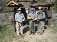
Since it was late already when we hit the trailhead (Tues) we proceeded to hike to Cherry Canyon where our sources said water would be available and camp for the night. There are a couple of nice camping areas at this point be they a little sandy (wind was a bit of a factor and hence the sand was a bit of a nuisance). Water was readily available (suspect in a few weeks in might be getting scarce). The book we had said Cherry was about 4 miles down canyon (about 1000 ft down). However my GPS showed it to be more like 5 miles. The grade was fairly gradual but walking up would prove to be a bit more exhausting.
Cherry Canyon Campground:
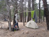
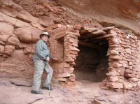
On Wednesday morning we proceeded down canyon and found our first ruin about 1 mile down canyon on a wall on the right. It appeared to be a lone ruin but was easily accessible.
Ruin 1 mile below Cherry Canyon:
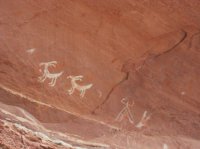
Pictographs above ruin:
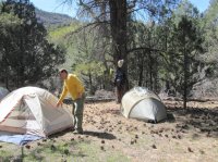
We then proceeded down canyon to try and find some more extensive ruins noted in our guidebook. The book stated that these ruins would be down canyon off a canyon named "Keystone Arch Canyon". Our map did not have a named canyon but from the description we did identify the canyon about 3 or so miles below Cherry. We did explore further below but water appeared to become more difficult to find so we opted to camp at this canyon for the night and planned to spend the next morning bushwacking up the canyon and along the south facing side to attempt to find the reported ruins.
Wednesday campsite:
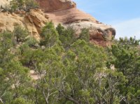
Thursday morning was quite cold. In fact our water bottles and dromes were nearly frozen solid. However there was little wind so it was bearable. We proceeded up trail a bit and then started exploring the side canyon for ruins. We had done a bit the night before and thought we had spotted some but were not sure (would have helped to have binoculars for this trip - I had left mine in the car to reduce weight). After bushwacking and scrambling up several hundred feel we finally got a good view of some ruins still way up the cliffs. These all appeared to be inaccessible without some real technical climbing so we opted for long distance pictures.
Ruins:
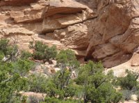
There are ruins just below the overhang upper right
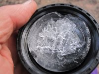
Just to show it was cold this morning (ice on drom lid)
We then proceeded back to Cherry for Thursday night camp as we needed to be out by late morning Friday for the long drive back to Albuquerque. Thursday night again was quite cool and water was iced Friday morning. We then got and early start for the climb out to Woodenshoe TH. As one would expect walking out more clearly demonstrated the 1000 foot or so elevation change from the top a the trailhead but we made the 5 miles and were out a little after 10 am. Now the fun begins!!! We got a about 3/4 the way down and we had 2 - yes 2 flats on the right side and no phone service! Luckily the front tire leak was slower and we managed to get down to the highway and cell service to call a tow truck to be towed in to Blanding. Of course tires were ruined and only tires available were used ones which got us back to Albuquerque - late but we made it.
Trip Summary:
We hiked approximately 25 miles counting all the side trips. The ruin sightings were average but the fact that the last set was somewhat difficult to find made the trip more meaningful. For sure I would not count on water in the canyon late spring or summer as I suspect the water sources will soon dry up. More importantly, even though the road seemed in good condition be sure you have a spare - maybe 2 would be advisable!!!
Four of us had planned to do Arch Canyon but decided to try and do Woodenshoe Canyon instead. We flew into Albuquerque on Monday Apr 21 and proceeded to drive to Blanding and then the trailhead. The road to the trailhead we used is off of highway 95 and then off the Natural Bridges road. Although the road was gravel it seemed to be in good shape. About 3/4 way up to Bears Ears we had a major flat. Evidently a rock punctured the right rear tire. We then put on the spare and decided to head back down towards Blanding and camped at Combs wash for the night and then to Blanding the next morning to get the tire repaired. Of course the tire was ruinied and no new tires were available so we put a used tire on the spare and continued to the trailhead without incident. (See end for more tire woes!!) At 8000 ft the weather was quite brisk but it was a sunny day. This is my first trip report on Backcountry Post so if anything is not proper please let me know.
Woodenshoe Trailhead:

Since it was late already when we hit the trailhead (Tues) we proceeded to hike to Cherry Canyon where our sources said water would be available and camp for the night. There are a couple of nice camping areas at this point be they a little sandy (wind was a bit of a factor and hence the sand was a bit of a nuisance). Water was readily available (suspect in a few weeks in might be getting scarce). The book we had said Cherry was about 4 miles down canyon (about 1000 ft down). However my GPS showed it to be more like 5 miles. The grade was fairly gradual but walking up would prove to be a bit more exhausting.
Cherry Canyon Campground:

On Wednesday morning we proceeded down canyon and found our first ruin about 1 mile down canyon on a wall on the right. It appeared to be a lone ruin but was easily accessible.
Ruin 1 mile below Cherry Canyon:

Pictographs above ruin:

We then proceeded down canyon to try and find some more extensive ruins noted in our guidebook. The book stated that these ruins would be down canyon off a canyon named "Keystone Arch Canyon". Our map did not have a named canyon but from the description we did identify the canyon about 3 or so miles below Cherry. We did explore further below but water appeared to become more difficult to find so we opted to camp at this canyon for the night and planned to spend the next morning bushwacking up the canyon and along the south facing side to attempt to find the reported ruins.
Wednesday campsite:

Thursday morning was quite cold. In fact our water bottles and dromes were nearly frozen solid. However there was little wind so it was bearable. We proceeded up trail a bit and then started exploring the side canyon for ruins. We had done a bit the night before and thought we had spotted some but were not sure (would have helped to have binoculars for this trip - I had left mine in the car to reduce weight). After bushwacking and scrambling up several hundred feel we finally got a good view of some ruins still way up the cliffs. These all appeared to be inaccessible without some real technical climbing so we opted for long distance pictures.
Ruins:

There are ruins just below the overhang upper right

Just to show it was cold this morning (ice on drom lid)

We then proceeded back to Cherry for Thursday night camp as we needed to be out by late morning Friday for the long drive back to Albuquerque. Thursday night again was quite cool and water was iced Friday morning. We then got and early start for the climb out to Woodenshoe TH. As one would expect walking out more clearly demonstrated the 1000 foot or so elevation change from the top a the trailhead but we made the 5 miles and were out a little after 10 am. Now the fun begins!!! We got a about 3/4 the way down and we had 2 - yes 2 flats on the right side and no phone service! Luckily the front tire leak was slower and we managed to get down to the highway and cell service to call a tow truck to be towed in to Blanding. Of course tires were ruined and only tires available were used ones which got us back to Albuquerque - late but we made it.
Trip Summary:
We hiked approximately 25 miles counting all the side trips. The ruin sightings were average but the fact that the last set was somewhat difficult to find made the trip more meaningful. For sure I would not count on water in the canyon late spring or summer as I suspect the water sources will soon dry up. More importantly, even though the road seemed in good condition be sure you have a spare - maybe 2 would be advisable!!!
Last edited:
