Winds from gannett to cirque

Mijita

New Member
Joined
Apr 16, 2022
Messages
4
Hi

I’m looking for some trip planning advice and possible a reality check. I am experienced with backpacking, rock climbing and glacier travel. I am planning to climb gannet with some friends, coming in with horses from dubois, then sending my heavy gear out after what we hope is a successful summit, and continuing southward solo from there. My route is over Blaurock, Indian pass, join up with the cdt, go the the cirque, hike out to big sandy. The mileage is about 60 miles. I am used to doing 15-20 mi a day on an established trail but this may be a very different story. I am thinking 2 days to get from high camp back to the cdt near lake Seneca, 2 days to do the ~ 35 mi to hailey pass, then 2 days in the cirque and out to big sandy.

my questions are
- do these mileages seem reasonable given the terrain? I’m fit but not a superhuman
- given that I’ll be solo, should I be worried about fording some of the rivers, particularly between gannett and rejoining the cdt. Trip is planned for the 3-4 week of July 2022. I read that it is a low snow year
- I had planned to send my heavy gear back and just having microspikes and poles, but could bring crampons and axe. the weight will slow be down though. Thoughts on where I might want that gear between gannett high camp and cirque.

any advice on this trip plan would be greatly appreciated. I will be traveling with an in reach for emergencies and a base weight pack of 14 lbs, probably a little more this trip with the ursack and bear spray.

mijita
The only tough - but very doable - section is going to be Blaurock to Indian; other than that it'll be established trails and reasonably average travel. But if you're doing Gannett already, you'll be fine on Blaurock and Indian is easier.

That said, if you're already over Blaurock my suggestion would be to stay east of the Divide through Alpine Lakes and cross at Hay Pass further south - it'll slow you down a bit, but you seem to have enough cushion in your schedule.

I wouldn't bring anything but microspikes and poles (and probably wouldn't need the microspikes), but since you don't have to decide until after Gannett I think you'll be able to get a good feel for what you're comfortable with. I'm fairly confident in saying that the portion of Blaurock you can see from the Gannett base camp area will probably be the "worst" climb ahead of you.
 
Sounds like a good plan. I suspect that the north side of Blaurock will be hanging on to a good bit of snow yet. But you should be able to scope it out in advance (from the summit of Gannet if nowhere else) and decide then whether you need your axe and crampons or not. Snow-wise, that'll undoubtedly be the crux of the route, so if you don't think you need that equipment for Blaurock, you can send it out with the horses.

Trip sounds great. Enjoy!
 
Thank you so much for the advice. For a moment in the planning I thought I was really biting off too much. I should be relatively acclimated going over blaurock but will be tired from summit day.

ill do some research on hay pass.
 
The only tough - but very doable - section is going to be Blaurock to Indian; other than that it'll be established trails and reasonably average travel. But if you're doing Gannett already, you'll be fine on Blaurock and Indian is easier.

That said, if you're already over Blaurock my suggestion would be to stay east of the Divide through Alpine Lakes and cross at Hay Pass further south - it'll slow you down a bit, but you seem to have enough cushion in your schedule.

I wouldn't bring anything but microspikes and poles (and probably wouldn't need the microspikes), but since you don't have to decide until after Gannett I think you'll be able to get a good feel for what you're comfortable with. I'm fairly confident in saying that the portion of Blaurock you can see from the Gannett base camp area will probably be the "worst" climb ahead of you.
Hi mt rabbit. Just making sure I’m following the hays pass suggestion. Would you follow the southeastern trajectory to hit the top of hays pass trail, or cut more or less the same direction around Indian pass?
 
Blaurock to Indian Pass ........ only real slow portion.

Blaurock past shagrala over Bloody Hell Pass to Camp Lake is no trail. Bloody Hell has Big rock jumping. Very scenic.
 
Hi mt rabbit. Just making sure I’m following the hays pass suggestion. Would you follow the southeastern trajectory to hit the top of hays pass trail, or cut more or less the same direction around Indian pass?
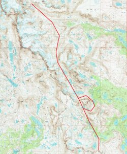
A very general route would be the below - definitely do some additional research, but this is basically the way I've gone.

Like @Bob says, there's lots of rock/boulder hopping - but it's spectacular scenery.

capture.jpg
 
A very general route would be the below - definitely do some additional research, but this is basically the way I've gone.

Like @Bob says, there's lots of rock/boulder hopping - but it's spectacular scenery.

View attachment 109227
Straight-line hiking should become the next big thing. No matter what's in the way, you go right through/over it to stay in a straight line.
 
Straight-line hiking should become the next big thing. No matter what's in the way, you go right through/over it to stay in a straight line.
lol ....... i could never walk that straight of a route......
 
Good suggestions/advice already given above. Indian Pass through Indian Basin out to CDT would indeed be much quicker than Alpine Lakes out to Hay Pass. It's a bit loose/crumbly getting up all the glacial remnants on the east side of Indian but not horrible. I would agree that chances are high that you'll be good with nothing but microspikes and poles for the solo stretches to get over Blaurock, which would likely be the only place they'd be that useful. If you opt for Hay Pass, there is lots and lots and lots of tedious rock hopping, boulder scrambling and a couple minor cliff ledges to navigate and negotiate through Alpine Lakes Basin but if you're comfortable with that kind of stuff solo, it could certainly be worth it, especially when factoring in the additional views from Camp Lake to Golden Lakes and the view out across Dennis Lake just prior to Hay Pass. Absolutely stunning scenery through there as if you won't already get enough of that with the Gannett expedition. The price would be much more energy and time spent doing it that way though. If you do Alpine Lakes Basin, give yourself 5 or 6 hours to get through all that. Of course, beware of weather. If there's chances of thunderstorms, it wouldn't be fun scrambling over all those rocks when wet and with risk of lightning as it's all pretty exposed to the elements around Alpine Lakes. If that becomes an issue/concern, then weather might just make the choice for you. You should have no trouble with going over Indian Pass and picking up established trail the rest of the way from there since the terrain will be much quicker and easier to travel over.
 
Straight-line hiking should become the next big thing. No matter what's in the way, you go right through/over it to stay in a straight line.
Unrelated to the original post but...

That is what this guy has done. Not as much wilderness stuff but still out there trying to cross a country in a straight line. Here's a link to one he did in Norway.

 
Unrelated to the original post but...

That is what this guy has done. Not as much wilderness stuff but still out there trying to cross a country in a straight line. Here's a link to one he did in Norway.

Lol
 
Good suggestions/advice already given above. Indian Pass through Indian Basin out to CDT would indeed be much quicker than Alpine Lakes out to Hay Pass. It's a bit loose/crumbly getting up all the glacial remnants on the east side of Indian but not horrible. I would agree that chances are high that you'll be good with nothing but microspikes and poles for the solo stretches to get over Blaurock, which would likely be the only place they'd be that useful. If you opt for Hay Pass, there is lots and lots and lots of tedious rock hopping, boulder scrambling and a couple minor cliff ledges to navigate and negotiate through Alpine Lakes Basin but if you're comfortable with that kind of stuff solo, it could certainly be worth it, especially when factoring in the additional views from Camp Lake to Golden Lakes and the view out across Dennis Lake just prior to Hay Pass. Absolutely stunning scenery through there as if you won't already get enough of that with the Gannett expedition. The price would be much more energy and time spent doing it that way though. If you do Alpine Lakes Basin, give yourself 5 or 6 hours to get through all that. Of course, beware of weather. If there's chances of thunderstorms, it wouldn't be fun scrambling over all those rocks when wet and with risk of lightning as it's all pretty exposed to the elements around Alpine Lakes. If that becomes an issue/concern, then weather might just make the choice for you. You should have no trouble with going over Indian Pass and picking up established trail the rest of the way from there since the terrain will be much quicker and easier to travel over.
Bloody hell pass not as hard as Alpine
 
Bloody hell pass not as hard as Alpine
I could see that. Little more out of the way, but from seeing Joey's video of it a while back, looks like it'd be a good way to bypass some of that tougher stuff around upper Alpine Lake and still see some pristine seldom visited lakes.
 
  • Like
Reactions: Bob
Good suggestions/advice already given above. Indian Pass through Indian Basin out to CDT would indeed be much quicker than Alpine Lakes out to Hay Pass. It's a bit loose/crumbly getting up all the glacial remnants on the east side of Indian but not horrible. I would agree that chances are high that you'll be good with nothing but microspikes and poles for the solo stretches to get over Blaurock, which would likely be the only place they'd be that useful. If you opt for Hay Pass, there is lots and lots and lots of tedious rock hopping, boulder scrambling and a couple minor cliff ledges to navigate and negotiate through Alpine Lakes Basin but if you're comfortable with that kind of stuff solo, it could certainly be worth it, especially when factoring in the additional views from Camp Lake to Golden Lakes and the view out across Dennis Lake just prior to Hay Pass. Absolutely stunning scenery through there as if you won't already get enough of that with the Gannett expedition. The price would be much more energy and time spent doing it that way though. If you do Alpine Lakes Basin, give yourself 5 or 6 hours to get through all that. Of course, beware of weather. If there's chances of thunderstorms, it wouldn't be fun scrambling over all those rocks when wet and with risk of lightning as it's all pretty exposed to the elements around Alpine Lakes. If that becomes an issue/concern, then weather might just make the choice for you. You should have no trouble with going over Indian Pass and picking up established trail the rest of the way from there since the terrain will be much quicker and easier to travel over.
I got hit with a storm in the Alpine Lakes Basin too... not fun. Ended up moving a lot of rocks in order to camp.
 
Hey folks. Just wanted to follow up with some beta. Successful summit of gannett on Friday. Route up blaurock is snow free. Would have enjoyed it more if thunder wasn’t breathing down my back. The descent from Blau was harder than expected but I may have been one gully over. Steep snow with water running under. Bull ford was thigh high on me (I’m short). Indian pass actually scared me the most, but I was looking at it from the steep side, having passed the start of the route on the boulder field. Overall, I would say not a route to do solo. Too many chances for a twisted ankle or a bad slip. High winds at the base of indian. Glad I had spikes and poles. Would have liked more than trail runners, I think. Either way, thanks for the advice!
 
Similar threads
Thread starter Title Forum Replies Date
misSOULa Into the Winds: Titcomb Basin and Gannett Peak Attempt Backpacking 6
wsp_scott Article: Trapped in the Winds General Discussion 2
Bob Glaciers of the Winds video General Discussion 0
U Help with a Winds itinerary Trip Planning 19
OldBill (mis)Adventures in and around the Winds Backpacking 8
Janice Wonderful Week in the Winds Backpacking 7
W Greetings from the West Side of the Winds (Wind River range) Noobs: Introduce yourself! 5
CodyL Winds- Big water slide Trip Planning 3
OldBill Winds: Aug 28-Sep 19, 2021 Backpacking 6
Janice Winds - Bears Ears Trail? Trip Planning 6
Janice 7 Breathtaking Days in the Winds Trip Reports 15
andyjaggy Last minute Winds trip Meet Up (Members Only) 12
D Backpacking Advice in the Winds, Teton Wilderness and the Washakie Wilderness Trip Planning 8
D Input for our trip to the Winds??? Trip Planning 6
OldBill In and Around the Winds, Sept 2020 Backpacking 8
Happyidiot 4 Days In The Winds Backpacking 10
RyanP 5-day Winds trip in early Sep---suggestions? Trip Planning 18
OldBill A segmented month in the Winds Trip Planning 17
Happyidiot Winds in Early August Trip Planning 7
Janice Acclimating to altitude & a few other questions for Winds trip Trip Planning 23
Yvonne Backpacking the Winds: From Elkhart TH to Titcomb Basin, July 2018 Backpacking 20
OldBill A return to the Winds: Sept 12-28, 2019 Backpacking 8
Hiker Seth Southern Winds tour 8/23/19 - 8/28/19 Backpacking 11
Bob Bomber Lake - Winds Current fire Trip Planning 0
Kullaberg63 Super short notice: Looking for Winds partner Meet Up (Members Only) 4
Kullaberg63 Winds: Backpacking to Bikepacking Backpacking 2
pstm13 A Family Trip in the Winds: Big Sandy and the Cirque Backpacking 11
TeamJenkins17 Quick 4 day Winds trip Trip Planning 32
RyanP Texas Pass (Winds) in late July Trip Planning 23
RyanP 5-day route in Winds in late July? Trip Planning 0
Lowro Winds advice Trip Planning 11
Burrito Winds - Pole Creek -> Lester Pass -> Island Lake / Titcomb -> Hobbs Backpacking 7
Dave Missing Boy Scout in the Winds General Discussion 7
J Southern Winds Backpacking 4
Lowro The Southern Winds Backpacking 0
H suggestion needed: 9-day solo Winds near Elkhart Park Trip Planning 5
Burrito Winds - July 1-3 - Elkhart -> Hobbs -> Lester Pass -> Pole Creek Backpacking 14
b.stark Winds snow conditions? Trip Planning 13
Aries_Ranger South Winds Advice... Trip Planning 4
outnabout Weather in the Winds late Sept Trip Planning 6
Hurakan Need some Winds Advice. Trip Planning 14
Ross Partners for Twin Lakes, Sawtooths+Titcomb & Cirque of the Towers, Winds Trip Planning 8
River Lost Dog in the Winds General Discussion 1
Aldaron Winds - Green River Lakes to Elkhart Park Backpacking 14
Jackson Clear Creek (Northern Winds) Trip Planning 14
A Winds and bear storage General Discussion 11
Artemus Winds Conditions 2015 General Discussion 39
Blake Merrell Help! First Trip to the Winds. Trip Planning 90
Aldaron Winds in August Trip Planning 9
andyjaggy Winds in early July Trip Planning 18

Similar threads

Back
Top