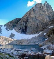
Wind River Range, easy peaks to climb

Does anyone know if Wind River Peak is easily climbed from Black Joe Lake? I did a route this summer circling around Black Joe Lake into that basin just NW of Wind River Peak and it was such a pretty area with NO people around. It would be cool to hit up Wind River Peak from there.
I talked to a couple last summer who descended Wind River Pk via Black Joe Lake - apparently it was pretty miserable. They're both pretty hardcore. Take that for what it's worth.
 
I talked to a couple last summer who descended Wind River Pk via Black Joe Lake - apparently it was pretty miserable. They're both pretty hardcore. Take that for what it's worth.

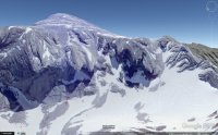
Ya, looks pretty sketchy to me on Google Earth. Your best best is probably that west chute.
Wind River Pk.jpg

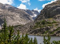
Here's that chute looking from the North shore of Black Joes. Wind River Pk is partially obscured in the clouds of the left.
IMG_5326 - Windrivers08.jpg

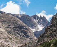
Close up of the chute.
IMG_5326 - Windrivers08-2.jpg

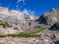
The drainage to the South of Black Joes actually splits. You'd want to go up the east drainage to climb Wind River PK. I've been up the west drainage so I don't have any better photos of the east drainage.

You'd head up here to go into the east drainage. Wind River Pk is in the clouds in the center.
IMG_5341 - Windrivers08.jpg

Some more photos of the area for those interested.

East Temple and Temple Spire.
IMG_5386 - Windrivers08-Pano.jpg

East Temple and the ICE COLD lake below it (yes, I stuck my hand in it).
Windrivers Panorama.jpg

Looking north down the drainage. Black Joes sits in front of the far peaks.
Panorama1.jpg
 
Still planning for this trip. Thanks for all the information.

One question I have is do most bring a bear canister?

I'm planning on a few really short hiking or no trail days but day hikes to peaks. How do you keep your gear during day excursions. I'm thinking of bringing a canister for food. Hanging my sleeping gear and tarp in a tree to keep from rodents. Taking just pack, rain gear, water and food for a day during day trips.
Bears don't really hang out in the higher elevations of the Winds too often. Grizzlies may inhabit the northernmost part of the range. Ursack is your friend.
 
Still planning for this trip. Thanks for all the information.

One question I have is do most bring a bear canister?

I'm planning on a few really short hiking or no trail days but day hikes to peaks. How do you keep your gear during day excursions. I'm thinking of bringing a canister for food. Hanging my sleeping gear and tarp in a tree to keep from rodents. Taking just pack, rain gear, water and food for a day during day trips.

I hang my food and anything that smells (tooth paste, etc.). I leave my tent setup all day long for multiple days and have never had any issue with rodents. I never leave anything that smells in the tent.
 
Ok so I posted this thread almost two years ago.

Well plane tickets booked and car rented. Making a 45 mile loop from Big Sandy trailhead and back.

Just wanted to say thanks to the members that gave advice and post great trip reports that made me want to go.

I’m so excited I have a countdown calendar at work. Going early July.

Plus get to visit an old friend in Saratoga and maybe Douglas.


Sent from my iPhone using Tapatalk Pro
Be sure to come back here and share some of your experience when you get back!
 
I talked to a couple last summer who descended Wind River Pk via Black Joe Lake - apparently it was pretty miserable. They're both pretty hardcore. Take that for what it's worth.
Do you remember their names, Larry?
 
Ok so I posted this thread almost two years ago.

Well plane tickets booked and car rented. Making a 45 mile loop from Big Sandy trailhead and back.

Just wanted to say thanks to the members that gave advice and post great trip reports that made me want to go.

I’m so excited I have a countdown calendar at work. Going early July.

Plus get to visit an old friend in Saratoga and maybe Douglas.


Sent from my iPhone using Tapatalk Pro
You GO boy! NO dust!
 
Here, @Nodust, I offer up this teaser pic taken from the top of Wind River Peak looking norte. Your tic list is in view - offered in trade for telling us what you accomplished once you accomplished it :twothumbs:

If this doesn't stir your mountain-top desires I don't know what will.

View attachment 49583


Wow, it seems so much higher than the Circque, but I think it's about the same altitude as Wolfshead.
 
Wow, it seems so much higher than the Circque, but I think it's about the same altitude as Wolfshead.
Nah, it’s higher. It is the highest south half peak and furthest south 13K’ peak in the Winds.

Wind River Peak - 13,197’
Wolf’s Head - 12,165’
 
Back to the original post. If anyone is looking for information on scrambling peaks in the Winds it would be helpful to get Kelsey’s climbing book. He lists about every peak in the range and all the known routes including lots of class 3.
 
Nah, it’s higher. It is the highest south half peak and furthest south 13K’ peak in the Winds.

Wind River Peak - 13,197’
Wolf’s Head - 12,165’

Wow, I always thought WH was over 13K. I guess Pingora may not even reach 11,000. I'll have to check. My first two summits west of the Mississippi (1987).
 
Back
Top