Wind River – Conditions on Knapsack Col & Knifepoint Glacier?

danibananiiii

New Member
Joined
Mar 20, 2024
Messages
3
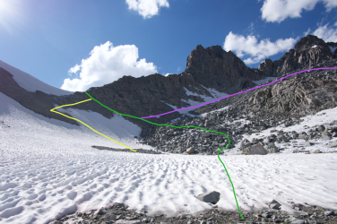
Looking at a route in the Winds in mid-July, near Titcomb Basin. Our route has us going up the west side of Knapsack Col and down the glacier on the east. It also includes heading up to Indian Pass and then down Knifepoint Glacier, before going by Alpine Lakes and eventually Hay Pass.

I'm comfortable off trail, have done my fair share of glissading and summer snow travel, but never anything on an actual glacier. So I guess I want to make sure I'm not getting myself into anything crazy here. I've read some reports from previous years and from what I gather, both are doable in trail runners (and possibly microspikes, depending on conditions).

I am prepared for steep slopes, loose rocks, and lack of traction. I know nothing about crevasses or glacial travel. But I figured I would ask here about these two places, specifically, to make sure I've got my information right. Anyone done Knapsack Col and/or Knifepoint Glacier and can tell me what to expect?
 

From experience of doing that exact route from Indian Pass, Knifepoint can be slow going with your choice of an unstable moraine or crossing a long sheet of glacial ice. I would carry microspikes.
 
Haven't done either but read a lot of reports. No crevasses on either but some sections of Knifepoint are likely to be icy and steep so use of microspikes at least to be safe. Knapsack is the easier of the two. A 2024 report on BPL details a late July crossing of Knapsack Col from Peak L

From Pallister/Wandering Daisy (2023):
"I think late July would be fine but there will be significant snow on the southeast side of Knapsack Col, and the Knifepoint Glacier may still have some current year snow. I have used crampons on the Knifepoint Glacier, and it will allow faster travel, but the main advantage is keeping feet above the water flow. There often is an inch of water running down the glacier. I have never tried it in micro-spikes; it is not steep so they should work but you may get wet feet. That said, I generally do the northern part of the range in mid-August. I have only walked part way up Knapsack Col from the Titcomb side."
 
You can go around the north side on Indian... traverse near the toe of the glacier and eliminated most snow / ice crossing. Below the toe was pretty stable (no real climbing morraines) when i did that. Depends on your comfort level.....

I would not do trail runners in that rocky, scree country..... my opinion.
 
Knapsack Col - 20 July, 2019
West side
DSC00232.jpeg

East side - cornice at top
DSC00251.jpeg


Indian Pass - 14 July, 2014
West side - 8:00am rock hard ice - nasty/deadly runout - traction Required - axe recommended
DSC08004.jpeg

East side - snow softened
DSC08023.jpeg

East side - 16 July, 2016
DSC04685.jpeg

East side - 18 July, 2016
DSC04849.jpeg

East side - 30 July, 2023
DSC02209.jpeg
 
+ early Aug 2022 looking from the base of pass that leads to Alpine Lakes

DSC05154.jpg

p.s. Don't expect to be able to self-arrest on ice, but you could potentially use an ax to downclimb if steep enough.

For a rough comparison of snow pack (less snow = more ice on the permanent snowfield):
Screenshot 2025-06-28 at 1.20.03 PM.png
 
Last edited:
Photo of the glacier in late August of 2013. We did not go up the glacier, but took a somewhat ill advised route up the rocks to the North through the rocks. We made the mistake of going up too close to Bull Lake glacier and found rotten ice under the boulders, which was really unstable and forced us to make some detours, but staying low past that stuff would work just fine, I think. If I were back there again, I'd just bring microspikes and take Knife Point Glacier, but there is the option to do the rocks if it comes to that.

P1080920-L.jpg


The routefinding up the rocks can be a bit tedious, but it does work. This photo is taken from most of the way up, looking back down.
P1080941-L.jpg
 
Anyone have a recent conditions report or photo of the east side of Knapsack Col? I'll be heading to the Winds for my first trip this week and hoping to use that pass as an exit from Titcomb Basin! (Though I seem to be reading a lot of people tend to do this loop in the opposite direction?)
 
Anyone have a recent conditions report or photo of the east side of Knapsack Col? I'll be heading to the Winds for my first trip this week and hoping to use that pass as an exit from Titcomb Basin! (Though I seem to be reading a lot of people tend to do this loop in the opposite direction?)
You'll have no problem. I did it eastbound just last week and it was plenty snow-free. I've got some photos that I'll try and share soon if I can but either way, it's very passable.

To update on my original post: The way up to Knapsack Col from Peak Lake was easy to follow, with just a tad bit of picking your way through scree and talus near the top. No snow. Heading down into Titcomb there appeared to be a trail to looker's right that went over a large snowfield – it seemed plenty passable, but instead we opted to take another faint trail down into a boulder field. We hopped through large boulders (which was entirely doable, but kind of annoying) until we were comfortable crossing just a little bit of snow, and from there it was an easy walk down into the basin. Just the occasional crossing of shallow snow fields. We came down in the afternoon and were able to mostly avoid postholing. Although we had them, our microspikes were not needed.

As for Knifepoint Glacier, we ended up skipping that. I checked satellite views on Caltopo in the days before the trip and it appeared that the section of my original route after Knifepoint (boulder hopping through Alpine Lakes) was too snowy. However now that I compare the current satellite views to what I saw on Knapsack Col, it seems that things look way snowier from above!
 
@zimmertr Here's a photo. I expect you'll have a slightly more difficult time finding the use trail coming from Titcomb, but here's what I did.

Green is the route we took. Close to the top there is a faint use trail which we followed about to where the green line first hits snow. We scrambled just barely above that small bit of snow and then just picked our way through all the boulders until we hit the bigger snow field at the bottom. As you can see, at the bottom the snow is quite thin and there doesn't seem to be much risk of postholing. From that bigger snow field, there's still a ways to go until you round the bend and can see Titcomb Lakes.

Yellow is about where I saw a faint use trail. Assuming the snow doesn't bother you (it looked pretty thin), take your pick of boulder hopping or loose scree.

I've also read about people taking the purple route, staying high over boulders and coming around the north side of a knoll. To me, this looked like it still included a lot of boulder hopping and wasn't as direct so we didn't explore it at all.
 

Attachments

  • annotaed.png
    annotaed.png
    2.8 MB · Views: 5
  • Screenshot 2025-07-21 at 8.09.52 PM.png
    Screenshot 2025-07-21 at 8.09.52 PM.png
    2.8 MB · Views: 5

Don't like ads? Become a BCP Supporting Member and kiss them all goodbye. Click here for more info.

Back
Top