BeardoMcGrath
Member
- Joined
- Jan 31, 2022
- Messages
- 55
Background
I had intended to repay the kindness of folks on this forum by putting together some TRs before now for my trip to SW Utah this past May, but it was a busy summer and so now I finally had some time to follow through!
Normally these trips are day-hike based, since I don’t like dealing with water in the desert and there are a million beautiful campsites one can drive to in Utah. However, the canyons of Fortymile and Willow Gulch had enchanted my friend Joe and I since our first trip to Utah during the Thanksgiving long weekend in 2018. On that trip we arrived at the Sooner Bench TH quite late and only had enough time to hike down to Broken Bow Arch and back, and even then it was dark back at the TH. We resolved to return and explore more of the canyon system on a future trip.
In May 2020 we camped at Sooner Rocks, with the intention of looping from Fortymile to Willow with a car shuttle in-between, as recommended in Kelsey’s Guide. This trip had been delayed due to the pandemic and so it was a very hot hike, but made much better with all the deep wading in Fortymile above its confluence with Willow Gulch. Joe and I wanted to head downcanyon from the confluence, but we cut this hike a little short due to the fact we had left a third friend back at the campsite following a knee injury sustained on a dirtbike the day before. And so we resolved to return again to explore downcanyon.
As May 2023 came around we decided to devote a two night trip into the lower canyon, which was much more explorable thanks to record low water levels on Lake Powell (note: as of this writing the reservoir has come back up to 3570 ft; in order to access the more interesting parts of lower Willow and Bishop Canyons the water level must be below about 3550 ft. At the time of our visit it was about 3535 ft but rising quickly.) Since the previous trip I had gotten a copy of Michael Kelsey’s Lake Powell Guide, which included interesting info on a couple of side canyons in lower Willow Gulch, which at the time of publication still required a boat to access.
Our plan then was to leave a vehicle at Sooner Bench and another at Sooner Rocks; hike down Fortymile Creek to somewhere below the confluence and camp, spend a second day exploring the lower reaches of the canyon and perhaps reach the “270º Alcove” mentioned in Kelsey’s Guide, and then return via Willow Creek to Sooner Bench on the third day. The weather forecast generally looked promising with sunny days and highs in the 70s, though I hoped there wouldn’t be too much deep wading considering the lack of extreme heat.
Joining Joe and I on this trip would be Joe’s friend Brian, who proved to be an excellent companion and a fantastic cook!
Day 1: Sooner Rocks TH to N Fk Confluence
Partly sunny to sunny skies, 70s
After driving most of the way to Escalante from LA the day before and car camping, we made the long drive down the Hole-in-the-Rock Road to the Sooner Bench TH. I did have to stop a few times along the way to admire the flowers; while we didn’t see as much down in the canyon, the trip to Utah overall this year featured some of the best spring color displays I have seen in the desert.


While at the TH organizing our gear, we had the fortune to meet a departing group led by a Glen Canyon park ranger. Given the wet winter I was hoping to get some updated conditions on how much water we’d be dealing with. He had not been through Fortymile yet this year but reported a deep pool just above the Willow/Fortymile confluence in Willow Gulch. On our previous visit there had been two chest deep pools in Fortymile above the confluence, so either way we would bring a tube to ferry packs if necessary. His group would be heading into the lower portion of Willow Gulch as well; however, we never saw any sign of them during our trip.
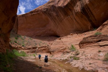
After getting our gear organized, we packed back into my Tacoma and drove back over to Sooner Rocks, hitting the trail at 2 PM. The upper part of the canyon was as I remembered, and we had a little fun dropping through the small slot that circumvents a dryfall in the lower section of Sooner Wash. We reached the confluence of Fortymile at 2:45, and a short time later encountered a pair of hikers coming up the canyon. They reported there was no wading in Fortymile, which surprised us, but they did look pretty dry. They would be the last folks we would see during our stay.
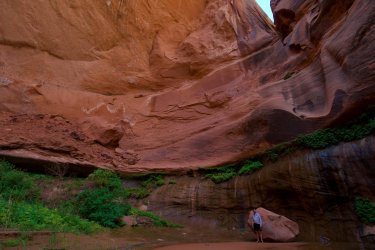
We reached the first big alcove that sports a small granary and rock art around 3:45; this is where Joe and I had been regaling Brian that the canyon got interesting. After high clouds in the morning the sun was now shining and we were enjoying the classic blue-red-green combo that makes the Escalante canyon country famous.

Fun in the slot


Approaching the first big alcove


Old corn cob
Shortly after the ruins the canyon narrows considerably, and the trail cuts around a cool little waterfall and grotto before dropping to the section of trail where wading begins. On our previous trip the waterfall had been a welcome sight in the heat, and we had waded underneath it to cool off. Color us surprised on this trip to find the area below the waterfall completely filled with sand! Usually I would expect a strong monsoon season to scour out these canyons, but instead it appeared everything had been filled in.

Joe and Brian at the filled in waterfall

Same spot in 2020
Below the waterfall we switched to sandals and began our pleasant wade through the narrowest section of Fortymile Creek. This winding section of canyon was very pleasant, with a number of subway type narrows and little springs seeping from the Navajo Sandstone all around. We were amused as at each spot where, while on our previous visit we had needed to ferry packs through a chest deep wade, we found nothing deeper than a shin deep sections of water. The canyons truly do change on every visit! Aside from an old cottonwood log wedged in such a way we had to crawl in the water to get under, passage was easy all the way to the confluence of Willow and Fortymile.

The one obstacle

Joe at the filled in pool

Same spot in 2020


Unlucky wildlife
Arriving at the Willow/Fortymile confluence around 5:30, we dropped our packs to take the short walk to the other water obstacle up Willow Gulch. Unlike the deeper spots along Fortymile that had been filled in, the pool here was bigger than the last time and pretty deep looking, with some pretty significant mud as well. Luckily it was a problem for another day!
Heading downcanyon into new territory was fun, although we did have to contend with intermittent brush in this section. The ranger we saw earlier in the day recommended campsites along this portion of the canyon, but everywhere we looked we just saw thick brush or steep slopes climbing out of the creek bottom. We went all the way to the waterfall obstacle (which we bypassed to the right after some searching around for a trail) before we found anything suitable for the night. In the end we were able to climb up a sandy slope (likely deposited 20 years ago when the reservoir was near full pool) to an open area just above the confluence of the N Fk. This spot afforded views up and down the canyon, and also got us a little closer to Bishop Canyon which we hoped to explore tomorrow.

Brian below the confluence of Willow/Fortymile

Looking for a way past the waterfall; note we are below the HWM

Below the waterfall
Arriving just after 6:30, we set up camp and watched the shadows climb the canyon walls around us. All clouds had cleared by this point and so we got to enjoy watching the stars come out before retiring for the night.

Camp


Downcanyon from above camp
Day 2: N Fk Confluence to the big alcove in Bishop Canyon and back
Sunny to Mostly Sunny, 70s
I was up fairly early the next morning, in order to catch the sunrise and otherwise enjoy the quiet of a canyon morning while Brian and Joe got a little more sleep. From behind our tents it was possible to scramble up to a slickrock shelf, and get a view straight down the canyon. This shelf apparently used to sit right near the high water mark, because after some exploration I found an old fire ring and grooves in the sandstone likely caused by landed houseboats.

Joe and morning sun

Old fire ring at the HWM
Once everyone was up and the sun began shining down to our little campsite, it quickly began warming up and I had no worries that we would have a very enjoyable day temps-wise. We had a fairly lazy start, around 9:15, and were able to immediately hike barefoot along the sandy bottom of the creek. We had considered checking out the N Fk but it was pretty brushy near the mouth and given the distance to the head of Bishop we decided to defer that. A good section of the canyon was very pleasant walking, with mostly ankle deep water. Eventually we reached the first and only real obstacle of the day, a beaver pond. The water and mud were deep enough we had to brush bash for a short section around the dam, but below that it was back to easy walking.

The author just below camp

First little cascade

Navigating the beaver pond

Below the dam
While there had been some brush to contend with above the beaver dam, below it the way was mostly more rocky and open, with occasional little cascades over the slickrock. I was highly motivated to stay barefoot, both for the enjoyment and also the fact that wearing sandals was quickly leading to blisters, something I don’t usually get. This was generally easy, except for where it was rocky or where there were some small spiny plants hidden in the sand!
As we neared the jct with Bishop Canyon the amount of vegetation really diminished, as this part of the canyon had only been uncovered for a couple years (and has now been reflooded). While this section of Willow Gulch is wider than the upper sections, there are still towering walls and the long straight section before Bishop Canyon was quite impressive. Once this blip in the shrinkage of the reservoir is over in a few years, this will be a great place to revisit.

Green tunnel

Reaching the next little cascade

High walls just before Bishop Canyon. The mouth of Bishop is the obvious notch in the wall in the sun photo-right
We reached the jct with Bishop Canyon a little after 11 AM. We considered continuing down Willow to see the lake but decided to devote our time to Bishop instead. We were finally forced to don sandals going up the lower section of Bishop, as for the first time we encountered deep mud/quicksand along the water course. Fortunately this section was quite short and we were soon enjoying the high walls of lower Bishop. After a snack in the shade of one of the massive overhangs in the lower canyon, we continued along, sometimes in light brush but mostly along the sandy bottom of the canyon. Arguably the most impressive section of this canyon is below the high water mark, and so not mentioned in Kelsey’s Guide at all. The walls are very very high and there are some impressive alcoves.
A little farther up the canyon we left the sandy bottom and got onto slickrock, which made for a bit easier walking though quite slippery in places. At one point we reached this really nice pool/grotto, where we were able to fill up on water and also go for a refreshing swim, since part of the pool was more than 10 feet deep! The only downside was the lack of sun when we got out, but farther up the canyon we were back in the sun and dried out quickly.

Lower Bishop. This section only had some grasses; there was more brush farther along. Note the dead shellfish on the canyon walls


Deep alcove

Past the brush and onto slickrock

Nearing the swimming pool

Filling water at the pool, behind Joe and Brian it was ~10 ft deep!

Climbing slickrock just above the pool
By this point the afternoon was getting on and we still had not reached the 270º alcove. As most folks know, canyon country hiking can take a long time, especially snaking through the bottom of one. Eventually we reached a spot where the small stream narrowed into a slot, which we were easily able to shimmy over. Above this point we were definitely above the high water mark, so there was more brush and we had to climb up and out of the bottom over a sand hill to reach the last section of hikable canyon. Fighting past the numerous and extensive patches of poison ivy, we finally rounded a bend and approached what had to be the final alcove and dryfall. Kelsey’s description of this spot is apt, and despite my wide angle lens it was quite difficult to capture the scene.

My favorite pic in Bishop


Shimmying over the small slot

Brian climbing over the small sand hill. It was hot back out in the sun!

Approaching the alcove and dryfall


Late lunch in the alcove. Even 11mm isn't wide enough!


Joe and the dryfall
After a rather late lunch and a half hour stay in another magical spot in Escalante country, it was after 3 PM and we had already pushed past our supposed turn around time. It would be a rather slow return walk to camp, so we set out, enjoying the brand new views afforded us by heading back down the canyon. The walk back down Bishop was mostly uneventful, though we did stumble upon some old boater garbage and took time to investigate the huge swaths of dead invasive mussels on some of the walls below the high water mark.

Lots of wading


Cowboys fans truly are everywhere. We wanted to pack this out but it was too gross/heavy

High and dry

Dead cottonwood near the confluence of Bishop and Willow

These flowers would be flooded two weeks later
Back at the confluence with Willow Gulch we had a snack in the shade, ahead of our hike back up the canyon. Since it was later in the day we appreciated the shade from the canyon walls, and we actually made pretty good time back through the brush and beaver pond to camp, arriving at 7:30–before dark! Overall an excellent day to an infrequently visited portion of the Willow Creek drainage.
Day 3: N Fk Confluence to Sooner Bench TH
Sunny to partly cloudy, 70s
It was warmer overnight and we enjoyed another sunny morning at camp, disembarking around 9:20. Some members of our party were a little worse for wear: we all had some sensitive spots on our feet from wading in sandals, and both Joe and Brian had some lower leg issues from all the other walking barefoot–in Brian’s case a small step of rock had collapsed under him the day before and strained his achilles. However spirits were still pretty high as we returned up the canyon to the Fortymile/Willow confluence. Walking this section was a bit more difficult than we remembered, both due to fatigue and the fact that one must fight the brush more vigorously heading upstream than down.
Before long we reached the Fortymile confluence and our most exciting obstacle: the deep wade in Willow just above. On our previous visit in 2020 this had been a somewhat deep pool but pretty easy; this time the water was much deeper and the mud as well. We sent Joe ahead to scout it out; he reported up to neck deep and shin deep mud as well, but no swimming required. So I pulled out my Wal-Mart inner tube and we began the process of ferrying packs and bodies through the water. While it was a bit chilly in the shade, the step up at the end was into the sun and much appreciated. All in all not a very difficult obstacle and a fun way to rinse the desert grime off!

Joe tests the waters


View from the upper end
Once on the other side we spent some time enjoying the warm sun before finally donning our hiking boots again for the final hike up the canyon. Kelsey describes this section as the nicest along Willow Gulch, and indeed it is with high walls and alcoves rising above a slickrock bottom. Beyond that we were back on a trail more or less, although there are still some brushy areas to contend with where the stream is too deep to walk through.

More slickrock walking in Willow Gulch
We reached the familiar sight of Broken Bow Arch at Noon, and were surprised to see no one around considering it was Friday. We topped off on a little water here, before beginning the climb up and out of the canyon to reach Sooner Bench. Fortunately some clouds had begun to move in and provided some shade for the ascent, though the many wildflowers in this section provided ample additional distraction. Before we knew it we could see the mortarboard rock and final sand climb to Joe’s Tacoma at the TH; it had only taken an hour from the arch to reach the vehicle and some cool refreshments.

Flowers at Broken Bow Arch

Color on our climb out
Conclusions
This was a great short backpack to an area Joe and I have enjoyed visiting on multiple occasions. We ended up having great weather, as the remainder of our trip to Utah was filled with cloudier skies and somewhat unstable conditions. An extra day in the canyon would be even better, and provide time to explore down to the Escalante River itself when the Lake Powell water level is lower. And while Brian’s gravity filter took it pretty hard, water was never a problem hiking through the wet canyon bottoms. Following this trip we drove up to Fiftymile Bench in order to hike around Fiftymile Mtn.
I had intended to repay the kindness of folks on this forum by putting together some TRs before now for my trip to SW Utah this past May, but it was a busy summer and so now I finally had some time to follow through!
Normally these trips are day-hike based, since I don’t like dealing with water in the desert and there are a million beautiful campsites one can drive to in Utah. However, the canyons of Fortymile and Willow Gulch had enchanted my friend Joe and I since our first trip to Utah during the Thanksgiving long weekend in 2018. On that trip we arrived at the Sooner Bench TH quite late and only had enough time to hike down to Broken Bow Arch and back, and even then it was dark back at the TH. We resolved to return and explore more of the canyon system on a future trip.
In May 2020 we camped at Sooner Rocks, with the intention of looping from Fortymile to Willow with a car shuttle in-between, as recommended in Kelsey’s Guide. This trip had been delayed due to the pandemic and so it was a very hot hike, but made much better with all the deep wading in Fortymile above its confluence with Willow Gulch. Joe and I wanted to head downcanyon from the confluence, but we cut this hike a little short due to the fact we had left a third friend back at the campsite following a knee injury sustained on a dirtbike the day before. And so we resolved to return again to explore downcanyon.
As May 2023 came around we decided to devote a two night trip into the lower canyon, which was much more explorable thanks to record low water levels on Lake Powell (note: as of this writing the reservoir has come back up to 3570 ft; in order to access the more interesting parts of lower Willow and Bishop Canyons the water level must be below about 3550 ft. At the time of our visit it was about 3535 ft but rising quickly.) Since the previous trip I had gotten a copy of Michael Kelsey’s Lake Powell Guide, which included interesting info on a couple of side canyons in lower Willow Gulch, which at the time of publication still required a boat to access.
Our plan then was to leave a vehicle at Sooner Bench and another at Sooner Rocks; hike down Fortymile Creek to somewhere below the confluence and camp, spend a second day exploring the lower reaches of the canyon and perhaps reach the “270º Alcove” mentioned in Kelsey’s Guide, and then return via Willow Creek to Sooner Bench on the third day. The weather forecast generally looked promising with sunny days and highs in the 70s, though I hoped there wouldn’t be too much deep wading considering the lack of extreme heat.
Joining Joe and I on this trip would be Joe’s friend Brian, who proved to be an excellent companion and a fantastic cook!
Day 1: Sooner Rocks TH to N Fk Confluence
Partly sunny to sunny skies, 70s
After driving most of the way to Escalante from LA the day before and car camping, we made the long drive down the Hole-in-the-Rock Road to the Sooner Bench TH. I did have to stop a few times along the way to admire the flowers; while we didn’t see as much down in the canyon, the trip to Utah overall this year featured some of the best spring color displays I have seen in the desert.
While at the TH organizing our gear, we had the fortune to meet a departing group led by a Glen Canyon park ranger. Given the wet winter I was hoping to get some updated conditions on how much water we’d be dealing with. He had not been through Fortymile yet this year but reported a deep pool just above the Willow/Fortymile confluence in Willow Gulch. On our previous visit there had been two chest deep pools in Fortymile above the confluence, so either way we would bring a tube to ferry packs if necessary. His group would be heading into the lower portion of Willow Gulch as well; however, we never saw any sign of them during our trip.
After getting our gear organized, we packed back into my Tacoma and drove back over to Sooner Rocks, hitting the trail at 2 PM. The upper part of the canyon was as I remembered, and we had a little fun dropping through the small slot that circumvents a dryfall in the lower section of Sooner Wash. We reached the confluence of Fortymile at 2:45, and a short time later encountered a pair of hikers coming up the canyon. They reported there was no wading in Fortymile, which surprised us, but they did look pretty dry. They would be the last folks we would see during our stay.
We reached the first big alcove that sports a small granary and rock art around 3:45; this is where Joe and I had been regaling Brian that the canyon got interesting. After high clouds in the morning the sun was now shining and we were enjoying the classic blue-red-green combo that makes the Escalante canyon country famous.
Fun in the slot
Approaching the first big alcove
Old corn cob
Shortly after the ruins the canyon narrows considerably, and the trail cuts around a cool little waterfall and grotto before dropping to the section of trail where wading begins. On our previous trip the waterfall had been a welcome sight in the heat, and we had waded underneath it to cool off. Color us surprised on this trip to find the area below the waterfall completely filled with sand! Usually I would expect a strong monsoon season to scour out these canyons, but instead it appeared everything had been filled in.
Joe and Brian at the filled in waterfall
Same spot in 2020
Below the waterfall we switched to sandals and began our pleasant wade through the narrowest section of Fortymile Creek. This winding section of canyon was very pleasant, with a number of subway type narrows and little springs seeping from the Navajo Sandstone all around. We were amused as at each spot where, while on our previous visit we had needed to ferry packs through a chest deep wade, we found nothing deeper than a shin deep sections of water. The canyons truly do change on every visit! Aside from an old cottonwood log wedged in such a way we had to crawl in the water to get under, passage was easy all the way to the confluence of Willow and Fortymile.
The one obstacle
Joe at the filled in pool
Same spot in 2020
Unlucky wildlife
Arriving at the Willow/Fortymile confluence around 5:30, we dropped our packs to take the short walk to the other water obstacle up Willow Gulch. Unlike the deeper spots along Fortymile that had been filled in, the pool here was bigger than the last time and pretty deep looking, with some pretty significant mud as well. Luckily it was a problem for another day!
Heading downcanyon into new territory was fun, although we did have to contend with intermittent brush in this section. The ranger we saw earlier in the day recommended campsites along this portion of the canyon, but everywhere we looked we just saw thick brush or steep slopes climbing out of the creek bottom. We went all the way to the waterfall obstacle (which we bypassed to the right after some searching around for a trail) before we found anything suitable for the night. In the end we were able to climb up a sandy slope (likely deposited 20 years ago when the reservoir was near full pool) to an open area just above the confluence of the N Fk. This spot afforded views up and down the canyon, and also got us a little closer to Bishop Canyon which we hoped to explore tomorrow.
Brian below the confluence of Willow/Fortymile
Looking for a way past the waterfall; note we are below the HWM
Below the waterfall
Arriving just after 6:30, we set up camp and watched the shadows climb the canyon walls around us. All clouds had cleared by this point and so we got to enjoy watching the stars come out before retiring for the night.
Camp
Downcanyon from above camp
Day 2: N Fk Confluence to the big alcove in Bishop Canyon and back
Sunny to Mostly Sunny, 70s
I was up fairly early the next morning, in order to catch the sunrise and otherwise enjoy the quiet of a canyon morning while Brian and Joe got a little more sleep. From behind our tents it was possible to scramble up to a slickrock shelf, and get a view straight down the canyon. This shelf apparently used to sit right near the high water mark, because after some exploration I found an old fire ring and grooves in the sandstone likely caused by landed houseboats.
Joe and morning sun
Old fire ring at the HWM
Once everyone was up and the sun began shining down to our little campsite, it quickly began warming up and I had no worries that we would have a very enjoyable day temps-wise. We had a fairly lazy start, around 9:15, and were able to immediately hike barefoot along the sandy bottom of the creek. We had considered checking out the N Fk but it was pretty brushy near the mouth and given the distance to the head of Bishop we decided to defer that. A good section of the canyon was very pleasant walking, with mostly ankle deep water. Eventually we reached the first and only real obstacle of the day, a beaver pond. The water and mud were deep enough we had to brush bash for a short section around the dam, but below that it was back to easy walking.
The author just below camp
First little cascade
Navigating the beaver pond
Below the dam
While there had been some brush to contend with above the beaver dam, below it the way was mostly more rocky and open, with occasional little cascades over the slickrock. I was highly motivated to stay barefoot, both for the enjoyment and also the fact that wearing sandals was quickly leading to blisters, something I don’t usually get. This was generally easy, except for where it was rocky or where there were some small spiny plants hidden in the sand!
As we neared the jct with Bishop Canyon the amount of vegetation really diminished, as this part of the canyon had only been uncovered for a couple years (and has now been reflooded). While this section of Willow Gulch is wider than the upper sections, there are still towering walls and the long straight section before Bishop Canyon was quite impressive. Once this blip in the shrinkage of the reservoir is over in a few years, this will be a great place to revisit.
Green tunnel
Reaching the next little cascade
High walls just before Bishop Canyon. The mouth of Bishop is the obvious notch in the wall in the sun photo-right
We reached the jct with Bishop Canyon a little after 11 AM. We considered continuing down Willow to see the lake but decided to devote our time to Bishop instead. We were finally forced to don sandals going up the lower section of Bishop, as for the first time we encountered deep mud/quicksand along the water course. Fortunately this section was quite short and we were soon enjoying the high walls of lower Bishop. After a snack in the shade of one of the massive overhangs in the lower canyon, we continued along, sometimes in light brush but mostly along the sandy bottom of the canyon. Arguably the most impressive section of this canyon is below the high water mark, and so not mentioned in Kelsey’s Guide at all. The walls are very very high and there are some impressive alcoves.
A little farther up the canyon we left the sandy bottom and got onto slickrock, which made for a bit easier walking though quite slippery in places. At one point we reached this really nice pool/grotto, where we were able to fill up on water and also go for a refreshing swim, since part of the pool was more than 10 feet deep! The only downside was the lack of sun when we got out, but farther up the canyon we were back in the sun and dried out quickly.
Lower Bishop. This section only had some grasses; there was more brush farther along. Note the dead shellfish on the canyon walls
Deep alcove
Past the brush and onto slickrock
Nearing the swimming pool
Filling water at the pool, behind Joe and Brian it was ~10 ft deep!
Climbing slickrock just above the pool
By this point the afternoon was getting on and we still had not reached the 270º alcove. As most folks know, canyon country hiking can take a long time, especially snaking through the bottom of one. Eventually we reached a spot where the small stream narrowed into a slot, which we were easily able to shimmy over. Above this point we were definitely above the high water mark, so there was more brush and we had to climb up and out of the bottom over a sand hill to reach the last section of hikable canyon. Fighting past the numerous and extensive patches of poison ivy, we finally rounded a bend and approached what had to be the final alcove and dryfall. Kelsey’s description of this spot is apt, and despite my wide angle lens it was quite difficult to capture the scene.
My favorite pic in Bishop
Shimmying over the small slot
Brian climbing over the small sand hill. It was hot back out in the sun!
Approaching the alcove and dryfall
Late lunch in the alcove. Even 11mm isn't wide enough!
Joe and the dryfall
After a rather late lunch and a half hour stay in another magical spot in Escalante country, it was after 3 PM and we had already pushed past our supposed turn around time. It would be a rather slow return walk to camp, so we set out, enjoying the brand new views afforded us by heading back down the canyon. The walk back down Bishop was mostly uneventful, though we did stumble upon some old boater garbage and took time to investigate the huge swaths of dead invasive mussels on some of the walls below the high water mark.
Lots of wading
Cowboys fans truly are everywhere. We wanted to pack this out but it was too gross/heavy
High and dry
Dead cottonwood near the confluence of Bishop and Willow
These flowers would be flooded two weeks later
Back at the confluence with Willow Gulch we had a snack in the shade, ahead of our hike back up the canyon. Since it was later in the day we appreciated the shade from the canyon walls, and we actually made pretty good time back through the brush and beaver pond to camp, arriving at 7:30–before dark! Overall an excellent day to an infrequently visited portion of the Willow Creek drainage.
Day 3: N Fk Confluence to Sooner Bench TH
Sunny to partly cloudy, 70s
It was warmer overnight and we enjoyed another sunny morning at camp, disembarking around 9:20. Some members of our party were a little worse for wear: we all had some sensitive spots on our feet from wading in sandals, and both Joe and Brian had some lower leg issues from all the other walking barefoot–in Brian’s case a small step of rock had collapsed under him the day before and strained his achilles. However spirits were still pretty high as we returned up the canyon to the Fortymile/Willow confluence. Walking this section was a bit more difficult than we remembered, both due to fatigue and the fact that one must fight the brush more vigorously heading upstream than down.
Before long we reached the Fortymile confluence and our most exciting obstacle: the deep wade in Willow just above. On our previous visit in 2020 this had been a somewhat deep pool but pretty easy; this time the water was much deeper and the mud as well. We sent Joe ahead to scout it out; he reported up to neck deep and shin deep mud as well, but no swimming required. So I pulled out my Wal-Mart inner tube and we began the process of ferrying packs and bodies through the water. While it was a bit chilly in the shade, the step up at the end was into the sun and much appreciated. All in all not a very difficult obstacle and a fun way to rinse the desert grime off!
Joe tests the waters
View from the upper end
Once on the other side we spent some time enjoying the warm sun before finally donning our hiking boots again for the final hike up the canyon. Kelsey describes this section as the nicest along Willow Gulch, and indeed it is with high walls and alcoves rising above a slickrock bottom. Beyond that we were back on a trail more or less, although there are still some brushy areas to contend with where the stream is too deep to walk through.
More slickrock walking in Willow Gulch
We reached the familiar sight of Broken Bow Arch at Noon, and were surprised to see no one around considering it was Friday. We topped off on a little water here, before beginning the climb up and out of the canyon to reach Sooner Bench. Fortunately some clouds had begun to move in and provided some shade for the ascent, though the many wildflowers in this section provided ample additional distraction. Before we knew it we could see the mortarboard rock and final sand climb to Joe’s Tacoma at the TH; it had only taken an hour from the arch to reach the vehicle and some cool refreshments.
Flowers at Broken Bow Arch
Color on our climb out
Conclusions
This was a great short backpack to an area Joe and I have enjoyed visiting on multiple occasions. We ended up having great weather, as the remainder of our trip to Utah was filled with cloudier skies and somewhat unstable conditions. An extra day in the canyon would be even better, and provide time to explore down to the Escalante River itself when the Lake Powell water level is lower. And while Brian’s gravity filter took it pretty hard, water was never a problem hiking through the wet canyon bottoms. Following this trip we drove up to Fiftymile Bench in order to hike around Fiftymile Mtn.
Attachments
Last edited: