What’s your unfinished business? Hard canyon access, mtn peak, you name it!

My nemesis was Mt. Sneffels. Nothing technical about it, just grind your way up, big scree field. First time was in high school when my brother and I "borrowed" my dad's pickup and tried to drive up the Yankee Boy Basin side. My dad was out of town and forbade us from ever driving his collectible truck (he knew). We almost got to the trailhead when I ran over a rock and destroyed the oil pan and a few other critical parts, like the manifold. We limped it home and had the shop repair things. I told them to put in used parts, as my dad was a good mechanic and would've noticed a new part. I told him years later and he didn't believe me.

Second try, my nephew, brother, and I tried it from the Blue Lakes side, backpacking. We got to the upper lake and were stymied by a blizzard and lightning and ended up retreating. (We didn't check the weather.)

Third time, Yankee Boy side, my brother and I finally claimed success until we actually looked over and saw we weren't on the summit but had instead gone up a sub peak. We hadn't been able to see where we were until we got on top. (We didn't have a topo.) It was fairly technical and I think it might've been Kismet.

Fourth time, success, finally. I've climbed it twice since then just to gloat over being up there after all those failures.

View attachment 116436
Really nice pic.......... never could understand the urge to climb to the top of a mountain just to climb it. Just something I dont do, but I respect those who do, lots of energy expended, drive and stamia.
 
What a great question. My 2 are relatively easy areas to access but stuff happens.

The first was Pitchstone Plateau in YNP. The first planned trip ended when my hiking partner admitted defeat from altitude effects. He lives near sea level and it didn't take long for 7500 feet elevation to crush his ability to continue, especially as he contemplated gaining another 1500 feet that day. The second attempt was blocked by a snow storm. I could have continued up but figured with the winds howling up high that it was not worth leaving the sheltering forest for the exposed plateau top so hiked out. I have since been up there twice.

The other is Mirror Plateau in YNP. The first time I was with my wife and kids and after camping at Moss Creek the kids decided they didn't want to spend 2 more nights out so we backtracked out. They were 10 and 11 at the time. The second time I was going to hike up from Lamar R/Cache Creek area but after almost 12 hours of heavy rains the previous afternoon, evening and night, the Lamar R was un-crossable. The 3rd time I had a trip planned that would take us up Sour Creek to Fern L CS, then to Upper Pelican Cr CS and Upper Opal Cr CS but the deadfall along upper Sour Creek (it was horrible) killed my wife's desire to continue as planned. So we looped around to the north and out. Then last year I had an off-trail route planned, and still do, but I could not obtain a permit for the restricted campsites on top. I have an aternate plan that will let me traverse much of Mirror Plateau without needing to stay at the restricted campsites so hopefully next year.

Sour Creek is a tough hall. Did you find that you kept looking at the other side of the creek and thinking, "It looks like easier going over there." And of course, once you crossed over, you were soon thinking the exact same thing of the side you just crossed over from? :) We ended up leaving the creek and working our way up the southern hillside, though I'm not sure that ended up being any easier. The stream to the east of Bluff Creek had the best water I think I have ever tasted.
 
Making it to Bog Creek was pretty easy overall except for that last meadow on the south side just before Bog Creek, which was tussocky. Upstream of Bog Creek, where the burned area starts is when it all went to scat. Once we entered the burned area, the other side did always look better but for the most part we stayed on the north hillside until the Bluff Creek confluence. Had I not been so tunnel-visioned, we would have cut south where Bluff Creek comes into Sour Creek and followed Bluff Creek a ways but...

My next planned route in there will start at Fishing Bridge, following the trail to just beyond LeHardy Rapids, then go off-trail to upper Bluff Creek, where I'll camp. I'll then continue off-trail to the Ponunipa Springs area. Then a short haul to Fern L and beyond. I know my wife will decline that invitation.
I had a route very similar except starting through Wrangler lk to Fern then Bluff to Le Hardy back across by the river trail. Had a fire north of fishing bridge that year and they canceled us..... haven t done it.
 
I have a lot of unfinished business because I was running out of time before the winter closures.
The stupid wildfires and the horrible air quality here prevented me from doing the last of my hikes before moving home to Hawaiʻi.
After I move, Iʻm probably not coming back to the mainland anytime soon
 
Actually participating in an epic @scatman and @TractorDoc adventure in Yellowstone. Hopefully I will be in better shape (mentally and physically) than I was this past September.
I think Scat / me will have one coming up... If I can convince him ....
 
Never failed, but I've ditched a route without trying.
To my shame, I let other people dissuade me from a known offtrail route in the Weminuche last year.
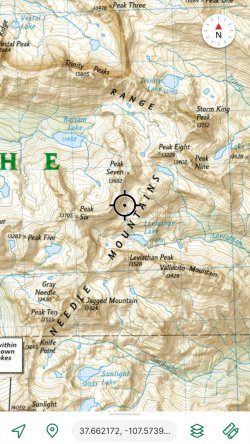
This will only mean something to people familiar with the area, but I had planned to go up through Vestal Basin(top left) over to Trinity Lake, around Storm King, by Silex and Leviathan Lakes, ending at Sunlight(bottom).
Screenshot_20221110_222046_Avenza Maps.jpg

I met 3 young guys who had bailed at the head of Vestal Basin, saying it was way too sketchy. Looking at it in person, I thought it looked pretty sketchy, too, from where I was standing, and hiked back out the way I'd come.

Then, a couple days later I decided to go up to Sunlight from the Vallecito, and met another pair of young guys who told me the route was practically impassable due to deadfalls, so didn't do that, either.

Later, I found a pic of the same place in Vestal from a different vantage point, and realized it was not nearly as bad as I thought. Also realized that well-meant warnings like the second one usually mean little to me, because my comfort zone is quite a bit broader than most.

I've been kicking myself for not following my planned route ever since. Now I'm planning trips further north, and don't know when or if I'll ever make it back there...
 
That’s our unfinished business - the train and the Weminuche! We were so excited for that adventure back in 2018, but unfortunately fires prevented us from doing it. (And we saw that perhaps a cinder from the train had started the fire.) We had a great time in the Holy Cross Wilderness instead (which was a BCP recommendation we really appreciated), but we still hope to someday get off that train at its middle-of-nowhere stop!
 
I chuckled. I always feel a little rude when someone kindly gives me such a warning and then watches me completely ignore it.
I wish my comfort zone were broader! But I think comfort zone is closely tied to physical ability and experience, and I don’t have a ton of either. Before going down Death Hollow on the Boulder Mail Trail, I knew it would be a stretch for us, and it certainly was. But I had read some people’s descriptions that barely even mentioned the exposure. So I have definitely known there is a huge range in comfort zone and wouldn’t give someone advice, just a description - so they can decide for themselves. How nice for those of you who can do sketchy things and thrive!
 
Lol .... I never do any sketchy ........ Well can't think of any I would call sketchy ..... But people with me ? I get comments at times ..... If I get info from people, with research I have always stuck with my plan .... Usually keep two options for routes as I go along
 
I chuckled. I always feel a little rude when someone kindly gives me such a warning and then watches me completely ignore it.
I know that feeling.... I just shake my head, day thanks and go on..... I value my research more and my actually looking at it on the ground to decide.

If I give info out, I try as just a description. Also try to feel out what others experience is for a determination
 
I have a lot of unfinished business because I was running out of time before the winter closures.
The stupid wildfires and the horrible air quality here prevented me from doing the last of my hikes before moving home to Hawaiʻi.
After I move, Iʻm probably not coming back to the mainland anytime soon
Wait… you just moved I thought from Utah to the NW, so when are you moving back to Hawaii?
 
My unfinished business is the route from Bremner mining camp to Tebay Lake in Wrangell-St Elias. Joey and I had intended to do that portion but we ended up stopping early, mostly on my choice. I think it was a fair decision at the time, but it still bothers me that I didn't finish the trip. Someday I'd like to go back and do the full route from Iceberg Lake to Tebay Lake. But there are also other parts of Alaska I'd like to see, so it depends on what opportunity presents itself.

Speaking of which, anybody want to hike in Alaska next year? I need to make some real backpacking plans, the last time I did any backpacking was in fact my last time up there in Alaska.
 
I chuckled. I always feel a little rude when someone kindly gives me such a warning and then watches me completely ignore it.
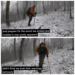
Ok, that cracked me up. My friend and I were on our way to camp on a bald during a winter storm in the NC mountains to test our shelters. That was our excuse to get out in it, anyway.
Had to pull up his video from that hike. A group of young guys(recurring theme?) warned us about continuing, and how bad conditions were getting higher up.

2022-11-11 19-26-49.png
 
That’s our unfinished business - the train and the Weminuche! We were so excited for that adventure back in 2018, but unfortunately fires prevented us from doing it.
Love that area. Made mid to late September trips in 2014, 2018, and 2021. Except for hitting teens up high on one night(Vestal Basin, not on any trails), low temps have been 29-45F and it's mostly been pleasnt in the daytime.
In spite of that, there aren't many backpackers that late in the season. There's usually at least one day that I don't see anyone at all, and I've only had to camp near other people once.
 
Back
Top