Arizona Jones
Member
- Joined
- Aug 1, 2020
- Messages
- 70
I first heard of Wet Beaver Creek through Kelsey's book Canyon Hiking Guide To The Colorado Plateau. I bought the book back in the mid 1980s when I was going to visit Utah. At that time my parents had retired to Cottonwood AZ, when I visited them I started exploring Wet Beaver Creek and West Clear Creek. Then circumstances brought me to live in Cottonwood to care for my parents and these canyons have been my go to places now for well over 20 years. I found it to be surprising that both West Clear Creek and Wet Beaver Creek made Kelsey's list for top 22 favorite hikes in the back of the book. I consider Wet Beaver Creek, West Clear Creek's little brother and my old friend.  Wet Beaver Creek runs from east to west and just like West Clear Creek it has many deep pools that you must swim to travel up or down the canyon. And just like West Clear Creek there is no trail in the middle part of the canyon and the going can be very difficult. But just like West Clear Creek the payoff is a remote wilderness experience of extreme beauty and solitude.
The total distance to do a through hike of this canyon from Waldroup Place up on the rim to the trail head parking lot at the mouth of the canyon is 15 miles. This would require a car shuttle. Many people start at the trail head parking lot and then do a loop hike by taking the Apache Maid Trail up to the rim and then drop down into the canyon at Waldroup Place and then travel down the canyon and back to the Bell Trail parking area.
The majority of the people that visit Wet Beaver Creek are day hikers that come up the Bell Trail and stop at a swimming hole known as The Crack. The Crack has two deep pool conected by a short slot or channel and has this unique red rock diving board.
  The Crack is about four miles from the parking area on a maintained trail. The first two miles is a wide double track or jeep trail, and the rest is a foot trail along a ledge or bench above the creek until you get to The Crack. The trail is called the Bell Trail and it was used in the old days to move cattle from the lower areas up to the rim for the summer.
To do the loop trip you will take the Apache Maid Trail up and around. After about two miles you will come to a trail on the left called Apache Mail trail #15. This trail climbs steeply up to the north rim of the canyon gaining at least 1200 feet of elevation and then gets very vague as it travels on intermittent jeep tracks east to the access point called Waldroup place at the east or upper end of the canyon. This is a long trek with no water sources, that will gain and loose altitude as you go and if you are going to go down the canyon it means you will be doing this in the hot summer months. It is about 9 and 1/4 miles from the trail head to Waldrop Place. It is about 2 miles from Waldroup Place to get down into the main canyon. Then about 9 miles down the canyon till you pick up the Bell trail near the crack and about 4 more miles back down the Bell trail to the car for a total of around 24 miles for the loop. I once drove around to Waldroup place and just started from up there and just returned back the same way. This is a rugged access with seven dry falls you have to find a way around. When you get into the canyon it is dry at first but as you head west or downstream you will soon find several springs that are the source of Wet beaver Creek and then right away there will be a few big pools you must swim to go any farther down the canyon. The travel in the 9 mile trailess part of the canyon is very tough and strenuous with travel average at 3/4 miles per hour. To do the loop you could do it in two days but most would take three to make it enjoyable.
Anyway most people just come up from the Bell Trail to The Crack for a day hike and swim . There are also taller cliffs on one side that brave or crazy people sometimes jump off into the water. The Crack can be very crowded on hot summer days, but this is where most of the people stop. But if you keep going up the canyon you will find it to be beautiful, wild, and best of all there will be few people. Now the walk up the Bell Trail is a dry and hot four miles with very little shade. And much of it is up away from the creek with the sound of the water below teasing you as you go. In one spot along the Bell Trail there is a large basalt boulder with what appears to be Anasazi Petroglyphs. This is not unusual here, and I have fould many sites with rock art in the surrounding area. This beginning part of the canyon is wide open but then starts to close in after a few miles.
  At about 2.7 miles there is a trail to the right that goes down to the creek called the Weir Trail, this is tempting but will not get you to The Crack and the best stuff. Keep on the upper trail and it will take you up on a bench high above the creek.
  And at about the 4 mile mark you will see a trail (The Bell Trail) heading down to the right toward the creek and one going straight. Take the straight one that will take you upstream to The Crack. The bell Trail will take you to Bell Crossing and cross the creek and then will climb the steep canyon walls to the rim above.
 Once at The Crack to head up stream you will just be boulder hopping, wading, fighting through willow thickets and brush, and swimming.
  You will be able to see some paths that others have taken that are the "least resistance" and that will help but this is primitive route finding. You will be doing extensive boulder hopping along the banks or in the creek.
  The creek is lined with willows that you will need to fight your way through as you cross from one side of the creek to the other. The creek bottom itself is very slippery with algae covered rock and it is best to avoid walking in the creek bottom as it will severely slow you down. After at around an hour from The Crack you will encounter the first big pool or obstacle.
 You must swim through this long pool to go any farther. And soon this will become the mode of travel so get used to it. In fact that is the fun part of this trip to swim in the cool deep shady pools while the rest of Arizona is baking in the hundred plus heat.
  Another half hour or more upstream you will encounter more deep pools you must swim and soon there is a series of pools one after another that you will have to swim to go any farther.
  In this section of the canyon the cliffs close in around you and get tall and majestic. This is a true wilderness experience, with few encounters with other people. Because most people won't swim with a full pack as this requires.
  Here it is just one pool after another.
  In some places there are trees wedged in the slots many feet above the water surface. A good reminder to not do this trip in the monsoon season.
  Michael R. Kelsey's book Canyon Hiking Guide To The Colorado Plateau says there are 32 places where you must float a pack, and 23 of these you must swim because you can't touch bottom
  I have seen beavers living in this area and I'm sure there could be bear or mountain loins too, for it is a real wild place. There are very few camp spots once all the swimming starts because the canyon walls close in on the creek bed.
  The best places are just before the first swim or just after the first big swim. Here is a great secluded area with great beauty to enjoy while you rest up for the return trip. You could try to get in to this inner section and back out in a day but that would be one really long hard day with little time to take to enjoy the place. Even breaking it up into two days by camping overnight makes for two very hard and strenuous days of hiking due to the extreme conditions (especially if you are an old guy like me).
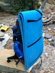
  Because there is no avoiding swimming in this canyon many people use flotation devices to ferry packs across the big deep pools. I use dry bags to keep my stuff dry and some cheap foam sleeping pads doubled up and folded in half strapped to the back of my pack to help float the pack. I find the blow up flotation devices just get popped by all the vegetation, but not using something to float the pack will cause your pack to weigh a lot more as it soaks up the water.
  Some people install grommet type holes in the packs to help them drain. For shoes I just hike wade and swim in low cut hiking boots. Water shoes and sandals will just not cut it and your feet will take a pounding. Of course do not drink the water without purification. And never go in the middle part of this canyon in monsoon season due to flash flood potential (get a good weather report before your trip). Well I hope this helps any who want to take on the Wet Beaver Creek Wilderness Area.
Access: Drive 40 miles south from Flagstaff on Interstate 17. Leave the interstate at the AZ 179 interchange. Turn east under the highway and drive about 2.5 miles east to the old Beaver Creek Ranger Station turnoff. Turn north about a quarter mile to the parking lot and trail head.
Wet Beaver Creek runs from east to west and just like West Clear Creek it has many deep pools that you must swim to travel up or down the canyon. And just like West Clear Creek there is no trail in the middle part of the canyon and the going can be very difficult. But just like West Clear Creek the payoff is a remote wilderness experience of extreme beauty and solitude.The total distance to do a through hike of this canyon from Waldroup Place up on the rim to the trail head parking lot at the mouth of the canyon is 15 miles. This would require a car shuttle. Many people start at the trail head parking lot and then do a loop hike by taking the Apache Maid Trail up to the rim and then drop down into the canyon at Waldroup Place and then travel down the canyon and back to the Bell Trail parking area.
The majority of the people that visit Wet Beaver Creek are day hikers that come up the Bell Trail and stop at a swimming hole known as The Crack.
The Crack has two deep pool conected by a short slot or channel and has this unique red rock diving board. The Crack is about four miles from the parking area on a maintained trail. The first two miles is a wide double track or jeep trail, and the rest is a foot trail along a ledge or bench above the creek until you get to The Crack. The trail is called the Bell Trail and it was used in the old days to move cattle from the lower areas up to the rim for the summer.To do the loop trip you will take the Apache Maid Trail up and around. After about two miles you will come to a trail on the left called Apache Mail trail #15. This trail climbs steeply up to the north rim of the canyon gaining at least 1200 feet of elevation and then gets very vague as it travels on intermittent jeep tracks east to the access point called Waldroup place at the east or upper end of the canyon. This is a long trek with no water sources, that will gain and loose altitude as you go and if you are going to go down the canyon it means you will be doing this in the hot summer months. It is about 9 and 1/4 miles from the trail head to Waldrop Place. It is about 2 miles from Waldroup Place to get down into the main canyon. Then about 9 miles down the canyon till you pick up the Bell trail near the crack and about 4 more miles back down the Bell trail to the car for a total of around 24 miles for the loop. I once drove around to Waldroup place and just started from up there and just returned back the same way. This is a rugged access with seven dry falls you have to find a way around. When you get into the canyon it is dry at first but as you head west or downstream you will soon find several springs that are the source of Wet beaver Creek and then right away there will be a few big pools you must swim to go any farther down the canyon. The travel in the 9 mile trailess part of the canyon is very tough and strenuous with travel average at 3/4 miles per hour. To do the loop you could do it in two days but most would take three to make it enjoyable.
Anyway most people just come up from the Bell Trail to The Crack for a day hike and swim . There are also taller cliffs on one side that brave or crazy people sometimes jump off into the water. The Crack can be very crowded on hot summer days, but this is where most of the people stop. But if you keep going up the canyon you will find it to be beautiful, wild, and best of all there will be few people.
Now the walk up the Bell Trail is a dry and hot four miles with very little shade. And much of it is up away from the creek with the sound of the water below teasing you as you go. In one spot along the Bell Trail there is a large basalt boulder with what appears to be Anasazi Petroglyphs. This is not unusual here, and I have fould many sites with rock art in the surrounding area. This beginning part of the canyon is wide open but then starts to close in after a few miles. At about 2.7 miles there is a trail to the right that goes down to the creek called the Weir Trail, this is tempting but will not get you to The Crack and the best stuff. Keep on the upper trail and it will take you up on a bench high above the creek. And at about the 4 mile mark you will see a trail (The Bell Trail) heading down to the right toward the creek and one going straight. Take the straight one that will take you upstream to The Crack. The bell Trail will take you to Bell Crossing and cross the creek and then will climb the steep canyon walls to the rim above.Once at The Crack to head up stream you will just be boulder hopping, wading, fighting through willow thickets and brush, and swimming. You will be able to see some paths that others have taken that are the "least resistance" and that will help but this is primitive route finding. You will be doing extensive boulder hopping along the banks or in the creek. The creek is lined with willows that you will need to fight your way through as you cross from one side of the creek to the other. The creek bottom itself is very slippery with algae covered rock and it is best to avoid walking in the creek bottom as it will severely slow you down. After at around an hour from The Crack you will encounter the first big pool or obstacle.You must swim through this long pool to go any farther. And soon this will become the mode of travel so get used to it. In fact that is the fun part of this trip to swim in the cool deep shady pools while the rest of Arizona is baking in the hundred plus heat. Another half hour or more upstream you will encounter more deep pools you must swim and soon there is a series of pools one after another that you will have to swim to go any farther. In this section of the canyon the cliffs close in around you and get tall and majestic. This is a true wilderness experience, with few encounters with other people. Because most people won't swim with a full pack as this requires. Here it is just one pool after another. In some places there are trees wedged in the slots many feet above the water surface. A good reminder to not do this trip in the monsoon season. Michael R. Kelsey's book Canyon Hiking Guide To The Colorado Plateau says there are 32 places where you must float a pack, and 23 of these you must swim because you can't touch bottom I have seen beavers living in this area and I'm sure there could be bear or mountain loins too, for it is a real wild place. There are very few camp spots once all the swimming starts because the canyon walls close in on the creek bed. The best places are just before the first swim or just after the first big swim. Here is a great secluded area with great beauty to enjoy while you rest up for the return trip. You could try to get in to this inner section and back out in a day but that would be one really long hard day with little time to take to enjoy the place. Even breaking it up into two days by camping overnight makes for two very hard and strenuous days of hiking due to the extreme conditions (especially if you are an old guy like me). Because there is no avoiding swimming in this canyon many people use flotation devices to ferry packs across the big deep pools. I use dry bags to keep my stuff dry and some cheap foam sleeping pads doubled up and folded in half strapped to the back of my pack to help float the pack. I find the blow up flotation devices just get popped by all the vegetation, but not using something to float the pack will cause your pack to weigh a lot more as it soaks up the water. Some people install grommet type holes in the packs to help them drain. For shoes I just hike wade and swim in low cut hiking boots. Water shoes and sandals will just not cut it and your feet will take a pounding. Of course do not drink the water without purification. And never go in the middle part of this canyon in monsoon season due to flash flood potential (get a good weather report before your trip). Well I hope this helps any who want to take on the Wet Beaver Creek Wilderness Area.Access: Drive 40 miles south from Flagstaff on Interstate 17. Leave the interstate at the AZ 179 interchange. Turn east under the highway and drive about 2.5 miles east to the old Beaver Creek Ranger Station turnoff. Turn north about a quarter mile to the parking lot and trail head.