I've been having this crazy idea for a long time. The big picture would be a trail that connects the sierra (Mt. Whitney) to the Wasatch (sunset peak). It would go across the great basin. The California side would take the lowest to highest (or highest to lowest route in this case) to get from whitney to CA/NV border. I know there are a few options across Nevada and it would be good to somehow hit Ruby Mountains and Great Basin NP on the route across Nevada.
Right now though I am focused on the Utah portion, specifically Wendover to Sunset peak. I have a really good idea of how to get from Jordan Park to Sunset Peak in two sections.....all familiar trails I have walked.
1. Jordan Park to Wasatch Drive (Salt Lake Urban Street Hike... SLUSH)
9 line to main street or west temple
main street to 2200 S
street car trail to fairmont park
parleys trail to wasatch drive
2. Wasatch drive to Sunset peak
Grandeur from the west
Grandeur peak to church fork
pipeline to elbow fork
elbow fork to the terraces
terraces to white fir pass
white fir pass to baker pass
desolation trail baker pass to butler fork (or mill d north)
mill d south to cardiff road
cardiff road over the ridge drop down into alta
across the alta meadows (albion basin) to catherine pass TH
catherine pass TH to sunset peak
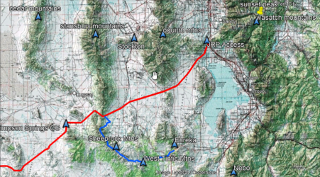
My question is...what would be the best route to go from wendover to Jordan Park? Ideally some criteria to consider would be a resupply or two crossing a town (ideally) or road (second option). South of I-80 the route runs into some land ownership issues with Dugway proving grounds....north of I-80 the route looks pretty soggy.
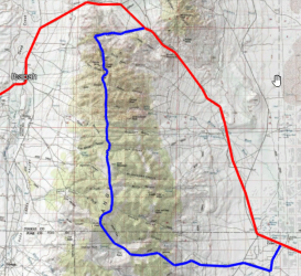
One option would be following the NV/UT border south until I'm well south of Dugway proving grounds....head east....resupply at food cache at simpson springs campground....head north through skull valley....cross stansbury mountains....resupply in tooele valley....cross the oquirrhs and then somehow connect e.g. butterfield canyon to the jordan river parkway?
I haven't spent much time in stansbury or oquirrh mountains. Any recommendations for major canyon thoroughfares running west to east across these north/south ranges that might be the best route?
Other ideas of how to make this route a reality?


