Tweedie
Member
- Joined
- Feb 5, 2024
- Messages
- 11
This is a report of the trip my Son and I took from Elk Park to Needleton via Vestal, Balsam and Noname basins. It is an off trial route with lots of route finding and adventure. it is very remote and rarely visited.
The only beta on this trip I was able to find called it the Bruce Traverse (https://mtnguide.net/the-bruce-traverse/ )This is similar to the Kodiak High Route but it follows the West side of the main Weminuche North-South ridge instead of the East, which allows you to camp in lower treed valleys instead of crossing mostly scree. We did not summit any peaks on this trip, but it is useful access to many of the backcountry 13ers in the area. The challenge here was we had to cross a number of passes without well known trails. I had some anxiety around the level of scrambling on these passes and the amount of snow I could expect. it turned out to be great with minimal challenges on snow or steepness.
Overall route from Elk Park to Needleton

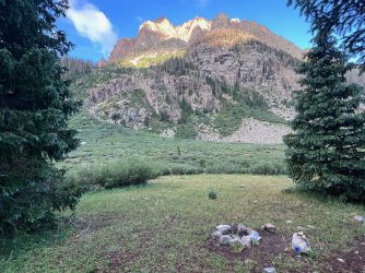
July 29 – My Son and I took the diesel train from Rockwood to Elk Park with plan to hike through the Weminuche to Needleton and get the train home. There were lots of tourists and peak baggers on the train heading to Silverton and Chicago basin. Three other people got off at Elk Park. They were heading on a 7-day bag pack trip to Needleton too, but they were heading over to Vallecito drainage, which is a much more common route.
We started hiking around 1130 and made good time to the beaver ponds with a short stop for lunch along the way next to Elk Creek. On the way we got our first view of Vestal and Arrow. From the beaver ponds we went around the big rock at the north end of the first pond and picked up the trail on the other side. The creek crossing was simple with a couple of logs across the trail. The trail from there was easy to follow and very steep in places. Lots of down logs and minimal professional maintenance, but easy to follow.
Still on the CT looking at Vestal and Arrow

Once we reached the lower basin around 230pm we took a break and discussed camp locations. Our favorite spot on the ledge above the basin was taken so we opted to try our luck with the upper basin. The upper basin is smaller, about 400’ elevation higher and similar. Luckily there was a nice ledge above the basin with awesome views of vestal and the trinities. The photo opportunities that evening were awesome. We met someone in the basin that showed us a cool little set of raised lakes that were the perfect location for sunset shots of trinities.
Trinities from small ponds.

Upper Vestal Basin (Trinities in the background)

July 30th - We woke up had breakfast and left camp around 930am heading for the vestal trinity saddle. There is a trail fork just before the upper basin opens up with a trail leading up to the base of Vestal. This avoids the large amounts of willows on the trail from the lower basin to Vestal Lake. We followed the trail most of the way but lost it on the ramps near the top. We just picked our way through the rocks and grass to the flat area between Vestal and West Trinity. It was steep and simple. From there were made our way through boulder fields and grassy patches to the base of the saddle. The saddle is loose to a pain in the ass, but not overly complicated. We took turns climbing to avoid rockslides down to each other. It is simple route finding but the sliding dirt and rock make it frustrating. We reached the saddle top around 1100am.
Vestal Peak

Route from Upper Vestal camp to above Vestal Lake

The view from Vestal/Trinity Saddle

From the saddle there is a faint trail following the grassy gully directly to the north. The trail is steep and grassy all the way. It hugs the left side of the gully. Avoid the temptation to turn east too soon, you need to traverse under the large cliff band to avoid cliffing out. At around 12,400’ the trail heads to the east along a grassy ledge below the cliffs. We followed it for a while then turn south to intersect the west end of balsam lake. Balsam lake is amazing. Turquoise blue water and visited by very few people. We reached the lake around 12 and setup camp just in time for a serious rainstorm. There is a lot of beetle kill around the lake and lots of down logs as there is around Vestal. We hiked around the west side of the lake to a previously disturbed campsite near the lake outlet.
The north side and south side of the Vestal Trinity saddle


It rained and hailed very hard and with little previous moisture it just pooled on the ground. We scrambled to dig ditches around our tent and keep the water from getting in. It took a solid hour to get the water under control and for the rain to subside. It continued to rain all evening. We setup our extra tarp for dinner but it was still windy, cold, and wet most of the time. The hail and rain turned to snow on Peak 7 and the flash flood caused waterfalls to tumble down from all around peak 7. It was impressive.
Balsam Lake from the Route to Peak 5/6

July 31 - We woke up and had breakfast then started the hike over to Noname basin. We crossed the creek out of Balsam Lake right where it runs out of the lake in braids. We were able to hop the small braids and keep our shoes dry. The main creek was higher than the day before due to the heavy rains and hail. There was a log crossing near our camp, but it led to a cliff face that would be hard to get out.
We climb through the trees aiming for the foot of the scree. There is a trail along the scree that wraps around the large cliff face. We followed it into the upper basin. There were a few places where we need to climb a little, but it was mostly trail with cairns. Once on top we could see the peak 5/6 pass. The top was mostly grass, boulders and cliffs. We kept to the left negotiating cliff section. We reached the upper basin just below the pass. The pass was mostly rock and dirt with a short steep dirt section near the top. There looked to be a couple of options here to reach the top.
Route to Peak 5/6 saddle


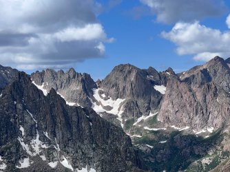
From the top we could see a lot of 13ers and the Chicago basin 14ers. The Grenadiers were awesome to view from this side. Jagged Peak was very impressive from this close. After a snack and some photos, we headed for Noname Lake. The lake was turquoise blue and very rugged. No trees around it at all and cliffs or scree on many sides. We had thought to camp here but decided to move on. There are not a lot of good camp location around this lake due to its altitude.
Peak 6 Lake with Jagged in the background

We debated our next move. We could climb the Jagged pass and camp at sunlight, camp in the upper Noname Basin or move to the lower Noname Basin. We had a plan to at least make a day trip over to sunlight to look for the infamous lost Durango Nature Studies (DNS) hat from 2021. On a trip in 2021 my son left his favorite bucket hat from the Durango Nature Studies on a knoll just east of jagged peak. By the time he remember it, we were an hour away and could not go back. This trip was to retrieve that hat! AKA Operation Bucket Hat!
Looking down Noname valley from Jagged saddle

We decided to hike down to upper Noname and day trip over to sunlight basin. We hiked towards jagged pass to avoid cliff bands and to get a look at the pass. Then cut back down to the small lake just below the pass. We followed the rocks on the way down following cairns but the next day we would find the south side of the creek was grassy and easier to climb and descend. We continued down to the braided lake area further down and found a nice, raised camp area near the west end of the basin. There was also a pre disturbed fire ring.
Route down from Noname Lake

That night around 2am there was another severe storm. Strong winds and heavy rain pounded against our tent. I was happy to have a strong tent. The storm lasted about an hour, and we managed to stay dry. Thunder and lightning were all around us. My son counted many strikes less than a mile away.
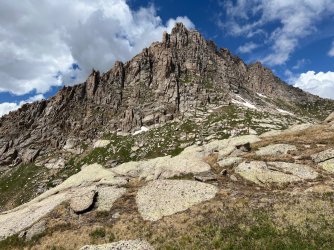
Jagged Peak

August 1 - The next morning we packed up a day pack and headed for Jagged Pass. We stayed to the left near the pass on dirt with some vegetation that made climbing easier. We went up on the left and then down on the right. The pass looked daunting from afar but up close it wasn’t too bad. near the top a marmot came out of his hole and approached us. He stood directly in the trail almost like he was looking for a toll to cross the pass or something. He eventually retreated empty handed.
Route over Jagged Pass (up to the north (left) and down to the South (right)

Across the pass we could see across Vallecito creek to the distant mountains. Nearer we looked over the spires of Jagged and Leviathan. Jagged is an impressive mountain. We drop down to the basin and then down further to the knoll where the hat had been left 2 years prior. At first, we had no luck in our search, so we ate lunch. After lunch we searched again and amazingly my son found his hat. It was rough looking. Chewed on by Marmots and Pika and beat up by the weather and two winters. But it was there. Most of the DNS symbol was gone but you could still read his name marked into the top with a sharpie. Operation Bucket Hat was a success.
After a few celebratory photos we head back towards Jagged Pass. On the way down from Jagged we had followed our old route down the easter grassy slope to the knoll just before sunlight basin. On the way back we went directly toward the base of jagged and towards the upper basin. This cut off some significant distant over ridges and knolls. Our marmot friend was nowhere to be seen on the way back, it must be a one-way toll. Down from Jagged on the Noname side we kept to the left on loose dirt which was easy to skid down. Then we navigated a few boulders then more grassy slopes to the valley floor. We cross over the marshy area below Jagged through a dry section in the center.
Camp in upper Noname with the north side of Eolus in the background

On the way up to Jagged we found a better route between Upper Noname Basin and the pass. On the way down the day before we followed what looked like a main route, but it led to a steep sandy section that was passable but steep and very loose. On the way up to the pass we found an easier route that access the ridge further to the west and is mostly grassy slopes.
Once back at camp we packed up and headed for lower Noname Basin. The trail exited the valley to the southwest near the creek and a really nice camp spot in the trees. The trail is steep and mostly easy to navigate. We lost it a few times but quickly found it again. We saw lots of bear droppings along the trail as well as in the upper basin. There were also turned over rocks that are usually a sign of bears in the area. The trail down to Noname had been recently traveled based in the flattened vegetation. We discussed the potential of it being a bear or a hiker. Both could be very likely. We planned a solid bear hang for our food that night.
Lower Noname Basin was easily reached but during a rain shower, so our shoes and rain gear were all wet. The are some amazing views of knife point on the way down. In lower Noname there is an excellent camp spot right along the trail just west of the confluence with the small creek from Twin Thumbs Pass. We camped there for the night and hung our food well.
Camp in Lower Noname, Monitor in the background, we climbed the rocky couloir direct in the center of the photo.

August 2 - The next morning we were headed for Ruby Lake. The route from Noname to the base of Peak 12 is nonexistent. At least as far as I could tell. Some people had done it before and wrote about it but there seemed to be no known common route. We planned to climb the couloir opposite our camp spot and exit it near the top then cross along below the cliffs of Monitor Peak. First, we had to cross the creek. We crossed near camp where a small animal trail entered the creek and then pushed through willows to the base of the couloir.
Route up couloir towards Peak 12 pass

The couloir was simple but got steep near the top, so we exited to the willows around 11,400’. Previous trip reports went through the trees and noted a lot of down logs on the way. The couloir avoided most of the willows and all the down trees. From the top of the couloir, we stayed high near the cliffs and made our way towards the Peak 12 pass. We hit the odd goat trail, but it was mostly off trail hiking and choosing our routes. From the pass we had a great view of the Noname Basin and all the peaks around us.
We made our way down towards upper Ruby Basin with a plan to have lunch in the basin where we camped the year before. The trail came and went, and we continued to go down. After lunch we followed the trail down to Ruby Lake. The trail disappears and reappears in the willow right after the basin and then again right before the lake. Near the lake there is a lot of dead fall trees that make for a tough hike if you descend too far. We tried to stay high on the rocks. We did lose the trail a few times but ended up at the lake all the same. Near the west end of the lake there is an ideal camp spot that is frequented by fishermen. That night we caught our dinner, a small brook trout and a cutthroat.
Ruby Lake

August 3 - We got up this morning and Moose walked past our campsite. He seemed to be trying to sneak by undetected, but when I noticed him, he paused for a second and then took off running up the side of the lake. We left Ruby Lake around 10am heading for the train at Needleton. The trail has a lot of down trees and can be hard to follow in places. The worst part is between Ruby Lake and the knoll on the ridge leading to Tie Creek Basin. That section has a lot of down logs and lots of routes bypassing logs. So, the trail is hard to follow. Once over the knoll the trail gets easier to follow but still lots of down timber. Near the knoll there is a section of down trees that is impassable. The best way to avoid it is to avoid the knoll altogether and try to intersect the trail part way down the hill on the Ruby side. The Ruby Lake trail desperately needs some maintenance, but it is passable and worth the hike.
We met the train at 300pm and took the abbreviated train ride to Rockwood. The trip was a great success with finding my son’s hat and seeing some amazing rarely touched mountains. We didn’t see a single person between leaving Vestal Basin and meeting some locals on the trail crossing Pigeon Creek. We saw lots of marmots, squirrels, trout, moose and signs of bears and goats, we even heard coyotes yelping at each other one morning near Balsam Lake. The weather was wildly unpredictable (as it always is in the mountains), but we had lots of good days. The whole trip was incredibly peaceful and a great connection with nature. With a little route finding this is a reasonable route to follow, the highest class climb we did was class 2 and there was very little exposure on the whole route.
The only beta on this trip I was able to find called it the Bruce Traverse (https://mtnguide.net/the-bruce-traverse/ )This is similar to the Kodiak High Route but it follows the West side of the main Weminuche North-South ridge instead of the East, which allows you to camp in lower treed valleys instead of crossing mostly scree. We did not summit any peaks on this trip, but it is useful access to many of the backcountry 13ers in the area. The challenge here was we had to cross a number of passes without well known trails. I had some anxiety around the level of scrambling on these passes and the amount of snow I could expect. it turned out to be great with minimal challenges on snow or steepness.
Overall route from Elk Park to Needleton
July 29 – My Son and I took the diesel train from Rockwood to Elk Park with plan to hike through the Weminuche to Needleton and get the train home. There were lots of tourists and peak baggers on the train heading to Silverton and Chicago basin. Three other people got off at Elk Park. They were heading on a 7-day bag pack trip to Needleton too, but they were heading over to Vallecito drainage, which is a much more common route.
We started hiking around 1130 and made good time to the beaver ponds with a short stop for lunch along the way next to Elk Creek. On the way we got our first view of Vestal and Arrow. From the beaver ponds we went around the big rock at the north end of the first pond and picked up the trail on the other side. The creek crossing was simple with a couple of logs across the trail. The trail from there was easy to follow and very steep in places. Lots of down logs and minimal professional maintenance, but easy to follow.
Still on the CT looking at Vestal and Arrow
Once we reached the lower basin around 230pm we took a break and discussed camp locations. Our favorite spot on the ledge above the basin was taken so we opted to try our luck with the upper basin. The upper basin is smaller, about 400’ elevation higher and similar. Luckily there was a nice ledge above the basin with awesome views of vestal and the trinities. The photo opportunities that evening were awesome. We met someone in the basin that showed us a cool little set of raised lakes that were the perfect location for sunset shots of trinities.
Trinities from small ponds.
Upper Vestal Basin (Trinities in the background)
July 30th - We woke up had breakfast and left camp around 930am heading for the vestal trinity saddle. There is a trail fork just before the upper basin opens up with a trail leading up to the base of Vestal. This avoids the large amounts of willows on the trail from the lower basin to Vestal Lake. We followed the trail most of the way but lost it on the ramps near the top. We just picked our way through the rocks and grass to the flat area between Vestal and West Trinity. It was steep and simple. From there were made our way through boulder fields and grassy patches to the base of the saddle. The saddle is loose to a pain in the ass, but not overly complicated. We took turns climbing to avoid rockslides down to each other. It is simple route finding but the sliding dirt and rock make it frustrating. We reached the saddle top around 1100am.
Vestal Peak
Route from Upper Vestal camp to above Vestal Lake
The view from Vestal/Trinity Saddle
From the saddle there is a faint trail following the grassy gully directly to the north. The trail is steep and grassy all the way. It hugs the left side of the gully. Avoid the temptation to turn east too soon, you need to traverse under the large cliff band to avoid cliffing out. At around 12,400’ the trail heads to the east along a grassy ledge below the cliffs. We followed it for a while then turn south to intersect the west end of balsam lake. Balsam lake is amazing. Turquoise blue water and visited by very few people. We reached the lake around 12 and setup camp just in time for a serious rainstorm. There is a lot of beetle kill around the lake and lots of down logs as there is around Vestal. We hiked around the west side of the lake to a previously disturbed campsite near the lake outlet.
The north side and south side of the Vestal Trinity saddle
It rained and hailed very hard and with little previous moisture it just pooled on the ground. We scrambled to dig ditches around our tent and keep the water from getting in. It took a solid hour to get the water under control and for the rain to subside. It continued to rain all evening. We setup our extra tarp for dinner but it was still windy, cold, and wet most of the time. The hail and rain turned to snow on Peak 7 and the flash flood caused waterfalls to tumble down from all around peak 7. It was impressive.
Balsam Lake from the Route to Peak 5/6
July 31 - We woke up and had breakfast then started the hike over to Noname basin. We crossed the creek out of Balsam Lake right where it runs out of the lake in braids. We were able to hop the small braids and keep our shoes dry. The main creek was higher than the day before due to the heavy rains and hail. There was a log crossing near our camp, but it led to a cliff face that would be hard to get out.
We climb through the trees aiming for the foot of the scree. There is a trail along the scree that wraps around the large cliff face. We followed it into the upper basin. There were a few places where we need to climb a little, but it was mostly trail with cairns. Once on top we could see the peak 5/6 pass. The top was mostly grass, boulders and cliffs. We kept to the left negotiating cliff section. We reached the upper basin just below the pass. The pass was mostly rock and dirt with a short steep dirt section near the top. There looked to be a couple of options here to reach the top.
Route to Peak 5/6 saddle
From the top we could see a lot of 13ers and the Chicago basin 14ers. The Grenadiers were awesome to view from this side. Jagged Peak was very impressive from this close. After a snack and some photos, we headed for Noname Lake. The lake was turquoise blue and very rugged. No trees around it at all and cliffs or scree on many sides. We had thought to camp here but decided to move on. There are not a lot of good camp location around this lake due to its altitude.
Peak 6 Lake with Jagged in the background
We debated our next move. We could climb the Jagged pass and camp at sunlight, camp in the upper Noname Basin or move to the lower Noname Basin. We had a plan to at least make a day trip over to sunlight to look for the infamous lost Durango Nature Studies (DNS) hat from 2021. On a trip in 2021 my son left his favorite bucket hat from the Durango Nature Studies on a knoll just east of jagged peak. By the time he remember it, we were an hour away and could not go back. This trip was to retrieve that hat! AKA Operation Bucket Hat!
Looking down Noname valley from Jagged saddle
We decided to hike down to upper Noname and day trip over to sunlight basin. We hiked towards jagged pass to avoid cliff bands and to get a look at the pass. Then cut back down to the small lake just below the pass. We followed the rocks on the way down following cairns but the next day we would find the south side of the creek was grassy and easier to climb and descend. We continued down to the braided lake area further down and found a nice, raised camp area near the west end of the basin. There was also a pre disturbed fire ring.
Route down from Noname Lake
That night around 2am there was another severe storm. Strong winds and heavy rain pounded against our tent. I was happy to have a strong tent. The storm lasted about an hour, and we managed to stay dry. Thunder and lightning were all around us. My son counted many strikes less than a mile away.
Jagged Peak
August 1 - The next morning we packed up a day pack and headed for Jagged Pass. We stayed to the left near the pass on dirt with some vegetation that made climbing easier. We went up on the left and then down on the right. The pass looked daunting from afar but up close it wasn’t too bad. near the top a marmot came out of his hole and approached us. He stood directly in the trail almost like he was looking for a toll to cross the pass or something. He eventually retreated empty handed.
Route over Jagged Pass (up to the north (left) and down to the South (right)
Across the pass we could see across Vallecito creek to the distant mountains. Nearer we looked over the spires of Jagged and Leviathan. Jagged is an impressive mountain. We drop down to the basin and then down further to the knoll where the hat had been left 2 years prior. At first, we had no luck in our search, so we ate lunch. After lunch we searched again and amazingly my son found his hat. It was rough looking. Chewed on by Marmots and Pika and beat up by the weather and two winters. But it was there. Most of the DNS symbol was gone but you could still read his name marked into the top with a sharpie. Operation Bucket Hat was a success.
After a few celebratory photos we head back towards Jagged Pass. On the way down from Jagged we had followed our old route down the easter grassy slope to the knoll just before sunlight basin. On the way back we went directly toward the base of jagged and towards the upper basin. This cut off some significant distant over ridges and knolls. Our marmot friend was nowhere to be seen on the way back, it must be a one-way toll. Down from Jagged on the Noname side we kept to the left on loose dirt which was easy to skid down. Then we navigated a few boulders then more grassy slopes to the valley floor. We cross over the marshy area below Jagged through a dry section in the center.
Camp in upper Noname with the north side of Eolus in the background
On the way up to Jagged we found a better route between Upper Noname Basin and the pass. On the way down the day before we followed what looked like a main route, but it led to a steep sandy section that was passable but steep and very loose. On the way up to the pass we found an easier route that access the ridge further to the west and is mostly grassy slopes.
Once back at camp we packed up and headed for lower Noname Basin. The trail exited the valley to the southwest near the creek and a really nice camp spot in the trees. The trail is steep and mostly easy to navigate. We lost it a few times but quickly found it again. We saw lots of bear droppings along the trail as well as in the upper basin. There were also turned over rocks that are usually a sign of bears in the area. The trail down to Noname had been recently traveled based in the flattened vegetation. We discussed the potential of it being a bear or a hiker. Both could be very likely. We planned a solid bear hang for our food that night.
Lower Noname Basin was easily reached but during a rain shower, so our shoes and rain gear were all wet. The are some amazing views of knife point on the way down. In lower Noname there is an excellent camp spot right along the trail just west of the confluence with the small creek from Twin Thumbs Pass. We camped there for the night and hung our food well.
Camp in Lower Noname, Monitor in the background, we climbed the rocky couloir direct in the center of the photo.
August 2 - The next morning we were headed for Ruby Lake. The route from Noname to the base of Peak 12 is nonexistent. At least as far as I could tell. Some people had done it before and wrote about it but there seemed to be no known common route. We planned to climb the couloir opposite our camp spot and exit it near the top then cross along below the cliffs of Monitor Peak. First, we had to cross the creek. We crossed near camp where a small animal trail entered the creek and then pushed through willows to the base of the couloir.
Route up couloir towards Peak 12 pass
The couloir was simple but got steep near the top, so we exited to the willows around 11,400’. Previous trip reports went through the trees and noted a lot of down logs on the way. The couloir avoided most of the willows and all the down trees. From the top of the couloir, we stayed high near the cliffs and made our way towards the Peak 12 pass. We hit the odd goat trail, but it was mostly off trail hiking and choosing our routes. From the pass we had a great view of the Noname Basin and all the peaks around us.
We made our way down towards upper Ruby Basin with a plan to have lunch in the basin where we camped the year before. The trail came and went, and we continued to go down. After lunch we followed the trail down to Ruby Lake. The trail disappears and reappears in the willow right after the basin and then again right before the lake. Near the lake there is a lot of dead fall trees that make for a tough hike if you descend too far. We tried to stay high on the rocks. We did lose the trail a few times but ended up at the lake all the same. Near the west end of the lake there is an ideal camp spot that is frequented by fishermen. That night we caught our dinner, a small brook trout and a cutthroat.
Ruby Lake
August 3 - We got up this morning and Moose walked past our campsite. He seemed to be trying to sneak by undetected, but when I noticed him, he paused for a second and then took off running up the side of the lake. We left Ruby Lake around 10am heading for the train at Needleton. The trail has a lot of down trees and can be hard to follow in places. The worst part is between Ruby Lake and the knoll on the ridge leading to Tie Creek Basin. That section has a lot of down logs and lots of routes bypassing logs. So, the trail is hard to follow. Once over the knoll the trail gets easier to follow but still lots of down timber. Near the knoll there is a section of down trees that is impassable. The best way to avoid it is to avoid the knoll altogether and try to intersect the trail part way down the hill on the Ruby side. The Ruby Lake trail desperately needs some maintenance, but it is passable and worth the hike.
We met the train at 300pm and took the abbreviated train ride to Rockwood. The trip was a great success with finding my son’s hat and seeing some amazing rarely touched mountains. We didn’t see a single person between leaving Vestal Basin and meeting some locals on the trail crossing Pigeon Creek. We saw lots of marmots, squirrels, trout, moose and signs of bears and goats, we even heard coyotes yelping at each other one morning near Balsam Lake. The weather was wildly unpredictable (as it always is in the mountains), but we had lots of good days. The whole trip was incredibly peaceful and a great connection with nature. With a little route finding this is a reasonable route to follow, the highest class climb we did was class 2 and there was very little exposure on the whole route.