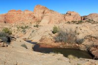
Water source information - Escalante/CRNP area

LarryBoy

Hiker Trash
.
Joined
Jan 4, 2015
Messages
2,808
Hey folks,

Headed out shortly for a trip across the Fold/Escalante area. I've got plenty of water source beta but no recent reports for the following sources... wondering if anybody has been in the area recently and can provide a report?

Lower Muley - in main wash near Cowboy Cave
Potholes up @Jammer's sneak route of lower-end LMT
Colt Mesa waterworks
Upper Choprock (idk what the fork is called, but the non-technical one)

Thanks in advance!
 
Yeah things were grim there for a while. Maybe still are. Daggone drought.
 
Not the exact same location...
At least on the western Escalante side the there was water in a lot of places last week, including some where there was not water last year at the same time. So the outlook may actually be good with all the rain the past few weeks.
 
Almost everything capable of holding water along our Beehive Traverse hike last week in CRNP had water from recent rains. I think you'll find as much water as you could expect to at any point of the year down there now, especially with the sun getting lower in the sky now and temperatures cooling. I don't imagine much of it will dry up any time soon.
 
Bryce was the closest precip data I could find. We had a similar amount of precip near Zion Sun/Mon, and things haven't yet dried out.

Screen Shot 2018-10-25 at 3.22.47 PM.png
 
Yeah it rained hard in Zion this weekend. Had to bail on some hiking plans but I'm not going to complain about actually getting a little moisture!
 
Anxious to hear what you find this time of year as nearly all my data is from past spring seasons. With that caveat -- I really bet there will be water in the potholes exiting LMT and near the middle of Choprock (go up "Poison Ivy Fork" a ways to check it out and increase the odds of finding water.) In the GSENM Fb Group, somebody recently posted a pic of the Colt Mesa tanks and they looked nearly empty. Also of possible use -- several medium potholes in the area of 37°43'44.32"N, 111° 1'56.41"W are likely to hold water quite a while after a storm.
 
Also not quite in the same location, but every pothole I came across west of the Escalante around Spencer Canyon last Fri 10/19 was holding at least some water, and many of the deeper ones were quite full. The day prior I had picked up a backpacker along the Burr Trail Rd who was doing the Hayduke Trail, and he mentioned that he hadn't had any problems finding water since it had been raining for much of the week and half prior, but he hadn't made it to the areas in question.

For more precip data, NOAA's rainfall estimates from radar are here. Scroll down below the map to change the time-frame of interest.

IMG_2353.JPG
 
Thanks all. I'll definitely provide some updates on the springs, in particular... the potholes should be fine but I'm a little warier of the springs. Out of curiosity, Piper, who was the Hayduker you picked up?
 
Thanks all. I'll definitely provide some updates on the springs, in particular... the potholes should be fine but I'm a little warier of the springs. Out of curiosity, Piper, who was the Hayduker you picked up?

First name Samson, didn't get his last name.
 
I found plenty of water (and quicksand!) as well.

@Jammer there were a couple of good pools at the GPS coords you cited. Looked fairly reliable as they were a couple feet deep and in sheltered locations.

Colt Mesa waterworks have about 2 inches of clear water in the lower tank. Upper tank is full of radioactive-green water. Probably falls in the "only for the truly desperate" category unless your standards are exceptionally low.
 
Oh and there are several useable pools in Lower Muley near Cowboy Cave (or is it Cowboy Cove? Heard it both ways...) as well.
 
Similar threads
Thread starter Title Forum Replies Date
C Paria Canyon water source - August 2020 Trip Planning 2
Janice Caching water? General Discussion 8
Bob 206 mile water trail Trip Planning 0
kwc Smoke on the water … fire in the sky … General Discussion 6
JBG Water Beta 2022 - Highline Trail Trip Planning 6
regehr potable water in Escalante town? Trip Planning 6
regehr water in lower muley twist? Trip Planning 0
Janice Water questions - Escalante area Trip Planning 38
Nethos Another water post(Bowdie/Midway) Trip Planning 10
H Access to Grand Gulch via Water Canyon Trip Planning 2
CodyL Winds- Big water slide Trip Planning 3
RyanP Sawyer Squeeze questions: how to pre-filter, and recommended dirty-water bag? Gear 30
Gretchen Millward Trachyte Creek conditions/water Trip Planning 0
B In Government Trail and out Water Canyon Trip Planning 3
Christo Water availability:Thorofare Yellowstone Trip Planning 6
RyanP road from Hite to Water Hole Flat Trip Planning 20
JBG Water on the Highline Trail - 2021 Trip Planning 2
garyhost Cedar Mesa Utah Trip. Conditions? Water? Trip Planning 8
RyanP Conditions (water/bugs) for Escalante/Death Hollow Trip Planning 27
J Grand Gulch (Kane to Bullet) Water Availability Trip Planning 9
E Water in the Needles early-May 2021 Trip Planning 3
S Packrafting Escalante - FiftyMile Creek and low water level Lake Powell Trip Planning 8
F Stevens Canyon/southern escalate water availability. Trip Planning 16
gnwatts Grand Gulch water Trip Planning 6
W 9 Days Solo Escalante Loop in October (water advice) - Stevens Canyon, Baker Route over Waterpocket fold, Halls Narrows to Moody Canyons Trip Planning 11
M Dark Canyon Complex Water Data Trip Planning 4
P Salt Creek water Backpacking 2
P Pitchstone Plateau water Backpacking 7
OldBill Water treatment tablets and Cryptosporidium Gear 15
I Water in Frisky Creek south of Highway 12 in the Grand Staircase? Trip Planning 0
DrNed Water Sources McKee Draw to Leidy Peak Trip Planning 12
M Water containers Gear 28
fossana UT 2020 water outlook General Discussion 2
Rockskipper Maybe it was the BBQ sauce (guy survives 3 weeks w/ no food or water after getting lost) General Discussion 0
regehr Water higher up in Virgin Springs Canyon? Trip Planning 17
RyanP Water in Needles District in early April this year? Trip Planning 9
RyanP 3-day trip ideas (15-20 miles or so) for late May/early June with good water Trip Planning 9
M Water in Canyonlands Salt Creek early April? Trip Planning 11
Mikjik86 Desert Canyon/Water Shoes? Gear 9
Artemus 2018/2019 Snowpack and Water Year General Discussion 85
gnwatts Water Canyon on Cedar Mesa Backpacking 11
gnwatts Water Canyon (Cedar Mesa) top down General Discussion 11
O Green River/Stillwater Canyon question regarding water Trip Planning 3
blueeyes Black Canyon Water Trail On The Water 16
T Water availability next week in Cedar Mesa & Escalante areas Trip Planning 5
AKay09 5 day hike with lots of water and fishing? Trip Planning 13
KevinBoyer New Water Filter Needed...Suggestions?? Gear 48
Miya Water Resistant Down Sleeping Bags? Gear 36
D Water near EC3 Trip Planning 1
SKLund Water in Cedar Mesa in October Trip Planning 0

Similar threads

Back
Top