Water in Canyonlands Salt Creek early April?

Mayland

Member
Joined
Jan 28, 2019
Messages
11
Hi, looking for info about water availability in Salt Creek Canyon in early April. We are backpacking from Cathedral Butte with night 1 at SC1, nights 2-3 in the at-large area (planning Angel arch trail junction and then a little south of Peekaboo), and then out to Squaw Flat. I spoke with a Canyonlands ranger before the shut-down and he said we couldn't rely on water anywhere below the Upper Jump, but several of the trip reports I’ve read online (here and on BPL) describe water as "plentiful". Anyone have info on whether water will be reliable for the lower stretch below (north of!) the Upper Jump?

We are backpacking with our 3 kids and from past experience (GC Hermit-Tonto) we can comfortably carry water for us all for 24-30 hrs but beyond that is heavy!
Grateful for any info!
Thanks
I can't answer about Salt Creek (sorry) but noticed you've backpacked Hermit-Tonto. We'll be doing that this April and are excited! Any advice?
 
Others can chime in but I've hiked most of it 3 times, early to late April, and there's always been lots of water between Upper Jump and Peekaboo. Measured linearly, more of the canyon had water than did not. Or at least 50/50.
Is it true that this is a heavy snow year in the mountains surrounding the CO Plateau? Since the water originates at altitude on the north slopes of the Abajos, that could help to guess. Or, like Jammer says, as the trip approaches check the Moab NWS rainfall measurements prior. Significant rain inside of two weeks would likely fill bedrock stretches with shallow tanks or deeper side canyon tanks.
Oh, it is hard to access water right at SC1, dry in places and with vertical arroyo cutting. We got water 1/2 mile upstream just south of Kirk's Cabin.. The canyon is dry for a few miles north of SC1 but reappears before SC3.
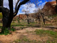
Angel arch junction can be busy, as it is the end of the zone for those coming from Peekaboo. Unfortunately a bunch of majestic old cottonwoods shading nice campsites burned up in a wildfire, clearly visible in Google Earth between 5/16 photoset and 10/16 photoset. had to have been human caused.wneedles-salt-2016.jpg

Pic found on the net.
 
Last edited:
I would rely on finding pools, at minimum, between the upper jump and peekaboo arch. Probably intermittent, but you will definitely find some. Below peekaboo, you'll probably find water, but good chance it's stagnant and nasty.
 
thanks so much to you all! This is so helpful. We will keep an eye on the Moab NWS rainfall in the couple of weeks before our trip. Sounds like we will plan to fill up near Kirk's cabin for our first night at SC1. Day 2 should be good for water but a long hike - SC3 and 4 were both booked when we reserved, so at-large was our only option for night 2. Hoping to find a site as close to the Angel arch junction as possible so we can take an early morning round trip to the arch (if we can persuade our kids to add 3 extra miles!). Day 3 we'll fill up anytime we can, but sounds like we should be OK. Day 4 we are heading out to Squaw Flat (leaving car there) via the Peekaboo trail - hopefully we can fill up south of Peekaboo for that day. We will have a 3L camelback each, a bunch of 2L bottles, and 2 10L dromedaries, so we can fill a lot when we find water. Many thanks!
 
Others can chime in but I've hiked most of it 3 times, early to late April, and there's always been lots of water between Upper Jump and Peekaboo. Measured linearly, more of the canyon had water than did not. Or at least 50/50.
Is it true that this is a heavy snow year in the mountains surrounding the CO Plateau? Since the water originates at altitude on the north slopes of the Abajos, that could help to guess. Or, like Jammer says, as the trip approaches check the Moab NWS rainfall measurements prior. Significant rain inside of two weeks would likely fill bedrock stretches with shallow tanks or deeper side canyon tanks.
Oh, it is hard to access water right at SC1, dry in places and with vertical arroyo cutting. We got water 1/2 mile upstream just south of Kirk's Cabin.. The canyon is dry for a few miles north of SC1 but reappears before SC3.
Angel arch junction can be busy, as it is the end of the zone for those coming from Peekaboo. Unfortunately a bunch of majestic old cottonwoods shading nice campsites burned up in a wildfire, clearly visible in Google Earth between 5/16 photoset and 10/16 photoset. had to have been human caused.View attachment 74646

Pic found on the net.
Very sad that this would be human-caused. Hopefully we can find a spot nearby, we're hoping to do an early morning round-trip to the arch. Thank you for all the info.
 
I can't answer about Salt Creek (sorry) but noticed you've backpacked Hermit-Tonto. We'll be doing that this April and are excited! Any advice?
Janice, we backpacked Hermit-Tonto last April with our 3 kids (then aged 14, 12, 7). Love the Tonto and loved being off the corridor. We camped at Hermit Creek, Salt Creek (beautiful), Indian, then down to Bright Angel, then hiked out. Where are you camping? You probably know already but fill up as much as you can at Monument as there is very little water from there to Indian. Where the trail crosses Monument Creek (in the campsite) there may not be much water - we headed a little upstream and had more luck. Even in April the Tonto was pretty hot out in the sun, so we started early (5am, that was early for us!).
 
Janice, we backpacked Hermit-Tonto last April with our 3 kids (then aged 14, 12, 7). Love the Tonto and loved being off the corridor. We camped at Hermit Creek, Salt Creek (beautiful), Indian, then down to Bright Angel, then hiked out. Where are you camping? You probably know already but fill up as much as you can at Monument as there is very little water from there to Indian. Where the trail crosses Monument Creek (in the campsite) there may not be much water - we headed a little upstream and had more luck. Even in April the Tonto was pretty hot out in the sun, so we started early (5am, that was early for us!).
Thanks so much for your reply about Hermit. (Looks like you got lots of great advice about Salt Creek from others.) We weren't able to get permits for our preferred route but decided to take what we could get. We'll be going all the way from Hermit TH down to Granite Rapids on the first day (ouch for our knees!), then going up just a tiny bit to the Monument camp the next night, then over to Indian the third night. Yes, we will definitely fill up on water at Monument. Helpful to know that Tonto gets hot. 5am is early for us, too, but we'll keep your advice in mind about getting an early start that day. Thanks!
 

Don't like ads? Become a BCP Supporting Member and kiss them all goodbye. Click here for more info.

Back
Top